survey paper 2
This document discusses the key components and processes involved in using a Geographic Information System (GIS). It explains that GIS is a digital database that uses spatial coordinates as a reference system. The main steps in using GIS are: capturing and entering data, integrating the data with selected variables, projecting the data to create maps, and modeling the data. Data entry is the most time-consuming step, requiring identification and editing of map features. The GIS then analyzes and relates the data, allowing comparisons to variables. Projection transforms 3D data into 2D for mapping. Data is structured in a "raster" format and modeled through contour maps. GIS facilitates data storage, manipulation and comparison to produce useful maps and predictions.

Recommended
More Related Content
What's hot (19)
Similar to survey paper 2 (20)
survey paper 2
- 1. Danielle Gavin Geographic Information Systems CONE 2302.001 April 20, 2016
- 2. Geographic Information Systems, or GIS, are special-purpose digital database in which a common spatial coordinate system is the primary means of reference (KEF,2). There are some steps in order to use GIS. First, you must capture the data then the GIS will integrate the information you provided with variables you select. The GIS will then create a projection and finally data modeling. These components of GIS make this technology very important in the production of maps and other geological models. To use the Geographic Information System you must have data and enter the data into the system. This is the most time consuming part of using the GIS system. Operator of the program must identify different objects on the map as well as the space between each. Similarly, anything that should not be on the map must be edited off. A grain of sand could connect areas that should not touch. Blemishes always get recorded so be sure to double check for correctness. This is just the beginning of GIS process. Once you have data entered into the system, the next step is the computer will analyze your data and relate it to each other in any way it can. You may enter variables for it to compare to. This is just a simple correlation calculation that the computer recognizes and can provide to you such as relating rainfall to the time of year based on aerial maps. This step is useful if you are trying to compare your data to something specific. A very important process that GIS completes for you is projection. Projection is a fundamental component of mapmaking (USGI, 2). It transforms three dimensional information into two dimensional information. Projection also allows
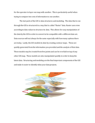
- 3. for the operator to layer one map with another. This is particularly useful when trying to compare two sets of information to one another. The last parts of the GIS is data structures and modeling. The data that is ran through the GIS is structured in a way that is called “Raster” data. Raster uses rows according to data values to structure its data. This allows for easy manipulation of the data by the GIS in order to convert to be compatible with a different data set. Data sources will not always be the same especially with how many options there are today. Lastly, the GIS models its data by creating contour maps. These are quickly generated from the information you provided and the analysis of that data. These models may be created from few points and can be overlaid on top of any other GIS map. These models are also manipulated quickly in order to keep the latest data. Structuring and modeling are the final important components of the GIS and make it easier to identify what your data projects.
- 4. The layers pointed to with an arrow are examples of Raster data layers (NDAA, 1) GIS is arguably one of the most helpful tools in the production of maps. The programs allow for a vast amount of data to be stored, related and manipulated in order to compare and predict trends. It makes it easier to combine a number of locations into a comprehensive visual aide. Technology will continue to adapt and grow in this field which will only make it easier to work with the data. Geographical Information systems have made the job of surveyors less exerting.
- 5. Bibliography K. (2014, September 11). Geographic Information Systems as an Integrating Technology: Context, Concepts, and Definitions. Retrieved from http://www.colorado.edu/geography/gcraft/notes/intro/intro.html Geological information systems. (1991). Washington, D.C.?: U.S. Dept. of the Interior, U.S. Geological Survey. National Weather Service Weather Forecast Office. (2015, May 16). Retrieved from http://www.srh.noaa.gov/bmx/?n=gis