Timmons Group ESRI Replication Solutions
- 1. Automated Data Integration and Sharing To Support the Harrisonburg Rockingham Emergency Communications Center and the Commonwealth of Virginia
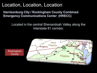
- 2. Rockingham CountyLocation, Location, Location Harrisonburg City / Rockingham County Combined Emergency Communications Center (HRECC)Located in the central Shenandoah Valley along the Interstate 81 corridor.
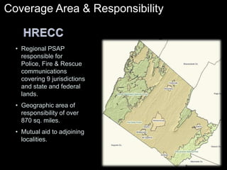
- 3. Coverage Area & Responsibility HRECCRegional PSAP responsible for Police, Fire & Rescue communications covering 9 jurisdictions and state and federal lands.
- 4. Geographic area of responsibility of over 870 sq. miles.
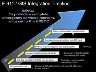
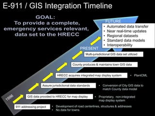
- 5. Mutual aid to adjoining localities.E-911 / GIS Integration TimelineGOAL: To provide a complete,emergency services relevant, data set to the HRECC2007Multi-jurisdictional GIS data set utilizedCounty produces & maintains town GIS dataHRECC acquires integrated map display systemPlantCML
- 6. Conversion of City GIS data to match County data modelAssure jurisdictional data standards1996 GIS data provided to HRECC for map displayProprietary, non-integrated map display systemDevelopment of road centerlines, structures & addresses
- 7. No data for towns911 addressing project
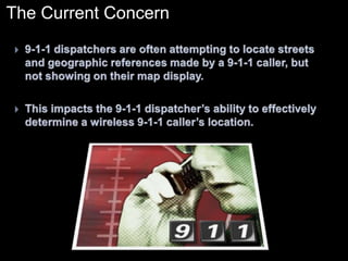
- 8. The Current Concern9-1-1 dispatchers are often attempting to locate streets and geographic references made by a 9-1-1 caller, but not showing on their map display.This impacts the 9-1-1 dispatcherŌĆÖs ability to effectively determine a wireless 9-1-1 callerŌĆÖs location.
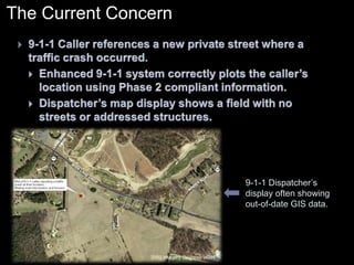
- 9. The Current Concern9-1-1 Caller references a new private street where a traffic crash occurred.
- 10. Enhanced 9-1-1 system correctly plots the callerŌĆÖs location using Phase 2 compliant information.
- 11. DispatcherŌĆÖs map display shows a field with no streets or addressed structures.9-1-1 DispatcherŌĆÖs display often showing out-of-date GIS data.2002 Imagery Courtesy VGIN
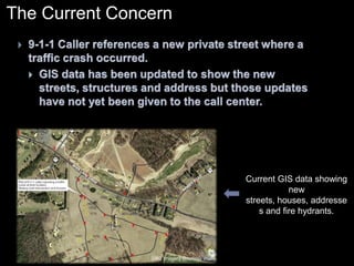
- 12. The Current Concern9-1-1 Caller references a new private street where a traffic crash occurred.
- 13. GIS data has been updated to show the new streets, structures and address but those updates have not yet been given to the call center.Current GIS data showing new streets, houses, addresses and fire hydrants.2002 Imagery Courtesy VGIN
- 14. E-911 / GIS Integration TimelineGOAL: To provide a complete,emergency services relevant, data set to the HRECCFUTURE Automated data transfer
- 15. Near real-time updates
- 16. Regional datasets
- 17. Standard data models
- 18. InteroperabilityPRESENTMulti-jurisdictional GIS data set utilizedCounty produces & maintains town GIS dataHRECC acquires integrated map display systemPlantCML
- 19. Conversion of City GIS data to match County data modelAssure jurisdictional data standards1996 GIS data provided to HRECC for map displayProprietary, non-integrated map display systemDevelopment of road centerlines, structures & addresses
- 20. No data for towns911 addressing project
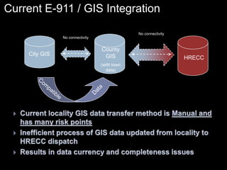
- 21. Current E-911 / GIS IntegrationNo connectivityHRECCNo connectivityCounty GIS(with town data)City GISDataCompatibleCurrent locality GIS data transfer method is Manual and has many risk pointsInefficient process of GIS data updated from locality to HRECC dispatchResults in data currency and completeness issues
- 22. E-911 / GIS Integration FutureGOAL: To provide a complete,emergency services relevant, data set to the HRECCFUTURE Automated data transfer
- 23. Near real-time updates
- 24. Regional datasets
- 25. Standard data models
- 26. InteroperabilityMulti-jurisdictional GIS data set utilized1996 PRESENTCounty produces & maintains town GIS dataHRECC acquires integrated map display systemPlantCML
- 27. Conversion of City GIS data to match County data modelAssure jurisdictional data standardsProprietary, non-integrated map display systemGIS data provided to HRECC for map displayDevelopment of road centerlines, structures & addresses
- 28. No data for towns911 addressing project
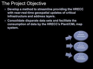
- 29. The Project ObjectiveDevelop a method to streamline providing the HRECC with near-real-time geospatial updates of critical infrastructure and address layers.
- 30. Consolidate disparate data sets and facilitate the consumption of data by the HRECCŌĆÖs Plant/CML map system.9-1-1DispatchWorkstation9-1-1DispatchWorkstation9-1-1DispatchWorkstation
- 31. The Project ApproachSecure an industry aware GIS consultant to analyze the local GIS Divisions and determine best method for automated data transfer and integration.
- 32. Establish a private, secure network between the HRECC, Rockingham County and Harrisonburg.
- 33. Collaborate with Plant/CML to develop a procedure for data input into the HRECC mapping solution.
- 34. Design, test and optimize the system.
- 35. The Project ApproachResearch and understand the problem!
- 36. Organize a project team among the localities, the HRECC, the consultant, and the Virginia Geographic Information Network (VGIN)
- 37. Create a Functional Requirements Document!
- 39. Outline the current state and the target state
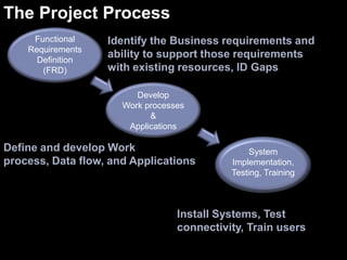
- 40. Determine potential uses of the proposed technology by or among other 9-1-1 call centers and VGIN.The Project ProcessFunctionalRequirementsDefinition(FRD)Identify the Business requirements and ability to support those requirements with existing resources, ID GapsDevelopWork processes&ApplicationsDefine and develop Work process, Data flow, and ApplicationsSystemImplementation, Testing, TrainingInstall Systems, Test connectivity, Train users
- 41. Determining User Requirements4 Areas of Requirements FocusDataWorkflowSoftware ApplicationsSystem Infrastructure
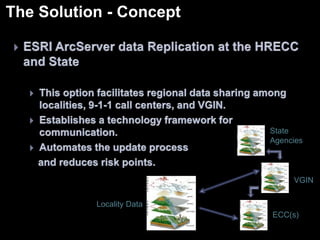
- 42. The Solution - ConceptESRI ArcServer data Replication at the HRECC and State
- 43. This option facilitates regional data sharing among localities, 9-1-1 call centers, and VGIN.
- 44. Establishes a technology framework for communication.
- 45. Automates the update process and reduces risk points.StateAgencies VGINLocality DataECC(s)
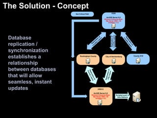
- 46. The Solution - ConceptDatabase replication / synchronization establishes a relationship between databases that will allow seamless, instant updates
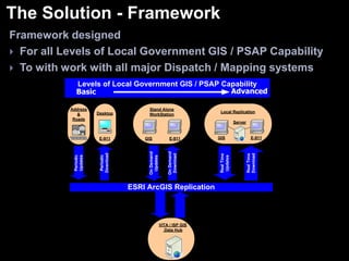
- 47. The Solution - FrameworkFramework designed For all Levels of Local Government GIS / PSAP CapabilityTo with work with all major Dispatch / Mapping systems
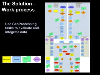
- 48. The Solution ŌĆō Work processUse GeoProcessing tasks to evaluate and integrate data
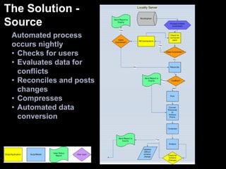
- 49. The Solution - SourceAutomated process occurs nightlyChecks for users
- 50. Evaluates data for conflicts
- 51. Reconciles and posts changes
- 52. Compresses
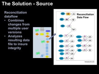
- 53. Automated data conversionThe Solution - SourceReconciliation dataflowCombines changes from multiple user versions
- 54. Analyzes resulting data file to insure integrityReconciliation Data Flow
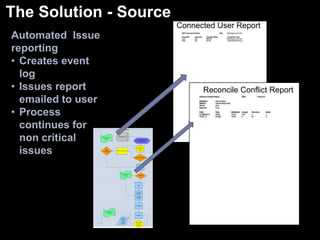
- 55. The Solution - SourceConnected User ReportAutomated Issue reportingCreates event log
- 56. Issues report emailed to user
- 57. Process continues for non critical issuesReconcile Conflict Report
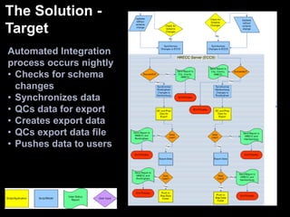
- 58. The Solution - TargetAutomated Integration process occurs nightlyChecks for schema changes
- 60. QCs data for export
- 62. QCs export data file
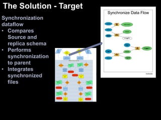
- 63. Pushes data to usersThe Solution - TargetSynchronize Data FlowSynchronization dataflowCompares Source and replica schema
- 64. Performs synchronization to parent
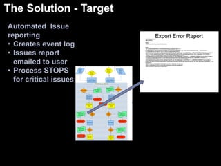
- 65. Integrates synchronized filesThe Solution - TargetAutomated Issue reportingCreates event log
- 66. Issues report emailed to user
- 67. Process STOPS for critical issuesExport Error Report
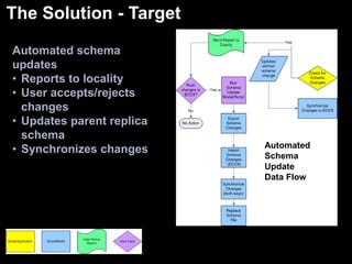
- 68. The Solution - TargetAutomated schema updatesReports to locality
- 70. Updates parent replica schema
- 71. Synchronizes changesAutomated Schema UpdateData Flow
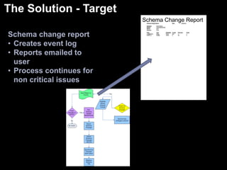
- 72. The Solution - TargetSchema Change ReportSchema change reportCreates event log
- 73. Reports emailed to user
- 74. Process continues for non critical issuesThe Solution - ConnectivityMaximized use of Existing Systems Infrastructure
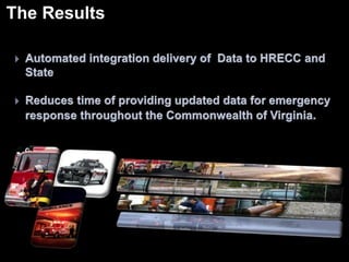
- 75. The ResultsAutomated integration delivery of Data to HRECC and State
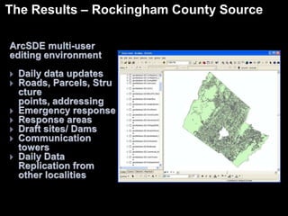
- 76. Reduces time of providing updated data for emergency response throughout the Commonwealth of Virginia.The Results ŌĆō Rockingham County SourceArcSDE multi-user editing environmentDaily data updates
- 77. Roads, Parcels, Structure points, addressing
- 79. Response areas
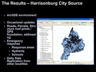
- 82. Daily Data Replication from other localities The Results ŌĆō Harrisonburg City SourceArcSDE environment
- 84. Roads, Parcels, Structure roof prints / GPS foundation, addressing
- 86. Response areas
- 87. Hydrants
- 88. Schools
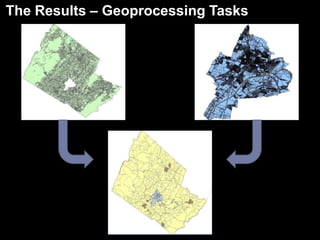
- 89. Daily Data Replication from other localities The Results ŌĆō Geoprocessing Tasks
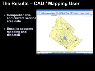
- 90. The Results ŌĆō CAD / Mapping UserComprehensive and current service area data
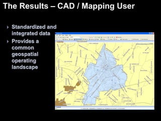
- 91. Enables accurate mapping and dispatch The Results ŌĆō CAD / Mapping UserStandardized and integrated data
- 92. Provides a common geospatial operating landscapeThe Results ŌĆō CAD / Mapping UserData updates from each source are added daily
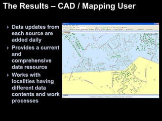
- 93. Provides a current and comprehensive data resource
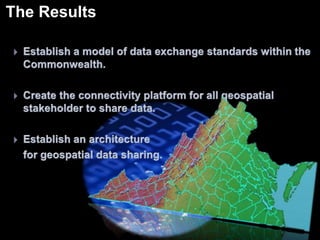
- 94. Works with localities having different data contents and work processesThe ResultsEstablish a model of data exchange standards within the Commonwealth.
- 95. Create the connectivity platform for all geospatial stakeholder to share data.
- 96. Establish an architecture for geospatial data sharing.
- 97. Questions ?To Support the Harrisonburg Rockingham Emergency Communications Center and the Commonwealth of Virginia