Town planning ppt
- 1. “A cityshould be built to give its inhabitants” “A place where men had a inhabitants securityand happiness” – Aristotle TOWN PLANNING CHARLIE GUPTA B.ARCH VIII-SEM SDCA GHAZIABAD SUBMITTED TO- AR. TARUN GAUTAM
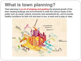
- 2. What is town planning? Town planning is an art of shaping and guiding the physical growth of the town creating buildings and environments to meet the various needs of the public such as social, cultural, economic and recreational etc. and to provide healthy conditions for both rich and poor to live, to work and to play or relax.
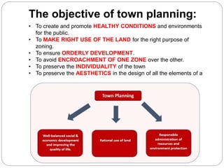
- 3. ? To create and promote HEALTHY CONDITIONS and environments for the public. ? To MAKE RIGHT USE OF THE LAND for the right purpose of zoning. ? To ensure ORDERLY DEVELOPMENT. ? To avoid ENCROACHMENT OF ONE ZONE over the other. ? To preserve the INDIVIDUALITY of the town ? To preserve the AESTHETICS in the design of all the elements of a town or a city plan. The objective of town planning:
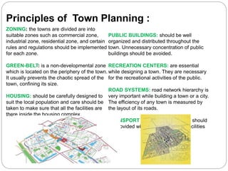
- 4. ZONING: the towns are divided are into suitable zones such as commercial zone, industrial zone, residential zone, and certain rules and regulations should be implemented for each zone. GREEN-BELT: is a non-developmental zone which is located on the periphery of the town. It usually prevents the chaotic spread of the town, confining its size. HOUSING: should be carefully designed to suit the local population and care should be taken to make sure that all the facilities are there inside the housing complex. PUBLIC BUILDINGS: should be well organized and distributed throughout the town. Unnecessary concentration of public buildings should be avoided. RECREATION CENTERS: are essential while designing a town. They are necessary for the recreational activities of the public. ROAD SYSTEMS: road network hierarchy is very important while building a town or a city. The efficiency of any town is measured by the layout of its roads. TRANSPORT FACILITIES: the town should be provided with suitable transport facilities Principles of Town Planning :
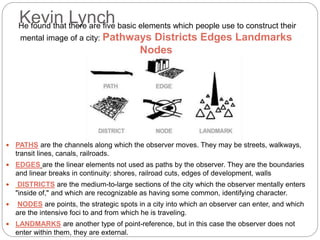
- 5. Kevin Lynch ? PATHS are the channels along which the observer moves. They may be streets, walkways, transit lines, canals, railroads. ? EDGES are the linear elements not used as paths by the observer. They are the boundaries and linear breaks in continuity: shores, railroad cuts, edges of development, walls ? DISTRICTS are the medium-to-large sections of the city which the observer mentally enters "inside of," and which are recognizable as having some common, identifying character. ? NODES are points, the strategic spots in a city into which an observer can enter, and which are the intensive foci to and from which he is traveling. ? LANDMARKS are another type of point-reference, but in this case the observer does not enter within them, they are external. He found that there are five basic elements which people use to construct their mental image of a city: Pathways Districts Edges Landmarks Nodes
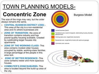
- 6. TOWN PLANNING MODELS- Concentric Zone The size of the rings may vary, but the order always remains the same. ? CENTRAL BUSINESS DISTRICT (CBD) - This area of the city is a non-residential area and it’s where businesses are ? ZONE OF TRANSITION- the zone of transition contains industry and has poorer-quality housing available. Created by subdividing larger houses into apartments ? ZONE OF THE WORKING CLASS- This area contains modest older houses occupied by stable, working-class families. A large percentage of the people in this area rent. ? ZONE OF BETTER RESIDENCE- This zone contains newer and more spacious houses. ? COMMUTER’S ZONE/SUBURBS- This area is located beyond the build-up area of the city.
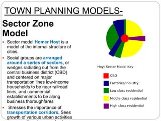
- 7. TOWN PLANNING MODELS- Sector Zone Model ? Sector model Homer Hoyt is a model of the internal structure of cities. ? Social groups are arranged around a series of sectors, or wedges radiating out from the central business district (CBD) and centered on major transportation lines low-income households to be near railroad lines, and commercial establishments to be along business thoroughfares ? Stresses the importance of transportation corridors. Sees growth of various urban activities
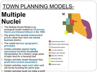
- 8. TOWN PLANNING MODELS- Multiple Nuclei ? The Multiple Nuclei Model is an ecological model created by Chauncey Harris and Edward Ullman in the 1945 ? City grows from several independent points rather than from one central business district.. ? The model has four geographic principles ? Certain activities require highly specialized facilities-Accessible transportation for a factory Large areas of open land for a housing tract ? Certain activities cluster because they profit from mutual association ? Certain activities repel each other and will not be founding the same area ? Certain activities could not make a profit
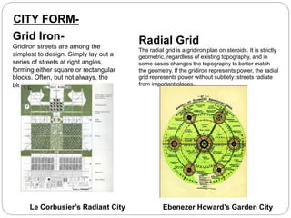
- 9. Grid Iron- Gridiron streets are among the simplest to design. Simply lay out a series of streets at right angles, forming either square or rectangular blocks. Often, but not always, the blocks are all the same size. Radial Grid The radial grid is a gridiron plan on steroids. It is strictly geometric, regardless of existing topography, and in some cases changes the topography to better match the geometry. If the gridiron represents power, the radial grid represents power without subtlety: streets radiate from important places. Ebenezer Howard’s Garden CityLe Corbusier’s Radiant City CITY FORM-
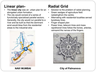
- 10. Linear plan- ? The linear city was an urban plan for an elongated urban formation. ? The city would consist of a series of functionally specialized parallel sectors. Generally, the city would run parallel to a river and be built so that the dominant wind would blow from the residential areas to the industrial strip Radial Grid ? Solution to the problem of radial planning. ? Green wedges of agriculture field radiatingfrom the centre. ? Alternating with residential localities served byrailway lines. ? Finger shaped plan ? Power lines, telecom lines and mass rapidtransit lines follow the bones, arteries, veinsand the nerves of the fingers. NAVI MUMBAI City of Palmanova
