urban planning application of GIS COURSE 6 GIS- PLANNING.ppt
Download as ppt, pdf0 likes45 views
GIS applications in urban planning facilitate various tasks such as area monitoring, site selection, and land-use policy formulation. They enable the creation of predictive models for land-use changes, which aid in environmental planning and impact assessments. Additionally, GIS is essential for wetland management and provides valuable data through satellite imagery for resource inventory and analysis.
1 of 9
Download to read offline

Ad
Recommended
Application of gis in urban planning
Application of gis in urban planningWESLEY MELI
╠²
GIS technology is useful for urban planning by helping to analyze urban growth and identify suitable sites for development based on factors like accessibility, topography, land use, and water resources. GIS can be used to create resource inventories by integrating remote sensing data, analyze existing urban situations through overlay analysis, model and project future population changes, develop planning options through land suitability maps and spatial optimization, help select options through multi-criteria analysis, and aid in plan implementation through environmental impact assessments. In summary, GIS is crucial for sustainable urban development and economic growth by allowing rapid updating of data layers and assessment of land use changes over time to inform better urban planning.INTRODUCTION TO GIS AND GEOREFRENCING.pptx
INTRODUCTION TO GIS AND GEOREFRENCING.pptxMEGHANA S
╠²
The document introduces Geographic Information Systems (GIS) and its applications in various fields such as urban planning, agriculture, disaster management, and telecommunications. It highlights the importance of GIS in architectural education and its role in analyzing spatial data for effective decision-making. Additionally, the document discusses the process of creating contour maps, georeferencing, and digitization in GIS.Geographic information system (GIS) and its application in precision farming
Geographic information system (GIS) and its application in precision farmingDr. M. Kumaresan
╠²
Geographic information system (GIS) and its application in precision farming. GIS integrates hardware, software, and data for capturing, managing, analyzing, and displaying all forms of geographically referenced information. GIS is important for precision horticulture as it allows farmers to analyze spatial data on elevation, soil properties, climate and natural factors to make informed decisions on crop planning and management.Environment Impact Assessment Using Remote Sensing
Environment Impact Assessment Using Remote Sensingshubham shama
╠²
This document provides an overview of using remote sensing and GIS for environmental impact assessments. It discusses how satellite imagery allows for large area coverage in short time periods and how GIS enables spatial analysis and modeling. Examples are given of assessing impacts of projects like dams by computing command areas and changes over time. Both active sensors like radar and lidar, and passive sensors like radiometers are outlined. The advantages of remote sensing for environmental monitoring and assessing rapidly changing phenomena are highlighted.Lecture 1_ Intro n Basics_GIS.pptx
Lecture 1_ Intro n Basics_GIS.pptxnobelhasssan
╠²
This document provides an overview of a Geographic Information Systems (GIS) course. It defines GIS as a computer tool that combines database and mapping technologies to create maps where every point, line, or polygon is connected to a database. GIS allows users to spend time reviewing, understanding, querying, and classifying geospatial data to solve problems with a spatial component. The document also outlines the key components, applications, related technologies, benefits, and basic functions of GIS systems.GIS Application Used in Urban Planning In India
GIS Application Used in Urban Planning In IndiaIRJET Journal
╠²
This document discusses how geographic information systems (GIS) are used for urban planning in India. It provides an overview of GIS, describing it as a system for capturing, storing, analyzing, and managing spatially referenced data. GIS allows users to create maps, perform spatial queries and analysis, and visualize and model information. The document outlines how GIS is used in various aspects of urban planning like infrastructure development, transportation planning, and monitoring of health, sanitation, and other city services. It provides examples of how GIS aids in tasks like feasibility studies, land use planning, and public participation in the planning process. Overall, the document illustrates how Indian planners leverage GIS technologies to effectively plan and manage urban development.Introduction to gis and its application
Introduction to gis and its application gandhinagar
╠²
This document introduces Geographic Information Systems (GIS) and describes its components and applications. GIS is a collection of software, hardware, data, and personnel used to store, manipulate, analyze and present geospatial data. Its major objectives are to maximize efficiency, integrate multiple data sources, enable complex analysis, and minimize redundant data. A GIS has hardware, software, data, procedures, and personnel. It then discusses applications of GIS in transportation, water resource engineering, urban planning, construction, and analysis.Application of GIS (Geographical information system)
Application of GIS (Geographical information system)Fayaz Ahamed A P
╠²
This document discusses the applications of Geographic Information Systems (GIS). It begins by defining GIS as a collection of software, hardware, data, and personnel used to store, manipulate, analyze and present geographically referenced information. It then lists some key applications of GIS in transportation, water resource engineering, urban planning, construction, and analysis. For each application area, 1-2 examples are provided to illustrate how GIS can be used, such as analyzing transportation infrastructure and planning, modeling watershed areas and reservoir volumes for dam construction, integrating spatial and attribute data for urban planning, and performing various analyses to support design and management of infrastructure projects.GIS in Urban Planning and development of region.pdf
GIS in Urban Planning and development of region.pdfMayankyadav578189
╠²
The document discusses the applications of Geographic Information Systems (GIS) in urban planning, highlighting its role as a spatial database and analysis tool. GIS supports effective decision-making in urban planning through data retrieval, spatial analysis, and resource inventory management, aiding tasks like land suitability and impact assessments. Additionally, it enables simulation of different development scenarios, assisting planners in formulating optimal planning options.GIS in Urban Planning and its applications .pdf
GIS in Urban Planning and its applications .pdfMayankyadav578189
╠²
Geographic Information Systems (GIS) are crucial in urban planning, acting as both a spatial database and a modeling tool for planners to analyze and improve decision-making. GIS applications include spatial analysis, site selection, and land suitability analysis, allowing for efficient resource inventory and environmental impact assessments. The integration of varied data sources enhances planning efficiency, supports scenario modeling, and aids in the identification of development conflicts and optimization of planning options.DIGITIZATION OF CITIES ON GIS PLATFORM.pdf
DIGITIZATION OF CITIES ON GIS PLATFORM.pdfHimanshuDeshmukh32
╠²
This document discusses how to digitize an entire city using GIS-based software to provide a "one touch solution" for representing multiple data types that can be used by government organizations. It outlines the key steps: 1) setting up DGPS control points, 2) conducting a total station survey, 3) performing a drone survey to create a 3D digital model, and 4) processing the data in GIS. Examples are given of the types of information that can be stored in GIS layers and applications of GIS in areas like urban planning, environmental impact analysis, agriculture, and more.Application Of GIS In Environmental Engineering
Application Of GIS In Environmental EngineeringStephen Faucher
╠²
This document discusses the application of geographic information systems (GIS) in environmental engineering. It begins by providing background on GIS, explaining that GIS allows spatial data to be collected, analyzed, and used to make decisions about the environment. It then gives examples of how GIS can be used for environmental engineering tasks like mapping water pollution, assessing drought impacts, and monitoring floods. The document also outlines the basic process for a GIS analysis and discusses some key features of GIS that are useful for environmental engineers, such as mapping patterns and modeling "what if" scenarios. It concludes by providing examples of how GIS has been applied to tasks like environmental impact assessments and planning for/managing environmental hazards and risks.Gisapplicationincivilengineering 140227110022-phpapp02
Gisapplicationincivilengineering 140227110022-phpapp02Antriksh Vatsyayana
╠²
The document discusses how geographic information systems (GIS) can be used in various aspects of civil engineering. It provides definitions of GIS and describes how GIS allows storage, analysis, and visualization of spatial data. It then discusses specific applications of GIS in infrastructure management over the project lifecycle, including planning, design, construction, and operations/maintenance. Additional applications discussed include transportation, landfill site selection, watershed management, town planning, and critical infrastructure protection.ASSESSMENT OF URBAN DYNAMICS IN LAND USE AND DEMOGRPAHY USING GIS TECHNIQUES
ASSESSMENT OF URBAN DYNAMICS IN LAND USE AND DEMOGRPAHY USING GIS TECHNIQUESIRJET Journal
╠²
This document summarizes a study that assesses urban dynamics related to land use and demography using GIS techniques. The study examines literature and case studies from national and international contexts to identify models, methods, and approaches for analyzing urban growth and land use patterns. Key indicators related to land use changes and population density are identified. The study also explores the use of tools like GIS, remote sensing, GPS, and modeling to analyze land use patterns and forecast future scenarios to inform urban planning and management strategies. The conclusion highlights the importance of adapting sustainable urbanization strategies that consider the spatial and temporal scale of change.Gis application in civil engineering
Gis application in civil engineeringAmal C Varghese
╠²
The document provides an overview of how geographic information systems (GIS) can be used in civil engineering applications. It discusses how GIS allows civil engineers to manage and analyze spatial data to support infrastructure planning, design, construction, and maintenance. It also summarizes several specific ways GIS is used, including infrastructure management, transportation, land use planning, watershed management, and environmental analysis. GIS provides a centralized way to store and visualize spatial data, analyze relationships, and share information across teams and organizations.GEOGRAPHIC INFORMATION SYSTEM.pptx
GEOGRAPHIC INFORMATION SYSTEM.pptxFizaNaaz8
╠²
This document provides information about Geographic Information Systems (GIS) including what GIS is, its applications, data types used, and importance in architecture. GIS refers to interconnected hardware, software, users, data, and procedures that together enable geospatial analysis. It is used for tasks like mapping locations and quantities, finding distances, and monitoring change over time. GIS uses vector data represented as points, lines, and polygons with coordinate pairs. It has various applications in fields like urban planning, utilities management, and transportation planning. The document also outlines how GIS can be used in architecture for tasks such as line of sight planning, noise exposure modeling, and solar exposure analysis.GISgIRR G1.pptx
GISgIRR G1.pptxGirmaDubale
╠²
This document outlines the development of a GIS-based irrigation management system designed for irrigation consortia and local governments, enabling the evaluation of irrigation scenarios based on various conditions. It highlights the system's capabilities to integrate spatial data and customize applications for water management, utilizing ArcView GIS and Avenue programming. Additionally, it discusses the importance of GIS in decision-making, agricultural planning, and natural resource management.Gis dr rahul
Gis dr rahulDrrahul Shrivastava
╠²
This document provides an overview of geographic information systems (GIS) and their applications in public health. It discusses the history and development of GIS from the earliest uses in epidemiology in the 1800s to modern digital systems. Key aspects of GIS covered include data representation methods, uncertainties, terminology, and limitations. The document also outlines several important uses of GIS in public health such as mapping disease distribution and identifying at-risk populations.GIS
GISParth Patel
╠²
A geographic information system (GIS) is a system used to capture, store, manipulate, analyze, and present geographical data. GIS integrates cartography, statistical analysis, and computer science to allow users to create interactive maps, analyze spatial information, and make decisions based on the results. GIS represents real-world objects digitally and stores data in vector or raster formats. It can analyze spatial relationships, model hydrological and transportation networks, perform map overlays, and support decision-making across many fields.application of gis rs in urban planninggem
application of gis rs in urban planninggemRanjitZende2
╠²
The document discusses the application of remote sensing and geographic information systems (GIS) in urban planning, highlighting their role in acquiring spatial, spectral, and temporal data efficiently. It outlines various uses of these technologies such as urban land use mapping, environmental monitoring, and planning based on data analysis. The conclusion emphasizes the necessity of timely and reliable information for addressing challenges posed by rapid urbanization.Application of gis & rs in urban planning
Application of gis & rs in urban planning sathish1446
╠²
Remote sensing uses sensors aboard satellites or aircraft to acquire spatial, spectral and temporal data about objects without physical contact. This data is digitized and processed into images. GIS is a system that integrates hardware, software and data to capture, store, analyze and display spatial or geographic information. Remote sensing and GIS are useful tools for urban planning applications such as land use/cover mapping, environmental monitoring, updating basemaps, studying urban growth, transportation systems, and site suitability analysis. GIS allows for overlaying of maps, buffering, and route analysis to support zoning, land management, emergency response and other planning needs. Together, remote sensing and GIS provide timely, reliable spatial data and analysis functions for addressing challengesGis applications & Implement
Gis applications & ImplementRAQIBSTELEGRAPH
╠²
Geographic Information Systems (GIS) integrate hardware, software, and data to manage and analyze geospatial information for various fields, including urban management, land resources, and environmental applications. GIS plays a crucial role in improving decision-making in areas such as transportation planning, agriculture, public safety, and economic development. The technology supports efficient resource management, zoning, environmental monitoring, and business growth through comprehensive data analysis and visualization.gis_disciplines.pdf
gis_disciplines.pdf3129PriyaParmar
╠²
The document discusses how GIS is used across multiple disciplines including archaeology, economics, biology/ecology, political science, public administration, nursing/health, geology, history, environmental studies, engineering, and geography. GIS provides spatial analysis and mapping capabilities that help researchers, policymakers, and organizations understand patterns and make informed decisions in their respective fields.Application of gis for forest study
Application of gis for forest studymeengistu adane
╠²
This document provides information about the use of Geographic Information Systems (GIS) in forest management. It discusses how GIS tools can be used to capture, store, analyze and present geospatial data. GIS allows forest managers to model and map forests, predict future conditions under different management scenarios, plan harvests and fires, and incorporate other spatial data like infrastructure, boundaries and terrain. The document concludes that as environmental issues grow in complexity, GIS will continue playing a key role in botanical science and sustainable forest management by facilitating the analysis of highly variable spatial and temporal data.Applications of gis
Applications of gisPRAMODA G
╠²
This document discusses the various applications of geographic information systems (GIS). It begins by introducing GIS and its capabilities, such as data input, management, analysis and modeling. It then examines 10 specific applications of GIS: 1) geological mapping, 2) mining and mineral exploration, 3) groundwater exploration, 4) environmental analysis, 5) disaster management, 6) transportation systems, 7) demographic analysis, 8) agricultural development, 9) forestry, and 10) tourism. For each application, it provides details on how GIS is used to analyze spatial data, facilitate decision making, and support planning and management activities.Applications of gis
Applications of gisPRAMODA G
╠²
This document discusses the various applications of geographic information systems (GIS). It begins by introducing GIS and its capabilities, such as data input, management, analysis and modeling. It then examines 10 specific applications of GIS: 1) geological mapping, 2) mining and mineral exploration, 3) groundwater exploration, 4) environmental analysis, 5) disaster management, 6) transportation systems, 7) demographic analysis, 8) agricultural development, 9) forestry, and 10) tourism. For each application, it provides details on how GIS is used to input, store, analyze and output geospatial data to support decision making in that domain.Gis applications
Gis applicationsKisesa Hamis
╠²
This document provides summaries of various applications of GIS technology across different domains:
1) GIS is used for urban planning to analyze urban growth and expansion and identify suitable sites for development based on factors like accessibility, land flatness, current usage and water supply.
2) GIS provides mapping functionality and allows non-cartographers to visually represent data on maps. Examples include Google Maps, Bing Maps and Yahoo Maps.
3) GIS helps monitor coal mine safety and identify risks of spontaneous combustion fires.
4) GIS supports business applications like customer tracking, site selection, marketing and optimizing sales territories.
5) GIS is useful for public health applications like evaluating health policies, studying relationships betweenVitamin and Nutritional Deficiencies.pptx
Vitamin and Nutritional Deficiencies.pptxVishal Chanalia
╠²
Vitamin and nutritional deficiency occurs when the body does not receive enough essential nutrients, such as vitamins and minerals, needed for proper functioning. This can lead to various health problems, including weakened immunity, stunted growth, fatigue, poor wound healing, cognitive issues, and increased susceptibility to infections and diseases. Long-term deficiencies can cause serious and sometimes irreversible health complications.Great Governors' Send-Off Quiz 2025 Prelims IIT KGP
Great Governors' Send-Off Quiz 2025 Prelims IIT KGPIIT Kharagpur Quiz Club
╠²
Prelims of the Great Governors' Send-Off Quiz 2025 hosted by the outgoing governors.
QMs: Aarushi, Aatir, Aditya, ArnavMore Related Content
Similar to urban planning application of GIS COURSE 6 GIS- PLANNING.ppt (20)
Application of GIS (Geographical information system)
Application of GIS (Geographical information system)Fayaz Ahamed A P
╠²
This document discusses the applications of Geographic Information Systems (GIS). It begins by defining GIS as a collection of software, hardware, data, and personnel used to store, manipulate, analyze and present geographically referenced information. It then lists some key applications of GIS in transportation, water resource engineering, urban planning, construction, and analysis. For each application area, 1-2 examples are provided to illustrate how GIS can be used, such as analyzing transportation infrastructure and planning, modeling watershed areas and reservoir volumes for dam construction, integrating spatial and attribute data for urban planning, and performing various analyses to support design and management of infrastructure projects.GIS in Urban Planning and development of region.pdf
GIS in Urban Planning and development of region.pdfMayankyadav578189
╠²
The document discusses the applications of Geographic Information Systems (GIS) in urban planning, highlighting its role as a spatial database and analysis tool. GIS supports effective decision-making in urban planning through data retrieval, spatial analysis, and resource inventory management, aiding tasks like land suitability and impact assessments. Additionally, it enables simulation of different development scenarios, assisting planners in formulating optimal planning options.GIS in Urban Planning and its applications .pdf
GIS in Urban Planning and its applications .pdfMayankyadav578189
╠²
Geographic Information Systems (GIS) are crucial in urban planning, acting as both a spatial database and a modeling tool for planners to analyze and improve decision-making. GIS applications include spatial analysis, site selection, and land suitability analysis, allowing for efficient resource inventory and environmental impact assessments. The integration of varied data sources enhances planning efficiency, supports scenario modeling, and aids in the identification of development conflicts and optimization of planning options.DIGITIZATION OF CITIES ON GIS PLATFORM.pdf
DIGITIZATION OF CITIES ON GIS PLATFORM.pdfHimanshuDeshmukh32
╠²
This document discusses how to digitize an entire city using GIS-based software to provide a "one touch solution" for representing multiple data types that can be used by government organizations. It outlines the key steps: 1) setting up DGPS control points, 2) conducting a total station survey, 3) performing a drone survey to create a 3D digital model, and 4) processing the data in GIS. Examples are given of the types of information that can be stored in GIS layers and applications of GIS in areas like urban planning, environmental impact analysis, agriculture, and more.Application Of GIS In Environmental Engineering
Application Of GIS In Environmental EngineeringStephen Faucher
╠²
This document discusses the application of geographic information systems (GIS) in environmental engineering. It begins by providing background on GIS, explaining that GIS allows spatial data to be collected, analyzed, and used to make decisions about the environment. It then gives examples of how GIS can be used for environmental engineering tasks like mapping water pollution, assessing drought impacts, and monitoring floods. The document also outlines the basic process for a GIS analysis and discusses some key features of GIS that are useful for environmental engineers, such as mapping patterns and modeling "what if" scenarios. It concludes by providing examples of how GIS has been applied to tasks like environmental impact assessments and planning for/managing environmental hazards and risks.Gisapplicationincivilengineering 140227110022-phpapp02
Gisapplicationincivilengineering 140227110022-phpapp02Antriksh Vatsyayana
╠²
The document discusses how geographic information systems (GIS) can be used in various aspects of civil engineering. It provides definitions of GIS and describes how GIS allows storage, analysis, and visualization of spatial data. It then discusses specific applications of GIS in infrastructure management over the project lifecycle, including planning, design, construction, and operations/maintenance. Additional applications discussed include transportation, landfill site selection, watershed management, town planning, and critical infrastructure protection.ASSESSMENT OF URBAN DYNAMICS IN LAND USE AND DEMOGRPAHY USING GIS TECHNIQUES
ASSESSMENT OF URBAN DYNAMICS IN LAND USE AND DEMOGRPAHY USING GIS TECHNIQUESIRJET Journal
╠²
This document summarizes a study that assesses urban dynamics related to land use and demography using GIS techniques. The study examines literature and case studies from national and international contexts to identify models, methods, and approaches for analyzing urban growth and land use patterns. Key indicators related to land use changes and population density are identified. The study also explores the use of tools like GIS, remote sensing, GPS, and modeling to analyze land use patterns and forecast future scenarios to inform urban planning and management strategies. The conclusion highlights the importance of adapting sustainable urbanization strategies that consider the spatial and temporal scale of change.Gis application in civil engineering
Gis application in civil engineeringAmal C Varghese
╠²
The document provides an overview of how geographic information systems (GIS) can be used in civil engineering applications. It discusses how GIS allows civil engineers to manage and analyze spatial data to support infrastructure planning, design, construction, and maintenance. It also summarizes several specific ways GIS is used, including infrastructure management, transportation, land use planning, watershed management, and environmental analysis. GIS provides a centralized way to store and visualize spatial data, analyze relationships, and share information across teams and organizations.GEOGRAPHIC INFORMATION SYSTEM.pptx
GEOGRAPHIC INFORMATION SYSTEM.pptxFizaNaaz8
╠²
This document provides information about Geographic Information Systems (GIS) including what GIS is, its applications, data types used, and importance in architecture. GIS refers to interconnected hardware, software, users, data, and procedures that together enable geospatial analysis. It is used for tasks like mapping locations and quantities, finding distances, and monitoring change over time. GIS uses vector data represented as points, lines, and polygons with coordinate pairs. It has various applications in fields like urban planning, utilities management, and transportation planning. The document also outlines how GIS can be used in architecture for tasks such as line of sight planning, noise exposure modeling, and solar exposure analysis.GISgIRR G1.pptx
GISgIRR G1.pptxGirmaDubale
╠²
This document outlines the development of a GIS-based irrigation management system designed for irrigation consortia and local governments, enabling the evaluation of irrigation scenarios based on various conditions. It highlights the system's capabilities to integrate spatial data and customize applications for water management, utilizing ArcView GIS and Avenue programming. Additionally, it discusses the importance of GIS in decision-making, agricultural planning, and natural resource management.Gis dr rahul
Gis dr rahulDrrahul Shrivastava
╠²
This document provides an overview of geographic information systems (GIS) and their applications in public health. It discusses the history and development of GIS from the earliest uses in epidemiology in the 1800s to modern digital systems. Key aspects of GIS covered include data representation methods, uncertainties, terminology, and limitations. The document also outlines several important uses of GIS in public health such as mapping disease distribution and identifying at-risk populations.GIS
GISParth Patel
╠²
A geographic information system (GIS) is a system used to capture, store, manipulate, analyze, and present geographical data. GIS integrates cartography, statistical analysis, and computer science to allow users to create interactive maps, analyze spatial information, and make decisions based on the results. GIS represents real-world objects digitally and stores data in vector or raster formats. It can analyze spatial relationships, model hydrological and transportation networks, perform map overlays, and support decision-making across many fields.application of gis rs in urban planninggem
application of gis rs in urban planninggemRanjitZende2
╠²
The document discusses the application of remote sensing and geographic information systems (GIS) in urban planning, highlighting their role in acquiring spatial, spectral, and temporal data efficiently. It outlines various uses of these technologies such as urban land use mapping, environmental monitoring, and planning based on data analysis. The conclusion emphasizes the necessity of timely and reliable information for addressing challenges posed by rapid urbanization.Application of gis & rs in urban planning
Application of gis & rs in urban planning sathish1446
╠²
Remote sensing uses sensors aboard satellites or aircraft to acquire spatial, spectral and temporal data about objects without physical contact. This data is digitized and processed into images. GIS is a system that integrates hardware, software and data to capture, store, analyze and display spatial or geographic information. Remote sensing and GIS are useful tools for urban planning applications such as land use/cover mapping, environmental monitoring, updating basemaps, studying urban growth, transportation systems, and site suitability analysis. GIS allows for overlaying of maps, buffering, and route analysis to support zoning, land management, emergency response and other planning needs. Together, remote sensing and GIS provide timely, reliable spatial data and analysis functions for addressing challengesGis applications & Implement
Gis applications & ImplementRAQIBSTELEGRAPH
╠²
Geographic Information Systems (GIS) integrate hardware, software, and data to manage and analyze geospatial information for various fields, including urban management, land resources, and environmental applications. GIS plays a crucial role in improving decision-making in areas such as transportation planning, agriculture, public safety, and economic development. The technology supports efficient resource management, zoning, environmental monitoring, and business growth through comprehensive data analysis and visualization.gis_disciplines.pdf
gis_disciplines.pdf3129PriyaParmar
╠²
The document discusses how GIS is used across multiple disciplines including archaeology, economics, biology/ecology, political science, public administration, nursing/health, geology, history, environmental studies, engineering, and geography. GIS provides spatial analysis and mapping capabilities that help researchers, policymakers, and organizations understand patterns and make informed decisions in their respective fields.Application of gis for forest study
Application of gis for forest studymeengistu adane
╠²
This document provides information about the use of Geographic Information Systems (GIS) in forest management. It discusses how GIS tools can be used to capture, store, analyze and present geospatial data. GIS allows forest managers to model and map forests, predict future conditions under different management scenarios, plan harvests and fires, and incorporate other spatial data like infrastructure, boundaries and terrain. The document concludes that as environmental issues grow in complexity, GIS will continue playing a key role in botanical science and sustainable forest management by facilitating the analysis of highly variable spatial and temporal data.Applications of gis
Applications of gisPRAMODA G
╠²
This document discusses the various applications of geographic information systems (GIS). It begins by introducing GIS and its capabilities, such as data input, management, analysis and modeling. It then examines 10 specific applications of GIS: 1) geological mapping, 2) mining and mineral exploration, 3) groundwater exploration, 4) environmental analysis, 5) disaster management, 6) transportation systems, 7) demographic analysis, 8) agricultural development, 9) forestry, and 10) tourism. For each application, it provides details on how GIS is used to analyze spatial data, facilitate decision making, and support planning and management activities.Applications of gis
Applications of gisPRAMODA G
╠²
This document discusses the various applications of geographic information systems (GIS). It begins by introducing GIS and its capabilities, such as data input, management, analysis and modeling. It then examines 10 specific applications of GIS: 1) geological mapping, 2) mining and mineral exploration, 3) groundwater exploration, 4) environmental analysis, 5) disaster management, 6) transportation systems, 7) demographic analysis, 8) agricultural development, 9) forestry, and 10) tourism. For each application, it provides details on how GIS is used to input, store, analyze and output geospatial data to support decision making in that domain.Gis applications
Gis applicationsKisesa Hamis
╠²
This document provides summaries of various applications of GIS technology across different domains:
1) GIS is used for urban planning to analyze urban growth and expansion and identify suitable sites for development based on factors like accessibility, land flatness, current usage and water supply.
2) GIS provides mapping functionality and allows non-cartographers to visually represent data on maps. Examples include Google Maps, Bing Maps and Yahoo Maps.
3) GIS helps monitor coal mine safety and identify risks of spontaneous combustion fires.
4) GIS supports business applications like customer tracking, site selection, marketing and optimizing sales territories.
5) GIS is useful for public health applications like evaluating health policies, studying relationships betweenRecently uploaded (20)
Vitamin and Nutritional Deficiencies.pptx
Vitamin and Nutritional Deficiencies.pptxVishal Chanalia
╠²
Vitamin and nutritional deficiency occurs when the body does not receive enough essential nutrients, such as vitamins and minerals, needed for proper functioning. This can lead to various health problems, including weakened immunity, stunted growth, fatigue, poor wound healing, cognitive issues, and increased susceptibility to infections and diseases. Long-term deficiencies can cause serious and sometimes irreversible health complications.Great Governors' Send-Off Quiz 2025 Prelims IIT KGP
Great Governors' Send-Off Quiz 2025 Prelims IIT KGPIIT Kharagpur Quiz Club
╠²
Prelims of the Great Governors' Send-Off Quiz 2025 hosted by the outgoing governors.
QMs: Aarushi, Aatir, Aditya, ArnavAprendendo Arquitetura Framework Salesforce - Dia 02
Aprendendo Arquitetura Framework Salesforce - Dia 02Mauricio Alexandre Silva
╠²
Aprendendo Arquitetura Framework Salesforce - Dia 02
INDUCTIVE EFFECT slide for first prof pharamacy students
INDUCTIVE EFFECT slide for first prof pharamacy studentsSHABNAM FAIZ
╠²
The inductive effect is the electron-withdrawing or electron-donating effect transmitted through sigma (Žā) bonds in a molecule due to differences in electronegativity between atoms.
---
¤ö╣ Definition:
The inductive effect is the permanent shifting of electrons in a sigma bond caused by the electronegativity difference of atoms, resulting in partial charges within the molecule.How to Customize Quotation Layouts in Odoo 18
How to Customize Quotation Layouts in Odoo 18Celine George
╠²
Customizing quotation layouts in Odoo 18 allows businesses to personalize their quotations to match branding or specific requirements. This can include adding logos, custom fields, or modifying headers and footers. THE PSYCHOANALYTIC OF THE BLACK CAT BY EDGAR ALLAN POE (1).pdf
THE PSYCHOANALYTIC OF THE BLACK CAT BY EDGAR ALLAN POE (1).pdfnabilahk908
╠²
Psychoanalytic Analysis of The Black Cat by Edgar Allan Poe explores the deep psychological dimensions of the narratorŌĆÖs disturbed mind through the lens of Sigmund FreudŌĆÖs psychoanalytic theory. According to Freud (1923), the human psyche is structured into three components: the Id, which contains primitive and unconscious desires; the Ego, which operates on the reality principle and mediates between the Id and the external world; and the Superego, which reflects internalized moral standards.
In this story, Poe presents a narrator who experiences a psychological breakdown triggered by repressed guilt, aggression, and internal conflict. This analysis focuses not only on the gothic horror elements of the narrative but also on the narratorŌĆÖs mental instability and emotional repression, demonstrating how the imbalance of these three psychic forces contributes to his downfall.Birnagar High School Platinum Jubilee Quiz.pptx
Birnagar High School Platinum Jubilee Quiz.pptxSourav Kr Podder
╠²
Birnagar High School Platinum Jubilee Celebration QuizUniversity of Ghana Cracks Down on Misconduct: Over 100 Students Sanctioned
University of Ghana Cracks Down on Misconduct: Over 100 Students SanctionedKweku Zurek
╠²
University of Ghana Cracks Down on Misconduct: Over 100 Students Sanctioned
Chalukyas of Gujrat, Solanki Dynasty NEP.pptx
Chalukyas of Gujrat, Solanki Dynasty NEP.pptxDr. Ravi Shankar Arya Mahila P. G. College, Banaras Hindu University, Varanasi, India.
╠²
This presentation has been made keeping in mind the students of undergraduate and postgraduate level. In this slide try to present the brief history of Chaulukyas of Gujrat up to Kumarpala To keep the facts in a natural form and to display the material in more detail, the help of various books, websites and online medium has been taken. Whatever medium the material or facts have been taken from, an attempt has been made by the presenter to give their reference at the end.
Chaulukya or Solanki was one of the Rajputs born from Agnikul. In the Vadnagar inscription, the origin of this dynasty is told from Brahma's Chauluk or Kamandalu. They ruled in Gujarat from the latter half of the tenth century to the beginning of the thirteenth century. Their capital was in Anahilwad. It is not certain whether it had any relation with the Chalukya dynasty of the south or not. It is worth mentioning that the name of the dynasty of the south was 'Chaluky' while the dynasty of Gujarat has been called 'Chaulukya'. The rulers of this dynasty were the supporters and patrons of Jainism.Peer Teaching Observations During School Internship
Peer Teaching Observations During School InternshipAjayaMohanty7
╠²
FOR B.ED,M.ED,M.A.EDUCATION AND ANY STUDENT OF TEACHER EDUCATIONRomanticism in Love and Sacrifice An Analysis of Oscar WildeŌĆÖs The Nightingal...
Romanticism in Love and Sacrifice An Analysis of Oscar WildeŌĆÖs The Nightingal...KaryanaTantri21
╠²
The story revolves around a college student who despairs not having a red rose as a condition for dancing with the girl he loves. The nightingale hears his complaint and offers to create the red rose at the cost of his life. He sang a love song all night with his chest stuck to the thorns of the rose tree. Finally, the red rose grew, but his sacrifice was in vain. The girl rejected the flower because it didnŌĆÖt match her outfit and preferred a jewellery gift. The student threw the flower on the street and returned to studying philosophyQ1_ENGLISH_PPT_WEEK 1 power point grade 3 Quarter 1 week 1
Q1_ENGLISH_PPT_WEEK 1 power point grade 3 Quarter 1 week 1jutaydeonne
╠²
Grade 3 Quarter 1 Week 1 English part 2F-BLOCK ELEMENTS POWER POINT PRESENTATIONS
F-BLOCK ELEMENTS POWER POINT PRESENTATIONSmprpgcwa2024
╠²
F-block elements are a group of elements in the periodic table that have partially filled f-orbitals. They are also known as inner transition elements. F-block elements are divided into two series:
1.Lanthanides (La- Lu) These elements are also known as rare earth elements.
2.Actinides (Ac- Lr): These elements are radioactive and have complex electronic configurations.
F-block elements exhibit multiple oxidation states due to the availability of f-orbitals.
2. Many f-block compounds are colored due to f-f transitions.
3. F-block elements often exhibit paramagnetic or ferromagnetic behavior.4. Actinides are radioactive.
F-block elements are used as catalysts in various industrial processes.
Actinides are used in nuclear reactors and nuclear medicine.
F-block elements are used in lasers and phosphors due to their luminescent properties.
F-block elements have unique electronic and magnetic properties.How payment terms are configured in Odoo 18
How payment terms are configured in Odoo 18Celine George
╠²
Payment terms in Odoo 18 help define the conditions for when invoices are due. This feature can split payments into multiple parts and automate due dates based on specific rules.Paper 107 | From Watchdog to Lapdog: IshiguroŌĆÖs Fiction and the Rise of ŌĆ£Godi...
Paper 107 | From Watchdog to Lapdog: IshiguroŌĆÖs Fiction and the Rise of ŌĆ£Godi...Rajdeep Bavaliya
╠²
Dive into a captivating analysis where Kazuo IshiguroŌĆÖs nuanced fiction meets the stark realities of postŌĆæ2014 Indian journalism. Uncover how ŌĆ£Godi MediaŌĆØ turned from watchdog to lapdog, echoing the moral compromises of IshiguroŌĆÖs protagonists. WeŌĆÖll draw parallels between restrained narrative silences and sensationalist headlinesŌĆöare our media heroes or traitors? DonŌĆÖt forget to follow for more deep dives!
M.A. Sem - 2 | Presentation
Presentation Season - 2
Paper - 107: The Twentieth Century Literature: From World War II to the End of the Century
Submitted Date: April 4, 2025
Paper Name: The Twentieth Century Literature: From World War II to the End of the Century
Topic: From Watchdog to Lapdog: IshiguroŌĆÖs Fiction and the Rise of ŌĆ£Godi MediaŌĆØ in Post-2014 Indian Journalism
[Please copy the link and paste it into any web browser to access the content.]
Video Link: https://youtu.be/kIEqwzhHJ54
For a more in-depth discussion of this presentation, please visit the full blog post at the following link: https://rajdeepbavaliya2.blogspot.com/2025/04/from-watchdog-to-lapdog-ishiguro-s-fiction-and-the-rise-of-godi-media-in-post-2014-indian-journalism.html
Please visit this blog to explore additional presentations from this season:
Hashtags:
#GodiMedia #Ishiguro #MediaEthics #WatchdogVsLapdog #IndianJournalism #PressFreedom #LiteraryCritique #AnArtistOfTheFloatingWorld #MediaCapture #KazuoIshiguro
Keyword Tags:
Godi Media, Ishiguro fiction, post-2014 Indian journalism, media capture, Kazuo Ishiguro analysis, watchdog to lapdog, press freedom India, media ethics, literature and media, An Artist of the Floating WorldOBSESSIVE COMPULSIVE DISORDER.pptx IN 5TH SEMESTER B.SC NURSING, 2ND YEAR GNM...
OBSESSIVE COMPULSIVE DISORDER.pptx IN 5TH SEMESTER B.SC NURSING, 2ND YEAR GNM...parmarjuli1412
╠²
OBSESSIVE COMPULSIVE DISORDER INCLUDED TOPICS ARE INTRODUCTION, DEFINITION OF OBSESSION, DEFINITION OF COMPULSION, MEANING OF OBSESSION AND COMPULSION, DEFINITION OF OBSESSIVE COMPULSIVE DISORDER, EPIDERMIOLOGY OF OCD, ETIOLOGICAL FACTORS OF OCD, CLINICAL SIGN AND SYMPTOMS OF OBSESSION AND COMPULSION, MANAGEMENT INCLUDED PHARMACOTHERAPY(ANTIDEPRESSANT DRUG+ANXIOLYTIC DRUGS), PSYCHOTHERAPY, NURSING MANAGEMENT(ASSESSMENT+DIAGNOSIS+NURSING INTERVENTION+EVALUATION)) Code Profiling in Odoo 18 - Odoo 18 ║▌║▌▀Żs
Code Profiling in Odoo 18 - Odoo 18 ║▌║▌▀ŻsCeline George
╠²
Profiling in Odoo identifies slow code and resource-heavy processes, ensuring better system performance. Odoo code profiling detects bottlenecks in custom modules, making it easier to improve speed and scalability.A Visual Introduction to the Prophet Jeremiah
A Visual Introduction to the Prophet JeremiahSteve Thomason
╠²
These images will give you a visual guide to both the context and the flow of the story of the prophet Jeremiah. Feel free to use these in your study, preaching, and teaching.Chalukyas of Gujrat, Solanki Dynasty NEP.pptx
Chalukyas of Gujrat, Solanki Dynasty NEP.pptxDr. Ravi Shankar Arya Mahila P. G. College, Banaras Hindu University, Varanasi, India.
╠²
Paper 107 | From Watchdog to Lapdog: IshiguroŌĆÖs Fiction and the Rise of ŌĆ£Godi...
Paper 107 | From Watchdog to Lapdog: IshiguroŌĆÖs Fiction and the Rise of ŌĆ£Godi...Rajdeep Bavaliya
╠²
Ad
urban planning application of GIS COURSE 6 GIS- PLANNING.ppt
- 1. Urban Planning Applications of GIS ŌĆó GIS can be applied to many types of problem. Among these are representatives of both raster and vector data base structures, both simple and complex analytical models. Master planning applications are one of them.
- 2. Urban Planning Applications of GIS ŌĆó Especially for area monitoring (both on a sectoral and integral basis), regional potential and feasibility analyses and site selection studies. For studies in which plan alternatives are generated, much more flexible design, optimization and evaluation tools would be needed in order to give GIS a dominant position in the development process.
- 3. Urban Planning Applications of GIS ŌĆó GIS can also be helpful for the documentation of spatial plans and in the approval process for the development, building and installation permits. ŌĆó GIS applied to a wide range of land management and land use planning issues including the interpretation and formulation of land use policy. Land-use policy can be interpreted within GIS using a modeling approach.
- 4. Urban Planning Applications of GIS ŌĆó Output in the form of maps showing areas in which land-use changes are more likely to occur, and statistics, graphs and tables summarizing this information according to a variety of specified spatial units. Such output allows land-use implications to be discussed. ŌĆó The predicted land-use changes can also form input for GIS-based impact assessment.
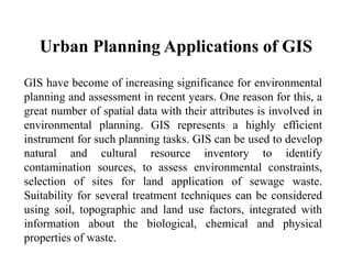
- 5. Urban Planning Applications of GIS GIS have become of increasing significance for environmental planning and assessment in recent years. One reason for this, a great number of spatial data with their attributes is involved in environmental planning. GIS represents a highly efficient instrument for such planning tasks. GIS can be used to develop natural and cultural resource inventory to identify contamination sources, to assess environmental constraints, selection of sites for land application of sewage waste. Suitability for several treatment techniques can be considered using soil, topographic and land use factors, integrated with information about the biological, chemical and physical properties of waste.
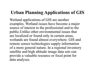
- 6. Urban Planning Applications of GIS Wetland applications of GIS are another examples. Wetland issues have become a major source of interest to the professional and to the public.Unlike other environmental issues that are localized or found only in certain areas, wetlands are found almost everywhere. GIS and remote sensor technologies supply information of a more general nature. In a regional inventory satellite and high altitude image data sets can provide a valuable resource or focal point for data analyses.