


More Related Content
Similar to VolcanoesII.ppt (20)
Recently uploaded (20)


![LABORATORY-AQUIRED INFECTION [Autosaved].pptx](https://cdn.slidesharecdn.com/ss_thumbnails/laboratory-aquiredinfectionautosaved-250315002051-ab8c0ae4-thumbnail.jpg?width=560&fit=bounds)


VolcanoesII.ppt
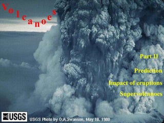
- 1. Impact of eruptions Vo l ca noe s Prediction Part II Supervolcanoes
- 2. Prediction of Volcanic Eruptions Identify volcanoes and the frequency and style of their eruptions (a geological problem). Long Term Prediction Establish the level of risk based on historic and geologic record. Establish probabilities of eruption, style and location for individual volcanoes. E.g., for individual volcanoes: determine most likely routes for lahars, nuees ardentes, lava flows, etc., and avoid construction in those areas.
- 3. Short-term prediction Based on the recognition of a pattern of events prior to previous eruptions. Gas emissions: rates of emission and type of gas changes in some volcanoes. Important gases include sulfur dioxide (SO2) and carbon dioxide (CO2) Changes in concentration may reflect movement of the magma up the vent.
- 4. Surface tilting: recognition of changes in the land surface due to building pressure in the conduit. A surface bulge appeared on Mt. St. Helens prior to its eruption. April 26 May 2 April 8, 1980
- 5. Earthquakes: generated as the magma moves up the feeder conduit to the vent. When viscous magma becomes stuck in the conduit strain energy builds as more magma tries to push out. Movement takes place in a series of “jerks” as the rock material breaks. Each “jerk” produces an earthquake. Magnitudes generally less than 5 M. The more earthquakes the further the magma has moved.
- 6. Mount Spurr, Alaska: The 1992 Eruption of Crater Peak Vent USGS Black bars: earthquake frequency. Red lines: volcanic eruptions.
- 7. A combination of approaches is likely the key to short-term prediction.
- 8. The impact of volcanic eruptions
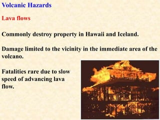
- 9. Volcanic Hazards Damage limited to the vicinity in the immediate area of the volcano. Lava flows Commonly destroy property in Hawaii and Iceland. Fatalities rare due to slow speed of advancing lava flow.
- 10. Ash fall Extensive property damage and fatalities can result from heavy ash falls. Significant ash in the upper atmosphere can circle the globe in a matter of weeks. Mt. St. Helens’ ash cloud More than 80 commercial jets have been damaged by flying through volcanic ash clouds.
- 11. Pyroclastic flows Lahars can also dam rivers and which can lead to extensive flooding. Lahars are fast moving mudflows that can inundate urban areas that are nearby the eruption.
- 12. Lahars can be the most devastating outcome of many volcanoes. Water and debris rushed down the slopes, picking up more debris along the way. A relatively small eruption of Nevada del Ruiz, Columbia, in 1985, generated a lahar when the volcano melted a 2.5 km2 area of snow and ice.
- 13. A 5 metre wall of water and debris slammed into the town of Amero, 72 km from the volcano. The lahar killed 28,700 people and destroyed over 5,000 structures in the city.
- 14. Nuée ardentes destroy life and property in their paths. 60 people, thousands of animals and fish, and hundreds of acres of lumber were destroyed by ash flows from Mt. St. Helens. A Nuée Ardent killed 20,000 people when Mt. Vesuvius exploded and shed a pyroclastic flow across the village of Pompeii in 79 AD.
- 15. People and animals died instantly from the rushing cloud of hot gas and ash.
- 16. Landslides Landslides can be generated when a volcano collapses during an eruption. During the Mt. St. Helens eruption 2.3 km3 of debris slid down the mountain at speeds up to 240 km/hr. The slide traveled over 24 km and left a 45 m deep deposit. 350,000 years ago Mt. Shasta experienced a similar eruption and landslide that was 20 times greater than that of Mt. St. Helens.
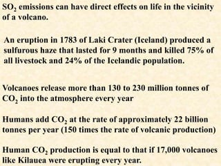
- 17. Volcanic Gases In addition to making magma more explosive, volcanic eruptions also include gases that can be deadly to all life. CO2, SO2 and CO are the most abundant of harmful gases.
- 18. Volcanoes release more than 130 to 230 million tonnes of CO2 into the atmosphere every year Humans add CO2 at the rate of approximately 22 billion tonnes per year (150 times the rate of volcanic production) Human CO2 production is equal to that if 17,000 volcanoes like Kilauea were erupting every year. SO2 emissions can have direct effects on life in the vicinity of a volcano. An eruption in 1783 of Laki Crater (Iceland) produced a sulfurous haze that lasted for 9 months and killed 75% of all livestock and 24% of the Icelandic population.
- 19. Mammoth Mountain is a relatively young volcano that is emitting large volumes of CO2. Gas concentrations in the soil in some areas near the mountain are high enough to kill trees and small animals.
- 20. If the air that we breath has more than 10% CO2 it becomes deadly because it displaces the Oxygen that we need for respiration. Lake Nios, Cameroon, is a very deep lake within a volcanic crater. The lake is so deep that hydrostatic pressure forces CO2 to remain at the lake bottom. When the pressure of the CO2 exceeds a certain limit the gas rapidly bubbles up out of the lake and flows as an invisible gas cloud down the adjacent slopes. On August 61, 1986 such a gas release flowed 19 km suffocating 1,700 people along its route.
- 21. The fountain in the background lifts CO2 up to the surface so that it no longer accumulates. Lake Nyos 10 days after the 1986 eruption
- 22. Tsunamis Caused by the displacement of seawater by eruptions of volcanic islands and submarine volcanoes. Krakatoa (1883 eruption) killed 36,000 people by the tsunami, alone (the most deadly outcome of the eruption). This is the newly forming summit of Krakatoa, growing where the 1883 eruption blew the top off of the original volcano.
- 23. Global Climate Change Due to ash and gas that may spend years in the upper atmosphere; reduces incoming solar radiation. SO2 from an eruption forms tiny droplets of sulfuric acid in the upper atmosphere. The droplets significantly increase global albedo…..a negative radiative forcing that leads to cooling. Mt. Pinatubo (1991) released 22 million metric tons of SO2 and reduced the Earth’s average temperature by 0.5 degrees Celsius in the year following the eruption.
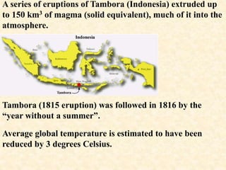
- 24. Tambora (1815 eruption) was followed in 1816 by the “year without a summer”. Average global temperature is estimated to have been reduced by 3 degrees Celsius. A series of eruptions of Tambora (Indonesia) extruded up to 150 km3 of magma (solid equivalent), much of it into the atmosphere.
- 25. Food shortages and starvation are attributed to the deaths of 80,000 people. In June of 1816 there was widespread snowfall throughout the eastern United States. The normal growing season experienced repeated frosts as cold air extended much more southerly than normal. The global population was about 1 billion people in 1816. Our current population is a little over 6 billion. The 1816 fatality rate would have resulted in a death toll of nearly 500,000 people due to starvation.
- 27. Deadly Historic Volcanic Eruptions A stratovolcano along the Caribbean trench. Mt. Pelée (West Indes) VEI = 4
- 28. Lava domes are constructed of viscous lava and are prone to collapse, unleashing a violent pyroclastic flow. An eruption in 1902 following the growth of a lava dome on the side of the mountain.
- 30. The nuée ardente that was generated when Mt. Pelée erupted swept 6 km downslope through the town of St. Vincent.
- 31. Almost the entire population of 30,000 people were killed within minutes of inhaling the hot gases and ash. There were only two survivors; one was in a dungeon!
- 32. Tambora (1815) VEI = 7 The largest eruption of historic time. Greatest impacts from pyroclastic flows and ash and gas eruptions. Approximately 150 km3 of ash was erupted with the explosions. 10,000 people were killed by bomb impacts, tephra falls and pyroclastic flows. By far the largest impact was on the Earth’s atmosphere. The eruption plume reached 44 km above the earth, loading the stratosphere with ashes and gases.
- 33. The concentration mercury in ice cores from glaciers in Wyoming record a peak in atmospheric mercury that corresponds to the Tambora eruption. The atmospheric impact caused the “year without a summer” along with 80,000 deaths due to famine and disease.
- 34. Krakatoa (1883) On the Island of Rakata, Krakatoa was one of 130 active volcanoes in Indonesia (the country with the most active volcanoes in the world). The volcano had been inactive for almost 200 years prior to a series of small eruptions that began in 1883. VEI = 6
- 35. The volcanoes of Indonesia are due to the northeastward subduction of the Indo-Australian plate beneath the Eurasian plate. Stratovolcanoes with a high probability of violent eruption.
- 36. Krakatoa began its eruptive stage on May 20, 1883 immediately following a strong earthquake (no sensors were there to measure it). The first explosions were heard 160 km away and sent steam and ash upwards to a height of 11 km. By August 11 three vents were active on the volcano. On August 26 several loud eruptions took place over the course of the day sending dust and ash to over 25 km elevation into the atmosphere.
- 37. On August 27, four very large eruptions began at 5:30 am. The last of the four was the largest and could be heard from Sri Lanka to Australia, up to 4,600 km from the volcano. A 23 km2 area of the island was gone following the fourth eruption.
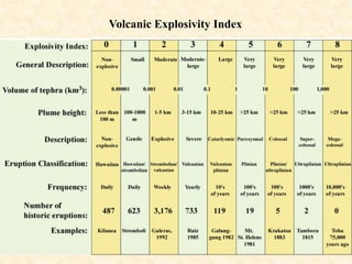
- 38. Super Volcanoes While not defined officially, lets say any eruption that ejects 1000 km3 or more of pyroclastic material (i.e., VEI 8 or more). According to M.R. Rampino super eruptions take place, on average, every 50,000 years. Three of the best known eruptions are compared below.
- 39. Toba: the world’s largest Quaternary caldera. The Australian Plate is subducting beneath the Eurasian plate at a rate of 6.7 cm/yr.
- 40. Today Toba is a caldera or depression that is occupied by Lake Toba. It is 100 km long and 30 km wide. Toba last erupted about 75,000 years ago with the largest eruption of the last 2 million years.
- 41. 840,000 years ago 500,000 years ago Three eruptive events have been recognized. 74,000 years ago Each producing a caldera. Samosir Island, rising 750 m above the lake, is a dome built from lava following the last eruption.
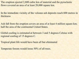
- 42. The eruption ejected 2,800 cubic km of material and the pyroclastic flows covered an area of at least 20,000 square km. In the immediate vicinity of the volcano ash deposits reach 600 metres in thickness Ash fall from the eruption covers an area of at least 4 million square km; half the area of the continental United States. Global cooling is estimated at between 3 and 5 degrees Celsius with regional cooling of 15 degrees C. Tropical plant life would have been all but eliminated Temperate forests would loose 50% of all trees.
- 43. It is estimated that the growing population of homo sapiens (i.e., us) was reduced from 100,000 individuals to as few as 3,000 individuals (97% of all humans were lost!). This reduction had been estimated for approximately the time of Toba’s eruption on the basis of genetic studies and is termed the “human population bottleneck”.
- 44. Yellowstone Caldera Known for its hot springs and geysers, Yellowstone National Park, is likely the most popular super volcano in the world. The park sits on an active caldera that rises and sinks in response to magma movement and pressure fluctuations within the Earth. Over recent years the surface has risen by as much as a metre and sunk back by 1/3 of a metre. Thousands of small earthquakes are produced as earth surface moves.
- 45. The magma chamber is only 5 to 13 km below the land surface. The caldera is 80 km long and 50 km wide.
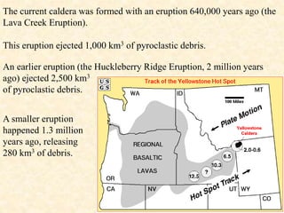
- 46. The caldera and its magma chamber are due to a hot spot in the mantle that has moved several hundred kilometres over the past 12.5 million years. The movement is due to the drift of the north American continent over the hot spot. Ancient, inactive calderas mark the path of the hot spot.
- 47. The current caldera was formed with an eruption 640,000 years ago (the Lava Creek Eruption). This eruption ejected 1,000 km3 of pyroclastic debris. An earlier eruption (the Huckleberry Ridge Eruption, 2 million years ago) ejected 2,500 km3 of pyroclastic debris. A smaller eruption happened 1.3 million years ago, releasing 280 km3 of debris.
- 48. Eruptions appear to have a 600,000 year period (that long between eruptions) so we’re overdue for another one. Previous eruptions spread ash over thousands of km2 across the US.
- 49. Heightened monitoring of the Yellowstone Caldera in recent years has led to media concern of an impending eruption. Government officials and geologists indicate that there have been no clear indicators of high risk at this time. If such an eruption were to take place, North America and the rest of the world could experience another “Dark Ages”.