Wood Group ODL Dimensional Control

Our Surveyors have a wide range of knowledge of surveying techniques and considerable experience of surveying offshore platforms and onshore installations for the oil and gas industry. Projects undertaken have ranged from the measurement of individual spools to modeling of entire platforms. Our main area of expertise is in combining laser scanning with color photography, to produce High Dynamic Range coloured three-dimensional point clouds. Using these images, designers, engineers, project managers and construction coordinators can visualize exactly what is on the installation. Project teams rely on the precision of the survey data to fabricate items that will fit when installed, without clashes. Our laser scans can be linked into a control network to provide a three-dimensional, geometrically accurate, model of an installation. Project teams are able to utilize these models to plan larger scopes of work that require construction across decks and between modules. Our Surveyors can use their experience to advise clients on the most appropriate type of survey and the deliverables required for each scope of work. Before each survey the Surveyors will liaise with engineers to ensure the chosen solution is practical, and provides the required level of accuracy. Experienced in the use of the commonly used software applications, the team is able to deliver data, drawings and models that suit clientsŌĆÖ preferences. Services include: ŌĆóLaser scanning ŌĆóTotal station surveys ŌĆóRedline markups of isometric drawings ŌĆóClash checking ŌĆóPlant Design Management System (PDMS) compatible coloured point clouds ŌĆóTruViews (freeware that enables 3D color images to be viewed and shared over the internet)


More Related Content
Similar to Wood Group ODL Dimensional Control (20)
Recently uploaded (20)


Wood Group ODL Dimensional Control
- 1. www.woodgroupodl.com Dimensional Control Survey Team ŌĆ£Zero Failures to FitŌĆØ Presented by Stewart Buchanan Global Head of Sales & Marketing
- 2. 2 www.woodgroupodl.com ’é¦ Dimensional control surveying is the technique and science whereby 3-dimensional spaces are accurately measured to determine the area between points, creating digitally mapped distances and angles. ’é¦ Dimensional control can be defined as the process of acquiring extremely accurate dimensional documentation that is spatially referenced to a known or established benchmark. Using the latest survey technology, Surveyors can measure and produce 3d Cad models from single pipe spool replacements to full FPSO/Jacket construction surveys. ’é¦ The captured data can be transformed to a clients preferred format, offering quick and easy data evaluation and problem checking. As we offer a full draughting service, we can provide full 3D models using Micro-station, 2D drawings or Point Cloud data from our Laser Scanners. What are Dimensional Control Surveys?
- 3. 3 www.woodgroupodl.com ’é¦ Your Challenges- Lack of knowledge of installation, clear visibility, little or no accurate data ’é¦ The Benefits - Preventing failures to fit, clash free installations, client owned reusable data, asset integrity, familiarisation, HSE, accurate repairs, upgrades and maintenance etc. ’é¦ Reduce Costs ŌĆō cost effective, multi use data, such as construction planning, reduce ŌĆ£hot- workŌĆØ, increase in safety, reduce on site material handling, ŌĆ£Zero failures to fitŌĆØ. Reduce the number of offshore visits ’é¦ Dimensional Control can meet these challenges and help ensure "clash-free" design and installation of projects involving piping, structural and equipment that must integrate and ŌĆ£fit first timeŌĆØ. ’é¦ Fabric & Maintenance, HSE, Familiarisation & Induction, Training, Emergency Response Why use Dimensional Control Surveys?
- 4. 4 www.woodgroupodl.com Who are we? ŌĆó Global Leaders in Dimensional Control ŌĆó Providing High-Quality, Cutting Edge Surveys to Suit Every Client's Unique Requirements ŌĆó Zero Failures to Fit
- 5. 5 www.woodgroupodl.com Introduction ’é¦ Wood Group ODL Dimensional Control Surveys provide cost effective dimensional control services to the Oil & Gas Industry: ’é¦ A Global team of experienced surveyors ŌĆō using proven technology ’é¦ Considerable experience of surveying offshore platforms and onshore installations for the oil and gas industry ’é¦ Precision survey data to fabricate items that fit when installed, without clashes
- 6. 6 www.woodgroupodl.com Why are we the best choice? ŌĆó Access to surveyors by BG project teams ŌĆó Ease of sharing data ŌĆó Communication and responsiveness ŌĆó Leading technologies on the market ŌĆó Highly qualified team of surveyors ŌĆó Output customized to customer needs
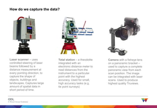
- 7. 7 www.woodgroupodl.com How do we capture the data? Laser scanner ŌĆō uses controlled steering of laser beams followed by a distance measurement at every pointing direction, to capture the shape of objects, buildings and landscapes. Captures large amount of spatial data in short period of time. Total station ŌĆō a theodolite integrated with an electronic distance meter to read distances from the instrument to a particular point with the highest accuracy. Used for small, high accuracy tasks (e.g. tie point surveys) Camera with a fisheye lens on a panoramic bracket ŌĆō used to capture a complete panoramic view from each scan position. The image can be integrated with laser scans. Used to produce highest quality Truviews.
- 8. 8 www.woodgroupodl.com What do we offer? ŌĆó Clear, high-resolution pictures of as-built installations ŌĆó Accurate measurements to plan and design tie- ins ŌĆó Visualization of potential clashes ŌĆó Re-usable surveys ŌĆó Flexibility to change scope ŌĆó Truview panoramas, available for everyone as freeware ŌĆó Integration with PDMS, AutoCAD, Microstation and Navisworks
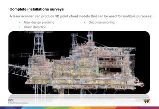
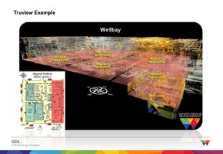
- 9. 9 www.woodgroupodl.com Complete installations surveys A laser scanner can produce 3D point cloud models that can be used for multiple purposes: ŌĆó New design planning ŌĆó Clash detection ŌĆó Tie point information ŌĆó Decommissioning
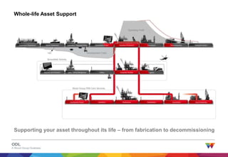
- 10. 10 www.woodgroupodl.com Whole-life Asset Support Government Negotiations Seismic Assessment Exploration / Appraisal Drilling Development Project Operation (Production) Downstream Decommissioning Relinquish License LogisticsProduction FacilitiesDrillingWells / Drilling ManagementReservoir and Production Development Project Operations Maintenance Modifications Downstream Decommissioning Operating Profit Development Costs Brownfield Activity Wood Group PSN Core Services Supporting your asset throughout its life ŌĆō from fabrication to decommissioning
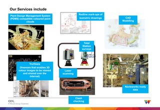
- 11. 11 www.woodgroupodl.com Our Services include Laser scanning Total Station surveys Redline mark-ups of isometric drawings Plant Design Management System (PDMS) compatible coloured point clouds TruViews (freeware that enables 3D colour images to be viewed and shared over the internet) Clash checking CAD Modelling Navisworks ready data
- 12. 12 www.woodgroupodl.com Why Wood Group ODL? The Wood Group ODL approach adds value to our clients: ŌĆó Experienced and Competent team (Fully qualified surveyors, whether single or two man projects) ŌĆó Good Track Record/Customer Satisfaction ŌĆó Growing team to meet client needs, increase availability and reduce response time ŌĆó Internal structured training and development programme ŌĆó Continual upgrade of software and techniques ŌĆó Wide range of tailored survey types ŌĆó (from total station measurement of single spools to full colour laser scans) ŌĆó Multitude of Applications ŌĆó (walk through, design, asset integrity, site training, briefings before mobilisation etc.) ŌĆó Dual benefit - Photos taken when scanning can also be used to produce high-resolution 360 degree panoramas, adding value and eliminating duplication of efforts, and the use of two providers! ŌĆó Level of Design Accuracy (1-2mm) ŌĆó No failure to fit ŌĆó Competitive pricing
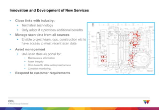
- 13. 13 www.woodgroupodl.com Innovation and Development of New Services ŌĆó Close links with industry: ŌĆó Test latest technology ŌĆó Only adopt if it provides additional benefits ŌĆó Manage scan data from all sources ŌĆó Enable project team, ops, construction etc to have access to most recent scan data ŌĆó Asset management ŌĆó Use scan data as portal for: ŌĆó Maintenance information ŌĆó Asset integrity ŌĆó Web-based to allow widespread access ŌĆó Condition monitoring ŌĆó Respond to customer requirements
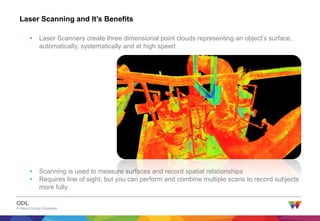
- 14. 14 www.woodgroupodl.com Laser Scanning and ItŌĆÖs Benefits ŌĆó Scanning is used to measure surfaces and record spatial relationships ŌĆó Requires line of sight, but you can perform and combine multiple scans to record subjects more fully ŌĆó Laser Scanners create three dimensional point clouds representing an objectŌĆÖs surface, automatically, systematically and at high speed
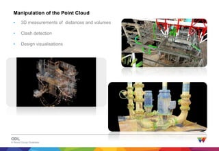
- 15. 15 www.woodgroupodl.com ŌĆó 3D measurements of distances and volumes ŌĆó Clash detection ŌĆó Design visualisations Manipulation of the Point Cloud
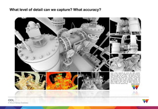
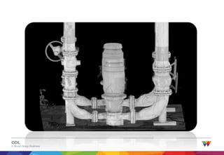
- 16. 16 www.woodgroupodl.com What level of detail can we capture? What accuracy?
- 17. 17 www.woodgroupodl.com How do we do that?
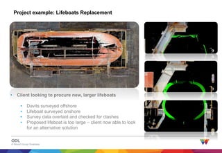
- 19. 19 www.woodgroupodl.com Project example: Lifeboats Replacement ŌĆó Client looking to procure new, larger lifeboats ŌĆó Davits surveyed offshore ŌĆó Lifeboat surveyed onshore ŌĆó Survey data overlaid and checked for clashes ŌĆó Proposed lifeboat is too large ŌĆō client now able to look for an alternative solution
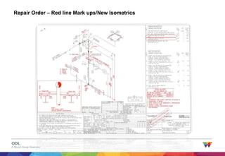
- 20. 20 www.woodgroupodl.com Repair Order ŌĆō Red line Mark ups/New Isometrics
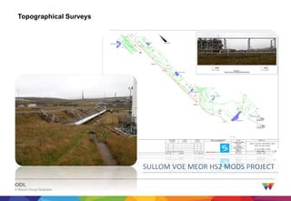
- 21. 21 www.woodgroupodl.com SULLOM VOE MEOR HS2 MODS PROJECT Topographical Surveys
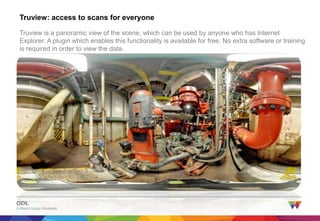
- 23. 23 www.woodgroupodl.com Truview: access to scans for everyone Truview is a panoramic view of the scene, which can be used by anyone who has Internet Explorer. A plugin which enables this functionality is available for free. No extra software or training is required in order to view the data.
- 24. 24 www.woodgroupodl.com Truview: access to scans for everyone The image is enhanced so that basic measurements can be taken directly on the screen:
- 25. 25 www.woodgroupodl.com How do we work? The scheme below shows the usual workflow of a typical project: Survey request from Client Surveyor allocated to job Surveyor discusses requirement s with Client Finalise scope of work, survey method and deliverables Prepare kit for air freight or despatch by boat Mobilise. Complete site inductions and obtain permit to work Perform the survey Return to office, process data Final scans, models and drawings delivered to Client
- 27. 27 www.woodgroupodl.com Contacts Stewart Buchanan: Wood Group ODL +44 07738 405529 stewart.buchanan@woodgroup.com