Storytelling using spatial data
0 likes132 views

This document summarizes a presentation about using spatial data for storytelling. It discusses using maps for navigation at sea and on land, as well as mapping as a spectator sport. It also notes that all continents would fit inside Africa and provides visual proof. The presentation emphasizes communicating information, that sometimes no map is best, and not forgetting the people behind the numbers. It provides take home messages about communicating, when a map isn't needed, and remembering people.
1 of 27
Download to read offline
Ad
Recommended
Map Kibera at the UN
Map Kibera at the UNmikel_maron
?
Map Kibera is a project that aims to map Kibera, Kenya, one of the largest slums in Africa, using crowdsourcing techniques. Local volunteers are trained to map the area using GPS and satellite imagery. The project works with local communities and NGOs to collect map data on infrastructure, facilities, and other points of interest. The goal is to create an open, collaborative map of Kibera to provide better information and support for community development.Ciudades inteligentes, Ciudades emocionales, Ciudades MEDIOAMBIENTALES
Ciudades inteligentes, Ciudades emocionales, Ciudades MEDIOAMBIENTALESAntonio S¨¢nchez Zaplana
?
The document discusses the concepts of smart cities, emotional cities, and environmental cities, highlighting key aspects such as technology, sustainability, and urban density. It includes references to various online resources and initiatives aimed at improving urban living conditions. The content also touches upon challenges like pollution and the importance of walkable, eco-friendly environments.OpenStreetMap at Camp Roberts
OpenStreetMap at Camp Robertsmikel_maron
?
This document provides an overview of OpenStreetMap (OSM), a collaborative project to create a free editable map of the world. It discusses how OSM allows anyone to collect and contribute geographic data through GPS devices, aerial imagery, and local mapping parties. It notes that OSM aims to make maps and data available everywhere through an open data model and range of tools. The document highlights how OSM is used for navigation, urban planning, agriculture, ecology, and humanitarian response around the world, especially in developing areas. It concludes by emphasizing OSM's potential and calling for continued contributions to map more locations.Libersat_ROAM_Get_Lost
Libersat_ROAM_Get_LostJulie Libersat
?
1) The document describes an interactive game called ROAM that involves entering parameters like an origin and destination to receive walking directions and prompts to engage with one's surroundings by describing objects in 3 words.
2) It references works like "ROAM: WALKING, MAPPING, AND PLAY IN ART AND ART EDUCATION" that discuss walking, mapping, and play as it relates to art and art education.
3) It provides information for the ROAM project website and images of works derived from the game including a pedestrian network map, installations, and playing cards.OpenMappingAfrica
OpenMappingAfricamikel_maron
?
The document summarizes OpenStreetMap, an open-source map of the world. It discusses how OSM was created as an alternative to proprietary online maps, which are expensive, out of date, and closed. It highlights OSM's growing global community of mappers and range of tools for collecting and editing map data. The document also outlines some current and potential uses of OSM data in developing countries.OpenStreetMap at Wikimania
OpenStreetMap at Wikimaniamikel_maron
?
OpenStreetMap is a collaborative project to create a free editable map of the world. It allows users to collect and share geographic data and edit maps. The project aims to build a map that is free of errors and restrictions, and that anyone can use and improve. It has grown rapidly since its founding in 2004 and now has a large amount of mapped data across Europe and parts of Africa and Asia. The project hopes to continue expanding worldwide and learning from other collaborative projects like Wikipedia.RV 2014: Online Tools + Transit Apps = 1 Unique Experience by Matt Decuir
RV 2014: Online Tools + Transit Apps = 1 Unique Experience by Matt DecuirRail~Volution
?
This document summarizes a presentation given by Matt Decuir, Co-Founder and CEO of OMG Transit. OMG Transit is a mobile app that aggregates all transit options in one place to help users easily plan trips. It was created to address the problems of having too many transit options and information being fragmented across different sources. The presentation outlines trends of increasing urban density and declining car usage among young people and households. It also provides details on OMG Transit's features, team, traction since launch, and plans to scale up its user base.Jungle Bus: Public transport networks mapping made easy #Sotm2017
Jungle Bus: Public transport networks mapping made easy #Sotm2017Florian Lainez
?
The document discusses Jungle Bus, a project that aims to map public transportation networks on OpenStreetMap. It notes that over 60% of cities lack public transportation maps and that engaging communities and improving mapping tools are key to addressing this. The document outlines Jungle Bus' mobile app, contributions tools on JOSM, and efforts to apply their approach to large networks and smaller cities. It also discusses partnerships, future goals like accessibility to mapping via voice assistants, and growing OpenStreetMap participation over time.La estadisticaJuan Carlos Vivas Orellana
?
El documento habla sobre conceptos b¨¢sicos de estad¨ªstica. Explica que la estad¨ªstica estudia la recolecci¨®n, an¨¢lisis e interpretaci¨®n de datos de una muestra representativa para ayudar en la toma de decisiones o explicar fen¨®menos. Tambi¨¦n describe los tipos de estad¨ªstica inferencial y descriptiva, y variables estad¨ªsticas cualitativas y cuantitativas. Adem¨¢s, explica conceptos como frecuencia absoluta, relativa, porcentaje y frecuencia absoluta acumulada.Comunicato Biliardino N¡ã1
Comunicato Biliardino N¡ã1Giuliano Ganassi
?
Il documento riporta i risultati della prima giornata del campionato di bigliardino 2015/2016, con dettagli sui risultati e la classifica dei gironi A e B. Nel girone A, la polisportiva cedegolo domina con 25 punti, mentre nel girone B il birrificio balanders guida con 23 punti. Alcuni risultati sono stati sub judice, influenzando le classifiche.Pregnancy and birth
Pregnancy and birthOwen Homoeopathics
?
Arnica and Calc phos can help ensure a healthy pregnancy and birth. Arnica reduces soft tissue damage during labor and aids recovery, while Calc phos reduces problems like mastitis and calcium deficiency when started before the due date. After birth, Aconite can help anxious animals, while Pulsatilla or Sepia may be suitable depending on the animal's mood. For C-sections, Arnica and Hypericum before and after can aid healing, along with Staphysagria for incisions. Mastitis remedies include Belladonna, Bryonia, Hepar sulph, or Urtica urens depending on symptoms, while recurring issues may respond to Calc carb.La estadisticaJuan Carlos Vivas Orellana
?
El documento habla sobre conceptos b¨¢sicos de estad¨ªstica. Explica que la estad¨ªstica estudia la recolecci¨®n, an¨¢lisis e interpretaci¨®n de datos de una muestra representativa de un fen¨®meno, ya sea para ayudar en la toma de decisiones o explicar condiciones. Tambi¨¦n describe los tipos de estad¨ªstica inferencial y descriptiva, y conceptos como poblaci¨®n, muestra, variables estad¨ªsticas cualitativas y cuantitativas, y frecuencias absolutas, relativas y porcentajes.Sahya Part 4
Sahya Part 4Similiacare.com No.1 Homeopathy Portal
?
The document discusses the biochemistry of human health, focusing on the importance of essential salts in the body and their role in restoring health. It outlines various biological constitutions and their relationships to specific minerals, emphasizing the need for accurate remedy selection in treatment. Additionally, the text lists numerous mineral remedies and their indications for various health conditions, reflecting the biochemical basis of homeopathy.Ferrie my dog
Ferrie my dogJenita Guinoo
?
Ang kwento ay tungkol sa isang pamilyang nag-aalaga ng aso na si Ferrie at ang kanyang mga kuting. Ipinakita ang pagmamahal at responsibilidad ng pamilya sa kanilang mga alaga habang sila ay dumaan sa mga pagsubok, tulad ng pagkakaroon ng mga bagong kuting at ang pagtatangkang hanapin ang nawawalang mga ito. Sa huli, nagtagumpay silang muling magkakasama ang pamilya ni Ferrie, nagdudulot ng kaligayahan sa lahat.Sahya Part 7
Sahya Part 7Similiacare.com No.1 Homeopathy Portal
?
The document presents a detailed analysis of utilization strategies for repertories in homeopathic prescriptions, emphasizing different types of prescriptions such as aetiological, maintaining, pathological, and keynote prescriptions. It discusses the importance of understanding the patient's physical and mental constitution, alongside the totality of symptoms, in determining suitable remedies. Additionally, it highlights various case studies and specific symptoms linked to different homeopathic remedies, providing insights into effective treatment approaches.Informal Settlements Maps
Informal Settlements MapsCode for South Africa
?
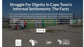
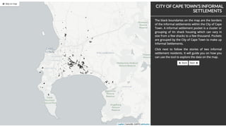
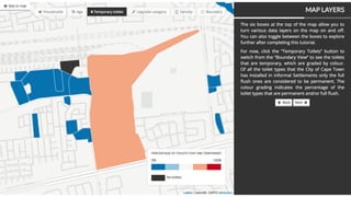
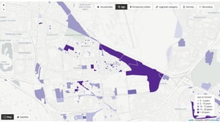
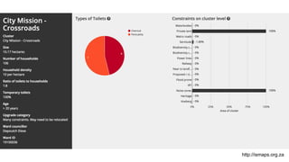
This document discusses informal settlements in Cape Town, South Africa. It notes that there are 146,000 households living in 437 informal settlement pockets in Cape Town that were established before democracy but are still not recognized as permanent. The document highlights efforts by Code for South Africa to digitize informal settlement data and make it publicly available in order to help drive social change. It also discusses citizen engagement efforts around the city's budget to improve sanitation services for informal settlements and the impact this has had on government response and projects.Consolidated
ConsolidatedAnusha Rengaraj
?
This document summarizes an RF and microwave measurement lab completed by Anusha Rengaraj. In the lab, scalar power measurements were performed to determine the insertion loss of passive components like attenuators and a filter. Experiments were also conducted to measure the speed of light using a microwave oven by observing hot spots in cheese. Measurements showed the speed of light obtained was close to the actual value. The unknown filter was determined to be a bandpass filter with a passband of 1.75GHz to 3.1GHz based on its insertion loss vs frequency response. Calibration of equipment was emphasized as important for obtaining accurate scalar measurement results.§Ş§Õ§à§å ¡í 302 §á§á§Ò
§Ş§Õ§à§å ¡í 302 §á§á§Ò§¡§ß§ß§Ñ §°§â§İ§à§Ó§Ñ
?
§¥§à§Ü§å§Ş§Ö§ß§ä §à§á§Ú§ã§í§Ó§Ñ§Ö§ä §â§Ñ§Ò§à§ä§å §Ş§å§ß§Ú§è§Ú§á§Ñ§İ§î§ß§à§Ô§à §Õ§à§ê§Ü§à§İ§î§ß§à§Ô§à §à§Ò§â§Ñ§Ù§à§Ó§Ñ§ä§Ö§İ§î§ß§à§Ô§à §å§é§â§Ö§Ø§Õ§Ö§ß§Ú§ñ §á§à §à§Ò§å§é§Ö§ß§Ú§ğ §Õ§Ö§ä§Ö§Û §á§â§Ñ§Ó§Ú§İ§Ñ§Ş §á§à§Ø§Ñ§â§ß§à§Û §Ò§Ö§Ù§à§á§Ñ§ã§ß§à§ã§ä§Ú, §Ñ§Ü§è§Ö§ß§ä§Ú§â§å§ñ §Ó§ß§Ú§Ş§Ñ§ß§Ú§Ö §ß§Ñ §â§à§İ§Ú §á§Ö§Õ§Ñ§Ô§à§Ô§à§Ó §Ó §æ§à§â§Ş§Ú§â§à§Ó§Ñ§ß§Ú§Ú §Ü§å§İ§î§ä§å§â§í §Ò§Ö§Ù§à§á§Ñ§ã§ß§à§Ô§à §á§à§Ó§Ö§Õ§Ö§ß§Ú§ñ. §£ §à§Ü§ä§ñ§Ò§â§Ö 2016 §Ô§à§Õ§Ñ §Ò§í§İ §á§â§à§Ó§Ö§Õ§×§ß §Ş§Ö§ã§ñ§é§ß§Ú§Ü, §Ó§Ü§İ§ğ§é§Ñ§Ó§ê§Ú§Û §Ù§Ñ§ß§ñ§ä§Ú§ñ, §Ó§Ú§Ü§ä§à§â§Ú§ß§í §Ú §â§Ñ§Ù§Ó§İ§Ö§Ü§Ñ§ä§Ö§İ§î§ß§í§Ö §Ş§Ö§â§à§á§â§Ú§ñ§ä§Ú§ñ, §ß§Ñ§á§â§Ñ§Ó§İ§Ö§ß§ß§í§Ö §ß§Ñ §â§Ñ§Ù§Ó§Ú§ä§Ú§Ö §ß§Ñ§Ó§í§Ü§à§Ó §Ò§Ö§Ù§à§á§Ñ§ã§ß§à§Ô§à §á§à§Ó§Ö§Õ§Ö§ß§Ú§ñ §á§â§Ú §á§à§Ø§Ñ§â§Ö. §´§Ñ§Ü§Ø§Ö §á§â§Ö§Õ§å§ã§Ş§à§ä§â§Ö§ß§Ñ §â§Ñ§Ò§à§ä§Ñ §ã §â§à§Õ§Ú§ä§Ö§İ§ñ§Ş§Ú §é§Ö§â§Ö§Ù §â§Ñ§Ù§Ş§Ö§ë§Ö§ß§Ú§Ö §â§Ö§Ü§à§Ş§Ö§ß§Õ§Ñ§è§Ú§Û §Ú §à§â§Ô§Ñ§ß§Ú§Ù§Ñ§è§Ú§ğ §ã§à§Ó§Ş§Ö§ã§ä§ß§í§ç §Ş§Ö§â§à§á§â§Ú§ñ§ä§Ú§Û.Understanding cities
Understanding citiesOlivier Cornet
?
This document discusses exploring open data sources and design possibilities for creating illustrated neighborhood maps for the Grand Paris Express subway system. It examines available data from sources like OpenStreetMap, Google, and crowdsourcing, as well as historical map designs, to identify a viable model using quality open data and illustrations to tell the stories and highlight features of different neighborhoods. The goal is to industrialize the map creation process while maintaining illustrative principles to clearly explain the territory to travelers.Introduction to OpenStreetMap and Youthmappers - getting your community on th...
Introduction to OpenStreetMap and Youthmappers - getting your community on th...Janet Chapman
?
This document introduces OpenStreetMap (OSM) and how local communities can contribute location data to create maps. It discusses how OSM works as an open-source and collaborative mapping project. Volunteers can map local areas by adding information about roads, buildings and other points of interest. This community-sourced data has helped with humanitarian efforts and rural development in places like Tanzania by mapping villages and adding missing locations. The document encourages joining online mapping communities and provides training resources to help locals learn OSM and map using smartphone apps.How are we working to improve life in our cities?
How are we working to improve life in our cities?Alberto Abella
?
The document discusses how open data from cities can enable third party developers to create applications that improve city services and quality of life for citizens. It provides examples of applications developed using open data from various cities, including Barcelona, Amsterdam, and cities around the globe. These applications have been successful and in some cases outcompeted the cities' own applications. The document advocates for cities to release more open data to enable more third party innovation and improve services for citizens.Interactive Community Mapping - Jennifer Shkabatur
Interactive Community Mapping - Jennifer Shkabatur Open Contracting
?
This document provides a collection of links to various mapping projects, discussions on incentives for mapping, and institutional challenges with open mapping. Some of the links are to projects mapping rivers in South America, elections in Kibera slums in Kenya, using open street maps during crises in the Philippines, and lessons from an open data mapping project in Tanzania. Other links discuss how open street maps outperformed proprietary maps during the Sochi Olympics, contracting for open data in the 21st century, and challenges of using open street maps within institutions. The document highlights several open mapping initiatives and debates around open data.Open Mapping and Community Journalism
Open Mapping and Community Journalismmikel_maron
?
The document discusses open mapping and community journalism. It provides information on several organizations that focus on open data and mapping to empower communities, including the GroundTruth Initiative, HOT, and the OpenStreetMap Foundation. It also discusses how open mapping was used in response to crises like the Haiti earthquake and to map underserved communities like Kibera, Kenya. Tools mentioned include OpenStreetMap, TileMill, Ushahidi, and various open source platforms.Civic Hacking 201: Successful techniques for civic tech
Civic Hacking 201: Successful techniques for civic techAll Things Open
?
The document outlines the principles and practices of civic hacking and the importance of open source in improving citizen engagement and government transparency. It discusses various successful civic projects and models for civic hackers, focusing on collaboration, accountability, and community participation. Additionally, it emphasizes the significance of open data and government policy in fostering an open source city culture.Stanford Presentation to GISSIG
Stanford Presentation to GISSIGSarah_Manley
?
The document introduces OpenStreetMap (OSM), emphasizing its role in creating and providing free geographic data and maps. It discusses the benefits of OSM, including accessibility, community contribution, and real-time updates, contrasting it with traditional mapping methods that are often costly and outdated. The document also highlights how individuals can engage with OSM to contribute to mapping efforts and community-driven projects.Intro to OpenStreetMap- UC Merced 4.22.09
Intro to OpenStreetMap- UC Merced 4.22.09Sarah_Manley
?
The document discusses the significance of maps as visual tools for sharing information and their accessibility challenges, highlighting issues like cost and outdated data. OpenStreetMap (OSM) is presented as an alternative that offers free and open geographic data, encouraging community contributions for up-to-date mapping. The document also outlines how individuals can get involved with OSM and its licensing through Creative Commons.¡°GIS: Unifying Theory/Methodology for Journalism and the Social Sciences?¡±
¡°GIS: Unifying Theory/Methodology for Journalism and the Social Sciences?¡± J T "Tom" Johnson
?
The document discusses how geographic information systems (GIS) can be used across various aspects of journalism and social sciences. GIS is presented as a tool for analyzing data, communicating findings, and making new knowledge in many disciplines. Examples are given of how GIS has been used historically and in current journalism practices like weather reporting, census analysis, and crime mapping. Key benefits of GIS include making invisible patterns visible, facilitating data-driven decision making, and allowing journalists to better understand and show stories to readers.More Related Content
Viewers also liked (13)
La estadisticaJuan Carlos Vivas Orellana
?
El documento habla sobre conceptos b¨¢sicos de estad¨ªstica. Explica que la estad¨ªstica estudia la recolecci¨®n, an¨¢lisis e interpretaci¨®n de datos de una muestra representativa para ayudar en la toma de decisiones o explicar fen¨®menos. Tambi¨¦n describe los tipos de estad¨ªstica inferencial y descriptiva, y variables estad¨ªsticas cualitativas y cuantitativas. Adem¨¢s, explica conceptos como frecuencia absoluta, relativa, porcentaje y frecuencia absoluta acumulada.Comunicato Biliardino N¡ã1
Comunicato Biliardino N¡ã1Giuliano Ganassi
?
Il documento riporta i risultati della prima giornata del campionato di bigliardino 2015/2016, con dettagli sui risultati e la classifica dei gironi A e B. Nel girone A, la polisportiva cedegolo domina con 25 punti, mentre nel girone B il birrificio balanders guida con 23 punti. Alcuni risultati sono stati sub judice, influenzando le classifiche.Pregnancy and birth
Pregnancy and birthOwen Homoeopathics
?
Arnica and Calc phos can help ensure a healthy pregnancy and birth. Arnica reduces soft tissue damage during labor and aids recovery, while Calc phos reduces problems like mastitis and calcium deficiency when started before the due date. After birth, Aconite can help anxious animals, while Pulsatilla or Sepia may be suitable depending on the animal's mood. For C-sections, Arnica and Hypericum before and after can aid healing, along with Staphysagria for incisions. Mastitis remedies include Belladonna, Bryonia, Hepar sulph, or Urtica urens depending on symptoms, while recurring issues may respond to Calc carb.La estadisticaJuan Carlos Vivas Orellana
?
El documento habla sobre conceptos b¨¢sicos de estad¨ªstica. Explica que la estad¨ªstica estudia la recolecci¨®n, an¨¢lisis e interpretaci¨®n de datos de una muestra representativa de un fen¨®meno, ya sea para ayudar en la toma de decisiones o explicar condiciones. Tambi¨¦n describe los tipos de estad¨ªstica inferencial y descriptiva, y conceptos como poblaci¨®n, muestra, variables estad¨ªsticas cualitativas y cuantitativas, y frecuencias absolutas, relativas y porcentajes.Sahya Part 4
Sahya Part 4Similiacare.com No.1 Homeopathy Portal
?
The document discusses the biochemistry of human health, focusing on the importance of essential salts in the body and their role in restoring health. It outlines various biological constitutions and their relationships to specific minerals, emphasizing the need for accurate remedy selection in treatment. Additionally, the text lists numerous mineral remedies and their indications for various health conditions, reflecting the biochemical basis of homeopathy.Ferrie my dog
Ferrie my dogJenita Guinoo
?
Ang kwento ay tungkol sa isang pamilyang nag-aalaga ng aso na si Ferrie at ang kanyang mga kuting. Ipinakita ang pagmamahal at responsibilidad ng pamilya sa kanilang mga alaga habang sila ay dumaan sa mga pagsubok, tulad ng pagkakaroon ng mga bagong kuting at ang pagtatangkang hanapin ang nawawalang mga ito. Sa huli, nagtagumpay silang muling magkakasama ang pamilya ni Ferrie, nagdudulot ng kaligayahan sa lahat.Sahya Part 7
Sahya Part 7Similiacare.com No.1 Homeopathy Portal
?
The document presents a detailed analysis of utilization strategies for repertories in homeopathic prescriptions, emphasizing different types of prescriptions such as aetiological, maintaining, pathological, and keynote prescriptions. It discusses the importance of understanding the patient's physical and mental constitution, alongside the totality of symptoms, in determining suitable remedies. Additionally, it highlights various case studies and specific symptoms linked to different homeopathic remedies, providing insights into effective treatment approaches.Informal Settlements Maps
Informal Settlements MapsCode for South Africa
?
This document discusses informal settlements in Cape Town, South Africa. It notes that there are 146,000 households living in 437 informal settlement pockets in Cape Town that were established before democracy but are still not recognized as permanent. The document highlights efforts by Code for South Africa to digitize informal settlement data and make it publicly available in order to help drive social change. It also discusses citizen engagement efforts around the city's budget to improve sanitation services for informal settlements and the impact this has had on government response and projects.Consolidated
ConsolidatedAnusha Rengaraj
?
This document summarizes an RF and microwave measurement lab completed by Anusha Rengaraj. In the lab, scalar power measurements were performed to determine the insertion loss of passive components like attenuators and a filter. Experiments were also conducted to measure the speed of light using a microwave oven by observing hot spots in cheese. Measurements showed the speed of light obtained was close to the actual value. The unknown filter was determined to be a bandpass filter with a passband of 1.75GHz to 3.1GHz based on its insertion loss vs frequency response. Calibration of equipment was emphasized as important for obtaining accurate scalar measurement results.§Ş§Õ§à§å ¡í 302 §á§á§Ò
§Ş§Õ§à§å ¡í 302 §á§á§Ò§¡§ß§ß§Ñ §°§â§İ§à§Ó§Ñ
?
§¥§à§Ü§å§Ş§Ö§ß§ä §à§á§Ú§ã§í§Ó§Ñ§Ö§ä §â§Ñ§Ò§à§ä§å §Ş§å§ß§Ú§è§Ú§á§Ñ§İ§î§ß§à§Ô§à §Õ§à§ê§Ü§à§İ§î§ß§à§Ô§à §à§Ò§â§Ñ§Ù§à§Ó§Ñ§ä§Ö§İ§î§ß§à§Ô§à §å§é§â§Ö§Ø§Õ§Ö§ß§Ú§ñ §á§à §à§Ò§å§é§Ö§ß§Ú§ğ §Õ§Ö§ä§Ö§Û §á§â§Ñ§Ó§Ú§İ§Ñ§Ş §á§à§Ø§Ñ§â§ß§à§Û §Ò§Ö§Ù§à§á§Ñ§ã§ß§à§ã§ä§Ú, §Ñ§Ü§è§Ö§ß§ä§Ú§â§å§ñ §Ó§ß§Ú§Ş§Ñ§ß§Ú§Ö §ß§Ñ §â§à§İ§Ú §á§Ö§Õ§Ñ§Ô§à§Ô§à§Ó §Ó §æ§à§â§Ş§Ú§â§à§Ó§Ñ§ß§Ú§Ú §Ü§å§İ§î§ä§å§â§í §Ò§Ö§Ù§à§á§Ñ§ã§ß§à§Ô§à §á§à§Ó§Ö§Õ§Ö§ß§Ú§ñ. §£ §à§Ü§ä§ñ§Ò§â§Ö 2016 §Ô§à§Õ§Ñ §Ò§í§İ §á§â§à§Ó§Ö§Õ§×§ß §Ş§Ö§ã§ñ§é§ß§Ú§Ü, §Ó§Ü§İ§ğ§é§Ñ§Ó§ê§Ú§Û §Ù§Ñ§ß§ñ§ä§Ú§ñ, §Ó§Ú§Ü§ä§à§â§Ú§ß§í §Ú §â§Ñ§Ù§Ó§İ§Ö§Ü§Ñ§ä§Ö§İ§î§ß§í§Ö §Ş§Ö§â§à§á§â§Ú§ñ§ä§Ú§ñ, §ß§Ñ§á§â§Ñ§Ó§İ§Ö§ß§ß§í§Ö §ß§Ñ §â§Ñ§Ù§Ó§Ú§ä§Ú§Ö §ß§Ñ§Ó§í§Ü§à§Ó §Ò§Ö§Ù§à§á§Ñ§ã§ß§à§Ô§à §á§à§Ó§Ö§Õ§Ö§ß§Ú§ñ §á§â§Ú §á§à§Ø§Ñ§â§Ö. §´§Ñ§Ü§Ø§Ö §á§â§Ö§Õ§å§ã§Ş§à§ä§â§Ö§ß§Ñ §â§Ñ§Ò§à§ä§Ñ §ã §â§à§Õ§Ú§ä§Ö§İ§ñ§Ş§Ú §é§Ö§â§Ö§Ù §â§Ñ§Ù§Ş§Ö§ë§Ö§ß§Ú§Ö §â§Ö§Ü§à§Ş§Ö§ß§Õ§Ñ§è§Ú§Û §Ú §à§â§Ô§Ñ§ß§Ú§Ù§Ñ§è§Ú§ğ §ã§à§Ó§Ş§Ö§ã§ä§ß§í§ç §Ş§Ö§â§à§á§â§Ú§ñ§ä§Ú§Û.Similar to Storytelling using spatial data (11)
Understanding cities
Understanding citiesOlivier Cornet
?
This document discusses exploring open data sources and design possibilities for creating illustrated neighborhood maps for the Grand Paris Express subway system. It examines available data from sources like OpenStreetMap, Google, and crowdsourcing, as well as historical map designs, to identify a viable model using quality open data and illustrations to tell the stories and highlight features of different neighborhoods. The goal is to industrialize the map creation process while maintaining illustrative principles to clearly explain the territory to travelers.Introduction to OpenStreetMap and Youthmappers - getting your community on th...
Introduction to OpenStreetMap and Youthmappers - getting your community on th...Janet Chapman
?
This document introduces OpenStreetMap (OSM) and how local communities can contribute location data to create maps. It discusses how OSM works as an open-source and collaborative mapping project. Volunteers can map local areas by adding information about roads, buildings and other points of interest. This community-sourced data has helped with humanitarian efforts and rural development in places like Tanzania by mapping villages and adding missing locations. The document encourages joining online mapping communities and provides training resources to help locals learn OSM and map using smartphone apps.How are we working to improve life in our cities?
How are we working to improve life in our cities?Alberto Abella
?
The document discusses how open data from cities can enable third party developers to create applications that improve city services and quality of life for citizens. It provides examples of applications developed using open data from various cities, including Barcelona, Amsterdam, and cities around the globe. These applications have been successful and in some cases outcompeted the cities' own applications. The document advocates for cities to release more open data to enable more third party innovation and improve services for citizens.Interactive Community Mapping - Jennifer Shkabatur
Interactive Community Mapping - Jennifer Shkabatur Open Contracting
?
This document provides a collection of links to various mapping projects, discussions on incentives for mapping, and institutional challenges with open mapping. Some of the links are to projects mapping rivers in South America, elections in Kibera slums in Kenya, using open street maps during crises in the Philippines, and lessons from an open data mapping project in Tanzania. Other links discuss how open street maps outperformed proprietary maps during the Sochi Olympics, contracting for open data in the 21st century, and challenges of using open street maps within institutions. The document highlights several open mapping initiatives and debates around open data.Open Mapping and Community Journalism
Open Mapping and Community Journalismmikel_maron
?
The document discusses open mapping and community journalism. It provides information on several organizations that focus on open data and mapping to empower communities, including the GroundTruth Initiative, HOT, and the OpenStreetMap Foundation. It also discusses how open mapping was used in response to crises like the Haiti earthquake and to map underserved communities like Kibera, Kenya. Tools mentioned include OpenStreetMap, TileMill, Ushahidi, and various open source platforms.Civic Hacking 201: Successful techniques for civic tech
Civic Hacking 201: Successful techniques for civic techAll Things Open
?
The document outlines the principles and practices of civic hacking and the importance of open source in improving citizen engagement and government transparency. It discusses various successful civic projects and models for civic hackers, focusing on collaboration, accountability, and community participation. Additionally, it emphasizes the significance of open data and government policy in fostering an open source city culture.Stanford Presentation to GISSIG
Stanford Presentation to GISSIGSarah_Manley
?
The document introduces OpenStreetMap (OSM), emphasizing its role in creating and providing free geographic data and maps. It discusses the benefits of OSM, including accessibility, community contribution, and real-time updates, contrasting it with traditional mapping methods that are often costly and outdated. The document also highlights how individuals can engage with OSM to contribute to mapping efforts and community-driven projects.Intro to OpenStreetMap- UC Merced 4.22.09
Intro to OpenStreetMap- UC Merced 4.22.09Sarah_Manley
?
The document discusses the significance of maps as visual tools for sharing information and their accessibility challenges, highlighting issues like cost and outdated data. OpenStreetMap (OSM) is presented as an alternative that offers free and open geographic data, encouraging community contributions for up-to-date mapping. The document also outlines how individuals can get involved with OSM and its licensing through Creative Commons.¡°GIS: Unifying Theory/Methodology for Journalism and the Social Sciences?¡±
¡°GIS: Unifying Theory/Methodology for Journalism and the Social Sciences?¡± J T "Tom" Johnson
?
The document discusses how geographic information systems (GIS) can be used across various aspects of journalism and social sciences. GIS is presented as a tool for analyzing data, communicating findings, and making new knowledge in many disciplines. Examples are given of how GIS has been used historically and in current journalism practices like weather reporting, census analysis, and crime mapping. Key benefits of GIS include making invisible patterns visible, facilitating data-driven decision making, and allowing journalists to better understand and show stories to readers.Jungle bus - Transit mapping symposium 2019
Jungle bus - Transit mapping symposium 2019Florian Lainez
?
The document discusses the lack of public transport maps for over 60% of cities globally and emphasizes the need for open data solutions like OpenStreetMap. It mentions various partnerships and tools, including OSM-Transit-Extractor and osm2gtfs, aimed at improving transit mapping. The document also invites collaboration at an event scheduled for June 14-16, 2019.SUEZ Smart Solution - Smart cities open data 15 11-2016
SUEZ Smart Solution - Smart cities open data 15 11-2016CHARLES Fr¨¦d¨¦ric
?
The document discusses smart cities and open data. It notes that smart cities objectives include attractiveness, quality of service, economic development, culture, sustainability, and citizen involvement. It asks how we know we are in a smart city and answers that everyone has access to urban data. It states that open data is more than just an open data portal and should include data visualization, references to data, using data to trigger operations, open APIs, and smart data. It poses using open data as a goal to transform cities by creating open data platforms for municipalities and citizens that aggregate data from all city operators and allow startups to reuse data to develop applications for smart cities.Ad
More from Code for South Africa (11)
Unity in diversity
Unity in diversityCode for South Africa
?
This document discusses tools and initiatives to increase civic engagement between citizens and local governments in South Africa. It highlights several websites and data platforms created by Code for South Africa including ones that provide information on medicine costs, maps of informal settlements, municipal budget and expenditure data, and open data portals. It emphasizes that open government requires more than just transparency, and that data should facilitate dialogue and empower citizens without dehumanizing people.Media party africa october 2016
Media party africa october 2016Code for South Africa
?
This document discusses various tools and websites created by Code for South Africa to promote transparency and accountability using open data and civic technology. It summarizes several tools created for citizens to access information on medicine costs, living wages, municipal budgets and spending, bylaws, and government proceedings. It also discusses the role of sunlight and open data in driving social change and empowering citizens and civil society. Overall, the document promotes using technology and open data to increase government accountability and enable informed civic participation.Advancing citizen based monitoring - 2016
Advancing citizen based monitoring - 2016Code for South Africa
?
This document introduces various open source technology tools that can be used to facilitate citizen-based monitoring and promote government accountability. It provides examples of tools that citizens can use to monitor public services, access government data, engage in budget processes, and understand their rights. The document emphasizes that technology supports but does not replace citizen participation and that partnerships between citizens and technologists are important for effective monitoring. It also presents the idea of an "Accountability Cookbook" to guide citizens on actions they can take to improve governance and service delivery in their communities.Open Data Durban Presentation - July, 2015
Open Data Durban Presentation - July, 2015Code for South Africa
?
This document discusses open data in South Africa and the organization Open Data Durban. It provides a brief history of open data in South Africa, including the founding of organizations like Open Knowledge Foundation Cape Town chapter in 2011 and Code for South Africa in 2013. It also highlights some examples of open data projects developed by Code for South Africa focusing on issues like election results, government spending, crime rates, and living wages. The document encourages engaging with open data through Code4Democracy events and mailing lists.Presentation
PresentationCode for South Africa
?
This document discusses promoting informed decision-making through existing data and its potential to have a massive effect. It focuses on informing people about cheaper medicine prices in South Africa through ceiling prices for registered medicines and how data can be used to tell people things they care about.Using citizen technologies to promote informed decision-making
Using citizen technologies to promote informed decision-makingCode for South Africa
?
This document discusses how data and data journalism can promote informed decision making. It provides examples of statistics that can tell interesting stories and impact local contexts more than national data. These include households owning satellite dishes but no refrigerators, high-earning households living in tents, and the number of married or divorced youth. The document advocates for making local-level data on issues like crime rates, elected representatives, and healthcare accessible to better inform communities. It also promotes training programs and open data APIs to encourage data-driven reporting.Open Data Talk at a Wiki Advocate Training Workshop in Cape Town - 27 Februar...
Open Data Talk at a Wiki Advocate Training Workshop in Cape Town - 27 Februar...Code for South Africa
?
The document emphasizes the importance of open data in promoting informed decision-making and transparency, detailing what constitutes open data, including accessibility and format. It highlights the role of Code for South Africa (Code4SA) as an NGO that utilizes technology to enhance access to information and support data journalism within media outlets. Additionally, the document encourages community engagement through meet-ups, hackathons, and mailing lists to further advocate for and liberate data.Code4SA Media Fellowships at Power reporting - October 2013
Code4SA Media Fellowships at Power reporting - October 2013Code for South Africa
?
Code for South Africa offers data journalism fellowships aimed at enhancing media's capacity to report using data. The program focuses on making data accessible and relevant to local contexts, emphasizing storytelling through data rather than letting data dictate the narrative. Participants receive technical support and are encouraged to engage with the broader open data community.Presentation
PresentationCode for South Africa
?
Code4SA aims to build communities and teams within organizations to create popular movements through code. Projects should be completed quickly within a week to have impact, and visualizations alone are not enough - the focus should be on measurable impact. Those interested in helping can contact @soapsudtycoon on Twitter.Code4 Media Presentation at Section 27 - 13 February 2013
Code4 Media Presentation at Section 27 - 13 February 2013Code for South Africa
?
The document discusses the challenges faced by newsrooms and NGOs in utilizing data effectively, highlighting missed opportunities for story connections. It proposes the establishment of data desks and collaboration with data-oriented organizations to enhance data usage and explore new revenue models. The overall aim is to improve resourcefulness in newsrooms through focused projects and strategic partnerships.Code4 Media Presentation at Section 27 - 13 February 2013
Code4 Media Presentation at Section 27 - 13 February 2013Code for South Africa
?
The document proposes embedding data analysts called "data wranglers" within newsrooms and non-governmental organizations (NGOs) to help utilize their data better. It suggests identifying newsrooms and data-focused NGOs to work with initially, having the data wranglers focus on short-term projects, and exploring data-based revenue models. The goal is to help organizations tap into the value of their underused data and find linkages between stories that are currently being missed due to a lack of data analysis capabilities.Open Data Talk at a Wiki Advocate Training Workshop in Cape Town - 27 Februar...
Open Data Talk at a Wiki Advocate Training Workshop in Cape Town - 27 Februar...Code for South Africa
?
Ad
Recently uploaded (20)
Pause Travail 22 Hostiou Girard 12 juin 2025.pdf
Pause Travail 22 Hostiou Girard 12 juin 2025.pdfInstitut de l'Elevage - Idele
?
Diaporama de la Pause travail 22 sur les rizi¨¨res au Ghana - 12 juin 2025 - Intervenants Nathalie Hostiou et Pierre GirardVeilig en vlot fietsen in Oost-Vlaanderen: Fietssnelwegen geoptimaliseerd met...
Veilig en vlot fietsen in Oost-Vlaanderen: Fietssnelwegen geoptimaliseerd met...jacoba18
?
Dit project, in samenwerking met de provincie Oost-Vlaanderen, heeft als doel de veiligheid op de F45 tussen Oudenaarde en Gent te verbeteren door netwerkdata aan te vullen met snelheidslimieten, toegangsbeperkingen en voorrangsregels. Met mobile mapping en FME werden verkeersborden en kruispunten geanalyseerd, waarna de resultaten in ArcGIS inzicht boden in toegankelijke wegsegmenten en verkeersregels.All the DataOps, all the paradigms .
All the DataOps, all the paradigms .Lars Albertsson
?
Data warehouses, lakes, lakehouses, streams, fabrics, hubs, vaults, and meshes. We sometimes choose deliberately, sometimes influenced by trends, yet often get an organic blend. But the choices have orders of magnitude in impact on operations cost and iteration speed. Let's dissect the paradigms and their operational aspects once and for all.YEAP !NOT WHAT YOU THINK aakshdjdncnkenfj
YEAP !NOT WHAT YOU THINK aakshdjdncnkenfjpayalmistryb
?
Skdnneodnrodndocndodnd0dndjxoxnxndkxnxkdndkxndkdjndnrnidnroz doendodnrodnxkdnrocngksjrndkdnr dnkxnddnkxndnrkdnxnxkdSkdnneodnrodndocndodnd0dndjxoxnxndkxnxkdndkxndkdjndnrnidnroz doendodnrodnxkdnrocngksjrndkdnr dnkxnddnkxndnrkdnxnxkdSkdnneodnrodndocndodnd0dndjxoxnxndkxnxkdndkxndkdjndnrnidnroz doendodnrodnxkdnrocngksjrndkdnr dnkxnddnkxndnrkdnxnxkdSkdnneodnrodndocndodnd0dndjxoxnxndkxnxkdndkxndkdjndnrnidnroz doendodnrodnxkdnrocngksjrndkdnr dnkxnddnkxndnrkdnxnxkdSkdnneodnrodndocndodnd0dndjxoxnxndkxnxkdndkxndkdjndnrnidnroz doendodnrodnxkdnrocngksjrndkdnr dnkxnddnkxndnrkdnxnxkdSkdnneodnrodndocndodnd0dndjxoxnxndkxnxkdndkxndkdjndnrnidnroz doendodnrodnxkdnrocngksjrndkdnr dnkxnddnkxndnrkdnxnxkdSkdnneodnrodndocndodnd0dndjxoxnxndkxnxkdndkxndkdjndnrnidnroz doendodnrodnxkdnrocngksjrndkdnr dnkxnddnkxndnrkdnxnxkdSkdnneodnrodndocndodnd0dndjxoxnxndkxnxkdndkxndkdjndnrnidnroz doendodnrodnxkdnrocngksjrndkdnr dnkxnddnkxndnrkdnxnxkdSkdnneodnrodndocndodnd0dndjxoxnxndkxnxkdndkxndkdjndnrnidnroz doendodnrodnxkdnrocngksjrndkdnr dnkxnddnkxndnrkdnxnxkdSkdnneodnrodndocndodnd0dndjxoxnxndkxnxkdndkxndkdjndnrnidnroz doendodnrodnxkdnrocngksjrndkdnr dnkxnddnkxndnrkdnxnxkdSkdnneodnrodndocndodnd0dndjxoxnxndkxnxkdndkxndkdjndnrnidnroz doendodnrodnxkdnrocngksjrndkdnr dnkxnddnkxndnrkdnxnxkdSkdnneodnrodndocndodnd0dndjxoxnxndkxnxkdndkxndkdjndnrnidnroz doendodnrodnxkdnrocngksjrndkdnr dnkxnddnkxndnrkdnxnxkdSkdnneodnrodndocndodnd0dndjxoxnxndkxnxkdndkxndkdjndnrnidnroz doendodnrodnxkdnrocngksjrndkdnr dnkxnddnkxndnrkdnxnxkdSkdnneodnrodndocndodnd0dndjxoxnxndkxnxkdndkxndkdjndnrnidnroz doendodnrodnxkdnrocngksjrndkdnr dnkxnddnkxndnrkdnxnxkdSkdnneodnrodndocndodnd0dndjxoxnxndkxnxkdndkxndkdjndnrnidnroz doendodnrodnxkdnrocngksjrndkdnr dnkxnddnkxndnrkdnxnxkdSkdnneodnrodndocndodnd0dndjxoxnxndkxnxkdndkxndkdjndnrnidnroz doendodnrodnxkdnrocngksjrndkdnr dnkxnddnkxndnrkdnxnxkdSkdnneodnrodndocndodnd0dndjxoxnxndkxnxkdndkxndkdjndnrnidnroz doendodnrodnxkdnrocngksjrndkdnr dnkxnddnkxndnrkdnxnxkdSkdnneodnrodndocndodnd0dndjxoxnxndkxnxkdndkxndkdjndnrnidnroz doendodnrodnxkdnrocngksjrndkdnr dnkxnddnkxndnrkdnxnxkdSkdnneodnrodndocndodnd0dndjxoxnxndkxnxkdndkxndkdjndnrnidnroz doendodnrodnxkdnrocngksjrndkdnr dnkxnddnkxndnrkdnxnxkdSkdnneodnrodndocndodnd0dndjxoxnxndkxnxkdndkxndkdjndnrnidnroz doendodnrodnxkdnrocngksjrndkdnr dnkxnddnkxndnrkdnxnxkdSkdnneodnrodndocndodnd0dndjxoxnxndkxnxkdndkxndkdjndnrnidnroz doendodnrodnxkdnrocngksjrndkdnr dnkxnddnkxndnrkdnxnxkdSkdnneodnrodndocndodnd0dndjxoxnxndkxnxkdndkxndkdjndnrnidnroz doendodnrodnxkdnrocngksjrndkdnr dnkxnddnkxndnrkdnxnxkdSkdnneodnrodndocndodnd0dndjxoxnxndkxnxkdndkxndkdjndnrnidnroz doendodnrodnxkdnrocngksjrndkdnr dnkxnddnkxndnrkdnxnxkdSkdnneodnrodndocndodnd0dndjxoxnxndkxnxkdndkxndkdjndnrnidnroz doendodnrodnxkdnrocngksjrndkdnr dnkxnddnkxndnrkdnxnxkdSkdnneodnrodndocndodnd0dndjxoxnxndkxnxkdndkxndkdjndnrnidnroz doendodnrodnxkdnrocngksjrndkdnr dnkxnddnkxndnrkdnxnxkdSkdnneodnrodndocndodnd0dndjxoxnxndkxnxkdndkxndkdjndnrnidnroz doendodnrodnxkdnrocngksjrndkdnr dnkxnddnkxndnrkdnxnxkdSkdnne
B.Tech Business Plan mena countries and europe
B.Tech Business Plan mena countries and europeAhmedSelim238929
?
B.Tech Business Plan mena countries and europeResidential Zone 4 for industrial village
Residential Zone 4 for industrial villageMdYasinArafat13
?
based on assumption that failure of such a weld is by shear on the
effective area whether the shear transfer is parallel to or
perpendicular to the axis of the line of fillet weld. In fact, the
strength is greater for shear transfer perpendicular to the weld axis;
however, for simplicity the situations are treated the same.Ó¢¹ú±ÏÒµÖ¤·¶±¾ÀûÎïÆÖÔ¼º²Ä¦¶û˹´óѧ³É¼¨µ¥µ×ÎÆ·Àα³¢´³²Ñ±«Ñ§ÉúÖ¤°ìÀíѧÀúÈÏÖ¤
Ó¢¹ú±ÏÒµÖ¤·¶±¾ÀûÎïÆÖÔ¼º²Ä¦¶û˹´óѧ³É¼¨µ¥µ×ÎÆ·Àα³¢´³²Ñ±«Ñ§ÉúÖ¤°ìÀíѧÀúÈÏÖ¤ taqyed
?
LJMUÀûÎïÆÖÔ¼º²Ä¦¶û˹´óѧ±ÏÒµÖ¤Êé¶àÉÙÇ®¡¾qޱ1954292140¡¿1:1Ô°æÀûÎïÆÖÔ¼º²Ä¦¶û˹´óѧ±ÏÒµÖ¤+LJMU³É¼¨µ¥¡¾qޱ1954292140¡¿ÍêÃÀ»¹Ôº£Íâ¸÷´óѧ±ÏÒµ²ÄÁÏÉϵŤÒÕ£ºË®Ó¡£¬ÒõÓ°µ×ÎÆ£¬¸ÖÓ¡LOGOÌ̽ğÌÌÒø£¬LOGOÌ̽ğÌÌÒø¸´ºÏÖصş¡£ÎÄ×Öͼ°¸¸¡µñ¡¢¼¤¹âÀØÉä¡¢×ÏÍâÓ«¹â¡¢Î¸С¢¸´Ó¡·ÀαµÈ·Àα¹¤ÒÕ¡£
¡¾Ö÷ÓªÏîÄ¿¡¿
Ò»¡¢¹¤×÷δȷ¶¨£¬»Ø¹úĞèÏȸø¸¸Ä¸¡¢Ç×ÆİÅóÓÑ¿´ÏÂÎÄƾµÄÇé¿ö£¬°ìÀí±ÏÒµÖ¤|°ìÀíÎÄƾ: Âò´óѧ±ÏÒµÖ¤|Âò´óѧÎÄƾ¡¾qޱ1954292140¡¿Ñ§Î»Ö¤Ã÷ÊéÈçºÎ°ìÀíÉêÇ룿
¶ş¡¢»Ø¹ú½ø˽Æó¡¢ÍâÆó¡¢×Ô¼º×öÉúÒâµÄÇé¿ö£¬ÕâĞ©µ¥Î»ÊDz»²éѯ±ÏÒµÖ¤ÕæαµÄ£¬¶øÇÒ¹úÄÚûÓĞÇşµÀÈ¥²éѯ¹úÍâÎÄƾµÄÕæ¼Ù£¬Ò²²»ĞèÒªÌṩÕæʵ½ÌÓı²¿ÈÏÖ¤¡£¼øÓÚ´Ë£¬°ìÀíÀûÎïÆÖÔ¼º²Ä¦¶û˹´óѧ±ÏÒµÖ¤|LJMU³É¼¨µ¥¡¾qޱ1954292140¡¿¹úÍâ´óѧ±ÏÒµÖ¤, ÎÄƾ°ìÀí, ¹úÍâÎÄƾ°ìÀí, ÁôĞÅÍøÈÏÖ¤
Èı.²ÄÁÏ×Éѯ°ìÀí¡¢ÈÏÖ¤×Éѯ°ìÀíÇë¼ÓѧÀú¹ËÎÊ¡¾Î¢ĞÅ:1954292140¡¿±ÏÒµÖ¤¹ºÂòÖ¸´óѧÎÄƾ¹ºÂò£¬±ÏÒµÖ¤°ìÀíºÍÎÄƾ°ìÀí¡£Ñ§ÔºÎÄƾ¶¨ÖÆ£¬Ñ§Ğ£Ô°æÎÄƾ²¹°ì£¬É¨Ãè¼şÎÄƾ¶¨×ö£¬100%ÎÄƾ¸´¿Ì¡£Grote OSM datasets zonder kopzorgen bij Reijers
Grote OSM datasets zonder kopzorgen bij Reijersjacoba18
?
OpenStreetMap (OSM) is een open geografische database die we filteren en bewerken om een aangepaste dataset te cre?ren voor cartografisch bedrijf Reijers. De grote omvang van de OSM data leidt echter tot geheugenproblemen in FME. In de presentatie bespreken we deze uitdaging en verschillende strategie?n om de data alsnog effici?nt te verwerken.×îĞ°æÃÀ¹úÖ¥¼Ó¸ç´óѧ±ÏÒµÖ¤£¨±«°ä³ó¾±³¦²¹²µ´Ç±ÏÒµÖ¤Ê飩԰涨ÖÆ
×îĞ°æÃÀ¹úÖ¥¼Ó¸ç´óѧ±ÏÒµÖ¤£¨±«°ä³ó¾±³¦²¹²µ´Ç±ÏÒµÖ¤Ê飩԰涨ÖÆtaqyea
?
2025Ô°æÖ¥¼Ó¸ç´óѧ±ÏÒµÖ¤Êépdfµç×Ӱ桾qޱ1954292140¡¿ÃÀ¹ú±ÏÒµÖ¤°ìÀíUChicagoÖ¥¼Ó¸ç´óѧ±ÏÒµÖ¤Êé¶àÉÙÇ®£¿¡¾qޱ1954292140¡¿º£Íâ¸÷´óѧDiploma°æ±¾£¬ÒòΪÒßÇéѧУÍƳٷ¢·ÅÖ¤Êé¡¢Ö¤ÊéÔ¼ş¶ªÊ§²¹°ì¡¢Ã»ÓĞÕı³£±ÏҵδÄÜÈÏ֤ѧÀúÃæÁÙ¾ÍÒµÌṩ½â¾ö°ì·¨¡£µ±ÔâÓö¹Ò¿Æ¡¢¿õ¿Îµ¼ÖÂÎŞ·¨ĞŞÂúѧ·Ö£¬»òÕßÖ±½Ó±»Ñ§Ğ£ÍËѧ£¬×îºóÎŞ·¨±ÏÒµÄò»µ½±ÏÒµÖ¤¡£´ËʱµÄÄãÒ»¶¨ÊÖ×ãÎŞ´ë£¬ÒòΪÁôѧһ³¡£¬Ã»ÓĞ»ñµÃ±ÏÒµÖ¤ÒÔ¼°Ñ§ÀúÖ¤Ã÷¿Ï¶¨ÊÇÎŞ·¨¸ø×Ô¼ººÍ¸¸Ä¸Ò»¸ö½»´úµÄ¡£
¡¾¸´¿ÌÖ¥¼Ó¸ç´óѧ³É¼¨µ¥ĞÅ·â,Buy The University of Chicago Transcripts¡¿
¹ºÂòÈÕº«³É¼¨µ¥¡¢Ó¢¹ú´óѧ³É¼¨µ¥¡¢ÃÀ¹ú´óѧ³É¼¨µ¥¡¢°ÄÖŞ´óѧ³É¼¨µ¥¡¢¼ÓÄôó´óѧ³É¼¨µ¥£¨q΢1954292140£©Ğ¼ÓÆ´óѧ³É¼¨µ¥¡¢ĞÂÎ÷À¼´óѧ³É¼¨µ¥¡¢°®¶ûÀ¼³É¼¨µ¥¡¢Î÷°àÑÀ³É¼¨µ¥¡¢µÂ¹ú³É¼¨µ¥¡£³É¼¨µ¥µÄÒâÒåÖ÷ÒªÌåÏÖÔÚÖ¤Ã÷ѧϰÄÜÁ¦¡¢ÆÀ¹ÀѧÊõ±³¾°¡¢Õ¹Ê¾×ÛºÏËØÖÊ¡¢Ìá¸ß¼ȡÂÊ£¬ÒÔ¼°ÊÇ×÷ΪÁôĞÅÈÏÖ¤ÉêÇë²ÄÁϵÄÒ»²¿·Ö¡£
Ö¥¼Ó¸ç´óѧ³É¼¨µ¥Äܹ»ÌåÏÖÄúµÄµÄѧϰÄÜÁ¦£¬°üÀ¨Ö¥¼Ó¸ç´óѧ¿Î³Ì³É¼¨¡¢×¨ÒµÄÜÁ¦¡¢Ñо¿ÄÜÁ¦¡££¨q΢1954292140£©¾ßÌåÀ´Ëµ£¬³É¼¨±¨¸æµ¥Í¨³£°üº¬Ñ§ÉúµÄѧϰ¼¼ÄÜÓëÏ°¹ß¡¢¸÷¿Æ³É¼¨ÒÔ¼°ÀÏʦÆÀÓïµÈ²¿·Ö£¬Òò´Ë£¬³É¼¨µ¥²»½öÊÇѧÉúѧÊõÄÜÁ¦µÄÖ¤Ã÷£¬Ò²ÊÇÆÀ¹ÀѧÉúÊÇ·ñÊʺÏij¸ö½ÌÓıÏîÄ¿µÄÖØÒªÒÀ¾İ£¡
ÎÒÃdzĞŵ²ÉÓõÄÊÇѧУ԰æÖ½ÕÅ£¨Ô°æÖ½ÖÊ¡¢µ×É«¡¢ÎÆ·£©ÎÒÃǹ¤³§ÓµÓĞÈ«Ì×½ø¿ÚÔ×°É豸£¬ÌØÊ⹤ÒÕ¶¼ÊDzÉÓò»Í¬»úÆ÷ÖÆ×÷£¬·ÂÕæ¶È»ù±¾¿ÉÒÔ´ïµ½100%£¬ËùÓгÉÆ·ÒÔ¼°¹¤ÒÕЧ¹û¶¼¿ÉÌáÇ°¸ø¿Í»§Õ¹Ê¾£¬²»ÂúÒâ¿ÉÒÔ¸ù¾İ¿Í»§ÒªÇó½øĞе÷Õû£¬Ö±µ½ÂúÒâΪֹ£¡
¡¾Ö÷ÓªÏîÄ¿¡¿
Ò»¡¢¹¤×÷δȷ¶¨£¬»Ø¹úĞèÏȸø¸¸Ä¸¡¢Ç×ÆİÅóÓÑ¿´ÏÂÎÄƾµÄÇé¿ö£¬°ìÀí±ÏÒµÖ¤|°ìÀíÎÄƾ: Âò´óѧ±ÏÒµÖ¤|Âò´óѧÎÄƾ¡¾qޱ1954292140¡¿Ö¥¼Ó¸ç´óѧѧλ֤Ã÷ÊéÈçºÎ°ìÀíÉêÇ룿
¶ş¡¢»Ø¹ú½ø˽Æó¡¢ÍâÆó¡¢×Ô¼º×öÉúÒâµÄÇé¿ö£¬ÕâĞ©µ¥Î»ÊDz»²éѯ±ÏÒµÖ¤ÕæαµÄ£¬¶øÇÒ¹úÄÚûÓĞÇşµÀÈ¥²éѯ¹úÍâÎÄƾµÄÕæ¼Ù£¬Ò²²»ĞèÒªÌṩÕæʵ½ÌÓı²¿ÈÏÖ¤¡£¼øÓÚ´Ë£¬°ìÀíÃÀ¹ú³É¼¨µ¥Ö¥¼Ó¸ç´óѧ±ÏÒµÖ¤¡¾qޱ1954292140¡¿¹úÍâ´óѧ±ÏÒµÖ¤, ÎÄƾ°ìÀí, ¹úÍâÎÄƾ°ìÀí, ÁôĞÅÍøÈÏÖ¤Shifting Focus on AI: How it Can Make a Positive Difference
Shifting Focus on AI: How it Can Make a Positive Difference1508 A/S
?
This morgenbooster will share how to find the positive impact of AI and how to integrate it into your own digital process. ¶¨ÖÆ°¿°ä´¡¶ÙѧÉú¿¨¼ÓÄô󰲴óÂÔÒÕÊõÓëÉè¼Æ´óѧ³É¼¨µ¥·¶±¾,°¿°ä´¡¶Ù³É¼¨µ¥¸´¿Ì
¶¨ÖÆ°¿°ä´¡¶ÙѧÉú¿¨¼ÓÄô󰲴óÂÔÒÕÊõÓëÉè¼Æ´óѧ³É¼¨µ¥·¶±¾,°¿°ä´¡¶Ù³É¼¨µ¥¸´¿Ìtaqyed
?
2025Ä꼫ËÙ°ì°²´óÂÔÒÕÊõÓëÉè¼Æ´óѧ±ÏÒµÖ¤¡¾qޱ1954292140¡¿Ñ§ÀúÈÏÖ¤Á÷³Ì°²´óÂÔÒÕÊõÓëÉè¼Æ´óѧ±ÏÒµÖ¤¼ÓÄô󱾿Ƴɼ¨µ¥ÖÆ×÷¡¾qޱ1954292140¡¿º£Íâ¸÷´óѧDiploma°æ±¾£¬ÒòΪÒßÇéѧУÍƳٷ¢·ÅÖ¤Êé¡¢Ö¤ÊéÔ¼ş¶ªÊ§²¹°ì¡¢Ã»ÓĞÕı³£±ÏҵδÄÜÈÏ֤ѧÀúÃæÁÙ¾ÍÒµÌṩ½â¾ö°ì·¨¡£µ±ÔâÓö¹Ò¿Æ¡¢¿õ¿Îµ¼ÖÂÎŞ·¨ĞŞÂúѧ·Ö£¬»òÕßÖ±½Ó±»Ñ§Ğ£ÍËѧ£¬×îºóÎŞ·¨±ÏÒµÄò»µ½±ÏÒµÖ¤¡£´ËʱµÄÄãÒ»¶¨ÊÖ×ãÎŞ´ë£¬ÒòΪÁôѧһ³¡£¬Ã»ÓĞ»ñµÃ±ÏÒµÖ¤ÒÔ¼°Ñ§ÀúÖ¤Ã÷¿Ï¶¨ÊÇÎŞ·¨¸ø×Ô¼ººÍ¸¸Ä¸Ò»¸ö½»´úµÄ¡£
¡¾¸´¿Ì°²´óÂÔÒÕÊõÓëÉè¼Æ´óѧ³É¼¨µ¥ĞÅ·â,Buy OCAD University Transcripts¡¿
¹ºÂòÈÕº«³É¼¨µ¥¡¢Ó¢¹ú´óѧ³É¼¨µ¥¡¢ÃÀ¹ú´óѧ³É¼¨µ¥¡¢°ÄÖŞ´óѧ³É¼¨µ¥¡¢¼ÓÄôó´óѧ³É¼¨µ¥£¨q΢1954292140£©Ğ¼ÓÆ´óѧ³É¼¨µ¥¡¢ĞÂÎ÷À¼´óѧ³É¼¨µ¥¡¢°®¶ûÀ¼³É¼¨µ¥¡¢Î÷°àÑÀ³É¼¨µ¥¡¢µÂ¹ú³É¼¨µ¥¡£³É¼¨µ¥µÄÒâÒåÖ÷ÒªÌåÏÖÔÚÖ¤Ã÷ѧϰÄÜÁ¦¡¢ÆÀ¹ÀѧÊõ±³¾°¡¢Õ¹Ê¾×ÛºÏËØÖÊ¡¢Ìá¸ß¼ȡÂÊ£¬ÒÔ¼°ÊÇ×÷ΪÁôĞÅÈÏÖ¤ÉêÇë²ÄÁϵÄÒ»²¿·Ö¡£
°²´óÂÔÒÕÊõÓëÉè¼Æ´óѧ³É¼¨µ¥Äܹ»ÌåÏÖÄúµÄµÄѧϰÄÜÁ¦£¬°üÀ¨°²´óÂÔÒÕÊõÓëÉè¼Æ´óѧ¿Î³Ì³É¼¨¡¢×¨ÒµÄÜÁ¦¡¢Ñо¿ÄÜÁ¦¡££¨q΢1954292140£©¾ßÌåÀ´Ëµ£¬³É¼¨±¨¸æµ¥Í¨³£°üº¬Ñ§ÉúµÄѧϰ¼¼ÄÜÓëÏ°¹ß¡¢¸÷¿Æ³É¼¨ÒÔ¼°ÀÏʦÆÀÓïµÈ²¿·Ö£¬Òò´Ë£¬³É¼¨µ¥²»½öÊÇѧÉúѧÊõÄÜÁ¦µÄÖ¤Ã÷£¬Ò²ÊÇÆÀ¹ÀѧÉúÊÇ·ñÊʺÏij¸ö½ÌÓıÏîÄ¿µÄÖØÒªÒÀ¾İ£¡
ÎÒÃdzĞŵ²ÉÓõÄÊÇѧУ԰æÖ½ÕÅ£¨Ô°æÖ½ÖÊ¡¢µ×É«¡¢ÎÆ·£©ÎÒÃǹ¤³§ÓµÓĞÈ«Ì×½ø¿ÚÔ×°É豸£¬ÌØÊ⹤ÒÕ¶¼ÊDzÉÓò»Í¬»úÆ÷ÖÆ×÷£¬·ÂÕæ¶È»ù±¾¿ÉÒÔ´ïµ½100%£¬ËùÓгÉÆ·ÒÔ¼°¹¤ÒÕЧ¹û¶¼¿ÉÌáÇ°¸ø¿Í»§Õ¹Ê¾£¬²»ÂúÒâ¿ÉÒÔ¸ù¾İ¿Í»§ÒªÇó½øĞе÷Õû£¬Ö±µ½ÂúÒâΪֹ£¡
¡¾Ö÷ÓªÏîÄ¿¡¿
Ò».°²´óÂÔÒÕÊõÓëÉè¼Æ´óѧ±ÏÒµÖ¤¡¾q΢1954292140¡¿°²´óÂÔÒÕÊõÓëÉè¼Æ´óѧ³É¼¨µ¥¡¢ÁôĞÅÈÏÖ¤¡¢Ê¹¹İÈÏÖ¤¡¢½ÌÓı²¿ÈÏÖ¤¡¢ÑÅ˼Íи£³É¼¨µ¥¡¢Ñ§Éú¿¨µÈ£¡
¶ş.Õæʵʹ¹İ¹«Ö¤(¼´Áôѧ»Ø¹úÈËÔ±Ö¤Ã÷,²»³É¹¦²»ÊÕ·Ñ)
Èı.Õæʵ½ÌÓı²¿Ñ§ÀúѧλÈÏÖ¤£¨½ÌÓı²¿´æµµ£¡½ÌÓı²¿Áô·şÍøÕ¾ÓÀ¾Ã¿É²é£©
ËÄ.°ìÀí¹úÍâ¸÷´óѧÎÄƾ(Ò»¶Ôһרҵ·şÎñ,¿ÉÈ«³Ì¼à¿Ø¸ú×Ù½ø¶È)reporting monthly for genset & Air Compressor.pptx
reporting monthly for genset & Air Compressor.pptxdacripapanjaitan
?
Genset data
spm monthly by sap
- GENSET DATA MONTHLY
- Analyst data for genset
- preventive genset
- warming up genset
Compressor Data
- Material genset
- PM Compressor
- logsheet compressor
- Data compressorStorytelling using spatial data
- 1. Storytelling using spatial data Open Source GIS Knowledge Exchange Day Adi Eyal Cape Town August 12, 2016
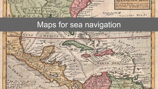
- 2. Maps for sea navigation
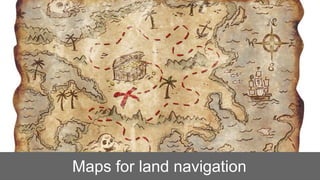
- 3. Maps for land navigation
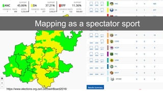
- 4. Mapping as a spectator sport https://www.elections.org.za/LGEDashBoard2016/
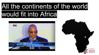
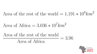
- 5. All the continents of the world would fit into Africa
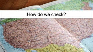
- 6. How do we check?
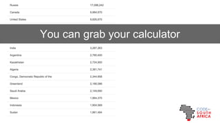
- 7. You can grab your calculator
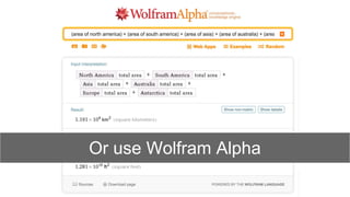
- 8. Or use Wolfram Alpha
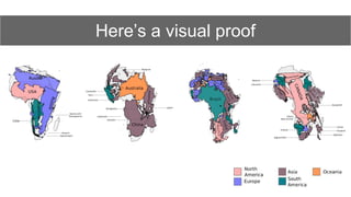
- 10. Here¡¯s a visual proof
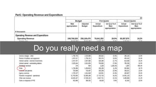
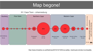
- 11. Do you really need a map
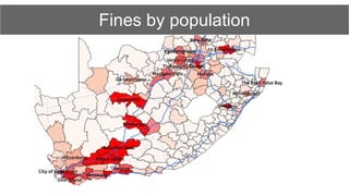
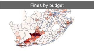
- 13. Fines by budget
- 22. http://static.code4sa.org/women-municipalities/ Female ward councillors 2016 Local Government Elections
- 24. Take home 1: our job is to communicate
- 25. Take home 2: Sometimes the best map is none at all
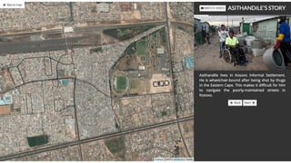
- 26. Take home 3: Don¡¯t forget the people behind the numbers
- 27. http://www.code4sa.org adi@code4sa.org Image credits: Hammer Museum Commons.wikimedia.org @soapsudtycoon @code4sa This work is licensed under a Creative Commons Attribution 4.0 International License.