
1 of 7
Download to read offline

Ad
Recommended
Ilica 09 09
Ilica 09 09Fabio Carrera
╠²
The document discusses the MOSE project from a Venetian perspective, focusing on the controversies surrounding its implementation, including environmental impacts and cost concerns. It emphasizes the project's aim to protect Venice from flooding, while addressing the criticisms regarding maintenance, funding, and the control of tourism. The document ultimately reflects on the project's potential benefits alongside the need for broader solutions to Venice's challenges, such as housing affordability and tourism effects.Carrera beyond sdi
Carrera beyond sdiFabio Carrera
╠²
The document discusses the emergence of municipal spatial data infrastructures by 2016. It argues that municipalities will transform from "hunter-gatherers" of urban data to "farmers" of municipal information. Key points include municipalities capturing all structural changes and activity snapshots at the source; adopting tools like regulations, incentives, and education to encourage data sharing; and using web services and open-source approaches to build spatial data infrastructures from the bottom-up.ECAI smart cities 2012
ECAI smart cities 2012Fabio Carrera
╠²
The document discusses the integration of intelligent agents in urban simulations and the concept of a city knowledge platform, presented at a workshop on smart cities. It emphasizes the transition from agent-based modeling to agent-oriented programming, highlighting citizens' roles as sensors and their interactions with urban structures. Key topics include the use of technology for real-time data updates, dynamic crowd simulations, and the influence of gradients in urban environments.Citizen apps
Citizen appsFabio Carrera
╠²
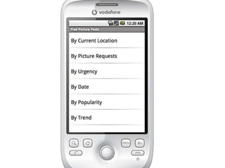
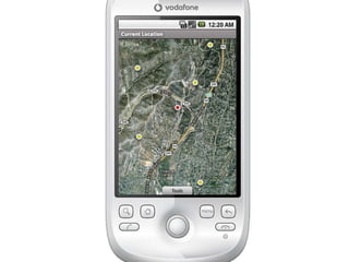
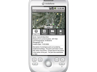
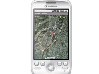
This document appears to be notes from a conference on mobile technologies for citizen science. It lists several projects and organizations that are using mobile apps and devices to collect field data for citizen science initiatives, including projects focused on parking, potholes, taxis, street signs, and more. The notes also list contact information for individuals from organizations like NASA, the City of Boston, and others working on related mobile technology projects."Monuments in Peril: Venice" at the Clark Museum, Williamstown, MA
"Monuments in Peril: Venice" at the Clark Museum, Williamstown, MAFabio Carrera
╠²
The document discusses the issues facing Venice, including rising water levels from acqua alta floods and overtourism. Specifically, it examines what is most in peril - the city's monuments, inhabitants, or quality of life. While a flood barrier system may help protect monuments, it is an expensive temporary solution that does little to address the root causes of Venice's decline, which include too many tourists and the exodus of residents. The real threat facing Venice is the loss of its cultural identity and livability for locals.Ucl
UclFabio Carrera
╠²
The document discusses the concept of "City Knowledge" which promotes transforming municipalities from collectors of urban data to farmers of municipal information. It argues that municipalities should actively capture and manage information about structures and activities within their boundaries using their existing tools of ownership, regulation, incentives, education, rights management, and mitigation. This "data farming" approach would allow municipalities to develop detailed spatial data infrastructures and share information through open-source web services.Conoscenza e condivisione
Conoscenza e condivisioneFabio Carrera
╠²
Il documento discute la gestione e la valorizzazione di Venezia e della sua laguna come patrimonio dell'umanit├Ā Unesco, evidenziando l'importanza della conoscenza condivisa e delle prospettive a breve, medio e lungo termine. Propone l'utilizzo di strumenti innovativi come piattaforme di cloud computing e applicazioni interattive per migliorare la gestione e il monitoraggio della citt├Ā. Sottolinea infine il ruolo degli agenti autonomi e del data sharing per promuovere un cambiamento positivo nelle politiche urbane.Google tools for WPI IQPs
Google tools for WPI IQPsFabio Carrera
╠²
The document outlines updates related to project centers associated with WPI, including various tools and accounts such as Google Sites, Google Drive, and other resources for team organization and sharing. It emphasizes the individual Google accounts for each team and mentions the specific sites and storage available. Additional Google tools and video resources are also referenced as part of ongoing project management and communication strategies.Venice Project Center 25th anniversary
Venice Project Center 25th anniversaryFabio Carrera
╠²
The Venice Project Center was created in 1988 and has since involved over 650 students working on 180 projects. Over its 25 years it has made numerous significant contributions to understanding Venice, including several projects and tools that have provided long-lasting benefits to the city. Through its impactful research projects, it has gained worldwide recognition for improving domains like canal maintenance, public art conservation, and mobility and environmental management in Venice.UCL - Future Cities
UCL - Future CitiesFabio Carrera
╠²
This document discusses how simple software agents can help manage smart cities. It proposes using agents to represent individual urban elements like buildings, infrastructure and citizen activities. Agents could help cities transition from just collecting urban data to actively "farming" and reusing municipal information. The document provides examples of how agents could help with tasks like managing public art/monuments, coordinating streetlight repairs based on citizen reports, and resolving data issues between city departments. Developing agent-based applications is presented as a way to apply complexity theory and make cities more participatory, adaptive and knowledge-driven.StreetBump - The total crowdsourcing of a pothole mapping app
StreetBump - The total crowdsourcing of a pothole mapping app Fabio Carrera
╠²
This document summarizes the history and development of the crowdsourced pothole mapping app StreetBump. It describes how earlier projects in Venice and Boston that mapped turbulence and potholes respectively led to the creation of StreetBump, which uses smartphone sensors to automatically detect and map road bumps. StreetBump has been crowdsourced at every stage of its development, from students and open source contributions to a $25,000 challenge to improve its algorithms. It has now mapped potholes for many cities based on data from over 10,000 app downloads and thousands of contributors.Ucl oct 2012
Ucl oct 2012Fabio Carrera
╠²
The document discusses the City Knowledge Platform, which aims to transform cities from "hunter-gatherers" of urban data to "farmers" of municipal information. It presents City Knowledge as an emergent information infrastructure that can support urban maintenance, management, and planning. The platform treats urban information as a type of infrastructure and uses principles of complexity science, modeling cities as complex adaptive systems and representing urban entities as agents. It demonstrates collecting and connecting legacy data, automatic sensors, and mobile apps to build the information infrastructure.Citizensourcing: from StreetBump to DEW (ESA 2011)
Citizensourcing: from StreetBump to DEW (ESA 2011)Fabio Carrera
╠²
This document discusses two citizen science apps: StreetBump and DEW. StreetBump uses smartphone sensors to detect potholes to help cities prioritize road repairs. DEW allows users to upload geotagged photos to monitor environmental conditions for agencies like NASA. The document outlines features of each app, limitations like battery drain, and upcoming features like in-app data extraction and change measurement. It proposes ideas like allowing users to select citizen science contributions and receive personalized feedback to better engage participants.Crowdfunding the preservation of Venetian public art
Crowdfunding the preservation of Venetian public artFabio Carrera
╠²
This document summarizes Fabio Carrera's presentation on developing a crowdfunding initiative called PreserVenice to fund the conservation of Venice's 7,027 pieces of public art. The project would create an online database and mobile app called PreserVenice that catalogs each artifact, assesses conservation priorities and costs, and enables public crowdfunding of conservation projects through microdonations. The goal is to harness public engagement and funding to preserve Venice's material cultural heritage for future generations.Sociocracy sfx
Sociocracy sfxFabio Carrera
╠²
Sociocracy is a self-organizing governance model that applies complexity theory to organizational structure and decision-making. It was developed in the early 1800s and uses principles of consent-based decisions, semi-autonomous circles for different parts of the organization, connections between circles through double-linking, and consent-based elections. Sociocracy has been adopted by many European and US companies, non-profits, and governments and is based on inclusive decision-making through rounds and resolving all objections.Ecological Society of America - Austin 2011
Ecological Society of America - Austin 2011Fabio Carrera
╠²
This document summarizes two citizen science projects called StreetBump and DEW App. StreetBump uses smartphones to detect road bumps in Boston and helps prioritize road repairs. It has limitations around battery drain and privacy. The DEW App was created by NASA to allow citizens to upload geotagged photos to monitor environmental changes. It has features like automatic orientation and upcoming additions like in-field questions and image analysis. The document concludes with ideas for two new projects called SensorDomo and CitizenPipe that could further engage citizens in science.Urban agents
Urban agentsFabio Carrera
╠²
The document discusses the concept of "City Knowledge" which promotes transforming municipalities from collectors of urban data to farmers of municipal information. It describes how municipalities can use their six tools of implementation and data collection (ownership & operation, regulation, incentives/disincentives, education & information, rights swapping, mitigation & compensation) in creative ways to "farm" municipal data on an ongoing basis through techniques like "birth certificates" and establishing a municipal spatial data infrastructure.Carrera glascock urisa_06
Carrera glascock urisa_06Fabio Carrera
╠²
The document summarizes presentations given by Fabio Carrera and Bryan Glascock about city knowledge applications in London, Boston, and Venice. It discusses how municipalities can "farm" urban data by adopting internal mechanisms to gather their own data and extract informational returns from all internal processes. It also outlines six tools (ownership and operation, regulation, incentives/disincentives, education and information, rights swapping, and mitigation and compensation) that municipalities can use to systematically gather and manage urban information.Umds presentation
Umds presentationFabio Carrera
╠²
The document discusses implementing a "City Knowledge" approach in the London Borough of Merton to help the borough achieve its target of reducing carbon dioxide emissions by 15% by 2015. It outlines Merton's current approaches to reducing emissions from buildings and promoting low-carbon solutions. It then introduces City Knowledge as an emergent information infrastructure that can help overcome challenges around data management and move municipalities from "hunter-gatherers" of data to "farmers" of information. Key aspects of City Knowledge discussed include organizing existing municipal data, closing data loops, and leveraging geographic indexing and a web-based system called LOUIS.AgentsCloud - Paris 6
AgentsCloud - Paris 6Fabio Carrera
╠²
The document discusses the work and initiatives of the Venice Project Center, focusing on the development of autonomous urban agents and mobile cloud sourcing for urban decision-making. It highlights various projects, grants, and tools related to urban information management and data collection, employing participatory methods to engage municipalities and citizens. The emphasis is on transforming cities into smarter environments through innovation and leveraging self-interest for community contribution.NM MPO Meeting
NM MPO MeetingFabio Carrera
╠²
The Santa Fe Complex is a nonprofit research lab in Santa Fe, New Mexico that fosters collaborations across science, technology, and art. It hosts a community workshop for project-based work in applied complexity. The Worcester Polytechnic Institute operates a project center at the Santa Fe Complex where students work on interdisciplinary projects in areas like sensing, visualization, modeling, and interactive decision-making. Twenty-four students will be involved in projects at the Santa Fe center from March to April 2011.Urban Agents and Citizen Apps
Urban Agents and Citizen AppsFabio Carrera
╠²
This document summarizes Fabio Carrera's research interests and projects related to developing an "Ambient Urban Platform" using autonomous agents and citizen apps for interactive urban planning. Some of the key projects discussed are the Venice Project Center, City Knowledge/City Lab, Santa Fe Project Center, Digital Earth Watch (DEW) project with NASA, and StreetBUMP project with the City of Boston. The goal is to develop a platform that integrates crowdsourcing data from mobile apps, sensors, and citizens to model and visualize urban systems and enable participatory decision-making.Participatory Interactive Urban Modeling (St. Mike's)
Participatory Interactive Urban Modeling (St. Mike's)Fabio Carrera
╠²
This document discusses using interactive urban modeling to analyze potential applications for St. Michael's Drive. It introduces complex adaptive systems modeling and agent-based modeling approaches. The Santa Fe Ambient Platform is proposed as a way to make models permanently available online to inform municipal decisions, encourage public participation, and support education. Examples of applications include traffic modeling, wildfire evacuation modeling, and public transportation modeling. The document suggests using these approaches to conduct interactive impact analyses of different design scenarios for St. Michael's Drive, such as intersection improvements, road modifications, and parking locations.CK_Long_tail
CK_Long_tailFabio Carrera
╠²
The document discusses the concept of "City Knowledge" which promotes municipalities transforming from "hunter-gatherers" of urban data to "farmers" of municipal information. It argues municipalities should utilize their six tools of implementation and data collection to "farm" data on an ongoing basis from within and outside entities. This would allow municipalities to continuously capture changes and backlog information to develop robust municipal spatial data infrastructures and share data through web services. It notes most opportunities are in smaller, "long tail" cities and targeting change sources and processes over time could fully capture information.Presentazione Traffico Comune
Presentazione Traffico ComuneFabio Carrera
╠²
The document summarizes the history and goals of several projects aimed at managing water traffic and dock use in Venice, Italy. It discusses the MOBILIS project which includes measures to manage permanent and temporary dock parking (Measure 10.2) and water traffic (Measure 12.6). The goals are to prioritize dock use, minimize obstacles to traffic, manage pre-assigned and temporary dock permits, and design an online parking management system. It also covers monitoring and modeling of water traffic levels and waves caused by boats to reduce their impact.Ucgis Summer 09 Final
Ucgis Summer 09 FinalFabio Carrera
╠²
The document discusses autonomous urban agents and a Santa Fe approach to modeling cities. It describes using complexity theory and autonomous agent modeling to simulate urban dynamics and crowds. It provides examples of using these techniques to model crowd evacuations, pedestrian flows, and traffic patterns. The approach aims to capture both the stable structural elements of cities as well as the more dynamic human activities to build a model of urban "reality."Miriam Cho: Transforming Healthcare through Visionary Leadership
Miriam Cho: Transforming Healthcare through Visionary Leadershipjessicashaw101998
╠²
Miriam Cho, President and Chief Pharmacy Officer (CPO) of MAC Rx, LLC, has extensive experience in the LTC and healthcare sectors. Miriam is skilled in various areas, including healthcare management, pharmacy operations, cost management, Medicare Part D, cardiopulmonary resuscitation (CPR), pharmacy consulting, and clinical pharmacology. She holds a Doctor of Pharmacy (Pharm.D.) degree from Midwestern University in Illinois, showcasing her strong background in healthcare services.Oleksandr Osypenko: Defining PMO Structure and Governance (UA)
Oleksandr Osypenko: Defining PMO Structure and Governance (UA)Lviv Startup Club
╠²
Oleksandr Osypenko: Defining PMO Structure and Governance (UA)
LemBS PMO School 2025
Website ŌĆō https://lembs.com/pmoschool
Youtube ŌĆō https://www.youtube.com/startuplviv
FB ŌĆō https://www.facebook.com/pmdayconference More Related Content
More from Fabio Carrera (20)
Google tools for WPI IQPs
Google tools for WPI IQPsFabio Carrera
╠²
The document outlines updates related to project centers associated with WPI, including various tools and accounts such as Google Sites, Google Drive, and other resources for team organization and sharing. It emphasizes the individual Google accounts for each team and mentions the specific sites and storage available. Additional Google tools and video resources are also referenced as part of ongoing project management and communication strategies.Venice Project Center 25th anniversary
Venice Project Center 25th anniversaryFabio Carrera
╠²
The Venice Project Center was created in 1988 and has since involved over 650 students working on 180 projects. Over its 25 years it has made numerous significant contributions to understanding Venice, including several projects and tools that have provided long-lasting benefits to the city. Through its impactful research projects, it has gained worldwide recognition for improving domains like canal maintenance, public art conservation, and mobility and environmental management in Venice.UCL - Future Cities
UCL - Future CitiesFabio Carrera
╠²
This document discusses how simple software agents can help manage smart cities. It proposes using agents to represent individual urban elements like buildings, infrastructure and citizen activities. Agents could help cities transition from just collecting urban data to actively "farming" and reusing municipal information. The document provides examples of how agents could help with tasks like managing public art/monuments, coordinating streetlight repairs based on citizen reports, and resolving data issues between city departments. Developing agent-based applications is presented as a way to apply complexity theory and make cities more participatory, adaptive and knowledge-driven.StreetBump - The total crowdsourcing of a pothole mapping app
StreetBump - The total crowdsourcing of a pothole mapping app Fabio Carrera
╠²
This document summarizes the history and development of the crowdsourced pothole mapping app StreetBump. It describes how earlier projects in Venice and Boston that mapped turbulence and potholes respectively led to the creation of StreetBump, which uses smartphone sensors to automatically detect and map road bumps. StreetBump has been crowdsourced at every stage of its development, from students and open source contributions to a $25,000 challenge to improve its algorithms. It has now mapped potholes for many cities based on data from over 10,000 app downloads and thousands of contributors.Ucl oct 2012
Ucl oct 2012Fabio Carrera
╠²
The document discusses the City Knowledge Platform, which aims to transform cities from "hunter-gatherers" of urban data to "farmers" of municipal information. It presents City Knowledge as an emergent information infrastructure that can support urban maintenance, management, and planning. The platform treats urban information as a type of infrastructure and uses principles of complexity science, modeling cities as complex adaptive systems and representing urban entities as agents. It demonstrates collecting and connecting legacy data, automatic sensors, and mobile apps to build the information infrastructure.Citizensourcing: from StreetBump to DEW (ESA 2011)
Citizensourcing: from StreetBump to DEW (ESA 2011)Fabio Carrera
╠²
This document discusses two citizen science apps: StreetBump and DEW. StreetBump uses smartphone sensors to detect potholes to help cities prioritize road repairs. DEW allows users to upload geotagged photos to monitor environmental conditions for agencies like NASA. The document outlines features of each app, limitations like battery drain, and upcoming features like in-app data extraction and change measurement. It proposes ideas like allowing users to select citizen science contributions and receive personalized feedback to better engage participants.Crowdfunding the preservation of Venetian public art
Crowdfunding the preservation of Venetian public artFabio Carrera
╠²
This document summarizes Fabio Carrera's presentation on developing a crowdfunding initiative called PreserVenice to fund the conservation of Venice's 7,027 pieces of public art. The project would create an online database and mobile app called PreserVenice that catalogs each artifact, assesses conservation priorities and costs, and enables public crowdfunding of conservation projects through microdonations. The goal is to harness public engagement and funding to preserve Venice's material cultural heritage for future generations.Sociocracy sfx
Sociocracy sfxFabio Carrera
╠²
Sociocracy is a self-organizing governance model that applies complexity theory to organizational structure and decision-making. It was developed in the early 1800s and uses principles of consent-based decisions, semi-autonomous circles for different parts of the organization, connections between circles through double-linking, and consent-based elections. Sociocracy has been adopted by many European and US companies, non-profits, and governments and is based on inclusive decision-making through rounds and resolving all objections.Ecological Society of America - Austin 2011
Ecological Society of America - Austin 2011Fabio Carrera
╠²
This document summarizes two citizen science projects called StreetBump and DEW App. StreetBump uses smartphones to detect road bumps in Boston and helps prioritize road repairs. It has limitations around battery drain and privacy. The DEW App was created by NASA to allow citizens to upload geotagged photos to monitor environmental changes. It has features like automatic orientation and upcoming additions like in-field questions and image analysis. The document concludes with ideas for two new projects called SensorDomo and CitizenPipe that could further engage citizens in science.Urban agents
Urban agentsFabio Carrera
╠²
The document discusses the concept of "City Knowledge" which promotes transforming municipalities from collectors of urban data to farmers of municipal information. It describes how municipalities can use their six tools of implementation and data collection (ownership & operation, regulation, incentives/disincentives, education & information, rights swapping, mitigation & compensation) in creative ways to "farm" municipal data on an ongoing basis through techniques like "birth certificates" and establishing a municipal spatial data infrastructure.Carrera glascock urisa_06
Carrera glascock urisa_06Fabio Carrera
╠²
The document summarizes presentations given by Fabio Carrera and Bryan Glascock about city knowledge applications in London, Boston, and Venice. It discusses how municipalities can "farm" urban data by adopting internal mechanisms to gather their own data and extract informational returns from all internal processes. It also outlines six tools (ownership and operation, regulation, incentives/disincentives, education and information, rights swapping, and mitigation and compensation) that municipalities can use to systematically gather and manage urban information.Umds presentation
Umds presentationFabio Carrera
╠²
The document discusses implementing a "City Knowledge" approach in the London Borough of Merton to help the borough achieve its target of reducing carbon dioxide emissions by 15% by 2015. It outlines Merton's current approaches to reducing emissions from buildings and promoting low-carbon solutions. It then introduces City Knowledge as an emergent information infrastructure that can help overcome challenges around data management and move municipalities from "hunter-gatherers" of data to "farmers" of information. Key aspects of City Knowledge discussed include organizing existing municipal data, closing data loops, and leveraging geographic indexing and a web-based system called LOUIS.AgentsCloud - Paris 6
AgentsCloud - Paris 6Fabio Carrera
╠²
The document discusses the work and initiatives of the Venice Project Center, focusing on the development of autonomous urban agents and mobile cloud sourcing for urban decision-making. It highlights various projects, grants, and tools related to urban information management and data collection, employing participatory methods to engage municipalities and citizens. The emphasis is on transforming cities into smarter environments through innovation and leveraging self-interest for community contribution.NM MPO Meeting
NM MPO MeetingFabio Carrera
╠²
The Santa Fe Complex is a nonprofit research lab in Santa Fe, New Mexico that fosters collaborations across science, technology, and art. It hosts a community workshop for project-based work in applied complexity. The Worcester Polytechnic Institute operates a project center at the Santa Fe Complex where students work on interdisciplinary projects in areas like sensing, visualization, modeling, and interactive decision-making. Twenty-four students will be involved in projects at the Santa Fe center from March to April 2011.Urban Agents and Citizen Apps
Urban Agents and Citizen AppsFabio Carrera
╠²
This document summarizes Fabio Carrera's research interests and projects related to developing an "Ambient Urban Platform" using autonomous agents and citizen apps for interactive urban planning. Some of the key projects discussed are the Venice Project Center, City Knowledge/City Lab, Santa Fe Project Center, Digital Earth Watch (DEW) project with NASA, and StreetBUMP project with the City of Boston. The goal is to develop a platform that integrates crowdsourcing data from mobile apps, sensors, and citizens to model and visualize urban systems and enable participatory decision-making.Participatory Interactive Urban Modeling (St. Mike's)
Participatory Interactive Urban Modeling (St. Mike's)Fabio Carrera
╠²
This document discusses using interactive urban modeling to analyze potential applications for St. Michael's Drive. It introduces complex adaptive systems modeling and agent-based modeling approaches. The Santa Fe Ambient Platform is proposed as a way to make models permanently available online to inform municipal decisions, encourage public participation, and support education. Examples of applications include traffic modeling, wildfire evacuation modeling, and public transportation modeling. The document suggests using these approaches to conduct interactive impact analyses of different design scenarios for St. Michael's Drive, such as intersection improvements, road modifications, and parking locations.CK_Long_tail
CK_Long_tailFabio Carrera
╠²
The document discusses the concept of "City Knowledge" which promotes municipalities transforming from "hunter-gatherers" of urban data to "farmers" of municipal information. It argues municipalities should utilize their six tools of implementation and data collection to "farm" data on an ongoing basis from within and outside entities. This would allow municipalities to continuously capture changes and backlog information to develop robust municipal spatial data infrastructures and share data through web services. It notes most opportunities are in smaller, "long tail" cities and targeting change sources and processes over time could fully capture information.Presentazione Traffico Comune
Presentazione Traffico ComuneFabio Carrera
╠²
The document summarizes the history and goals of several projects aimed at managing water traffic and dock use in Venice, Italy. It discusses the MOBILIS project which includes measures to manage permanent and temporary dock parking (Measure 10.2) and water traffic (Measure 12.6). The goals are to prioritize dock use, minimize obstacles to traffic, manage pre-assigned and temporary dock permits, and design an online parking management system. It also covers monitoring and modeling of water traffic levels and waves caused by boats to reduce their impact.Ucgis Summer 09 Final
Ucgis Summer 09 FinalFabio Carrera
╠²
The document discusses autonomous urban agents and a Santa Fe approach to modeling cities. It describes using complexity theory and autonomous agent modeling to simulate urban dynamics and crowds. It provides examples of using these techniques to model crowd evacuations, pedestrian flows, and traffic patterns. The approach aims to capture both the stable structural elements of cities as well as the more dynamic human activities to build a model of urban "reality."Recently uploaded (20)
Miriam Cho: Transforming Healthcare through Visionary Leadership
Miriam Cho: Transforming Healthcare through Visionary Leadershipjessicashaw101998
╠²
Miriam Cho, President and Chief Pharmacy Officer (CPO) of MAC Rx, LLC, has extensive experience in the LTC and healthcare sectors. Miriam is skilled in various areas, including healthcare management, pharmacy operations, cost management, Medicare Part D, cardiopulmonary resuscitation (CPR), pharmacy consulting, and clinical pharmacology. She holds a Doctor of Pharmacy (Pharm.D.) degree from Midwestern University in Illinois, showcasing her strong background in healthcare services.Oleksandr Osypenko: Defining PMO Structure and Governance (UA)
Oleksandr Osypenko: Defining PMO Structure and Governance (UA)Lviv Startup Club
╠²
Oleksandr Osypenko: Defining PMO Structure and Governance (UA)
LemBS PMO School 2025
Website ŌĆō https://lembs.com/pmoschool
Youtube ŌĆō https://www.youtube.com/startuplviv
FB ŌĆō https://www.facebook.com/pmdayconference Stuart Frost - The Chief Executive Officer Of Geminos
Stuart Frost - The Chief Executive Officer Of GeminosStuart Frost
╠²
Stuart Frost, CEO of Geminos, is a pioneering force in the IIoT and data analytics industry. After graduating from Nottingham University in Electronic and Computer Engineering, Stu founded SELECT Software Tools and led it through a NASDAQ IPO in 1996. His ventures in the IIoT space include Maana, OspreyData, and SWARM. Book - Behavioral finance and wealth management(1).pdf
Book - Behavioral finance and wealth management(1).pdfGamingwithUBAID
╠²
Book - Behavioral finance and wealth management(1).pdfThe Role of Business Process Tools in Driving Strategic Agility
The Role of Business Process Tools in Driving Strategic AgilityRUPAL AGARWAL
╠²
This presentation explores how modern business process tools empower organizations to adapt quickly to change, align operations with strategic goals, and enhance decision-making. Learn how BPM software, workflow automation, and real-time analytics support agility in a rapidly evolving business landscape.Redefining Business Experiences: The Role of a Corporate Event Management Com...
Redefining Business Experiences: The Role of a Corporate Event Management Com...Be Executive Events
╠²
In the world of business, events are no longer just formalities. They are strategic platforms that drive brand visibility, strengthen partnerships, boost employee morale, and deliver critical business messages. From grand product launches and annual conferences to executive retreats and networking summits, events serve as essential milestones in a companyŌĆÖs growth journey.IEA_Press_Release_Tullow_Agreement-16-6-2025-1.pdf
IEA_Press_Release_Tullow_Agreement-16-6-2025-1.pdfbusinessweekghana
╠²
DonŌĆÖt extend petroleum licenses of Tullow ŌĆō IEA appeals to GovŌĆÖtIBX Prospective Consultant Information Pack
IBX Prospective Consultant Information PackIBX Daya Nusantara
╠²
How to apply to join the IBX International Business Network (IBX Network)
To apply, you need to provide a completed ŌĆśProspective Consultant Profile (PCP)ŌĆÖ which can be downloaded from our web site.
It would also aid your application if you were to provide a brief summary of the type of clients that you can introduce.
If you have any questions, please feel free to contact us at info [at] ibx.co.id
Our team can speak several languages and will be pleased to assist you.
About IBX: Indonesia Business Exchange (ŌĆ£IBXŌĆØ), PT IBX Daya Nusantara, a joint venture of BXI Capital and Patria Pacific Group (Patria Holding), is a Consultant and Business Dealer (or Intermediary; Broker) service company that buys and sells business and companies for its clients, facilitates projects, improves utilization, and asset liquidity strategies, as well as suppliers and trades various products. We are connected to the ecosystem and global operating network for business expansion, investment, and cross-industry transactions. IBX is also trusted as a strategic partner for access to private capital fund facilities, and market entry strategies in Indonesia.
BMGI India Addressing Strategic, Innovative, and Operational Problems at Core...
BMGI India Addressing Strategic, Innovative, and Operational Problems at Core...Naresh Raisinghani
╠²
Discover how BMGI India empowers businesses to solve core challenges, drive sustainable growth, and achieve real transformation through proven frameworks and deep industry expertise.
https://www.bmgindia.com¤¦¬ JIS Z 8901 Class 8 Kanto Loam .pdf
¤¦¬ JIS Z 8901 Class 8 Kanto Loam .pdfParticle Powder
╠²
High-Performance Soil-Based Test Dust for Rigorous Filtration & Environmental Testing
From Particle Powder ŌĆō Leaders in Certified Test Dust Solutions
JIS Z 8901 Class 8 Kanto Loam is designed to simulate real-world soil contamination, providing a high-accuracy dust profile ideal for filtration systems and industrial component stress testing.
¤ō▒ WhatsApp / Call: +91 8076861957
¤ō¦ Email: inquiry_fec@yahoo.com
¤īÉ Website: particlepowder.comVisualizing SOPs with Flow Charts: A Step-by-Step Guide to Streamlining Stand...
Visualizing SOPs with Flow Charts: A Step-by-Step Guide to Streamlining Stand...RUPAL AGARWAL
╠²
Learn how to transform complex Standard Operating Procedures (SOPs) into clear, easy-to-follow flow charts. This PowerPoint presentation (PPT) covers the benefits of visual SOPs, best practices for designing flowcharts, and real-world examples to improve efficiency and compliance in your organization. Perfect for operations managers, quality assurance teams, and process improvement specialists.Programmatic Advertising in Healthcare - Harvee Health.pptx
Programmatic Advertising in Healthcare - Harvee Health.pptxhealthcareharvee
╠²
Discover how programmatic advertising transforms healthcare marketing with precision targeting, real examples, ROI data, and expert strategies for success. For more info visit: https://www.harveehealthcare.com/blog/what-is-programmatic-advertising-how-to-use-it-in-healthcare/chapter 9 leadership qualityies university of windsor
chapter 9 leadership qualityies university of windsorzamananalyst29
╠²
Chapter 9 leadership qualities university of WindsorBOURNS POTENTIOMETER Provide You Precision
BOURNS POTENTIOMETER Provide You Precisionsmidmart
╠²
Bourns potentiometers are high-quality variable resistors designed for precision control in a wide range of electronic applications. Known for their durability, accuracy, and reliability, Bourns potentiometers are ideal for adjusting signal levels, tuning circuits, or setting reference voltages in industrial, automotive, and consumer electronics.
Available in rotary and slide variants, these components offer excellent repeatability, smooth operation, and long mechanical life, making them a trusted choice for engineers and designers worldwide.
Sathesh Murthy_ Mastering the Art of Communication for Business Success.pdf
Sathesh Murthy_ Mastering the Art of Communication for Business Success.pdfEnterprise world
╠²
One such leader is Sathesh Murthy, Senior Vice President and General Manager at RingCentral India, who embodies these principles in his approach.PT IBX Daya Nusantara Company Profile 2025
PT IBX Daya Nusantara Company Profile 2025IBX Daya Nusantara
╠²
Indonesia Business Exchange ("IBX"), PT BX Daya NusantaraŌĆöa subsidiary of BXI Capital and member of Patria Pacific Group (Patria Holding), is a Consultant and Business Dealer (or Intermediary; Broker) company that buys and sells business and companies for its clients, facilitates projects, improves utilization, and asset liquidity strategies, as well as suppliers and trades various products. We are connected to the ecosystem and global operating network for business expansion, investment, and cross-industry transactions. IBX is also trusted as a strategic partner for access to private capital fund facilities, and market entry strategies in Indonesia.
IBX is committed to bringing together the most critical business infrastructure and global networks into a centralized ecosystem that enabling businesses to scale, innovate, and generate strong returns for our stakeholders and society at large.The Key Cultural Role of PuneŌĆÖs Shivsrushti
The Key Cultural Role of PuneŌĆÖs Shivsrushtikapoorgita1991
╠²
Shivsrushti, a heritage park in Pune envisioned by Babasaheb Purandare, offers a powerful blend of immersive storytelling, historical accuracy, and civic education centered around the life and values of Chhatrapati Shivaji Maharaj. Through lifelike exhibits and recreated experiences, it brings history to life for people of all ages, encouraging reflection on leadership, inclusivity, and ethical governance. The Abhay Bhutada Foundation has played a pivotal role in expanding access to Shivsrushti by supporting educational visits for underprivileged students, ensuring that this cultural treasure is shared widely and meaningfully. More than a tribute to the past, Shivsrushti serves as a public model for how history can inspire civic pride and social unity in contemporary India.
Redefining Business Experiences: The Role of a Corporate Event Management Com...
Redefining Business Experiences: The Role of a Corporate Event Management Com...Be Executive Events
╠²
BMGI India Addressing Strategic, Innovative, and Operational Problems at Core...
BMGI India Addressing Strategic, Innovative, and Operational Problems at Core...Naresh Raisinghani
╠²
Ad