10 modis-–Є–є–љ –Љ—Н–і—Н—Н–≥ –∞—И–Є–≥–ї–∞–љ –Њ–є–љ —В”©—А–ї–Є–є–≥ —В–Њ–і–Њ—А—Е–Њ–є–ї–Њ—Е –±–Њ–ї–Њ–Љ–ґ - –≥.–љ–∞–љ–і–Є–љ-—Н—А–і—Н–љ—Н
0 likes378 views


More Related Content
Similar to 10 modis-–Є–є–љ –Љ—Н–і—Н—Н–≥ –∞—И–Є–≥–ї–∞–љ –Њ–є–љ —В”©—А–ї–Є–є–≥ —В–Њ–і–Њ—А—Е–Њ–є–ї–Њ—Е –±–Њ–ї–Њ–Љ–ґ - –≥.–љ–∞–љ–і–Є–љ-—Н—А–і—Н–љ—Н (15)
More from GeoMedeelel (20)


10 modis-–Є–є–љ –Љ—Н–і—Н—Н–≥ –∞—И–Є–≥–ї–∞–љ –Њ–є–љ —В”©—А–ї–Є–є–≥ —В–Њ–і–Њ—А—Е–Њ–є–ї–Њ—Е –±–Њ–ї–Њ–Љ–ґ - –≥.–љ–∞–љ–і–Є–љ-—Н—А–і—Н–љ—Н
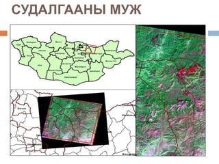
- 1. вАЬMODIS-–Ш–Щ–Э –Ь–≠–Ф–≠–≠–У –Р–®–Ш–У–Ы–Р–Э –Ю–Щ–Э –Ґ”®–†–Ы–Ш–Щ–У –Ґ–Ю–Ф–Ю–†–•–Ю–Щ–Ы–Ю–• –С–Ю–Ы–Ю–Ь–ЦвАЭ –У. –Э–∞–љ–і–Є–љ-–≠—А–і—Н–љ—Н –С–∞–є–≥–∞–ї—М –Њ—А—З–љ—Л –Љ—Н–і—Н—Н–ї–ї–Є–є–љ —В”©–≤ –Ч–∞–є–љ–∞–∞—Б —В–∞–љ–і–∞–љ —Б—Г–і–ї–∞–ї—Л–љ –Є–љ–ґ–µ–љ–µ—А –£–ї–∞–∞–љ–±–∞–∞—В–∞—А 2010 –Њ–љ
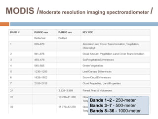
- 2. MODIS /Moderate resolution imaging spectroradiometer / пВ§ 250 –Љ-—Н—Н—Б 1 k–Љ-–Є–є–љ –Њ—А–Њ–љ –Ј–∞–є–љ —П–ї–≥–∞—Е —З–∞–і–≤–∞—А—В–∞–є. пВ§ 0.4 ¬µm -14.4 ¬µm –і–Њ–ї–≥–Є–Њ–љ—Л —Г—А—В—В–∞–є 36 —Б–њ–µ–Ї—В—А–Є–є–љ —Б—Г–≤–∞–≥—В–∞–є. Bands 1вАУ2 - 250-meter Bands 3вАУ7 - 500-meter Bands 8вАУ36 - 1000-meter
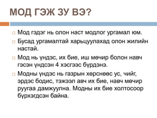
- 3. –Ь–Ю–Ф –У–≠–Ц –Ч–£ –Т–≠? пВ® –Ь–Њ–і –≥—Н–і—Н–≥ –љ—М –Њ–ї–Њ–љ –љ–∞—Б—В –Љ–Њ–і–ї–Њ–≥ —Г—А–≥–∞–Љ–∞–ї —О–Љ. пВ® –С—Г—Б–∞–і —Г—А–≥–∞–Љ–∞–ї—В–∞–є —Е–∞—А—М—Ж—Г—Г–ї–∞—Е–∞–і –Њ–ї–Њ–љ –ґ–Є–ї–Є–є–љ –љ–∞—Б—В–∞–є. пВ® –Ь–Њ–і –љ—М “ѓ–љ–і—Н—Б, –Є—Е –±–Є–µ, –Є—И –Љ”©—З–Є—А –±–Њ–ї–Њ–љ –љ–∞–≤—З –≥—Н—Б—Н–љ “ѓ–љ–і—Б—Н–љ 4 —Е—Н—Б–≥—Н—Н—Б –±“ѓ—А–і—Н–љ—Н. пВ® –Ь–Њ–і–љ—Л “ѓ–љ–і—Н—Б –љ—М –≥–∞–Ј—А—Л–љ —Е”©—А—Б–љ”©”©—Б —Г—Б, —З–Є–є–≥, —Н—А–і—Н—Б –±–Њ–і–Є—Б, —В—Н–ґ—Н—Н–ї –∞–≤—З –Є—Е –±–Є–µ, –љ–∞–≤—З –Љ”©—З–Є—А —А—Г—Г–≥–∞–∞ –і–∞–Љ–ґ—Г—Г–ї–љ–∞. –Ь–Њ–і–љ—Л –Є—Е –±–Є–µ —Е–Њ–ї—В–Њ—Б–Њ–Њ—А –±“ѓ—А—Е—Н–≥–і—Б—Н–љ –±–∞–є–љ–∞.
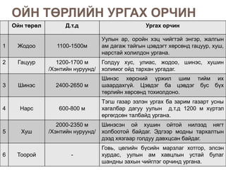
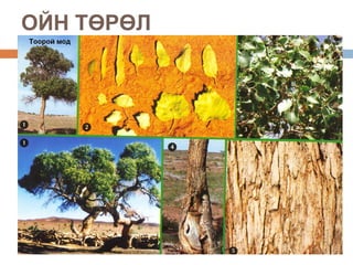
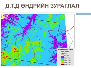
- 4. –Ю–Щ–Э –Ґ”®–†–Ы–Ш–Щ–Э –£–†–У–Р–• –Ю–†–І–Ш–Э –Ю–є–љ —В”©—А”©–ї –Ф.—В.–і –£—А–≥–∞—Е –Њ—А—З–Є–љ –£—Г–ї—Л–љ –∞—А, –Њ—А–Њ–є–љ —Е—Н—Ж —З–Є–є–≥—В—Н–є —Н–љ–≥—Н—А, –ґ–∞–ї–≥—Л–љ 1 –Ц–Њ–і–Њ–Њ 1100-1500–Љ –∞–Љ –і–∞–≥–∞–ґ —В–∞–є–≥—Л–љ —Ж—Н–≤–і—Н–≥—В —Е”©—А—Б”©–љ–і –≥–∞—Ж—Г—Г—А, —Е—Г—И, –љ–∞—А—Б—В–∞–є —Е–Њ–ї–Є–ї–і–Њ–љ —Г—А–≥–∞–љ–∞. 2 –У–∞—Ж—Г—Г—А 1200-1700 –Љ –У–Њ–ї–і—Г—Г —Е—Г—Б, —Г–ї–Є–∞—Б, –ґ–Њ–і–Њ–Њ, —И–Є–љ—Н—Б, —Е—Г—И–Є–љ /–•—Н–љ—В–Є–є–љ –љ—Г—А—Г—Г–љ–і/ —Е–Њ–ї–Є–Љ–Њ–≥ –Њ–є–і —В–∞—А—Е–∞–љ —Г—А–≥–∞–і–∞–≥. –®–Є–љ—Н—Б —Е”©—А—Б–љ–Є–є “ѓ—А–ґ–Є–ї —И–Є–Љ —В–Є–є–Љ –Є—Е 3 –®–Є–љ—Н—Б 2400-2650 –Љ —И–∞–∞—А–і–∞—Е–≥“ѓ–є. –¶—Н–≤–і—Н–≥ –±–∞ —Ж—Н–≤–і—Н–≥ –±—Г—Б –±“ѓ—Е —В”©—А–ї–Є–є–љ —Е”©—А—Б”©–љ–і —В–Њ—Е–Є–Њ–ї–і–Њ–љ–Њ. –Ґ—Н–≥—И –≥–∞–Ј–∞—А —Н–Ј–ї—Н–љ —Г—А–≥–∞—Е –±–∞ –Ј–∞—А–Є–Љ –≥–∞–Ј–∞—А—В —Г—Б–љ—Л 4 –Э–∞—А—Б 600-800 –Љ —Е–∞–≥–∞–ї–±–∞—А –і–∞–≥—Г—Г —Г—Г–ї—Л–љ –і.—В.–і 1200 –Љ —Е“ѓ—А—В—Н–ї ”©—А–≥”©–≥–і—Б”©–љ —В–∞–ї–±–∞–є–і —Г—А–≥–∞–љ–∞. 2000-2350 –Љ –®–Є–љ—Н—Б—Н–љ –Њ–є —Е—Г—И–Є–љ –Њ–є—В–Њ–є –љ–Є–ї—Н—Н–і –љ—П–≥—В 5 –•—Г—И /–•—Н–љ—В–Є–є–љ –љ—Г—А—Г—Г–љ–і/ —Е–Њ–ї–±–Њ–Њ—В–Њ–є –±–∞–є–і–∞–≥. –≠–і–≥—Н—Н—А –Љ–Њ–і–љ—Л —В–∞—А—Е–∞–ї—В—Л–љ –і—Н—Н–і —Е—П–Ј–≥–∞–∞—А –≥–Њ–ї–і—Г—Г –і–∞–≤—Е—Ж—Б–∞–љ –±–∞–є–і–∞–≥. –У–Њ–≤—М, —Ж”©–ї–Є–є–љ –±“ѓ—Б–Є–є–љ –Љ–∞—А–Ј–ї–∞–≥ —Е–Њ—В–≥–Њ—А, —Н–ї—Б—Н–љ 6 –Ґ–Њ–Њ—А–Њ–є - —Е—Г—А–і–∞—Б, —Г—Г–ї—Л–љ –∞–Љ —Е–∞–≤—Ж–ї—Л–љ —Г—Б—В–∞–є –±—Г–ї–∞–≥ —И–∞–љ–і–љ—Л –Ј–∞—Е—Л–љ —З–Є–є–≥–ї—Н–≥ –Њ—А—З–Є–љ–і —Г—А–≥–∞–љ–∞.
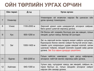
- 5. –Ю–Щ–Э –Ґ”®–†–Ы–Ш–Щ–Э –£–†–У–Р–• –Ю–†–І–Ш–Э –Ю–є–љ —В”©—А”©–ї –Ф.—В.–і –£—А–≥–∞—Е –Њ—А—З–Є–љ –£–ї–Є–∞–љ–≥–∞—А–∞–љ –Њ–є –Є—Е—Н–≤—З–ї—Н–љ –љ–∞—А—Б–∞–љ –±–∞ —И–Є–љ—Н—Б—Н–љ –Њ–є–љ 7 –£–ї–Є–∞–љ–≥–∞—А - —Г—А–≥–∞—Е –Њ—А—З–Є–љ–і —В–Њ—Е–Є–Њ–ї–і–Њ–љ–Њ. 8 –£–ї–Є–∞—Б 1100-2000 –Љ –•”©—А—Б–љ–Є–є “ѓ—А–ґ–Є–ї —И–Є–Љ —И–∞–∞—А–і–∞—Е–≥“ѓ–є, —Н–ї—Б—Н—А—Е—Н–≥ —Б–∞–є—А—Е–∞–≥, –±–∞–≥–∞ “ѓ—А–ґ–Є–ї —И–Є–Љ—В—Н–є —Е”©—А—Б”©–љ–і —Г—А–≥–∞–љ–∞. –Ю–є –±–Њ–ї–Њ–љ –Њ–є—В —Е—Н—Н—А–Є–є–љ –±“ѓ—Б–ї“ѓ“ѓ—А –і—Н—Е –∞–Љ —Е–∞–≤—Ж–∞–ї, –≥–Њ–ї—Л–љ 9 –•—Г—Б 600-1200 –Љ —Е”©–љ–і–Є–є, —Г—Г–ї—Л–љ —Е–∞–ґ—Г—Г, –±—Н–ї—Н—Н—А –Њ–є “ѓ“ѓ—Б–≥—Н–і—Н–≥. –Ч–∞–≥ –љ—М —Е”©—А—Б–љ–Є–є ”©–љ–≥”©–љ –≥–∞–і–∞—А–≥–∞ –ґ–Є–ґ–Є–≥ —Е–∞–є—А–≥–∞ —З—Г–ї—Г—Г–≥–∞–∞—А –±“ѓ—А—Е—Н–≥–і—Б—Н–љ –±–Њ–ї–Њ–љ —Е”©–љ–≥”©–љ —Б–Є–є—А—Н–≥ –±“ѓ—В—Н—Ж—В—Н–є —Н–ї—Б—Н–љ —Е”©—А—Б, 10 –Ч–∞–≥ 1000-1400 –Љ –≥–Њ–≤–Є–є–љ —Г—Г–ї—Б —Е–Њ–Њ—А–Њ–љ–і—Л–љ —Г—Г–і–∞–Љ —Е”©–љ–і–Є–є —Е–Њ–Њ–ї–Њ–є, —Е–∞—В–∞–ґ —И–∞–ї–Ј—Б–∞–љ —В–Њ–є—А–Њ–Љ, —Е”©–љ–і–Є–є —Е–Њ–Њ–ї–Њ–є–љ —Е—Г—Г—А–∞–є —Б–∞–є—А –і–∞–≥–∞–ґ —Г—А–≥–∞–љ–∞. –Ч–∞–≥ 5-—А —Б–∞—А—Л–љ –і—Г–љ–і—Г—Г—А —Ж—Н—Ж—Н–≥–ї—Н–љ—Н. –У–Њ–ї—Л–љ —З–Є–є–≥–ї—Н–≥, –љ–∞–Љ–≥–∞—А—Е–∞–≥, —Н—А—Н–≥ –і–∞–≥—Г—Г —Е–∞–є—А–≥–∞—А—Е–∞–≥, 11 –С—Г—А–≥–∞—Б 600-2200 –Љ —Н–ї—Б—Н—А—Е—Н–≥, —З–Є–є–≥—В—Н–є —Е”©–љ–≥”©–љ —Е”©—А—Б”©–љ–і —Б–∞–є–љ —Г—А–≥–∞–љ–∞. –£—Г–ї—Л–љ —Е–∞–і, —З—Г–ї—Г—Г—А—Е–∞–≥ —Е–∞–ґ—Г—Г, –∞–Љ —Е”©–љ–і–Є–є, —Б–∞–є—А—Л–љ —Н—Е, 12 –•–∞–є–ї–∞–∞—Б 640-1300 –Љ –≥–Њ—А—Е–Є –±—Г–ї–≥—Л–љ —Н—Е, –≥–Њ–ї—Л–љ —Е”©–љ–і–Є–є–љ —Н–ї—Б—Н—А—Е—Н–≥ —Б–Є–є—А—Н–≥ –љ–∞—А—Б–∞–љ –Њ–є–љ –Ј–∞—Е–∞–∞—А —Г—А–≥–∞–љ–∞.
- 7. –°–£–Ф–Р–Ы–У–Р–Р–Э–Ђ –Ч–Ю–†–Ш–Ы–У–Ю пВ® MODIS-–Є–є–љ 1 –±–∞ 2-—А —Б—Г–≤–≥–Є–є–љ –Љ—Н–і—Н—Н–≥—Н—Н—А –Њ–є–љ —В”©—А–ї–Є–є–≥ –∞–љ–≥–Є–ї–∞—Е –Ч–Њ—А–Є–ї—В—Г—Г–і: 1. 2009 –Њ–љ—Л 1-12 —Б–∞—А —Е“ѓ—А—В—Н–ї—Е —Ж—Н–ї–Љ—Н–≥ ”©–і—А–Є–є–љ –Љ—Н–і—Н—Н–љ –і—Н—Н—А –∞–љ–∞–ї–Є–Ј —Е–Є–є—Е 2. –Р–љ–≥–Є–ї—Б–∞–љ –Њ–є–љ —В”©—А–ї”©”© —Г—А–≥–∞–Љ–∞–ї–ґ–Є–ї—В—Л–љ / NDVI / –Є–љ–і–µ–Ї—Б—В—Н–є —Е–∞—А—М—Ж—Г—Г–ї–∞–ї—В —Е–Є–є—Е 3. –Ф.—В.–і ”©–љ–і—А”©”©—А –љ—М –Њ–є–љ —В”©—А–ї”©”©—А –∞–љ–≥–Є–ї–ї–∞–∞ —И–∞–ї–≥–∞—Е
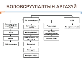
- 8. –Р–®–Ш–У–Ы–Р–°–Р–Э –Ь–≠–Ф–≠–≠, –Ь–≠–Ф–≠–≠–Ы–≠–Ы пВ® –•–Є–є–Љ—Н–ї –і–∞–≥—Г—Г–ї—Л–љ –Љ—Н–і—Н—Н - MODIS-–Є–є–љ 2009 –Њ–љ—Л 1-12 —Б–∞—А —Е“ѓ—А—В—Н–ї—Е —Ж—Н–ї–Љ—Н–≥ ”©–і—А–Є–є–љ 21 –Љ—Н–і—Н—Н - Landsat —Е–Є–є–Љ—Н–ї –і–∞–≥—Г—Г–ї—Л–љ 2009 –Њ–љ—Л 5, 6, 9-—А —Б–∞—А—Л–љ 3 –Љ—Н–і—Н—Н /Path130 row 26/ пВ® –°—Н–і—Н–≤—З–Є–ї—Б—Н–љ –Љ—Н–і—Н—Н - –Ю–є –Ј–Њ—Е–Є–Њ–љ –±–∞–є–≥—Г—Г–ї–∞–ї—В—Л–љ –Ј—Г—А–∞–≥ - –Ю–є–љ 100 000-–љ—Л –Љ—Н–і—Н—Н - ”®–љ–і”©—А—И–Є–ї—Л–љ –Ј—Г—А–∞–≥ / DEM / - –Ю–є–љ —Г—А–≥–∞—Е –Њ—А—З–љ—Л –Ј“ѓ–є —В–Њ–≥—В–Њ–ї
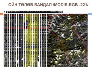
- 11. –Ю–Щ–Э –Ґ”®–Ы”®–Т –С–Р–Щ–Ф–Р–Ы /MODIS-RGB -221/ 1-—А 2-—А —Б–∞—А—Л–љ 4-—А —Б–∞—А—Л–љ—Б–∞—А—Л–љ—Б–∞—А—Л–љ 10282 —Б–∞—А—Л–љ 23 2-—А 2-—А 3-—А4-—А —Б–∞—А—Л–љ—Б–∞—А—Л–љ—Б–∞—А—Л–љ—Б–∞—А—Л–љ—Б–∞—А—Л–љ 18 —Б–∞—А—Л–љ 7 —Б–∞—А—Л–љ —Б–∞—А—Л–љ—Б–∞—А—Л–љ—Б–∞—А—Л–љ 12-—А 4 23 —Б–∞—А—Л–љ 6 15263 147-—А 8-—А 9-—А 11-—А —Б–∞—А—Л–љ 3-—А —Б–∞—А—Л–љ 5-—А 13274 8-—А 10-—А —Б–∞—А—Л–љ —Б–∞—А—Л–љ 5-—А 5-—А 8-—А 17247 312-—А
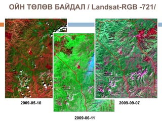
- 12. –Ю–Щ–Э –Ґ”®–Ы”®–Т –С–Р–Щ–Ф–Р–Ы / Landsat-RGB -721/ 2009-05-10 2009-09-07 2009-06-11
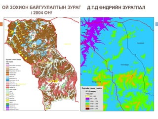
- 13. –Ю–Щ –Ч–Ю–•–Ш–Ю–Э –С–Р–Щ–У–£–£–Ы–Р–Ы–Ґ–Ђ–Э –Ч–£–†–Р–У –Ф.–Ґ.–Ф ”®–Э–Ф–†–Ш–Щ–Э –Ч–£–†–Р–У–Ы–Р–Ы / 2004 –Ю–Э/
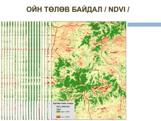
- 16. –Ю–Щ–Э –Ґ”®–Ы”®–Т –С–Р–Щ–Ф–Р–Ы / NDVI /
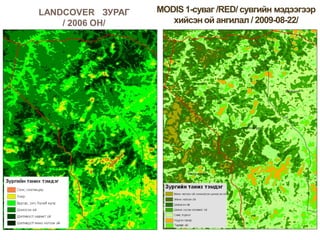
- 17. LANDCOVER –Ч–£–†–Р–У / 2006 –Ю–Э/
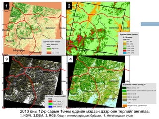
- 18. 1 2 3 4 2010 –Њ–љ—Л 12-—А —Б–∞—А—Л–љ 18-–љ—Л ”©–і—А–Є–є–љ –Љ—Н–і—Н—Н–љ –і—Н—Н—А –Њ–є–љ —В”©—А–ї–Є–є–≥ –∞–љ–≥–Є–ї–∞–≤. 1. NDVI, 2.DEM, 3. RGB /–±–Њ–і–Є—В ”©–љ–≥”©”©—А —Е–∞—А–∞–≥–і–∞—Е –±–∞–є–і–∞–ї, 4. –Р–љ–≥–Є–ї–∞–≥–і—Б–∞–љ –Ј—Г—А–∞–≥
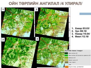
- 19. –Ю–Щ–Э –Ґ”®–†–Ы–Ш–Щ–Э –Р–Э–У–Ш–Ы–Р–Ы /4 –£–Ы–Ш–†–Р–Ы/ 1 3 1. –•–∞–≤–∞—А /03.03/ 2. –Ч—Г–љ /08.10/ 3. –Э–∞–Љ–∞—А /10.04/ 4. ”®–≤”©–ї /12.18/ 2 4
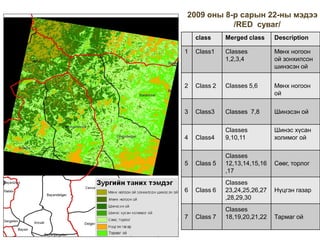
- 20. 2009 –Њ–љ—Л 8-—А —Б–∞—А—Л–љ 22-–љ—Л –Љ—Н–і—Н—Н /RED —Б—Г–≤–∞–≥/ class Merged class Description 1 Class1 Classes –Ь”©–љ—Е –љ–Њ–≥–Њ–Њ–љ 1,2,3,4 –Њ–є –Ј–Њ–љ—Е–Є–ї—Б–Њ–љ —И–Є–љ—Н—Б—Н–љ –Њ–є 2 Class 2 Classes 5,6 –Ь”©–љ—Е –љ–Њ–≥–Њ–Њ–љ –Њ–є 3 Class3 Classes 7,8 –®–Є–љ—Н—Б—Н–љ –Њ–є Classes –®–Є–љ—Н—Б —Е“ѓ—Б–∞–љ 4 Class4 9,10,11 —Е–Њ–ї–Є–Љ–Њ–≥ –Њ–є Classes 5 Class 5 12,13,14,15,16 –°”©”©–≥, —В–Њ—А–ї–Њ–≥ ,17 Classes 6 Class 6 23,24,25,26,27 –Э“ѓ—Ж–≥—Н–љ –≥–∞–Ј–∞—А ,28,29,30 Classes 7 Class 7 18,19,20,21,22 –Ґ–∞—А–Љ–∞–≥ –Њ–є
- 21. –Ф“Ѓ–У–Э–≠–Ы–Ґ пВ® MODIS вАУ—Л–љ —Б—Г–≤–≥–Є–є–љ –Љ—Н–і—Н—Н–≥—Н—Н—А –Њ–є–љ —В”©—А–ї–Є–є–≥ –∞–љ–≥–Є–ї–∞—Е –±–Њ–ї–Њ–Љ–ґ—В–Њ–є –±”©–≥”©”©–і 1-—А —Б—Г–≤–∞–≥ –±—Г—О—Г RED —Б—Г–≤–∞–≥ –љ—М –Є–ї“ѓ“ѓ –Є—Е –љ–Њ–≥–Њ–Њ–љ —Г—А–≥–∞–Љ–ї—Л–љ –Њ–є–ї—В—Л–≥ –Љ—Н–і—Н—А–і—Н–≥ –±–∞–є–љ–∞. пВ® –Ю–є–љ —В”©—А–ї–Є–є–љ –∞–љ–≥–Є–ї–∞–ї —Е–Є–є—Е–і—Н—Н –љ–Є–є—В 21 –Љ—Н–і—Н—Н–≥ —Г–ї–Є—А–ї—Л–љ —И–Є–љ–ґ —З–∞–љ–∞—А–∞–∞—А –љ—М —Е—Г–≤–∞–∞–ґ –∞–љ–≥–Є—Г–і—Л–љ —Е–Њ–Њ—А–Њ–љ–і—Л–љ —Е–∞–Љ–∞–∞—А–ї—Л–≥ —В–Њ–Њ—Ж–Њ–ґ, –≥–∞–Ј—А—Л–љ –Љ—Н–і—Н—Н—В—Н–є —Г—П–ї–і—Г—Г–ї–∞–љ –љ–Є–є—В 7 –∞–љ–≥–Є–і –±“ѓ–ї—Н–≥–ї—Н—Б—Н–љ. пВ® –Ю–є–љ —В”©—А”©–ї –љ—М –і.—В.–і ”©–љ–і—А”©”©—Б”©”© –±–Њ–ї–Њ–љ –Њ–є–љ —Г—А–≥–∞—Е –Њ—А—З–Є–љ–Њ–Њ—Б–Њ–Њ —Е–∞–Љ–∞–∞—А–і–∞–≥ –±–∞–є–љ–∞. пВ® –Ю–є –Ј–Њ—Е–Є–Њ–љ –±–∞–є–≥—Г—Г–ї–∞–ї—В—Л–љ –Љ—Н–і—Н—Н–≥ —Б—Г—Г—А—М –Љ—Н–і—Н—Н –±–Њ–ї–≥–Њ–љ –∞—И–Є–≥–ї–∞–≤. пВ® –¶–∞–∞—И–Є–і –≥–∞–Ј—А—Л–љ —Е—Н–Љ–ґ–Є–ї—В —Е–Є–є–ґ –∞–љ–≥–Є–ї–ї—Л–љ “ѓ—А –і“ѓ–љ–≥ —И–∞–ї–≥–∞—Е —И–∞–∞—А–і–ї–∞–≥–∞—В–∞–є.