際際滷

際際滷Share a Scribd company logo
Decision Support System for Infrastructure and Logistic
Management of Earthquake Situations
Mentor from SAP Innovation Center Turkey :
Onur Deniz
Instructor:
Prof.Dr. Ahmet CO?AR
Arctic Donkeys:
Zeynep Miray Mazlumo?lu
Arda Aslan
G?ksucan Ak?n
Onur Y?lmaz
CENG491 Computer Engineering Design
Fall Semester Presentation
Assistant:
It?r ?nal
Contents
? Motivation
? Project Definition
? Project Phases
- Data Gathering
- Data Modeling
- Visualization on GIS
? Challenges
? Future Plan
Motivation
?Seismic Zone
?Outdated and Low number of Similar Products
Retrieved from http://www.haber7.com/guncel/haber/904221-marmarayi-korkutan-deprem-uyarisi
Project Definition
-Risk Map According to Realistic + Synthetic Data Modeling
-Unit and Resource Distribution
-GIS Interface
-Recommendation to the User
-Targeted User Profile: Emergency Managers, Civil Administrators
-Pilot Area: Kad?k?y, ?stanbul
Project Phases
- Data Gathering:
* Age of Building
* Number of Floor in a Building
* Physical Condition of Buildings
* Total Number of Buildings in each District
* Ground Information
* Construction Material Information
Figure 1: Constructed Number of Buildings vs Ages
Figure 2: Constructed Number of Buildings vs Years
Project Phases
- Data Modeling:
- Attenuation Equation:
M: Magnitude
r: Horizontal distance
Vs: Shear-wave velocity
h: Fictitious depth
Va: Fictitious velocity
Y: Ground motion
Kalkan, E., & Gu?lkan, P. (2004). Attenuation Equation.
Figure 3: User Interface of System
Project Phases
- Visualization on GIS:
- What is GIS?
- Basemap Built-in Street Map of ArcGIS
Figure 4: Street Map of Kad?k?y
- Fetching Points from Excel File
- Special Coordinate System
-WGS_1984_Web_Mercator_Auxiliary_Sphere
- Z Value
- Interpolation according to Z Values
- Natural Neighbouring
Figure 5: Hot Spot Map of Kadikoy According to Random Z Values
Figure 6: Hot Spot Map of Kadikoy According to Calculated Z Values
14
Challenges
?Data gathering and creation
?Integration of System
?Modelling Algorithm
Future Plan
- Optimized Model
- Better Visualization
- Train the System
References
Kalkan, E., & Gu?lkan, P. (n.d.). Erratum: ^Site-Dependent Spectra Derived from Ground
Motion Records in Turkey ̄ [Earthquake Spectra 20, 1111C1138 (2004)]. Earthquake Spectra,
283-283.

More Related Content

Similar to Arctic donkeys-presentation (6)

PDF
Case Studies On Gis Fm Integration
John Przybyla
?
PDF
IRJET- Disaster Management System using Web
IRJET Journal
?
PDF
Disaster Resistance City- Denizli
Dr. Yilmaz Ozmen
?
PPT
9628432.ppt
SuharnoUsman1
?
PDF
Au 2007 It¨S Not Cad To Gis Final
Richard Chappell, GISP
?
PPTX
Istanbul Seismic Risk Mitigation and Emergency Preparedness Project (ISMEP)
Global Risk Forum GRFDavos
?
Case Studies On Gis Fm Integration
John Przybyla
?
IRJET- Disaster Management System using Web
IRJET Journal
?
Disaster Resistance City- Denizli
Dr. Yilmaz Ozmen
?
9628432.ppt
SuharnoUsman1
?
Au 2007 It¨S Not Cad To Gis Final
Richard Chappell, GISP
?
Istanbul Seismic Risk Mitigation and Emergency Preparedness Project (ISMEP)
Global Risk Forum GRFDavos
?

Recently uploaded (20)

PPTX
CST413 KTU S7 CSE Machine Learning Neural Networks and Support Vector Machine...
resming1
?
PPTX
WHO And BIS std- for water quality .pptx
dhanashree78
?
PPTX
Bharatiya Antariksh Hackathon 2025 Idea Submission PPT.pptx
AsadShad4
?
PPTX
Bitumen Emulsion by Dr Sangita Ex CRRI Delhi
grilcodes
?
PDF
????? ?? ??????? ?????????? ????? ?????? ??? ????.pdf
???? ??? ?????
?
PDF
Rapid Prototyping for XR: Lecture 5 - Cross Platform Development
Mark Billinghurst
?
PPTX
Mobile database systems 20254545645.pptx
herosh1968
?
PDF
Rapid Prototyping for XR: Lecture 3 - Video and Paper Prototyping
Mark Billinghurst
?
PPTX
Stability of IBR Dominated Grids - IEEE PEDG 2025 - short.pptx
ssuser307730
?
PPT
????? ???? ????? ??? ?? ???? ??? ???????
???? ??? ?????
?
PPTX
Kel.3_A_Review_on_Internet_of_Things_for_Defense_v3.pptx
Endang Saefullah
?
PPTX
Functions in Python Programming Language
BeulahS2
?
PPTX
How to Un-Obsolete Your Legacy Keypad Design
Epec Engineered Technologies
?
PDF
i氏Y創_Miipher and Miipher2 .
鰻粥京晦粥皆幄塀氏芙
?
PDF
CLIP_Internals_and_Architecture.pdf sdvsdv sdv
JoseLuisCahuanaRamos3
?
PPTX
Comparison of Flexible and Rigid Pavements in Bangladesh
Arifur Rahman
?
PPTX
LECTURE 7 COMPUTATIONS OF LEVELING DATA APRIL 2025.pptx
rr22001247
?
PPTX
CST413 KTU S7 CSE Machine Learning Clustering K Means Hierarchical Agglomerat...
resming1
?
PPTX
Introduction to Python Programming Language
merlinjohnsy
?
PDF
NFPA 10 - Estandar para extintores de incendios portatiles (ed.22 ENG).pdf
Oscar Orozco
?
CST413 KTU S7 CSE Machine Learning Neural Networks and Support Vector Machine...
resming1
?
WHO And BIS std- for water quality .pptx
dhanashree78
?
Bharatiya Antariksh Hackathon 2025 Idea Submission PPT.pptx
AsadShad4
?
Bitumen Emulsion by Dr Sangita Ex CRRI Delhi
grilcodes
?
????? ?? ??????? ?????????? ????? ?????? ??? ????.pdf
???? ??? ?????
?
Rapid Prototyping for XR: Lecture 5 - Cross Platform Development
Mark Billinghurst
?
Mobile database systems 20254545645.pptx
herosh1968
?
Rapid Prototyping for XR: Lecture 3 - Video and Paper Prototyping
Mark Billinghurst
?
Stability of IBR Dominated Grids - IEEE PEDG 2025 - short.pptx
ssuser307730
?
????? ???? ????? ??? ?? ???? ??? ???????
???? ??? ?????
?
Kel.3_A_Review_on_Internet_of_Things_for_Defense_v3.pptx
Endang Saefullah
?
Functions in Python Programming Language
BeulahS2
?
How to Un-Obsolete Your Legacy Keypad Design
Epec Engineered Technologies
?
i氏Y創_Miipher and Miipher2 .
鰻粥京晦粥皆幄塀氏芙
?
CLIP_Internals_and_Architecture.pdf sdvsdv sdv
JoseLuisCahuanaRamos3
?
Comparison of Flexible and Rigid Pavements in Bangladesh
Arifur Rahman
?
LECTURE 7 COMPUTATIONS OF LEVELING DATA APRIL 2025.pptx
rr22001247
?
CST413 KTU S7 CSE Machine Learning Clustering K Means Hierarchical Agglomerat...
resming1
?
Introduction to Python Programming Language
merlinjohnsy
?
NFPA 10 - Estandar para extintores de incendios portatiles (ed.22 ENG).pdf
Oscar Orozco
?
Ad

Arctic donkeys-presentation

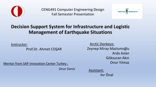
  • 1. Decision Support System for Infrastructure and Logistic Management of Earthquake Situations Mentor from SAP Innovation Center Turkey : Onur Deniz Instructor: Prof.Dr. Ahmet CO?AR Arctic Donkeys: Zeynep Miray Mazlumo?lu Arda Aslan G?ksucan Ak?n Onur Y?lmaz CENG491 Computer Engineering Design Fall Semester Presentation Assistant: It?r ?nal
  • 2. Contents ? Motivation ? Project Definition ? Project Phases - Data Gathering - Data Modeling - Visualization on GIS ? Challenges ? Future Plan
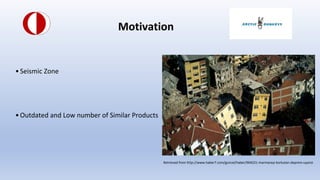
  • 3. Motivation ?Seismic Zone ?Outdated and Low number of Similar Products Retrieved from http://www.haber7.com/guncel/haber/904221-marmarayi-korkutan-deprem-uyarisi
  • 4. Project Definition -Risk Map According to Realistic + Synthetic Data Modeling -Unit and Resource Distribution -GIS Interface -Recommendation to the User -Targeted User Profile: Emergency Managers, Civil Administrators -Pilot Area: Kad?k?y, ?stanbul
  • 5. Project Phases - Data Gathering: * Age of Building * Number of Floor in a Building * Physical Condition of Buildings * Total Number of Buildings in each District * Ground Information * Construction Material Information
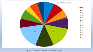
  • 6. Figure 1: Constructed Number of Buildings vs Ages
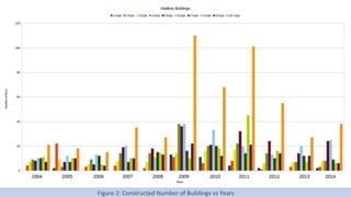
  • 7. Figure 2: Constructed Number of Buildings vs Years
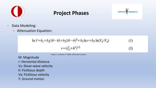
  • 8. Project Phases - Data Modeling: - Attenuation Equation: M: Magnitude r: Horizontal distance Vs: Shear-wave velocity h: Fictitious depth Va: Fictitious velocity Y: Ground motion Kalkan, E., & Gu?lkan, P. (2004). Attenuation Equation.
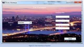
  • 9. Figure 3: User Interface of System
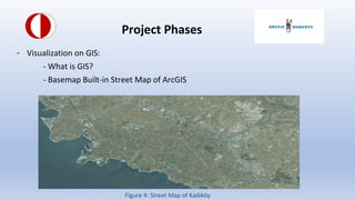
  • 10. Project Phases - Visualization on GIS: - What is GIS? - Basemap Built-in Street Map of ArcGIS Figure 4: Street Map of Kad?k?y
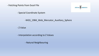
  • 11. - Fetching Points from Excel File - Special Coordinate System -WGS_1984_Web_Mercator_Auxiliary_Sphere - Z Value - Interpolation according to Z Values - Natural Neighbouring
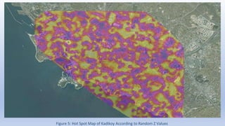
  • 12. Figure 5: Hot Spot Map of Kadikoy According to Random Z Values
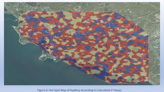
  • 13. Figure 6: Hot Spot Map of Kadikoy According to Calculated Z Values
  • 14. 14 Challenges ?Data gathering and creation ?Integration of System ?Modelling Algorithm
  • 15. Future Plan - Optimized Model - Better Visualization - Train the System
  • 16. References Kalkan, E., & Gu?lkan, P. (n.d.). Erratum: ^Site-Dependent Spectra Derived from Ground Motion Records in Turkey ̄ [Earthquake Spectra 20, 1111C1138 (2004)]. Earthquake Spectra, 283-283.