Don't Talk About It, Take Them There
5 likes593 views

The document discusses the features and uses of Google Earth, including placemarks, paths, polygons, models, image overlays, network links, and layers. It explains how these tools can be used to share locations and information or create virtual tours for educational purposes. Some examples given include applying live data, measuring distances, and scouting field trips.
1 of 44
Ad
Recommended
Aag
Aagdavidheyman
╠²
The document introduces Maker + Indiemapper, next generation mapping tools that allow users to easily create professional-looking thematic maps from GIS data with little to no training. Indiemapper utilizes the power of the web, allows for visual editing, and is packed with knowledge. It enables users to load shapefiles and KML, choose attributes and symbology, add basemaps and reference shapefiles, and create different types of thematic maps like choropleth, proportional symbols, and dot density maps. Indiemapper will be released in Summer 2009.Better Faster Cheaper - How Outside Developers Can Help Transit Agencies Info...
Better Faster Cheaper - How Outside Developers Can Help Transit Agencies Info...Joe Hughes
╠²
Joe Hughes aims to improve communication with riders and enhance internal information within transit agencies, which face budget constraints. He highlights the development of Google Transit and the creation of the Google Transit Feed Specification (GTFS) as solutions for collecting and sharing public transit data efficiently. The document emphasizes collaboration between agencies and developers to foster innovation and provide better tools for public transit.Large maps and WordPress
Large maps and WordPressDMWMartin
╠²
The Association of Scottish Community Councils (ASCC) aimed to create an interactive map for over 1,200 member councils on their WordPress site. Initial attempts using various WP plugins failed due to technical limitations, but leveraging BatchGeo allowed them to generate a functional map with latitude and longitude coordinates. However, the ASCC's impending closure resulted from a dispute with the Scottish government, raising concerns about the future of the map and the organization's online presence.Tnooz THack London - Travel Technology Europe showcase
Tnooz THack London - Travel Technology Europe showcaseKevin May
╠²
This document provides an overview of presentations given at a London hack day event. It describes several travel-related applications and APIs that were demonstrated, including:
- An application called "Worldreviewer" that provides travel inspiration and recommendations based on criteria like budget and interests.
- The Tripbod API, which was created to make it easier to build applications using Tripbod travel data by adding location awareness and filtering capabilities. Demo applications using this API were shown.
- An application called "Travoloon" that was demonstrated by EddMcArdle and Riaan van Schoor.
- The "geo.me" service from Stuart Grant, which utilizes various location data sources and APIs toWhat's The Fuss About Bing
What's The Fuss About BingCraig Bailey
╠²
This document provides an overview of Bing search capabilities presented by Mark Vozzo of Microsoft. It includes demos of augmented reality, paid search analytics, enhanced search previews using Wikipedia, visual search, travel search integrated with Foursquare, and map applications like World Cup venues and streetside photos. Requirements to run demos are Internet Explorer 8 and Silverlight 3. More information on Bing features can be found at discoverbing.com.We are Web 2.0 Girls Living in a Beta World
We are Web 2.0 Girls Living in a Beta Worldvwaskiewicz
╠²
The document provides a summary of various web 2.0 applications and services including ║▌║▌▀ŻShare, WiZiQ, iSpring, Vuvox, Gabcast, Timetoast, Text2Mindmap, ChartGizmo, Qrowd, Dabbleboard, GoAnimate, Poll Daddy, and VistaZoo. It describes what each application is used for and provides links to their websites. The directory was created in 2006 and had over 2700 logos as of September 2008.Tokyo April 2008 Openstreetmap
Tokyo April 2008 Openstreetmapchippy
╠²
OpenStreetMap is a collaborative project allowing users to create and edit a free map of the world, promoting the idea of public access to mapping data. The document discusses the importance of community involvement in data collection and mapping, citing influential figures like Tim Berners-Lee and Bill Gates. It emphasizes the potential of crowdsourced mapping to improve accuracy and detail, while also addressing various projects and future developments in the mapping industry.3 d internet
3 d internetSayanGhosh126
╠²
This document presents an overview of 3D internet, which combines 3D graphics with the internet. It discusses what 3D internet is, the reasons for its development like more interesting shopping and social interactions. The document then covers how 3D internet has evolved from earlier versions of the web, how it works using virtual platforms and sensors. Some advantages are its interactivity and content availability. Applications discussed include e-commerce, training, games and entertainment. Challenges to adoption include complexity, bandwidth limitations and lack of adoption by advertisers. The future potential of 3D internet is described as making web interactions easier and more effective within 10 years.╬£╬▒╬Ė╬▒╬»╬ĮŽē ╬ō╬ĄŽü╬╝╬▒╬Į╬╣╬║╬¼
╬£╬▒╬Ė╬▒╬»╬ĮŽē ╬ō╬ĄŽü╬╝╬▒╬Į╬╣╬║╬¼Dora Fassiani
╠²
╬¤╬┤╬Ę╬│ŽīŽé ╬Ģ╬║╬╝╬¼╬Ė╬ĘŽā╬ĘŽé ╬ō╬ĄŽü╬╝╬▒╬Į╬╣╬║ŽÄ╬ĮInteresting plant records 2014
Interesting plant records 2014Sussex Botanical Recording Society
╠²
This document summarizes interesting plant records found in 2014 in West Sussex (VC13) and East Sussex (VC14) including refinds of old records, plants found at new sites, and plants new to the counties. Some highlights mentioned are Green Hellebore found at a new site, Cut-grass at a new Sussex site, various poppy species found at new locations, and Yellow Dodder being a new record for Sussex. It thanks recorders for their efforts and notes that only a small selection of finds are included.Asp development enviorment install guide for mac os
Asp development enviorment install guide for mac osNamgee Lee
╠²
MacOS ĒÖśĻ▓ĮņŚÉņä£ Answer Set Programming Ļ░£ļ░£ ĒÖśĻ▓Į ĻĄ¼ņČĢ Ļ░ĆņØ┤ļō£.Shak Fight Reloadedshaktoons
╠²
El documento menciona 'Shak Fight Reloaded' y 'Shak Toons' como parte de un contenido disponible en www.freewebs.com. Se repite el enlace a 'Shak Toons'. No proporciona informaci├│n adicional o contexto relevante.╬£╬▒╬Ė╬▒╬»╬ĮŽē ╬Į╬▒ ╬║Žģ╬║╬╗╬┐Žå╬┐ŽüŽÄ ╬╝╬Ą Žä╬┐╬Į ╬ĀŽü╬▒Žā╬╣╬Į╬┐ŽŹ╬╗╬Ę ╬║╬▒╬╣ Žä╬Ę╬Į ╬Ü╬┐╬║╬║╬╣╬Į╬┐ŽŹ╬╗╬▒
╬£╬▒╬Ė╬▒╬»╬ĮŽē ╬Į╬▒ ╬║Žģ╬║╬╗╬┐Žå╬┐ŽüŽÄ ╬╝╬Ą Žä╬┐╬Į ╬ĀŽü╬▒Žā╬╣╬Į╬┐ŽŹ╬╗╬Ę ╬║╬▒╬╣ Žä╬Ę╬Į ╬Ü╬┐╬║╬║╬╣╬Į╬┐ŽŹ╬╗╬▒Dora Fassiani
╠²
╬ÜŽģ╬║╬╗╬┐Žå╬┐Žü╬╣╬▒╬║╬« ╬æ╬│Žē╬│╬«Cv augustinAugustin Gomis
╠²
Augustin Tenou Gomis est un citoyen s├®n├®galais, c├®libataire et sans enfant, n├® le 17 ao├╗t 1986 ├Ā Ziguinchor, S├®n├®gal. Il d├®tient une licence en g├®ographie ainsi que d'autres dipl├┤mes, dont un baccalaur├®at et un brevet de fin d'├®tudes moyennes, et a travaill├® comme moniteur en alphabetisation et animateur en sant├® de la reproduction des adolescents. Il parle couramment le fran├¦ais et l'anglais.Interesting plant records 2015
Interesting plant records 2015Sussex Botanical Recording Society
╠²
This document summarizes interesting plant records found in Sussex, England in 2015. Many rare and uncommon plants were discovered, including rediscoveries of old records, plants found in new locations, and species new to the area. A selection of these interesting finds are then listed, with details on the specific plant, location found, and significance of the record. The full list of interesting plant records for 2015 will be included in an upcoming newsletter.RSS is Changing The Web How Will It Change Our Classrooms
RSS is Changing The Web How Will It Change Our Classroomsqdsouza
╠²
The document discusses how RSS (Really Simple Syndication) can help teachers and students stay up-to-date with new online content and resources without having to spend hours searching the web. It explains what RSS is and how it allows users to automatically receive updated content from websites they subscribe to. The document also provides examples of how RSS and related tools can be used in classroom settings to merge and filter content, track collaboration, conduct searches, and more.Interesting plant records 2016
Interesting plant records 2016Sussex Botanical Recording Society
╠²
The document summarizes interesting plant records from 2016 in West Sussex (VC13) and East Sussex (VC14) as reported by recorders. It notes that over 15,000 records were received for VC13 and nearly 9,000 for VC14. Several new and rediscovered plant species are highlighted for each area, including hybrid eyebrights found in Steyning and Heyshott Down. The document also thanks all recorders for their excellent contributions again this year.Merrell In India
Merrell In IndiaDharmendra Gupta
╠²
Merrell launched its footwear brand in India through a three day outdoor event held in July 2008 near Mussorie, a hill station in Uttarakhand. Over 40 journalists, photographers and company representatives participated in outdoor activities like rappelling, treasure hunts and biking to showcase Merrell's performance shoes. The launch generated positive press coverage in numerous Indian publications. Merrell then promoted the brand through displays in retail stores across India and joint newspaper advertising campaigns with other footwear brands.Class 8b: Numpy & Matplotlib
Class 8b: Numpy & MatplotlibMarc Gouw
╠²
The document provides instructions for installing NumPy and Matplotlib on Ubuntu and includes examples of data creation, manipulation, and visualization using Python code. It covers creating one and two-dimensional arrays, performing basic mathematical operations, and generating plots for sine and cosine functions. Additionally, it demonstrates techniques for transforming and visualizing data, such as applying log transformations and displaying heatmaps.sole proprietorship and partnership
sole proprietorship and partnershipspookynuts
╠²
The document discusses different types of business organizations including sole proprietorship and partnership. Sole proprietorship refers to a business owned and controlled by an individual who receives all profits and bears all risks. A partnership is an agreement between two or more people to share profits of a business they carry on together. Key features of partnerships include equal risk bearing, joint decision making and continuity ensured through multiple members.online recharge services
online recharge servicesOPUS Infosoft
╠²
This presentation provides an overview of Opus Infosoft, an online services company established in 2012. It discusses Opus' business operations, including its services in prepaid recharges, bill payments, and DTH recharges through over 40,000 electronic terminals across 16 Indian states. The presentation also describes Opus' technical solutions and infrastructure, including its network architecture, application systems, access terminals, security measures, and e-recharge capabilities.Brochure procesos de cambio feb 2017marysacoach
╠²
La organizaci├│n Procesos de Cambio ofrece diversos programas dirigidos a expandir la conciencia, liberar el potencial humano, cambiar comportamientos, y mejorar la productividad y el clima laboral. Sus programas incluyen liderazgo de grandeza, vida con prop├│sito, esp├Łritu de equipo, pausas inspiracionales y expandiendo el cambio, todos los cuales buscan facilitar transformaciones positivas a nivel individual y organizacional.Dijimos que ......dannyelabandonado
╠²
El documento argumenta que la sociedad ha ido alej├Īndose de Dios al quitar la religi├│n de las escuelas y el gobierno. A medida que se han ido aceptando comportamientos como el aborto, la pornograf├Ła y la violencia en los medios, se ha perdido el sentido de lo que est├Ī bien y mal. Esto puede explicar por qu├® los j├│venes de hoy en d├Ła tienen problemas para distinguir entre el bien y el mal.ą▓čŗčüčłą░čÅ čłą║ąŠą╗ą░ ą╝ą░čĆą║ąĄčéąĖąĮą│ą░ ąĖ čĆą░ąĘą▓ąĖčéąĖčÅ ą▒ąĖąĘąĮąĄčüą░ ąĮąĖčā ą▓čłčŹ 02.02.2017
ą▓čŗčüčłą░čÅ čłą║ąŠą╗ą░ ą╝ą░čĆą║ąĄčéąĖąĮą│ą░ ąĖ čĆą░ąĘą▓ąĖčéąĖčÅ ą▒ąĖąĘąĮąĄčüą░ ąĮąĖčā ą▓čłčŹ 02.02.2017ąÆčŗčüčłą░čÅ čłą║ąŠą╗ą░ ą╝ą░čĆą║ąĄčéąĖąĮą│ą░ ąĖ čĆą░ąĘą▓ąĖčéąĖčÅ ą▒ąĖąĘąĮąĄčüą░ ąØąśąŻ ąÆą©ąŁ
╠²
ąÆčŗčüčłą░čÅ čłą║ąŠą╗ą░ ą╝ą░čĆą║ąĄčéąĖąĮą│ą░ ąĖ čĆą░ąĘą▓ąĖčéąĖčÅ ą▒ąĖąĘąĮąĄčüą░ ąØąśąŻ ąÆą©ąŁ ą┐čĆąŠą▓ąŠą┤ąĖčé ą┤ąĄąĮčī ąŠčéą║čĆčŗčéčŗčģ ą┤ą▓ąĄčĆąĄą╣ ą┤ą╗čÅ ąŠąĘąĮą░ą║ąŠą╝ą╗ąĄąĮąĖčÅ čü ąŠą▒čĆą░ąĘąŠą▓ą░č鹥ą╗čīąĮčŗą╝ąĖ ą┐čĆąŠą│čĆą░ą╝ą╝ą░ą╝ąĖ, čüąŠąĘą┤ą░ąĮąĮčŗą╝ąĖ ą┤ą╗čÅ ą┐ąŠą┤ą│ąŠč鹊ą▓ą║ąĖ čüą┐ąĄčåąĖą░ą╗ąĖčüč鹊ą▓ ą▓ ąŠą▒ą╗ą░čüčéąĖ ą╝ą░čĆą║ąĄčéąĖąĮą│ą░. ą©ą║ąŠą╗ą░ ą┐čĆąĄą┤ą╗ą░ą│ą░ąĄčé čĆą░ąĘąĮąŠąŠą▒čĆą░ąĘąĮčŗąĄ ą║čāčĆčüčŗ, ą▓ą║ą╗čÄčćą░čÅ čüąĄčĆčéąĖčäąĖą║ą░čåąĖąŠąĮąĮčŗąĄ ą┐čĆąŠą│čĆą░ą╝ą╝čŗ ąĖ čüą┐ąĄčåąĖą░ą╗ąĖąĘą░čåąĖąĖ, ą░ą║čåąĄąĮčéąĖčĆčāčÅ ą▓ąĮąĖą╝ą░ąĮąĖąĄ ąĮą░ ą┐čĆą░ą║čéąĖč湥čüą║ąŠą╝ ą┐čĆąĖą╝ąĄąĮąĄąĮąĖąĖ ąĘąĮą░ąĮąĖą╣ ąĖ ąĖąĮąĮąŠą▓ą░čåąĖąŠąĮąĮčŗčģ ą┐ąŠą┤čģąŠą┤ą░čģ ą▓ čāą┐čĆą░ą▓ą╗ąĄąĮąĖąĖ ą╝ą░čĆą║ąĄčéąĖąĮą│ąŠą╝. ą×ąĮą░ čéą░ą║ąČąĄ čÅą▓ą╗čÅąĄčéčüčÅ čćą╗ąĄąĮąŠą╝ ąĢą▓čĆąŠą┐ąĄą╣čüą║ąŠą╣ ą╝ą░čĆą║ąĄčéąĖąĮą│ąŠą▓ąŠą╣ ą║ąŠąĮč乥ą┤ąĄčĆą░čåąĖąĖ ąĖ ą┐čĆąĄą┤ąŠčüčéą░ą▓ą╗čÅąĄčé čāąĮąĖą║ą░ą╗čīąĮčŗąĄ ą▓ąŠąĘą╝ąŠąČąĮąŠčüčéąĖ ą┤ą╗čÅ ą║ą░čĆčīąĄčĆąĮąŠą│ąŠ čĆąŠčüčéą░ ą▓čŗą┐čāčüą║ąĮąĖą║ąŠą▓.ą║čĆčāąĖąĘ ąĮą░ ą╗ąĄą┤ąŠą║ąŠą╗ąĄ3
ą║čĆčāąĖąĘ ąĮą░ ą╗ąĄą┤ąŠą║ąŠą╗ąĄ3ąØą░ą┤ąĄąČą┤ą░ ąĪčéą░čģąĄąĄą▓ą░
╠²
ąöąŠą║čāą╝ąĄąĮčé ą┐ąŠčüą▓čÅčēąĄąĮ ą┤ąĖą║ąŠą╣ ą┐čĆąĖčĆąŠą┤ąĄ ąĀąŠčüčüąĖąĖ, ąŠčüąŠą▒ąĄąĮąĮčŗą╝ ąŠą▒čĆą░ąĘąŠą╝ ą░ą║čåąĄąĮčéąĖčĆčāčÅ ą▓ąĮąĖą╝ą░ąĮąĖąĄ ąĮą░ ą░čĆą║čéąĖč湥čüą║ąĖčģ čĆąĄą│ąĖąŠąĮą░čģ, čéą░ą║ąĖčģ ą║ą░ą║ ąĮą░čåąĖąŠąĮą░ą╗čīąĮčŗą╣ ą┐ą░čĆą║ 'ąĀčāčüčüą║ą░čÅ ąÉčĆą║čéąĖą║ą░' ąĖ ąóą░ą╣ą╝čŗčĆčüą║ąĖą╣ ąĘą░ą┐ąŠą▓ąĄą┤ąĮąĖą║. ą×ąĮ ąŠą┐ąĖčüčŗą▓ą░ąĄčé čāąĮąĖą║ą░ą╗čīąĮčŗąĄ 菹║ąŠčüąĖčüč鹥ą╝čŗ, ąŠą▒ąĖčéą░ąĮąĖąĄ čĆąĄą┤ą║ąĖčģ ą▓ąĖą┤ąŠą▓ ąČąĖą▓ąŠčéąĮčŗčģ ąĖ ą┐čĆąĖčĆąŠą┤ąĮčŗąĄ čÅą▓ą╗ąĄąĮąĖčÅ, čéą░ą║ąĖąĄ ą║ą░ą║ ą┐ąŠą╗čÅčĆąĮąŠąĄ čüąĖčÅąĮąĖąĄ, ą░ čéą░ą║ąČąĄ ą▓ąŠąĘą╝ąŠąČąĮąŠčüčéąĖ ą┤ą╗čÅ čéčāčĆąĖąĘą╝ą░ ąĖ ąĖčüčüą╗ąĄą┤ąŠą▓ą░ąĮąĖčÅ. ą×čüąŠą▒ąŠąĄ ą▓ąĮąĖą╝ą░ąĮąĖąĄ čāą┤ąĄą╗čÅąĄčéčüčÅ ąŠčģčĆą░ąĮąĄ ą┐čĆąĖčĆąŠą┤čŗ ąĖ ą┐čĆąŠą▓ąĄą┤ąĄąĮąĖčÄ ą║čāą╗čīčéčāčĆąĮčŗčģ čüąŠą▒čŗčéąĖą╣, čüą▓čÅąĘą░ąĮąĮčŗčģ čü čéčĆą░ą┤ąĖčåąĖąŠąĮąĮčŗą╝ ąŠą▒čĆą░ąĘąŠą╝ ąČąĖąĘąĮąĖ ą║ąŠčĆąĄąĮąĮčŗčģ ąĮą░čĆąŠą┤ąŠą▓.Innovation Opportunity_PGS
Innovation Opportunity_PGSAdam Thorsfeldt
╠²
This document outlines the benefits of using the company's unique pristine graphene composite. It notes it achieves a high conversion rate from graphite without using oxides, and matches a reference sample. The graphene composite can be easily dispersed without clumping into many materials. It is hydrophobic in oils and allows for hazardous materials remediation. The composite acts as a scaffold between graphene sheets, binding readily with other materials. It contains no pinholes or oxides, and offers graphene flakes at a low cost for industrial applications.Google earth in the classroom
Google earth in the classroomKenneth Endfinger
╠²
Google Earth allows users to explore locations on Earth and in space. It can be used in the classroom to create interactive projects with images, text, video and sound. Teachers can add placemarks to locations, and attach files like images and videos. Students can design storyboards and keep all project materials organized in folders before adding them to locations in Google Earth.Petec Google Earth
Petec Google Earthdamopsu
╠²
This document provides an overview of how to use Google Earth in the classroom. It discusses features like search, places, layers, adding placemarks, polygons, paths, images, videos and links. Specific examples are given, such as creating a web crawl of the American Revolution and adding a floating object screen overlay. Resources for lesson plans using Google Earth are also listed.More Related Content
Viewers also liked (20)
╬£╬▒╬Ė╬▒╬»╬ĮŽē ╬ō╬ĄŽü╬╝╬▒╬Į╬╣╬║╬¼
╬£╬▒╬Ė╬▒╬»╬ĮŽē ╬ō╬ĄŽü╬╝╬▒╬Į╬╣╬║╬¼Dora Fassiani
╠²
╬¤╬┤╬Ę╬│ŽīŽé ╬Ģ╬║╬╝╬¼╬Ė╬ĘŽā╬ĘŽé ╬ō╬ĄŽü╬╝╬▒╬Į╬╣╬║ŽÄ╬ĮInteresting plant records 2014
Interesting plant records 2014Sussex Botanical Recording Society
╠²
This document summarizes interesting plant records found in 2014 in West Sussex (VC13) and East Sussex (VC14) including refinds of old records, plants found at new sites, and plants new to the counties. Some highlights mentioned are Green Hellebore found at a new site, Cut-grass at a new Sussex site, various poppy species found at new locations, and Yellow Dodder being a new record for Sussex. It thanks recorders for their efforts and notes that only a small selection of finds are included.Asp development enviorment install guide for mac os
Asp development enviorment install guide for mac osNamgee Lee
╠²
MacOS ĒÖśĻ▓ĮņŚÉņä£ Answer Set Programming Ļ░£ļ░£ ĒÖśĻ▓Į ĻĄ¼ņČĢ Ļ░ĆņØ┤ļō£.Shak Fight Reloadedshaktoons
╠²
El documento menciona 'Shak Fight Reloaded' y 'Shak Toons' como parte de un contenido disponible en www.freewebs.com. Se repite el enlace a 'Shak Toons'. No proporciona informaci├│n adicional o contexto relevante.╬£╬▒╬Ė╬▒╬»╬ĮŽē ╬Į╬▒ ╬║Žģ╬║╬╗╬┐Žå╬┐ŽüŽÄ ╬╝╬Ą Žä╬┐╬Į ╬ĀŽü╬▒Žā╬╣╬Į╬┐ŽŹ╬╗╬Ę ╬║╬▒╬╣ Žä╬Ę╬Į ╬Ü╬┐╬║╬║╬╣╬Į╬┐ŽŹ╬╗╬▒
╬£╬▒╬Ė╬▒╬»╬ĮŽē ╬Į╬▒ ╬║Žģ╬║╬╗╬┐Žå╬┐ŽüŽÄ ╬╝╬Ą Žä╬┐╬Į ╬ĀŽü╬▒Žā╬╣╬Į╬┐ŽŹ╬╗╬Ę ╬║╬▒╬╣ Žä╬Ę╬Į ╬Ü╬┐╬║╬║╬╣╬Į╬┐ŽŹ╬╗╬▒Dora Fassiani
╠²
╬ÜŽģ╬║╬╗╬┐Žå╬┐Žü╬╣╬▒╬║╬« ╬æ╬│Žē╬│╬«Cv augustinAugustin Gomis
╠²
Augustin Tenou Gomis est un citoyen s├®n├®galais, c├®libataire et sans enfant, n├® le 17 ao├╗t 1986 ├Ā Ziguinchor, S├®n├®gal. Il d├®tient une licence en g├®ographie ainsi que d'autres dipl├┤mes, dont un baccalaur├®at et un brevet de fin d'├®tudes moyennes, et a travaill├® comme moniteur en alphabetisation et animateur en sant├® de la reproduction des adolescents. Il parle couramment le fran├¦ais et l'anglais.Interesting plant records 2015
Interesting plant records 2015Sussex Botanical Recording Society
╠²
This document summarizes interesting plant records found in Sussex, England in 2015. Many rare and uncommon plants were discovered, including rediscoveries of old records, plants found in new locations, and species new to the area. A selection of these interesting finds are then listed, with details on the specific plant, location found, and significance of the record. The full list of interesting plant records for 2015 will be included in an upcoming newsletter.RSS is Changing The Web How Will It Change Our Classrooms
RSS is Changing The Web How Will It Change Our Classroomsqdsouza
╠²
The document discusses how RSS (Really Simple Syndication) can help teachers and students stay up-to-date with new online content and resources without having to spend hours searching the web. It explains what RSS is and how it allows users to automatically receive updated content from websites they subscribe to. The document also provides examples of how RSS and related tools can be used in classroom settings to merge and filter content, track collaboration, conduct searches, and more.Interesting plant records 2016
Interesting plant records 2016Sussex Botanical Recording Society
╠²
The document summarizes interesting plant records from 2016 in West Sussex (VC13) and East Sussex (VC14) as reported by recorders. It notes that over 15,000 records were received for VC13 and nearly 9,000 for VC14. Several new and rediscovered plant species are highlighted for each area, including hybrid eyebrights found in Steyning and Heyshott Down. The document also thanks all recorders for their excellent contributions again this year.Merrell In India
Merrell In IndiaDharmendra Gupta
╠²
Merrell launched its footwear brand in India through a three day outdoor event held in July 2008 near Mussorie, a hill station in Uttarakhand. Over 40 journalists, photographers and company representatives participated in outdoor activities like rappelling, treasure hunts and biking to showcase Merrell's performance shoes. The launch generated positive press coverage in numerous Indian publications. Merrell then promoted the brand through displays in retail stores across India and joint newspaper advertising campaigns with other footwear brands.Class 8b: Numpy & Matplotlib
Class 8b: Numpy & MatplotlibMarc Gouw
╠²
The document provides instructions for installing NumPy and Matplotlib on Ubuntu and includes examples of data creation, manipulation, and visualization using Python code. It covers creating one and two-dimensional arrays, performing basic mathematical operations, and generating plots for sine and cosine functions. Additionally, it demonstrates techniques for transforming and visualizing data, such as applying log transformations and displaying heatmaps.sole proprietorship and partnership
sole proprietorship and partnershipspookynuts
╠²
The document discusses different types of business organizations including sole proprietorship and partnership. Sole proprietorship refers to a business owned and controlled by an individual who receives all profits and bears all risks. A partnership is an agreement between two or more people to share profits of a business they carry on together. Key features of partnerships include equal risk bearing, joint decision making and continuity ensured through multiple members.online recharge services
online recharge servicesOPUS Infosoft
╠²
This presentation provides an overview of Opus Infosoft, an online services company established in 2012. It discusses Opus' business operations, including its services in prepaid recharges, bill payments, and DTH recharges through over 40,000 electronic terminals across 16 Indian states. The presentation also describes Opus' technical solutions and infrastructure, including its network architecture, application systems, access terminals, security measures, and e-recharge capabilities.Brochure procesos de cambio feb 2017marysacoach
╠²
La organizaci├│n Procesos de Cambio ofrece diversos programas dirigidos a expandir la conciencia, liberar el potencial humano, cambiar comportamientos, y mejorar la productividad y el clima laboral. Sus programas incluyen liderazgo de grandeza, vida con prop├│sito, esp├Łritu de equipo, pausas inspiracionales y expandiendo el cambio, todos los cuales buscan facilitar transformaciones positivas a nivel individual y organizacional.Dijimos que ......dannyelabandonado
╠²
El documento argumenta que la sociedad ha ido alej├Īndose de Dios al quitar la religi├│n de las escuelas y el gobierno. A medida que se han ido aceptando comportamientos como el aborto, la pornograf├Ła y la violencia en los medios, se ha perdido el sentido de lo que est├Ī bien y mal. Esto puede explicar por qu├® los j├│venes de hoy en d├Ła tienen problemas para distinguir entre el bien y el mal.ą▓čŗčüčłą░čÅ čłą║ąŠą╗ą░ ą╝ą░čĆą║ąĄčéąĖąĮą│ą░ ąĖ čĆą░ąĘą▓ąĖčéąĖčÅ ą▒ąĖąĘąĮąĄčüą░ ąĮąĖčā ą▓čłčŹ 02.02.2017
ą▓čŗčüčłą░čÅ čłą║ąŠą╗ą░ ą╝ą░čĆą║ąĄčéąĖąĮą│ą░ ąĖ čĆą░ąĘą▓ąĖčéąĖčÅ ą▒ąĖąĘąĮąĄčüą░ ąĮąĖčā ą▓čłčŹ 02.02.2017ąÆčŗčüčłą░čÅ čłą║ąŠą╗ą░ ą╝ą░čĆą║ąĄčéąĖąĮą│ą░ ąĖ čĆą░ąĘą▓ąĖčéąĖčÅ ą▒ąĖąĘąĮąĄčüą░ ąØąśąŻ ąÆą©ąŁ
╠²
ąÆčŗčüčłą░čÅ čłą║ąŠą╗ą░ ą╝ą░čĆą║ąĄčéąĖąĮą│ą░ ąĖ čĆą░ąĘą▓ąĖčéąĖčÅ ą▒ąĖąĘąĮąĄčüą░ ąØąśąŻ ąÆą©ąŁ ą┐čĆąŠą▓ąŠą┤ąĖčé ą┤ąĄąĮčī ąŠčéą║čĆčŗčéčŗčģ ą┤ą▓ąĄčĆąĄą╣ ą┤ą╗čÅ ąŠąĘąĮą░ą║ąŠą╝ą╗ąĄąĮąĖčÅ čü ąŠą▒čĆą░ąĘąŠą▓ą░č鹥ą╗čīąĮčŗą╝ąĖ ą┐čĆąŠą│čĆą░ą╝ą╝ą░ą╝ąĖ, čüąŠąĘą┤ą░ąĮąĮčŗą╝ąĖ ą┤ą╗čÅ ą┐ąŠą┤ą│ąŠč鹊ą▓ą║ąĖ čüą┐ąĄčåąĖą░ą╗ąĖčüč鹊ą▓ ą▓ ąŠą▒ą╗ą░čüčéąĖ ą╝ą░čĆą║ąĄčéąĖąĮą│ą░. ą©ą║ąŠą╗ą░ ą┐čĆąĄą┤ą╗ą░ą│ą░ąĄčé čĆą░ąĘąĮąŠąŠą▒čĆą░ąĘąĮčŗąĄ ą║čāčĆčüčŗ, ą▓ą║ą╗čÄčćą░čÅ čüąĄčĆčéąĖčäąĖą║ą░čåąĖąŠąĮąĮčŗąĄ ą┐čĆąŠą│čĆą░ą╝ą╝čŗ ąĖ čüą┐ąĄčåąĖą░ą╗ąĖąĘą░čåąĖąĖ, ą░ą║čåąĄąĮčéąĖčĆčāčÅ ą▓ąĮąĖą╝ą░ąĮąĖąĄ ąĮą░ ą┐čĆą░ą║čéąĖč湥čüą║ąŠą╝ ą┐čĆąĖą╝ąĄąĮąĄąĮąĖąĖ ąĘąĮą░ąĮąĖą╣ ąĖ ąĖąĮąĮąŠą▓ą░čåąĖąŠąĮąĮčŗčģ ą┐ąŠą┤čģąŠą┤ą░čģ ą▓ čāą┐čĆą░ą▓ą╗ąĄąĮąĖąĖ ą╝ą░čĆą║ąĄčéąĖąĮą│ąŠą╝. ą×ąĮą░ čéą░ą║ąČąĄ čÅą▓ą╗čÅąĄčéčüčÅ čćą╗ąĄąĮąŠą╝ ąĢą▓čĆąŠą┐ąĄą╣čüą║ąŠą╣ ą╝ą░čĆą║ąĄčéąĖąĮą│ąŠą▓ąŠą╣ ą║ąŠąĮč乥ą┤ąĄčĆą░čåąĖąĖ ąĖ ą┐čĆąĄą┤ąŠčüčéą░ą▓ą╗čÅąĄčé čāąĮąĖą║ą░ą╗čīąĮčŗąĄ ą▓ąŠąĘą╝ąŠąČąĮąŠčüčéąĖ ą┤ą╗čÅ ą║ą░čĆčīąĄčĆąĮąŠą│ąŠ čĆąŠčüčéą░ ą▓čŗą┐čāčüą║ąĮąĖą║ąŠą▓.ą║čĆčāąĖąĘ ąĮą░ ą╗ąĄą┤ąŠą║ąŠą╗ąĄ3
ą║čĆčāąĖąĘ ąĮą░ ą╗ąĄą┤ąŠą║ąŠą╗ąĄ3ąØą░ą┤ąĄąČą┤ą░ ąĪčéą░čģąĄąĄą▓ą░
╠²
ąöąŠą║čāą╝ąĄąĮčé ą┐ąŠčüą▓čÅčēąĄąĮ ą┤ąĖą║ąŠą╣ ą┐čĆąĖčĆąŠą┤ąĄ ąĀąŠčüčüąĖąĖ, ąŠčüąŠą▒ąĄąĮąĮčŗą╝ ąŠą▒čĆą░ąĘąŠą╝ ą░ą║čåąĄąĮčéąĖčĆčāčÅ ą▓ąĮąĖą╝ą░ąĮąĖąĄ ąĮą░ ą░čĆą║čéąĖč湥čüą║ąĖčģ čĆąĄą│ąĖąŠąĮą░čģ, čéą░ą║ąĖčģ ą║ą░ą║ ąĮą░čåąĖąŠąĮą░ą╗čīąĮčŗą╣ ą┐ą░čĆą║ 'ąĀčāčüčüą║ą░čÅ ąÉčĆą║čéąĖą║ą░' ąĖ ąóą░ą╣ą╝čŗčĆčüą║ąĖą╣ ąĘą░ą┐ąŠą▓ąĄą┤ąĮąĖą║. ą×ąĮ ąŠą┐ąĖčüčŗą▓ą░ąĄčé čāąĮąĖą║ą░ą╗čīąĮčŗąĄ 菹║ąŠčüąĖčüč鹥ą╝čŗ, ąŠą▒ąĖčéą░ąĮąĖąĄ čĆąĄą┤ą║ąĖčģ ą▓ąĖą┤ąŠą▓ ąČąĖą▓ąŠčéąĮčŗčģ ąĖ ą┐čĆąĖčĆąŠą┤ąĮčŗąĄ čÅą▓ą╗ąĄąĮąĖčÅ, čéą░ą║ąĖąĄ ą║ą░ą║ ą┐ąŠą╗čÅčĆąĮąŠąĄ čüąĖčÅąĮąĖąĄ, ą░ čéą░ą║ąČąĄ ą▓ąŠąĘą╝ąŠąČąĮąŠčüčéąĖ ą┤ą╗čÅ čéčāčĆąĖąĘą╝ą░ ąĖ ąĖčüčüą╗ąĄą┤ąŠą▓ą░ąĮąĖčÅ. ą×čüąŠą▒ąŠąĄ ą▓ąĮąĖą╝ą░ąĮąĖąĄ čāą┤ąĄą╗čÅąĄčéčüčÅ ąŠčģčĆą░ąĮąĄ ą┐čĆąĖčĆąŠą┤čŗ ąĖ ą┐čĆąŠą▓ąĄą┤ąĄąĮąĖčÄ ą║čāą╗čīčéčāčĆąĮčŗčģ čüąŠą▒čŗčéąĖą╣, čüą▓čÅąĘą░ąĮąĮčŗčģ čü čéčĆą░ą┤ąĖčåąĖąŠąĮąĮčŗą╝ ąŠą▒čĆą░ąĘąŠą╝ ąČąĖąĘąĮąĖ ą║ąŠčĆąĄąĮąĮčŗčģ ąĮą░čĆąŠą┤ąŠą▓.Innovation Opportunity_PGS
Innovation Opportunity_PGSAdam Thorsfeldt
╠²
This document outlines the benefits of using the company's unique pristine graphene composite. It notes it achieves a high conversion rate from graphite without using oxides, and matches a reference sample. The graphene composite can be easily dispersed without clumping into many materials. It is hydrophobic in oils and allows for hazardous materials remediation. The composite acts as a scaffold between graphene sheets, binding readily with other materials. It contains no pinholes or oxides, and offers graphene flakes at a low cost for industrial applications.╬£╬▒╬Ė╬▒╬»╬ĮŽē ╬Į╬▒ ╬║Žģ╬║╬╗╬┐Žå╬┐ŽüŽÄ ╬╝╬Ą Žä╬┐╬Į ╬ĀŽü╬▒Žā╬╣╬Į╬┐ŽŹ╬╗╬Ę ╬║╬▒╬╣ Žä╬Ę╬Į ╬Ü╬┐╬║╬║╬╣╬Į╬┐ŽŹ╬╗╬▒
╬£╬▒╬Ė╬▒╬»╬ĮŽē ╬Į╬▒ ╬║Žģ╬║╬╗╬┐Žå╬┐ŽüŽÄ ╬╝╬Ą Žä╬┐╬Į ╬ĀŽü╬▒Žā╬╣╬Į╬┐ŽŹ╬╗╬Ę ╬║╬▒╬╣ Žä╬Ę╬Į ╬Ü╬┐╬║╬║╬╣╬Į╬┐ŽŹ╬╗╬▒Dora Fassiani
╠²
ą▓čŗčüčłą░čÅ čłą║ąŠą╗ą░ ą╝ą░čĆą║ąĄčéąĖąĮą│ą░ ąĖ čĆą░ąĘą▓ąĖčéąĖčÅ ą▒ąĖąĘąĮąĄčüą░ ąĮąĖčā ą▓čłčŹ 02.02.2017
ą▓čŗčüčłą░čÅ čłą║ąŠą╗ą░ ą╝ą░čĆą║ąĄčéąĖąĮą│ą░ ąĖ čĆą░ąĘą▓ąĖčéąĖčÅ ą▒ąĖąĘąĮąĄčüą░ ąĮąĖčā ą▓čłčŹ 02.02.2017ąÆčŗčüčłą░čÅ čłą║ąŠą╗ą░ ą╝ą░čĆą║ąĄčéąĖąĮą│ą░ ąĖ čĆą░ąĘą▓ąĖčéąĖčÅ ą▒ąĖąĘąĮąĄčüą░ ąØąśąŻ ąÆą©ąŁ
╠²
Similar to Don't Talk About It, Take Them There (20)
Google earth in the classroom
Google earth in the classroomKenneth Endfinger
╠²
Google Earth allows users to explore locations on Earth and in space. It can be used in the classroom to create interactive projects with images, text, video and sound. Teachers can add placemarks to locations, and attach files like images and videos. Students can design storyboards and keep all project materials organized in folders before adding them to locations in Google Earth.Petec Google Earth
Petec Google Earthdamopsu
╠²
This document provides an overview of how to use Google Earth in the classroom. It discusses features like search, places, layers, adding placemarks, polygons, paths, images, videos and links. Specific examples are given, such as creating a web crawl of the American Revolution and adding a floating object screen overlay. Resources for lesson plans using Google Earth are also listed.Guide to Google Earth
Guide to Google EarthDodge City Public Schools
╠²
Google Earth is a virtual globe program that integrates satellite imagery, maps, and search capabilities to provide users with geographic information. It offers various features like path drawing, measuring distances, and creating project folders with placemarks that can include multimedia content for educational purposes. Users can also explore additional features like Google Sky to observe astronomical objects, enhancing the overall interactive experience.Google Earth Basics
Google Earth BasicsDesiree Caskey
╠²
Google Earth is a program that allows users to view satellite imagery and maps of Earth. It has various navigation and search tools to explore locations. Users can add placemarks, paths, images and create tours to save and organize places. Google Earth also has layers that can be turned on and off to view additional data like roads, traffic, weather and Wikipedia information. Users can create folders to store searches and tours they create. Google Earth uses .kmz and .kml files to save placemarks, tours and other location information created by users.A Round Trip Ticket to Google Earth and Sky
A Round Trip Ticket to Google Earth and SkyDodge City Public Schools
╠²
Google Earth is a virtual globe program that integrates satellite imagery, maps, and Google search for geographic exploration. The latest version offers features such as improved 3D models, navigation tools, and the ability to create custom tours with multimedia content. Users can measure distances, overlay images, and save their projects in .kmz format for sharing.Google earth
Google earthdamopsu
╠²
Google Earth is a mapping tool that allows users to view satellite imagery and 3D models of locations around the world. It has many features that can be used in the classroom, such as layers that integrate additional data, distance measurement tools, and the ability to embed videos, images and websites in user-created placemarks and tours. Examples provided demonstrate how students have used Google Earth for virtual field trips to study frogs on different continents and to collaboratively report on climate and weather from regions around the world. The document provides guidance on how to incorporate tools like placemarks, polygons and overlays into lessons to engage students and help them conceptualize geographic concepts.How to Use Google Earth
How to Use Google EarthHammarskjold Middle School
╠²
This presentation introduces Google Earth and its capabilities for classroom use. Google Earth allows users to search locations, place placemarks and paths, add layers of additional information, and take or create virtual tours. It provides tools to help teachers bring geography to life and support lessons across subjects. The presenter provides examples of easy, intermediate, and advanced lesson plans and activities that can be created with Google Earth.Google Earth Social Studies
Google Earth Social Studiesdamopsu
╠²
This document provides an overview of Google Earth and ways it can be used in the classroom. It discusses features of Google Earth like layers, distance measurements, linking additional content, and creating paths and tours. Examples are given of how Google Earth has been used to teach about the American Revolution, climate, and frogs. Directions are provided for adding placemarks, images, videos and creating screen overlays. Resources for lesson plans and help with Google Earth are also listed.Google Earth Social Studies
Google Earth Social Studiesdamopsu
╠²
This document provides an overview of Google Earth and suggestions for how to use it in the classroom. It discusses what Google Earth is, its features like layers and tools, and examples of lessons on topics like the American Revolution, climate, and frogs that incorporate Google Earth. It also demonstrates how to add placemarks, images, videos and create tours using Google Earth for educational projects.Google Earth for Beginners
Google Earth for BeginnersErica Roberts
╠²
Ms. Roberts
School: Jefferson Junior High
City, State: Woodridge, ILGoogle Earth overview
Google Earth overviewSophie Lagac├®, P.E.
╠²
The document is a comprehensive guide on using Google Earth, detailing how to find locations, navigate the interface, and create and organize layers. It includes instructions on inserting various elements like placemarks, polygons, and aerial photos, along with tips on measuring distances and importing external maps. Additional resources and help sites are provided for users seeking further assistance or information.Google Earth
Google EarthLaura Wilson
╠²
Laura Wilson, a reference librarian, presented on using the free software Google Earth for educational purposes. Google Earth allows users to virtually explore terrain, buildings, places of interest, and photos/videos from locations around the world. Teachers have used Google Earth across many disciplines by having students independently explore locations or through tours with embedded images and audio. Google Earth provides opportunities for curiosity, exploration, and discovery beyond typical lessons.Google Earth Basics
Google Earth Basicsteedawg12
╠²
Google Earth is a free program that allows users to view Earth from space. It contains satellite imagery, maps, and tools to create placemarks and measure distances. This document provides an overview of how to get started with Google Earth, navigate around the globe, search for locations, add placemarks, and use layers and additional features. It also lists some educational resources for using Google Earth in the classroom.Virtutal Field Trip with Google Earth
Virtutal Field Trip with Google Earthsmclendon
╠²
The document provides instructions for how to add various types of multimedia content to placemarks in Google Earth, including links, images, and videos. It describes how to edit placemark properties to insert things like hyperlinks with descriptive text, embed images by pasting their URL into the description, and include YouTube videos by copying the embed code and pasting it into the placemark properties. Proper formatting is emphasized to make the embedded content appear neatly within the placemark pop-up window.Engage With Google Earth
Engage With Google EarthHoover City Schools
╠²
This document provides an overview of ways to use Google Earth in the classroom across different subject areas including social studies, language arts, math, and geography. It discusses examples of historical tours, placemarks from novels, measuring distance, latitude and longitude, and more. It also provides resources for creating tours in Google Earth, integrating multimedia like videos and images, and finding lesson ideas and tutorials.Google mapping in the newsroom part 2
Google mapping in the newsroom part 2Esther Vargas
╠²
The document discusses various mapping tools from Google that can be used in journalism, including Google Maps, Google Earth, and Street View. Google Maps is a web-based 2D map that can be used to search locations, get directions, and add additional data layers. Google Earth is a downloadable 3D application that allows users to view satellite imagery and terrain of locations. Both tools allow embedding maps on websites and adding location data. Street View provides panoramic street-level photos that can help illustrate news stories.Integrating Google Earth
Integrating Google EarthTolbert Elementary
╠²
The document discusses how to create placemarks and tours in Google Earth. It provides instructions for creating placemarks by navigating to a location, selecting add placemark, customizing the icon, name, and description. Descriptions can include HTML tags to add links, images, and formatting. A list of resources for mashups, ready-made tours, and information on creating placemarks and tours is also included.Ad
Recently uploaded (20)
The Future of AI Agent Development Trends to Watch.pptx
The Future of AI Agent Development Trends to Watch.pptxLisa ward
╠²
The Future of AI Agent Development: Trends to Watch explores emerging innovations shaping smarter, more autonomous AI solutions for businesses and technology.
"How to survive Black Friday: preparing e-commerce for a peak season", Yurii ...
"How to survive Black Friday: preparing e-commerce for a peak season", Yurii ...Fwdays
╠²
We will explore how e-commerce projects prepare for the busiest time of the year, which key aspects to focus on, and what to expect. WeŌĆÖll share our experience in setting up auto-scaling, load balancing, and discuss the loads that Silpo handles, as well as the solutions that help us navigate this season without failures.Lessons Learned from Developing Secure AI Workflows.pdf
Lessons Learned from Developing Secure AI Workflows.pdfPriyanka Aash
╠²
Lessons Learned from Developing Secure AI WorkflowsMuleSoft for AgentForce : Topic Center and API Catalog
MuleSoft for AgentForce : Topic Center and API Catalogshyamraj55
╠²
This presentation dives into how MuleSoft empowers AgentForce with organized API discovery and streamlined integration using Topic Center and the API Catalog. Learn how these tools help structure APIs around business needs, improve reusability, and simplify collaboration across teams. Ideal for developers, architects, and business stakeholders looking to build a connected and scalable API ecosystem within AgentForce.Creating Inclusive Digital Learning with AI: A Smarter, Fairer Future
Creating Inclusive Digital Learning with AI: A Smarter, Fairer FutureImpelsys Inc.
╠²
Have you ever struggled to read a tiny label on a medicine box or tried to navigate a confusing website? Now imagine if every learning experience felt that wayŌĆöevery single day.
For millions of people living with disabilities, poorly designed content isnŌĆÖt just frustrating. ItŌĆÖs a barrier to growth. Inclusive learning is about fixing that. And today, AI is helping us build digital learning thatŌĆÖs smarter, kinder, and accessible to everyone.
Accessible learning increases engagement, retention, performance, and inclusivity for everyone. Inclusive design is simply better design.Improving Data Integrity: Synchronization between EAM and ArcGIS Utility Netw...
Improving Data Integrity: Synchronization between EAM and ArcGIS Utility Netw...Safe Software
╠²
Utilities and water companies play a key role in the creation of clean drinking water. The creation and maintenance of clean drinking water is becoming a critical problem due to pollution and pressure on the environment. A lot of data is necessary to create clean drinking water. For fieldworkers, two types of data are key: Asset data in an asset management system (EAM for example) and Geographic data in a GIS (ArcGIS Utility Network ). Keeping this type of data up to date and in sync is a challenge for many organizations, leading to duplicating data and creating a bulk of extra attributes and data to keep everything in sync. Using FME, it is possible to synchronize Enterprise Asset Management (EAM) data with the ArcGIS Utility Network in real time. Changes (creation, modification, deletion) in ArcGIS Pro are relayed to EAM via FME, and vice versa. This ensures continuous synchronization of both systems without daily bulk updates, minimizes risks, and seamlessly integrates with ArcGIS Utility Network services. This presentation focuses on the use of FME at a Dutch water company, to create a sync between the asset management and GIS.AI vs Human Writing: Can You Tell the Difference?
AI vs Human Writing: Can You Tell the Difference?Shashi Sathyanarayana, Ph.D
╠²
This slide illustrates a side-by-side comparison between human-written, AI-written, and ambiguous content. It highlights subtle cues that help readers assess authenticity, raising essential questions about the future of communication, trust, and thought leadership in the age of generative AI.Powering Multi-Page Web Applications Using Flow Apps and FME Data Streaming
Powering Multi-Page Web Applications Using Flow Apps and FME Data StreamingSafe Software
╠²
Unleash the potential of FME Flow to build and deploy advanced multi-page web applications with ease. Discover how Flow Apps and FMEŌĆÖs data streaming capabilities empower you to create interactive web experiences directly within FME Platform. Without the need for dedicated web-hosting infrastructure, FME enhances both data accessibility and user experience. Join us to explore how to unlock the full potential of FME for your web projects and seamlessly integrate data-driven applications into your workflows.2025_06_18 - OpenMetadata Community Meeting.pdf
2025_06_18 - OpenMetadata Community Meeting.pdfOpenMetadata
╠²
The community meetup was held Wednesday June 18, 2025 @ 9:00 AM PST.
Catch the next OpenMetadata Community Meetup @ https://www.meetup.com/openmetadata-meetup-group/
In this month's OpenMetadata Community Meetup, "Enforcing Quality & SLAs with OpenMetadata Data Contracts," we covered data contracts, why they matter, and how to implement them in OpenMetadata to increase the quality of your data assets!
Agenda Highlights:
¤æŗ Introducing Data Contracts: An agreement between data producers and consumers
¤ōØ Data Contracts key components: Understanding a contract and its purpose
¤¦æŌĆŹ¤Ä© Writing your first contract: How to create your own contracts in OpenMetadata
¤”Š An OpenMetadata MCP Server update!
Ō×Ģ And More!Tech-ASan: Two-stage check for Address Sanitizer - Yixuan Cao.pdf
Tech-ASan: Two-stage check for Address Sanitizer - Yixuan Cao.pdfcaoyixuan2019
╠²
A presentation at Internetware 2025.FIDO Seminar: Perspectives on Passkeys & Consumer Adoption.pptx
FIDO Seminar: Perspectives on Passkeys & Consumer Adoption.pptxFIDO Alliance
╠²
FIDO Seminar: Perspectives on Passkeys & Consumer AdoptionThe Future of Technology: 2025-2125 by Saikat Basu.pdf
The Future of Technology: 2025-2125 by Saikat Basu.pdfSaikat Basu
╠²
A peek into the next 100 years of technology. From Generative AI to Global AI networks to Martian Colonisation to Interstellar exploration to Industrial Nanotechnology to Artificial Consciousness, this is a journey you don't want to miss. Which ones excite you the most? Which ones are you apprehensive about? Feel free to comment! Let the conversation begin!Techniques for Automatic Device Identification and Network Assignment.pdf
Techniques for Automatic Device Identification and Network Assignment.pdfPriyanka Aash
╠²
Techniques for Automatic Device Identification and Network AssignmentEnhance GitHub Copilot using MCP - Enterprise version.pdf
Enhance GitHub Copilot using MCP - Enterprise version.pdfNilesh Gule
╠²
║▌║▌▀Ż deck related to the GitHub Copilot Bootcamp in Melbourne on 17 June 2025FIDO Seminar: Evolving Landscape of Post-Quantum Cryptography.pptx
FIDO Seminar: Evolving Landscape of Post-Quantum Cryptography.pptxFIDO Alliance
╠²
FIDO Seminar: Evolving Landscape of Post-Quantum CryptographySmarter Aviation Data Management: Lessons from Swedavia Airports and Sweco
Smarter Aviation Data Management: Lessons from Swedavia Airports and SwecoSafe Software
╠²
Managing airport and airspace data is no small task, especially when youŌĆÖre expected to deliver it in AIXM format without spending a fortune on specialized tools. But what if there was a smarter, more affordable way?
Join us for a behind-the-scenes look at how Sweco partnered with Swedavia, the Swedish airport operator, to solve this challenge using FME and Esri.
Learn how they built automated workflows to manage periodic updates, merge airspace data, and support data extracts ŌĆō all while meeting strict government reporting requirements to the Civil Aviation Administration of Sweden.
Even better? Swedavia built custom services and applications that use the FME Flow REST API to trigger jobs and retrieve results ŌĆō streamlining tasks like securing the quality of new surveyor data, creating permdelta and baseline representations in the AIS schema, and generating AIXM extracts from their AIS data.
To conclude, FME expert Dean Hintz will walk through a GeoBorders reading workflow and highlight recent enhancements to FMEŌĆÖs AIXM (Aeronautical Information Exchange Model) processing and interpretation capabilities.
Discover how airports like Swedavia are harnessing the power of FME to simplify aviation data management, and how you can too.You are not excused! How to avoid security blind spots on the way to production
You are not excused! How to avoid security blind spots on the way to productionMichele Leroux Bustamante
╠²
We live in an ever evolving landscape for cyber threats creating security risk for your production systems. Mitigating these risks requires participation throughout all stages from development through production delivery - and by every role including architects, developers QA and DevOps engineers, product owners and leadership. No one is excused! This session will cover examples of common mistakes or missed opportunities that can lead to vulnerabilities in production - and ways to do better throughout the development lifecycle.CapCut Pro Crack For PC Latest Version {Fully Unlocked} 2025
CapCut Pro Crack For PC Latest Version {Fully Unlocked} 2025pcprocore
╠²
¤æēØŚĪØŚ╝ØśüØŚ▓:ØŚ¢ØŚ╝ØŚĮØśå ØŚ╣ØŚČØŚ╗ØŚĖ & ØŚĮØŚ«ØśĆØśüØŚ▓ ØŚČØŚ╗ØśüØŚ╝ ØŚÜØŚ╝ØŚ╝ØŚ┤ØŚ╣ØŚ▓ ØŚ╗ØŚ▓Øśä ØśüØŚ«ØŚ»> https://pcprocore.com/ ¤æłŌŚĆ
CapCut Pro Crack is a powerful tool that has taken the digital world by storm, offering users a fully unlocked experience that unleashes their creativity. With its user-friendly interface and advanced features, itŌĆÖs no wonder why aspiring videographers are turning to this software for their projects.Securing Account Lifecycles in the Age of Deepfakes.pptx
Securing Account Lifecycles in the Age of Deepfakes.pptxFIDO Alliance
╠²
Securing Account Lifecycles in the Age of DeepfakesYou are not excused! How to avoid security blind spots on the way to production
You are not excused! How to avoid security blind spots on the way to productionMichele Leroux Bustamante
╠²
Ad
Don't Talk About It, Take Them There
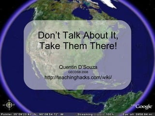
- 1. Quentin DŌĆÖSouza GECDSB 2008 http://teachinghacks.com/wiki/ DonŌĆÖt Talk About It, Take Them There!
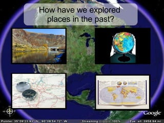
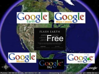
- 2. How have we explored places in the past?
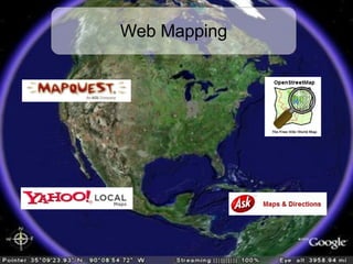
- 3. Web Mapping
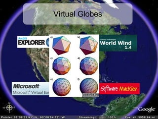
- 5. Free
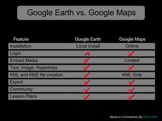
- 6. Google Earth vs. Google Maps Based on a Comparison By David Jakes Google Earth Google Maps Feature Installation Local Install Online Login Embed Media Limited Text, Image, Hyperlinks KML and KMZ file creation KML Only Export Community Lesson Plans
- 7. ╠²
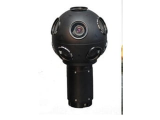
- 8. Based on an image from Popular Mechanics
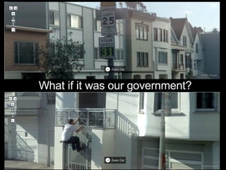
- 9. What if it was our government?
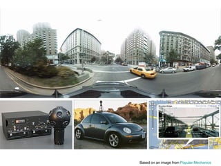
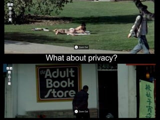
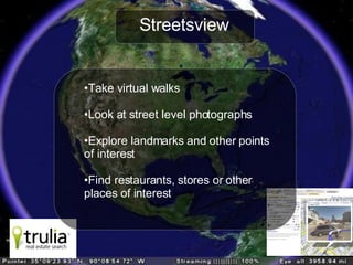
- 11. Streetsview Take virtual walks Look at street level photographs Explore landmarks and other points of interest Find restaurants, stores or other places of interest
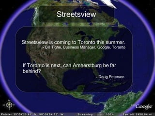
- 12. Streetsview Streetsview is coming to Toronto this summer. - Bill Tighe, Business Manager, Google, Toronto If Toronto is next, can Amherstburg be far behind? - Doug Peterson
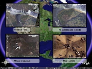
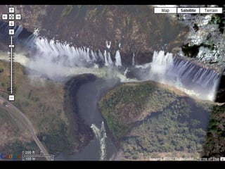
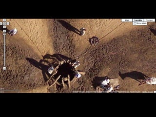
- 13. Victoria Falls The Galapagos Islands Mount Vesuvius Mila - Africa
- 14. ╠²
- 15. ╠²
- 16. ╠²
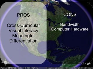
- 17. PROS Cross-Curricular Visual Literacy Meaningful Differentiation CONS Bandwidth Computer Hardware
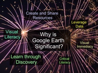
- 18. Why is Google Earth Significant? Leverage Data Visual Immediacy Create and Share Resources Learn through Discovery Visual Literacy Critical Literacy
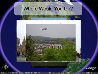
- 19. Where Would You Go? Paris Rome London Home
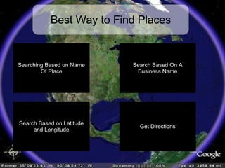
- 20. Best Way to Find Places Not Always Successful Searching Based on Name Of Place Search by keyword or Exact name (using Quotation marks) Much More Accurate But Requires External Resources Find driving directions From one place to another Search Based On A Business Name Search Based on Latitude and Longitude Get Directions
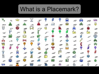
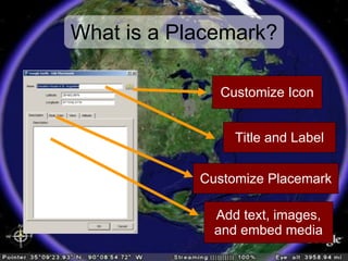
- 21. What is a Placemark?
- 22. What is a Placemark? Title and Label Customize Icon Customize Placemark Add text, images, and embed media
- 23. ╠²
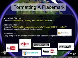
- 24. Formatting A Placemark Add A Web Site Link: <a href=/slideshow/dont-talk-about-it-take-them-there/399392/" http://www.TCDSB.org /slideshow/dont-talk-about-it-take-them-there/399392/"> TCDSB Web Site </a> Adding An Image: <img src=/slideshow/dont-talk-about-it-take-them-there/399392/" http://img68.imageshack.us/my.php?image=99501311up8.gif /slideshow/dont-talk-about-it-take-them-there/399392/"> (Requires image to be already hosted online) Embed Media: Copy and paste the embed code from web sites into the placemark description
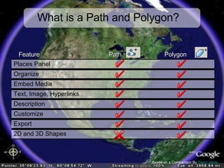
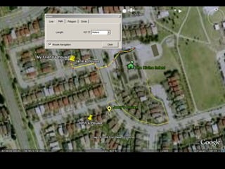
- 25. What is a Path and Polygon? Based on a Comparison By David Jakes Path Polygon Feature 2D and 3D Shapes Export Customize Description Text, Image, Hyperlinks Embed Media Organize Places Panel
- 26. ╠²
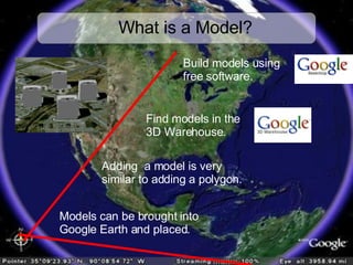
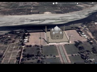
- 27. What is a Model? Models can be brought into Google Earth and placed. Build models using free software. Adding a model is very similar to adding a polygon. Find models in the 3D Warehouse.
- 28. ╠²
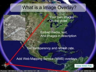
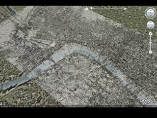
- 29. What is a Image Overlay? Add Web Mapping Service (WMS) overlays Your own images On the globe Set transparency and refresh rate. Embed media, text, And images in description View KMZ File
- 30. ╠²
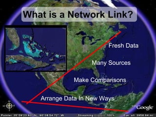
- 31. What is a Network Link? Fresh Data Many Sources Make Comparisons Arrange Data In New Ways
- 32. ╠²
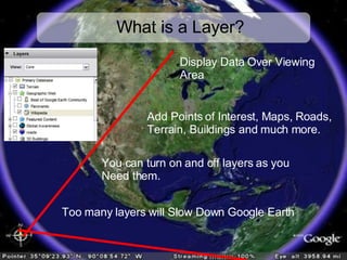
- 33. What is a Layer? Too many layers will Slow Down Google Earth Display Data Over Viewing Area You can turn on and off layers as you Need them. Add Points of Interest, Maps, Roads, Terrain, Buildings and much more.
- 34. ╠²
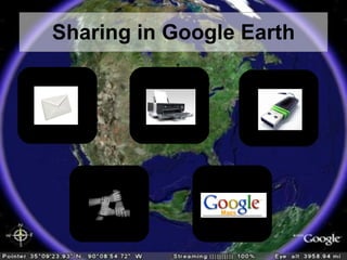
- 35. Sharing in Google Earth
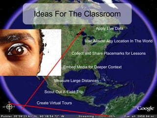
- 36. Ideas For The Classroom Apply Live Data Visit Almost Any Location In The World Measure Large Distances Create Virtual Tours Collect and Share Placemarks for Lessons Embed Media for Deeper Context Scout Out A Field Trip
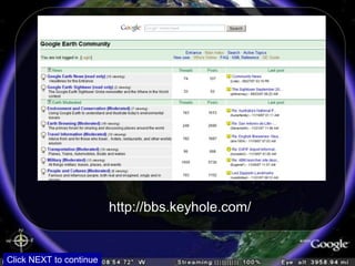
- 37. http://bbs.keyhole.com/ Click NEXT to continue
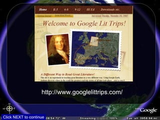
- 40. http://www.googlelittrips.com/ Click NEXT to continue
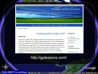
- 41. http://gelessons.com/ Click NEXT to continue
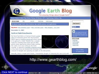
- 42. http://www.gearthblog.com/ Click NEXT to continue
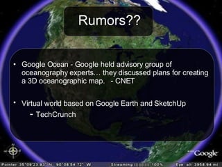
- 43. Rumors?? Google Ocean - Google held advisory group of oceanography expertsŌĆ” they discussed plans for creating a 3D oceanographic map. - CNET Virtual world based on Google Earth and SketchUp - TechCrunch
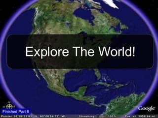
- 44. Explore The World! Finished Part 6