Enhanced Mobility
1 like298 views

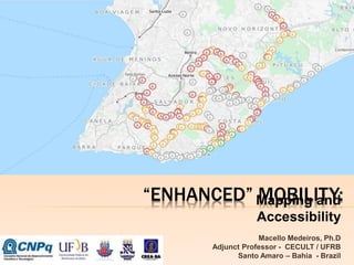
The document discusses the "Right Point" project, which aims to map bus stop accessibility in Salvador, Brazil. The project involves inspecting bus stops within a 6km radius of a hospital to evaluate accessibility based on 12 criteria. Student volunteers were trained to perform inspections and collect geographic data on 194 stops using a classification system of favorable, acceptable, and critical. The results are being mapped using markers colored green, yellow, and red respectively to visualize accessibility levels and identify areas for improvement. The goal is to produce a digital map with georeferenced accessibility data on bus stops to raise awareness and inform urban planning.


More Related Content
Similar to Enhanced Mobility (20)
More from CECULT / UFRB (14)


Recently uploaded (20)


Enhanced Mobility
- 1. âENHANCEDâ MOBILITY: Mapping and Accessibility Macello Medeiros, Ph.D Adjunct Professor - CECULT / UFRB Santo Amaro â Bahia - Brazil
- 2. SITUATION
- 3. PROJECT ï Workgroup of Regional Council of Engineering and Agronomy (CREA-BA). ï Report about a technical inspection in the Bus Stop at the Sarah Kubitschek Hospital, a place of reference in physical rehabilitation. ï Begin the Project âRight Pointâ (Ponto Certo).
- 4. BASIS ï Law 12.587/2012 - National Policy on Urban Mobility ï Norm ABNT NBR 9050 (Brazilian Association of Technical Norms). ï âThe City is a mediation among mediationsâ, âUrban Strategyâ and âNear Order / Fat Orderâ - Henri Lefebvre (1996) in âThe Right of the Cityâ. ï âThe Right to the Open Cityâ â Rob Shields (2013)
- 5. IDEA! ï Make the invisible in visible: Visualization! ï Digital Map or Web Map and Geography Information System (GIS). ï First GIS Map: Epidemiologist John Snow ï The âawarenessâ of urban space. ï Volunteered Geographic Information (VGI).
- 6. OBJECTIVES PROJECT ï Primary ï Producing a digital map of georeferenced bus stops, using GIS with information about the accessibility conditions based on specialized technical inspections. ï Secundary ï Mapping the bus stop within a radius of 6 km from the Sarah Kubitschek hospital in Salvador, identifying its coordinates of latitude and longitude. ï Doing technical inspections based on a form with 12 conditions of accessibility and assess as critical, acceptable and favorable. ï Georrefering the conditions of accessibility in a web map and generating a classification of the bus stops as critical, acceptable and favorable. ï Showing these results by colored markers in the map: red â critical; yellow â acceptable and green â favorable.
- 7. METODOLOGY ï Open Street Map (OSM) Data and Google Transit Data = 215 Bus Stop. ï A form with 12 accessibility conditions. ï Training the students staff by the experts from CREA-BA. ïWork in the field between August 1st to November 1st, collecting data by inspections. ï A collaborative action with stickers: engagement
- 8. ACTION!
- 9. WORKING IN PROGRESS ï 194 inspected and georeferenced bus stop (already included in the base system). ï Classification by colred makers. ï Favorable ï Acceptable ï Critical ï Pop-up with the resume of conditions.
- 10. SCORE ï Each conditions: ï Favorable = 2 points ï Acceptable = 1 point ï Critical = 0 point ï 7 conditions are universal = All sort of disabilities = (Maximum 14 points âFavorableâ) ï Favorable = Between 15 to 24 points ï Acceptable = Between 8 to 14 points ï Critical = Between 0 to 7 points
- 11. EXAMPLE ï Favorable: 0 x 2 = 0 ï Aceptable: 6 x 1 = 6 ï Critical: 5 x 0 = 0 ï Critical = 6 points (Between 0 to 7 points)
- 12. PROJECT âRIGHT POINTâ www.pontocerto.org
- 13. THANK YOU! macellomedeiros@gmail.com @macellomedeiros
Editor's Notes
- #2: HI, MY NAME IS MACELLO MEDEIROS. IâM FROM SALVADOR, BAHIA, BRASIL. ITâS A PLEASURE TO BE HERE IN CHILE FOR THE FIRST TIME AND FOR A GOOD REASON. I THINK THIS IS AN EVENT EXTREMELY NECESSARY FOR THE UNDERSTANDING OF THE CITY, THE URBAN SPACE AND ITS INHABITANTS. MY PRESENTATION IS CALLED âENHANCEDâ MOBILITY: MAPPING AND ACCESSIBILITY. MY PROPOSAL IS TO PRESENT A PROJECT THAT BEST REPRESENTS WHAT I'M CALLING OF "ENHANCEDâ MOBILITY. THE PROJECT âRIGHT POINTâ HAS A FINANCIAL SUPPORT OF CNPQ, A BRAZILIAN AGENCY FOR RESEARCH DEVELOPMENT.
- #3: THESE PHOTOS FROM SALVADOR SHOW SOME SITUATIONS THAT THE PERSON WITH DISABILITIES CAN CONFRONT DURING A SIMPLE WALK THROUGH THE CITY. A LOT OF OBSTACLES (PHYSICAL OR NOT) AND INDIFFERENCE IN THE WAY. WE CAN THINK THAT THERE'S NO SENSIBILITY OR AWARENESS ABOUT THE USE OF URBAN SPACE.
- #4: THESE ISSUES ARE THE CENTRAL POINT IN THE DISCUSSIONS OF THE WORKGROUP IN THE COUNCIL OF ENGINEERING AND AGRONOMY (CREA-BA) THAT I PARTICIPATE AS MEMBER SINCE SEPTEMBER, 2013. ONE OF THE COUNCILâS TASKS IN LAST YEAR WAS THE INSPECTION OF BUS STOP IN SALVADOR. THE FIRST INSPECTION WAS MADE IN THE SARAH KUBITSCHEK HOSPITAL, A PLACE OF REFERENCE IN PHYSICAL REHABILITATION. AFTER THIS, A REPORT WAS PRODUCED AND SENT TO PUBLIC ADMINISTRATION. THIS REPORT WAS THE BEGINNING OF THE PROJECT âRIGHT POINTâ.
- #5: THIS PROJECT WAS BASED IN TWO PILLARS: JURIDICAL AND THEORIC WITH A INTRINSEC RELATIONSHIP, IN MY POINT VIEW. IN BRAZIL, A LAW DEALS IN ITS CHAPTER III, THE âUSER RIGHTSâ, WITH THE RIGHT TO INFORMATION IN DIFFERENT WAYS AND A NORM THAT DEALS WITH ISSUES OF ACCESSIBILITY TO BUILDINGS, EQUIPMENT AND URBAN SPACES AS WIDTH OF SIDEWALKS, ACCESS RAMPS AND REGULATIONS, INSTALLATION OF TACTILE FLOOR, ETC. THE THEORIC PILLAR IS BASED IN CONCEPTS OF HENRI LEFEBVRE (1996) LIKE THE âURBAN STRATEGYâ THAT SAYS âONLY GROUPS, SOCIAL CLASSES, AND CLASS FRACTIONS CAPABLE OF REVOLUTIONARY INIATIVE CAN TAKE OVER AND REALIZE TO FRUITIION SOLUTIONS TO URBAN PROBLEMSâ. ANOTHER CONCEPT, MORE RECENTLY, IS ABOUT THE âRIGHT TO THE OPEN CITYâ BY ROB SHIELDS (2013) THAT SAYS âA RIGHT TO THE CITY ENFRACHISES A NEW CITIZEN, WHO IS NOT SIMPLY A USER OF THE CITY BUT A PARTICIPANT IN ITS CREATION AND INTERPRETATIONâ.
- #6: SO, OUR IDEA TO CONTRIBUTE IN THIS CREATION AND INTERPRETATION OF THE CITY IS MAKE VISIBLE THESE ISSUES THAT ARE INVISIBLE TO THE MOST OF PEOPLE. THROUGH A WEB MAP, WE DECIDE TO USE THE GEOGRAPHIC INFORMATION SYSTEM TO âMAKE VISIBLEâ THE CONDITION OF ACCESSIBILITY IN BUS STOP. THIS IS NOT A ORIGINAL IDEA. THE FIRST IS MAP WAS PRODUCED BY THE EPIDEMIOLOGIST, JOHN SNOW, TO TRACING THE SOURCE OF AĖýCHOLERA OUTBREAK IN SOHO, LONDON, IN 1854. OUR AIM WITH THIS INITIATIVE IS GET THE âAWARENESSâ OF URBAN SPACE, IN SPECIFIC WAY, THE ISSUES OF MOBILITY AND ACCESSIBILITY. THIS PROJECT CAN BE CONSIDERED AS A VGI PROJECT BECAUSE OF THESE CHARACTERISTICS.
- #7: PRIMARY: PRODUCING A DIGITAL MAP OF GEOREFERENCED BUS STOP, USING GIS WITH INFORMATION ABOUT THE ACCESSIBILITY CONDITIONS BASED ON SPECIALIZED TECHNICAL INSPECTIONS. SECUNDARY MAPPING THE BUS STOP WITHIN A RADIUS OF 6 KM FROM THE SARAH KUBITSCHEK HOSPITAL IN SALVADOR, IDENTIFYING ITS COORDINATES OF LATITUDE AND LONGITUDE. DOING TECHNICAL INSPECTIONS BASED ON A FORM WITH 12 CONDITIONS OF ACCESSIBILITY AND ASSESS AS CRITICAL, ACCEPTABLE AND FAVORABLE. GEORREFERING THESE RESULTS IN A WEB MAP AND GENERATING A CLASSIFICATION OF THE BUS STOPS AS CRITICAL, ACCEPTABLE AND FAVORABLE. SHOWING THESE RESULTS BY COLORED MARKERS IN THE MAP: RED â CRITICAL; YELLOW â ACCEPTABLE AND GREEN â FAVORABLE.
- #8: INITIALLY, WE USED A INCOMPLETE DATABASE OF OPEN STREET MAP (OSM) AND IT WAS COMPLEMENTED WITH THE GOOGLE TRANSIT DATABASE TOTALING 215 BUS STOPS. AFTER, WE PRODUCED A FORM WITH 12 ACCESSIBILITY CONDITIONS (USING THE REPORT AS SUPPORT) AND APPLIED IN THE BUS STOP OF SARAH HOSPITAL WITH THE SUPERVISION OF EXPERTS FROM CREA-BA (ENGINEERS, ARCHITECTS, URBANISTS). THE STUDENTS BEGAN THE INSPECTIONS OF BUS STOPS, APPLYING THE FORM FROM AUGUST, 1st. AND THEY WILL PROBABLY FINISH IN NOVEMBER, 1st. FURTHERMORE, A COLLABORATIVE ACTION WAS IMPLEMENTED USING STICKERS IN BUS STOP TO ENGAGE THE USERS.
- #9: SOME PHOTOS OF THE STUDENTS IN THE FIELD AND THE STICKERS USED TO ENGAGE THE PEOPLE IN THE PROJECT. âRIGHT POINTââ âINSPECTED / EXAMINEDâ âCOLLABORATE!â âSENT A PHOTO OR A COMMENT ABOUT THIS EQUIPMENT. USE THE QR CODE READER OR TWITTERâ
- #10: FINALLY, AT THE MOMENT, WE ARE IN THE LAST STAGE OF THE PROJECT AND OUR PROBABLY DATE TO FINISH IS NOVEMBER 1ST. UNTIL NOW, WE CONCLUDED THE INSPECTION AND GEOREFERENCING OF ONE HUNDRED AND NINETY FOUR BUS STOPS, CLASSIFIED BY COLORED MARKERS. IN EACH POINT, WE PROVIDE A SUMMARY OF THE CONDITIONS VERIFIED IN THE INSPECTION.
- #11: FINALLY, AT THE MOMENT, WE ARE IN THE LAST STAGE OF THE PROJECT AND OUR PROBABLY DATE TO FINISH IS NOVEMBER 1ST. UNTIL NOW, WE CONCLUDED THE INSPECTION AND GEOREFERENCING OF ONE HUNDRED AND NINETY FOUR BUS STOPS, CLASSIFIED BY COLORED MARKERS. IN EACH POINT, WE PROVIDE A SUMMARY OF THE CONDITIONS VERIFIED IN THE INSPECTION.
- #13: âACCESSâ âCOVERAGEâ âFLOORâ âRAMPSâ âSIDEWALKâ âETC.â