Erosional and depositional landforms
Download as PPTX, PDF76 likes67,569 views

The basic land-forms created by erosion and deposition in a stream channel. This topic is under the area of fluvial morphology.


More Related Content
What's hot (20)
Similar to Erosional and depositional landforms (20)


Recently uploaded (20)


Erosional and depositional landforms
- 1. (Types and Characteristics) Md. Saiful Islam (2010135017) Nujath Tasnim (2010135027)
- 2. ’üĮ Types of Erosional Landform: ’ü▒V-Shaped Valley ’ü▒Gorge and Canyon ’ü▒Waterfall ’ü▒ Pot hole ’ü▒ River Terraces ’ü▒ River Meanders
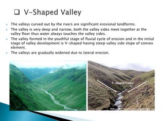
- 3. ’üĮ The valleys curved out by the rivers are significant erosional landforms. ’üĮ The valley is very deep and narrow, both the valley sides meet together at the valley floor thus water always touches the valley sides. ’üĮ The valley formed in the youthful stage of fluvial cycle of erosion and in the initial stage of valley development is V-shaped having steep valley side slope of convex element. ’üĮ The valleys are gradually widened due to lateral erosion.
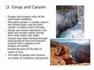
- 4. ’üĮ Gorges and canyons refer to the same basic landform. ’üĮ The word ŌĆścanyonŌĆÖ is widely used in the United States and the term ŌĆśgorgeŌĆÖ is widely used in Europe. ’üĮ Gorge and canyon represents very deep and narrow valleys having very steep valley side slope. ’üĮ Canyon have been formed through long period of time and frequent erosion from a plateau level. Gorges are mainly formed because of the flow of water or lava. ’üĮ The walls of gorges and canyons are made of sandstone and granite.
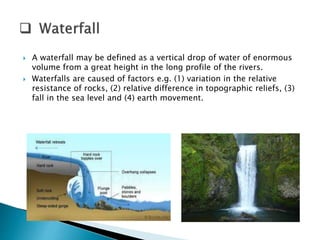
- 5. ’üĮ A waterfall may be defined as a vertical drop of water of enormous volume from a great height in the long profile of the rivers. ’üĮ Waterfalls are caused of factors e.g. (1) variation in the relative resistance of rocks, (2) relative difference in topographic reliefs, (3) fall in the sea level and (4) earth movement.
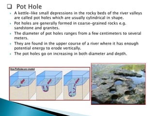
- 6. ’üĮ A kettle-like small depressions in the rocky beds of the river valleys are called pot holes which are usually cylindrical in shape. ’üĮ Pot holes are generally formed in coarse-grained rocks e.g. sandstone and granites. ’üĮ The diameter of pot holes ranges from a few centimeters to several meters. ’üĮ They are found in the upper course of a river where it has enough potential energy to erode vertically. ’üĮ The pot holes go on increasing in both diameter and depth.
- 7. ’üĮ The narrow flat surface on either side of the valley floor are called river terrace. ’üĮ Some times, the river valleys are frequented by several terraces on either side wherein they are arranged in step-like forms. ’üĮ River terraces are generally formed due to dissection of fluvial sediments of flood plains deposited along a valley floor. ’üĮ Terrace represents the level of former valley floors and the remnants of former flood plain.
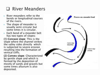
- 8. ’üĮ River meanders refer to the bends or longitudinal courses of the rivers. ’üĮ The shape of meander is usually semi-circular but some times it is circular. ’üĮ Each bend of a meander belt has two types of slopes: (1) Concave slope: This is the slope where the channel strikes the valley sides directly which is subjected to severe erosion resulting into the formation of vertical cliffs. (2) Convex slope: Characterized by gentle slope and which is formed by the deposition of mostly of sands and gravels but some times alluvium is also deposited.
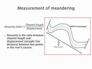
- 9. ĒæåĒæ¢ĒæøĒæóĒæ£ĒæĀĒæ¢ĒæĪĒæ” ĒÉ╝ĒæøĒææĒæÆĒæź = ĒÉČŌäÄĒæÄĒæøĒæøĒæÆĒæÖ ĒæÖĒæÆĒæøĒæöĒæĪŌäÄ ĒÉĘĒæ¢ĒæĀĒæØĒæÖĒæÄĒæÉĒæÆĒæÜĒæÆĒæøĒæĪ ’üČ Sinuosity is the ratio between channel length and displacement (straight line distance) between two points in the riverŌĆÖs course.
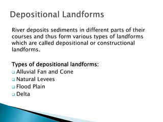
- 10. River deposits sediments in different parts of their courses and thus form various types of landforms which are called depositional or constructional landforms. Types of depositional landforms: ’ü▒ Alluvial Fan and Cone ’ü▒ Natural Levees ’ü▒ Flood Plain ’ü▒ Delta
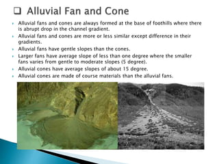
- 11. ’üĮ Alluvial fans and cones are always formed at the base of foothills where there is abrupt drop in the channel gradient. ’üĮ Alluvial fans and cones are more or less similar except difference in their gradients. ’üĮ Alluvial fans have gentle slopes than the cones. ’üĮ Larger fans have average slope of less than one degree where the smaller fans varies from gentle to moderate slopes (5 degree). ’üĮ Alluvial cones have average slopes of about 15 degree. ’üĮ Alluvial cones are made of course materials than the alluvial fans.
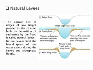
- 12. ’üĮ The narrow belt of ridges of low height parallel to the channel built by deposition of sediments by the flood is called natural levees. ’üĮ Natural levees limit the lateral spread of river water except during the severe and widespread floods.
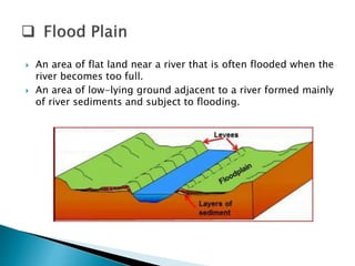
- 13. ’üĮ An area of flat land near a river that is often flooded when the river becomes too full. ’üĮ An area of low-lying ground adjacent to a river formed mainly of river sediments and subject to flooding.
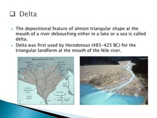
- 14. ’üĮ The depositional feature of almost triangular shape at the mouth of a river debouching either in a lake or a sea is called delta. ’üĮ Delta was first used by Herodotous (485-425 BC) for the triangular landform at the mouth of the Nile river.
- 15. 1. Suitable place in the form of shallow sea and lake shore. 2. Long courses of the rivers. 3. Medium size of sediments. 4. Relatively calm or sheltered sea at the mouth of the rivers. 5. Large amount of sediment supply. 6. Accelerated rate of erosion in the catchment area of concerned river. 7. Almost stable condition of sea coast and oceanic bottom.
- 16. On the basis of shape: Four types 1. Arcuate delta 2. Bird-foot delta 3. Estuarine delta 4. Truncated delta On the basis of growth: Two types 1. Growing delta 2. Blocked delta
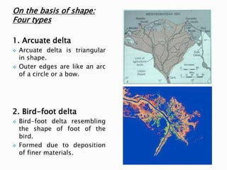
- 17. On the basis of shape: Four types 1. Arcuate delta ’üČ Arcuate delta is triangular in shape. ’üČ Outer edges are like an arc of a circle or a bow. 2. Bird-foot delta ’üČ Bird-foot delta resembling the shape of foot of the bird. ’üČ Formed due to deposition of finer materials.
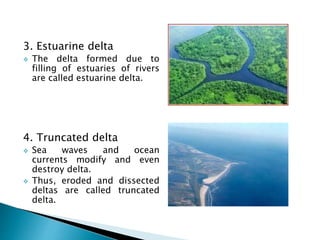
- 18. 3. Estuarine delta ’üČ The delta formed due to filling of estuaries of rivers are called estuarine delta. 4. Truncated delta ’üČ Sea waves and ocean currents modify and even destroy delta. ’üČ Thus, eroded and dissected deltas are called truncated delta.
- 19. On the basis of growth: Two types 1. Growing delta Refers to the continuously seaward growing depositional activities. 2. Blocked delta ’üČ Blocked deltas are those whose seaward growth is blocked by sea wave and ocean currents through their erosional activities. ’üČ The development of deltas may also be hampered due to sudden decrease in the supply of sediments. For more details about erosional and depositional landforms in stream channel: GEOMORPHOLOGY By Savindra Singh FLUVIAL PROCESSES IN GEOMORPHOLOGY By Leopold, Wolman and Miller