![âWe selected an island near OâReilly Island in
the eastern end of Queen Maud Gulf since it had
[Inuit] cultural features and because it was also
suitable for a GPS station,â said Stenton. During
2008, Stenton and Park had conducted surveys
nearby where a few artefacts thought to be
associated with the Franklin expedition had
been found in the 1990s.
Shortly after landing on the island, it was
Stirling who located both the iron fitting from a
davit and the two halves of a wood deck hawse
plug, which were used to cover the hole on a
shipâs deck through which the anchor chain ran
into a locker below.
MOMENT OF TRUTH
Back on the Sir Wilfrid Laurier, Stenton showed
Parks Canada underwater archaeologists Ryan
Harris and Jonathan Moore the items in the
shipâs forward lab. âWhen Doug [Stenton]
showed it to us, we were understandably very,
very excited, not just the context of the find and
identifying broad arrow marks, but getting a
pretty good feeling from what it was,â says Harris.
Taking advantage of the warm weather and
ice-free, calm conditions in the Queen Maud
Gulf, Harris and Moore, working off Parks
Canadaâs Investigator, began surveying the
nearby seabed.
Working in shallow waters, there was a great
deal of concern regarding maintaining the
altitude of the sonar towfish above the seabed.
Harris and Moore were both watching the sonar
monitor at the precise moment that the wreck of
one of Franklinâs ships scrolled down the screen.
âI donât think it was even halfway onto the
monitor when I shouted out, âthatâs it, thatâs itâ
and thatâs when a lot of excitement broke out in
the Investigator,â recalls Harris. âThere were high
tens and hugs all around and a lot of shouting
and arms held up in triumph.â
The side-scan sonar produced stunning
imagery of a 19th century wreck lying 11 metres
underwater, one that was intact and in pristine
condition. But it needed further verification
before it could be announced to the world.
On 7 September, with bad weather moving in,
the Investigator and its crew returned to the
wreck site with an ROV to capture the first film
of what was subsequently identified as Erebus.
It was on the basis of those images that Marc-
Andre Bernier, the Underwater Archaeology
Teamâs manager and senior underwater
archaeologist, confirmed that one of Franklinâs
ships had been found.
THE FINAL WORD
On 9 September, Bernier, Harris and Moore
along with Geiger, Balsillie and other senior
partners of the 2014 Victoria Strait Expedition
appeared at a press conference in Ottawa to
announce to the world that one of Franklinâs
ships had been found.
Prime Minister Stephen Harper said, âThis is
truly a historic moment for Canada. Franklinâs
ships are an important part of Canadian history
given that his expeditions, which took place
nearly 200 years ago, laid the foundations of
Canadaâs Arctic sovereignty.â
The following day, Bernier and his team
returned to the wreck site to start diving, but
extreme weather closed the Parks Canada
diving operations down after only two days. Ice
similar to that which had filled the Victoria Strait
was returning to Queen Maud Gulf. The
expeditionâs window was closing.
Filippo Ronca, a Parks Canada underwater
archaeologist, described the condition of
Erebus: âThe hull itself is amazingly intactâĶ
Sections of the main deck are missing or have
collapsed. In particular several large beams that
would have supported the deck are now
exposed along the port side, which allowed for
unobstructed viewing inside the hull and to the
deck below.â
According to Geiger, what is inside that hull
has the potential to clear up the unknown
around the expeditionâs destruction. âBecause
there were no survivors, the ships themselves
have the last word,â he says. âErebus â and Terror
when she is found â represent the last chance
we have to better understand the expeditionâs
final months and ultimate destruction. We may
finally know the fate of Franklin.â
Joseph Frey is chair of the Royal Canadian
Geographical Societyâs College of Fellows
50 miles
50 km
north
Gjoa
Haven
Cambridge
Bay
Victoria
Island
Bothnia
Peninsula
Prince of Wales
Island
King
William
Island
N U N A V U T
C A N A D A
VictoriaStrait
McClintockChannel
GulfofBooth
ia
F
ranklinStrait
Queen Maud
Gulf
site of the
Erebus
W h y E r eb u s m atte r s
John Geiger, the Chief Executive of the Royal Canadian Geographical
Society explains why the discovery of Franklinâs missing ship is one
of the most important archaeological finds in exploration history
For one who has been caricaturized as the stolid embodiment of
Britannic hubris, Captain Sir John Franklin is remarkable for his
diversity. We know the essentials of the story of the 1845â1848 British
Arctic Expedition Franklin commanded â the deaths of all 129 officers
and men, the bone scatter marking the path of their attempted retreat
from the Arctic, and of course the disappearance of the two
exploration ships HMS Erebus and HMS Terror. It was a mass disaster
played out over several years, but it is often also very personal to
Franklin himself.
In her excellent introduction to my book Frozen In Time: The Fate of
the Franklin Expedition, Margaret Atwood writes about the different
manifestations of Franklin over time, how he evolved with our
culture, from the romantic Victorian hero of self (and more
generalized) sacrifice, who Atwood calls Franklin Aloft, before coming
heavily down to Earth as the Halfwit Franklin by the second half of
the 20th century, an allusion to the failure to adopt Inuit customs.
In recent years, Franklinâs reputation has been on the move again,
transformed into what might be called Franklin Disinterred, by the
research led by my bookâs coâauthor, Owen Beattie, who applied
forensic science to the Franklin mystery. In the process, the first
physical evidence was found to support Inuit testimony of
cannibalism among the last men standing, accounts carried to
London by the overland explorer John Rae, setting off a round of
knickerâtightening and racist slurs.
The research also demonstrated that scurvy was a factor, as
historians had long surmised, and produced the additional revelation
that lead poisoning was afoot on the expedition, with the suspected
culprit being the tinned food supply. Franklinâs leadership abilities, or
lack thereof, matter a lot less if lead had been coursing through his
system and he was, in Atwoodâs words, a victim âof bad packaging.â
Now, with the location of a ghostly, remarkably well-preserved hulk
resting in frigid water in the general vicinity of where the Inuit had
told 19th century searchers that a ship had indeed sunk, we have yet
another Franklin: Franklin Submerged. This latest incarnation may
prove to be the most fascinating and revelatory yet.
The wreck found by the 2014 Victoria Strait Expedition was HMS
Erebus, and if we were to ever only find one of the ships, Erebus
would be the one. It is Franklinâs ship. Within the largely intact hull is
his large cabin, the place where he lived, its builtâin map drawers
presumably filled with the charts he studied. Quite possibly his
personal possessions are there, and who knows, maybe his bones,
too, if the theories of some are correct. Erebus is, after all, where
Franklin likely died.
Grandiose claims have been made for the significance of the find. It
has been likened in archeological terms to the 1922 opening of
Tutankhamunâs tomb. Certainly, in the context of exploration history,
itâs hard to imagine a more important discovery. There are plans
underway to search for, as an example, Sir Ernest Shackletonâs
Endurance, a tremendously famous ship that was crushed and sank
in the ice of the Weddell Sea in 1915.
But we know what happened to Shackleton. His was the polar
opposite of Franklinâs in that he and the Enduranceâs crew all lived. To
find his ship would be a wonderful thing, but what might we learn?
Thatâs where Erebus differs from Endurance, and others, including the
most famous of all shipwrecks, RMS Titanic. That is what makes this
discovery so important, the possibility of what we might learn.
âThe sonar image of the wreck wasnât
even halfway onto the monitor when
I shouted out, âthatâs it, thatâs itâ
douglasstenton
ABOVE: Robert Park
(University of Waterloo),
Andrew Stirling
(Transport Canada) and
Douglas Stenton
(Government of
Nunavut) show where
the iron davit fitting,
found by Stirling, would
have been located on the
HMS Erebus
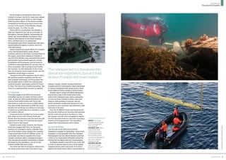
December 2014 | 3534 | December 2014
expedition
The search for Franklin](https://image.slidesharecdn.com/04f58058-7cf0-4245-b13c-8cbd9eae7eeb-150614101535-lva1-app6891/85/Franklin-Dec14-3-320.jpg)
Franklin-Dec14
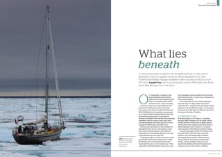
- 1. December 2014 | 31 O n 1 September, Canadian Coast Guard helicopter pilot Andrew Stirling set his twin-engine Bo 105 down on a remote island off the mainland Arctic coast of Canada. He was ferrying two archaeologists for the Government of Nunavut, whose work was focussed on land sites associated with the lost 1845â48 British Arctic Expedition commanded by Sir John Franklin. Douglas Stenton, the lead archaeologist and director of heritage for Nunavut, and Robert Park had been documenting expedition sites for several years, their work complimenting the sea-based search by Parks Canada for HMS Erebus and HMS Terror. Stenton was interested in a stone feature he had sighted from the air, and wanted a closer look. It was Stirling, however, who spotted a rusted piece of iron leaning against a rock near a long abandoned Inuit camp site. âFinding the object, itâs hard to put into words,â says Stirling. âAt the time, seeing it and calling Bob (Park) over to let him know what I had found behind a rock, his first words were âThis is a good findâ and then Stenton came over, to do his investigation and he spotted the two (Royal Navy) broad arrows... it was a very exciting and a very proud moment.â The rusted davit, part of a lifting apparatus from the deck of a ship, might have meant relatively little â another bit of expedition related ephemera carried off the lost ships â but it proved instead to be a vital lead in a 168-year-old search for clues to the fate of Franklin. A CONFIDENT START Nine days earlier, on 23 August, a Canadian warship, HMCS Kingston, sat at anchor off the coastal hamlet of Pond Inlet, on Baffin Islandâs north coast. There, leaders of the 2014 Victoria Strait Expedition were invited to a reception with Canadian Prime Minister, Stephen Harper. This was the largest search for Franklin since the early 1850s, with four ships, assorted support craft and leading edge Canadian technology. Most notable of these was the âArctic Explorerâ Autonomous Underwater Vehicle, with its synthetic aperture sonar, operated by Defence Research Development Canada, an arm of the countryâs military. 30 | December 2014 josephfrey What lies beneath A chance encounter resulted in the breakthrough set to solve one of exploration historyâs biggest mysteries. What happeded to Sir John Franklinâs Northwest Passage expedition which resulted in the loss of all 129 men? Joseph Frey tells the amazing story of how HMS Erebus was finally found after 168 years lost in the Arctic LEFT: unexpected ice proved to be a major obstacle for the 2014 Victoria Strait Ezxpedition expedition The search for Franklin
- 2. On the bridge of the Kingston there was a moment of prayer, two Arctic maps were signed, and then glasses were raised, as John Geiger, Chief Executive Officer of The Royal Canadian Geographical Society, proposed a toast to the success of the search. Prime Minister Harper raised his glass. âTo a find,â he said. Others did too, among them Jim Balsillie, a high-tech legend for his role as co-founder of BlackBerry, Geordie Dalglish, representing his familyâs W. Garfield Weston Foundation, Rear Admiral John Newton of the Royal Canadian Navy, and Ryan Harris, an underwater archaeologist with Parks Canada who had been spearheading the agencyâs search, now in its sixth field season. Harper himself has a great affinity for Canadaâs Arctic and has developed a deep, almost scholarly, interest in the history of exploration of the region, particularly relating to Franklin. It was the Prime Minister who assembled the broad partnership of government agencies, private foundations and businesses, and he made his confidence and expectation for success clear to those assembled. âWeâre going to find Franklin, this summer,â he said adamantly. A short time later, the Kingston would weigh anchor, and the expedition would begin in earnest. âThe goal of the 2014 expedition was to marry the greatest possible capability and the very best available technology, and bring them into two possible areas in which the missing ships could be located,â said Geiger, author of Frozen In Time: The Fate of the Franklin Expedition. âBut none of us expected what we were up against.â ICY WATERS The major target of the 2014 Victoria Strait Expedition was the so-called ânorthern search zoneâ, an area of 1,400 square kilometres in the Victoria Strait where Erebus and Terror had been beset in multi-year sea ice in 1846, before they were finally abandoned in 1848, the crews already sick and dying, according to a message scrawled on an Admiralty form and left in a cairn by Franklinâs officers. A forecast by the Canadian Ice Service noted that, while sea ice in the Victoria Strait was thicker than the previous year, the strait was still expected to be clear of ice by time the search fleet arrived in late August. Instead of open water, however, the Victoria Strait was clogged with thick ice, the worst summer ice coverage in nearly a decade. Only two of the flotillaâs seven vessels, the Canadian Coast Guard Ship (CCGS) Sir Wilfrid Laurier, an ice breaker, and the ice-capable One Ocean Voyager, would be able to navigate through it. This unexpected situation threatened to defeat the hopes for the expedition, just as ice had broken Franklin 168 years earlier. The result was that the Kingston, without any ice rating, would never reach the search area. Instead, Voyager, already transporting Parks Canadaâs boat R/V Investigator, had to backtrack to retrieve equipment that would prove critical to the ability of Parks Canada to verify Erebus. Another search vessel, the Martin Bergmann, was forced to stay in the south search zone, close to the mainland coast, where exhaustive surveys by Parks Canada in earlier years had failed to yield anything of interest, and yet which remained a target area because of Inuit accounts to early searchers that indicated a ship had sunk in the area. Even the Sir Wilfrid Laurier was forced south, because the small survey launches that operated off of it could not survey in the thick ice. Only the Voyager was left, and it struggled to deploy the AUV because of the ice, only ever covering a fraction of its assigned area. The expedition looked like it was poised to end in failure. ISLAND HOPPING The fortunes of the 2014 Victoria Strait Expedition changed on September 1 when Scott Youngblut, a hydrographer with the Canadian Hydrographic Service offered Stenton and Park a seat on the coast guard helicopter piloted by Stirling that he shared with the archaeologists. Youngblut needed a land site to set up his GPS in order to improve the accuracy of his seabed mapping and he wasnât particular as to which island in the South Search Zone it was located on. The unexpected ice threatened to defeat the expedition, just as it had broken Franklin 168 years earlier josephgrey(2);ThierryBoyer/ParksCanada ABOVE: One Ocean Voyager sailing through sea ice and fog in the Victoria Strait; OPPOSITE, TOP: astern of the wreck, Parks Canada underwater archaeologist Filippo Ronca measures the muzzle bore diameter of one of two cannons found on the site; OPPOSITE, BELOW: One Ocean Voyager recovers an AUV from the Victoria Strait December 2014 | 3332 | December 2014 expedition The search for Franklin
- 3. âWe selected an island near OâReilly Island in the eastern end of Queen Maud Gulf since it had [Inuit] cultural features and because it was also suitable for a GPS station,â said Stenton. During 2008, Stenton and Park had conducted surveys nearby where a few artefacts thought to be associated with the Franklin expedition had been found in the 1990s. Shortly after landing on the island, it was Stirling who located both the iron fitting from a davit and the two halves of a wood deck hawse plug, which were used to cover the hole on a shipâs deck through which the anchor chain ran into a locker below. MOMENT OF TRUTH Back on the Sir Wilfrid Laurier, Stenton showed Parks Canada underwater archaeologists Ryan Harris and Jonathan Moore the items in the shipâs forward lab. âWhen Doug [Stenton] showed it to us, we were understandably very, very excited, not just the context of the find and identifying broad arrow marks, but getting a pretty good feeling from what it was,â says Harris. Taking advantage of the warm weather and ice-free, calm conditions in the Queen Maud Gulf, Harris and Moore, working off Parks Canadaâs Investigator, began surveying the nearby seabed. Working in shallow waters, there was a great deal of concern regarding maintaining the altitude of the sonar towfish above the seabed. Harris and Moore were both watching the sonar monitor at the precise moment that the wreck of one of Franklinâs ships scrolled down the screen. âI donât think it was even halfway onto the monitor when I shouted out, âthatâs it, thatâs itâ and thatâs when a lot of excitement broke out in the Investigator,â recalls Harris. âThere were high tens and hugs all around and a lot of shouting and arms held up in triumph.â The side-scan sonar produced stunning imagery of a 19th century wreck lying 11 metres underwater, one that was intact and in pristine condition. But it needed further verification before it could be announced to the world. On 7 September, with bad weather moving in, the Investigator and its crew returned to the wreck site with an ROV to capture the first film of what was subsequently identified as Erebus. It was on the basis of those images that Marc- Andre Bernier, the Underwater Archaeology Teamâs manager and senior underwater archaeologist, confirmed that one of Franklinâs ships had been found. THE FINAL WORD On 9 September, Bernier, Harris and Moore along with Geiger, Balsillie and other senior partners of the 2014 Victoria Strait Expedition appeared at a press conference in Ottawa to announce to the world that one of Franklinâs ships had been found. Prime Minister Stephen Harper said, âThis is truly a historic moment for Canada. Franklinâs ships are an important part of Canadian history given that his expeditions, which took place nearly 200 years ago, laid the foundations of Canadaâs Arctic sovereignty.â The following day, Bernier and his team returned to the wreck site to start diving, but extreme weather closed the Parks Canada diving operations down after only two days. Ice similar to that which had filled the Victoria Strait was returning to Queen Maud Gulf. The expeditionâs window was closing. Filippo Ronca, a Parks Canada underwater archaeologist, described the condition of Erebus: âThe hull itself is amazingly intactâĶ Sections of the main deck are missing or have collapsed. In particular several large beams that would have supported the deck are now exposed along the port side, which allowed for unobstructed viewing inside the hull and to the deck below.â According to Geiger, what is inside that hull has the potential to clear up the unknown around the expeditionâs destruction. âBecause there were no survivors, the ships themselves have the last word,â he says. âErebus â and Terror when she is found â represent the last chance we have to better understand the expeditionâs final months and ultimate destruction. We may finally know the fate of Franklin.â Joseph Frey is chair of the Royal Canadian Geographical Societyâs College of Fellows 50 miles 50 km north Gjoa Haven Cambridge Bay Victoria Island Bothnia Peninsula Prince of Wales Island King William Island N U N A V U T C A N A D A VictoriaStrait McClintockChannel GulfofBooth ia F ranklinStrait Queen Maud Gulf site of the Erebus W h y E r eb u s m atte r s John Geiger, the Chief Executive of the Royal Canadian Geographical Society explains why the discovery of Franklinâs missing ship is one of the most important archaeological finds in exploration history For one who has been caricaturized as the stolid embodiment of Britannic hubris, Captain Sir John Franklin is remarkable for his diversity. We know the essentials of the story of the 1845â1848 British Arctic Expedition Franklin commanded â the deaths of all 129 officers and men, the bone scatter marking the path of their attempted retreat from the Arctic, and of course the disappearance of the two exploration ships HMS Erebus and HMS Terror. It was a mass disaster played out over several years, but it is often also very personal to Franklin himself. In her excellent introduction to my book Frozen In Time: The Fate of the Franklin Expedition, Margaret Atwood writes about the different manifestations of Franklin over time, how he evolved with our culture, from the romantic Victorian hero of self (and more generalized) sacrifice, who Atwood calls Franklin Aloft, before coming heavily down to Earth as the Halfwit Franklin by the second half of the 20th century, an allusion to the failure to adopt Inuit customs. In recent years, Franklinâs reputation has been on the move again, transformed into what might be called Franklin Disinterred, by the research led by my bookâs coâauthor, Owen Beattie, who applied forensic science to the Franklin mystery. In the process, the first physical evidence was found to support Inuit testimony of cannibalism among the last men standing, accounts carried to London by the overland explorer John Rae, setting off a round of knickerâtightening and racist slurs. The research also demonstrated that scurvy was a factor, as historians had long surmised, and produced the additional revelation that lead poisoning was afoot on the expedition, with the suspected culprit being the tinned food supply. Franklinâs leadership abilities, or lack thereof, matter a lot less if lead had been coursing through his system and he was, in Atwoodâs words, a victim âof bad packaging.â Now, with the location of a ghostly, remarkably well-preserved hulk resting in frigid water in the general vicinity of where the Inuit had told 19th century searchers that a ship had indeed sunk, we have yet another Franklin: Franklin Submerged. This latest incarnation may prove to be the most fascinating and revelatory yet. The wreck found by the 2014 Victoria Strait Expedition was HMS Erebus, and if we were to ever only find one of the ships, Erebus would be the one. It is Franklinâs ship. Within the largely intact hull is his large cabin, the place where he lived, its builtâin map drawers presumably filled with the charts he studied. Quite possibly his personal possessions are there, and who knows, maybe his bones, too, if the theories of some are correct. Erebus is, after all, where Franklin likely died. Grandiose claims have been made for the significance of the find. It has been likened in archeological terms to the 1922 opening of Tutankhamunâs tomb. Certainly, in the context of exploration history, itâs hard to imagine a more important discovery. There are plans underway to search for, as an example, Sir Ernest Shackletonâs Endurance, a tremendously famous ship that was crushed and sank in the ice of the Weddell Sea in 1915. But we know what happened to Shackleton. His was the polar opposite of Franklinâs in that he and the Enduranceâs crew all lived. To find his ship would be a wonderful thing, but what might we learn? Thatâs where Erebus differs from Endurance, and others, including the most famous of all shipwrecks, RMS Titanic. That is what makes this discovery so important, the possibility of what we might learn. âThe sonar image of the wreck wasnât even halfway onto the monitor when I shouted out, âthatâs it, thatâs itâ douglasstenton ABOVE: Robert Park (University of Waterloo), Andrew Stirling (Transport Canada) and Douglas Stenton (Government of Nunavut) show where the iron davit fitting, found by Stirling, would have been located on the HMS Erebus December 2014 | 3534 | December 2014 expedition The search for Franklin