The Arctic: Back on the Map
Download as PPTX, PDF1 like286 views

This document discusses the increasing accessibility and activity in the Arctic region due to climate change and reduced sea ice. It provides a brief history of Arctic exploration and operations by the US Coast Guard since the 19th century. It then outlines current and future challenges and opportunities in the Arctic relating to transportation, resource extraction, tourism, indigenous populations, science, environmental issues, and geopolitics. The US Coast Guard plays an important role in Arctic operations but faces challenges maintaining its icebreaker fleet and capacity.


More Related Content
Similar to The Arctic: Back on the Map (20)
Recently uploaded (20)


The Arctic: Back on the Map
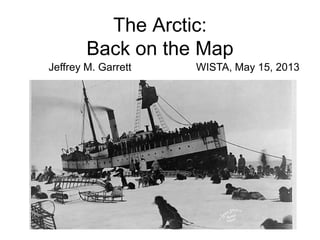
- 1. The Arctic: Back on the Map Jeffrey M. Garrett WISTA, May 15, 2013
- 3. The Northwest PassageŌĆ” in 1846 HMS Erebus, Sir John Franklin
- 4. In 1957ŌĆ” U.S. Coast Guard Cutters Storis, Spar and Bramble
- 5. And in 2011 Motor Yacht Arcadia An ice-free waterway!
- 6. The U.S. is an Arctic Nation? ŌĆó Alaska! ŌĆó 1867 - ŌĆ£SewardŌĆÖs FollyŌĆØ made the United States an Arctic nation ŌĆó Revenue cutters became the primary government presence in Arctic & sub-Arctic waters
- 7. Early Arctic Operations ŌĆó Exploration & Science ŌĆó Enforcement of environmental laws ŌĆó Civil government & community assistance
- 8. Bering Sea Patrol Annual patrols into the Bering Sea and Arctic Ocean until 1941
- 9. World War II ŌĆō conflict on the margins In the West ŌĆ” ŌĆó Kiska & Attu invaded & retaken ŌĆó The Alaska Highway built
- 10. In the East ŌĆ” Wartime operations in Greenland ŌĆó Securing a strategic location ŌĆó Capturing German weather stations ŌĆó Building modern icebreakers
- 11. 1950ŌĆÖs ŌĆō Cold War in the Arctic ŌĆó Arctic air bases ŌĆó Defense early warning radar sites ŌĆó Northwest Passage
- 12. 1960ŌĆÖs and 1970ŌĆÖs -- Oil ŌĆó Prudhoe Bay discovery ŌĆó 1969 - SS Manhattan transited NW Passage ŌĆó Alaska Pipeline built
- 13. 1980ŌĆÖs and 1990ŌĆÖs -- Science ŌĆó Declining need for Arctic logistics ŌĆó Cold War-related Defense research endsŌĆ”but general science demands increase ŌĆó First indications of climate change in the Arctic
- 14. 2000ŌĆÖs ŌĆō A Flurry of Activity ŌĆó Transportation ŌĆó Oil & Gas resources ŌĆó Tourism & adventure travel ŌĆó Native Peoples ŌĆó Science ŌĆó Environmental concerns ŌĆó Geopolitics
- 15. Transportation ŌĆó Less ice = more access ŌĆó Northern Sea RouteŌĆ” a new waterway
- 16. Transportation ŌĆó Northwest Passage ŌĆ” steady increases in traffic ŌĆó Arctic Marine Shipping Assessment - 2009 ŌĆó Bering Strait marine traffic transits U.S. waters
- 17. Oil and Gas Development ŌĆó Huge potential ŌĆō U.S. Geological Survey estimates ŌĆó Russia ŌĆ” aggressive development ŌĆó Norway ŌĆó Canada ŌĆó Greenland
- 18. Oil and Gas ŌĆó Alaska ŌĆō offshore potential, declining onshore production ŌĆó Shell Oil ŌĆō the battle
- 19. Tourism & Adventure Travel ŌĆó Growing popularity ŌĆ” especially ecotourism ŌĆó Greenland & Svalbard well-established ŌĆ” North America & Russia growing ŌĆó Cruises ŌĆ” and yachts
- 20. But ŌĆ” not much of a safety net!
- 21. Native Peoples ŌĆó Increasing native consciousness ŌĆó Inuit Circumpolar Council ŌĆó Nunavut in Canada ŌĆó Alaska native corporations
- 22. Science Still tremendous demand for research access: ŌĆó Relatively little data ŌĆó Climate change effects ŌĆó Better data for development?
- 23. Environmental Concerns ŌĆó More science needed? ŌĆó The Arctic as a preserve? ŌĆó Native perspectives
- 24. Geopolitics ŌĆó Arctic Council - 1996 ŌĆó Russia ŌĆ£plants the flagŌĆØ in 2007 ŌĆó Sovereignty issues ŌĆō extended continental shelf claims ŌĆó Non-Arctic players?
- 25. Geopolitics ŌĆō claims of the extended continental shelf US ŌĆō Canadian cooperation in gathering data
- 26. The Venerable Wind Class ŌĆó 7 Ships ŌĆó 269 feet LOA ŌĆó 6,300 tons ŌĆó 10,000 SHP ŌĆó Crew 168+
- 27. Polar Star and Polar Sea ŌĆó Operational 1976, 1977 ŌĆó Length - 399 feet ŌĆó Displacement - 13,000 t ŌĆó Propulsion - DE & GT ŌĆó 60,000 shaft horsepower ŌĆó Continuous icebreaking - 6+ feet
- 28. Polar-Class Capabilities ŌĆó WorldŌĆÖs most powerful non-nuclear icebreakers ŌĆó Complex engineering plant ŌĆó Flight deck & hangar ŌĆó Multiple boat types ŌĆó Cranes, cargo spaces ŌĆó Basic science equipment and labs
- 29. Healy ŌĆó Delivered in 2000 after years of requirements analysis & design studies ŌĆó Multi-mission--but to meet the growing demand for Arctic research ŌĆó Length - 420 feet ŌĆó Displacement - 16,000 t ŌĆó Power - 30,000 Shp ŌĆó Continuous icebreaking: 4.5 feet
- 30. Healy Capabilities ŌĆó Efficient DE-integrated propulsion plant ŌĆó Extensive science facilities & sensors ŌĆó Flight deck & hangar ŌĆó Multiple boat types ŌĆó Cranes & cargo spaces ŌĆó 50+ science/passenger accommodations
- 32. Polar Issues for the U.S. ŌĆó Transportation safety & security ŌĆó Environmental protection vs. oil development ŌĆó Northern Alaska communities
- 33. Polar Issues for the U.S. (ContŌĆÖd) ŌĆó Turning policy into capability ŌĆó International leadership & Law of the Sea
- 34. The Rest of the World ŌĆó Russia ŌĆó European Union Increasing attention and investment ŌĆ”. ŌĆó Canad a ŌĆó China ŌĆó Korea ŌĆó Japan ŌĆó South Africa ŌĆó Chile
- 35. Discussion?
- 36. And What About Antarctica? ŌĆó Historically & politically unique ŌĆó The Antarctic Treaty ŌĆō 1960 ŌĆó A foreign policy success story
- 37. U.S. Leadership ŌĆó Continuous presence ŌĆó Diplomatic engagement ŌĆó 3 year-round bases ŌĆó Robust logistics capabilities
- 38. Future Pressures ŌĆó Territorial claims & potential conflict ŌĆó Tourism ŌĆó Resources, resources, resourcesŌĆ”.
Editor's Notes
- #3: The standard Mercator projectionŌĆ”distorts the polar regions and usually leaves them ŌĆ£off the map.ŌĆØ Only shows to 80 degrees N and S.
- #5: Storis, Spar and BrambleŌĆ”5th, 6th and 7th transits of NW Passage
- #6: 145th transit of NWPŌĆ”.160 as of mid-Oct 2011
- #7: Revenue cutters became the only federal presence in the Aleutians, Bering Sea and Arctic coast of Alaska.
- #11: Denmark invaded April 1940Cryolite, a mineral ore used for aluminumŌĆ”major mine at Invigtut in SW GreenlandŌĆ”sodium hexaflouroaluminateWeather informationŌĆ”valuable for U-boat operations and flight operations in Europe
- #13: Oil confirmed in Prudhoe Bay area of AlaskaŌĆÖs North Slope, late 60ŌĆÖsSS Manhattan, [built 1962], retrofitted with an icebreaking bow. Test voyage of NWP east to Prudhoe Bay, loaded a symbolic barrel of oil and returned, with icebreaker assistance.Winter trip showed that year-round transit impossible.Alaska Pipeline became preferred option for Prudhoe Bay oilŌĆ”but involved far-reaching issues such as resolution of Native Alaskan land claims.
- #16: Shipping route from N. Europe to China/Japan/Korea can save 4000 nautical miles and 22 daysŌĆ”time savings, fuel savings, other risksŌĆ”.After ambivalence about its Northern Sea Route, Russia is now actively promoting it ŌĆ” Icebreaker services, regulations, search & rescue bases, new icebreakers2 commercial ships in 2009, 18 in 2011ŌĆ”.47 vessels, 1.3M tons of cargo in 2012.
- #17: NWPŌĆ” 160 ship transits since Amundsen in 1903-06ŌĆ”.16 of these in 2011 ŌĆ” but no commercial shipping as with NSRAMSAŌĆ”2012ŌĆ”1st submarine fiber optic cables laid in the Arctic, UK to JapanŌĆ”.linking Arctic communitiesBoth Arctic routes use the Bering Strait ŌĆ” US watersTransits increasing 30-40% per yearŌĆ”.325 vessel transits in 2010$1 billion in goodsCG planning traffic lanes and improved navigation
- #18: USGS estimates 2008: 400 billion bbl of oil in the Arctic, 6.7% of worldŌĆÖs proven oil, 13% of undiscovered oilŌĆ”even greater percentages of natural gas (26%/30%)RussiaŌĆ”farthest ahead, most aggressive Arctic programŌĆ”.oil to replace declining older fieldsRecent deal between Exxon & Rosneft, the state oil companyMarch 2012ŌĆöallowing private companies access (poor results from state-owned efforts), plus new tax systemNorwayŌĆ”recently settled the offshore Barents Sea boundary with Russia (July 2011)ŌĆ”.Statoil exploring program in the BarentsŌĆ”33 new Arctic leases this year.CanadaŌĆ”Arctic Beaufort Sea very active in the 1970ŌĆÖs & 80ŌĆÖsŌĆ”.300,000 barrels producedBy end of the 80ŌĆÖs, production stopped due to new, more accessible sources2008 -2010ŌĆ”.BP and Chevron have won bids for new explorationGreenlandŌĆ”controversial exploratory drilling off the west coastOpposition by Greenpeace, which is disliked in GreenlandSept 2011ŌĆ”6th dry well, over $1.2 billion spentŌĆ”early 2012 Cairn Energy says no further plans
- #19: In 2005 and 2008, US government auctioned offshore leases in Beaufort and Chukchi SeasŌĆ”area available went from 9M acres to 77M acres.Shell Oil spent over $2B in leasesŌĆ”.initial exploratory drilling planned in 2007 postponed by lawsuits.2012 ŌĆō permitting complete, Shell planning to drill up to 10 exploratory wells over the next 2 years22 ships, including 2 icebreaking anchor-handing supply ships built for the jobEarly March 2012ŌĆöShell granted an restraining order against Greenpeace, for non-interference with vesselsMaturing fields around Prudhoe Bay are decliningŌĆ”.Alaska Pipeline now at 1/3 capacity and declining 7% per yearŌĆ”will soon be unusable. [Max 2.1M bbl/day; 2000 1.0M bbl/day; 2011 650K bbl/day]
- #20: Estimated 1 million visitors per year, afloat & ashoreŌĆ”.growing ecotourismSince the late 70ŌĆÖs, Russian icebreaker tours to the North Pole, $23 to 33k.7 cruise ships with 3,000 visitors to Alaska north coastline in summer 2011ŌĆ”compares to 70 ships & 150,000 tourists to GreenlandRussia has recently designated a National Park of the Arctic
- #21: For ship-based tourism, most of the Arctic isPoorly chartedLacks navigational aids and informationHas no emergency assistance resourcesProvides minimal communication servicesAnd accidents are happeningŌĆ”.2010 saw 3 large ship groundings in the NWPŌĆ”MV Clipper Adventurer, hard aground with 128 pax & 69 crew on an uncharted rockŌĆ”.had to evacuate to a CCG icebreakerOther 2 groundings were tankers, small but considerable pollution risk
- #22: Arctic native peoples marginalized for many years, but increasingly demanding a voice in the ArcticŌĆÖs futureŌĆ”.Alaska Pipeline and resolution of native land claims sparked this consciousness.Inuit Circumpolar Council, an international forum for native groups across international boundaries, began forming in 1977ŌĆ”.represents 150,000 people in the U.S., Canada, Greenland and Russia. Focused on the rights, interests and culture.A new territory, Nunavut, formed in Canada as a result of resolving Canadian native land claimsŌĆ”the size of W. Europe, 33,000 people.Inukshuk = land marker, guide and special or sacred places.The 12 regional Alaska native corporations have brought considerable political and economic clout to Alaska Inupiat and Yupik peoples.GreenlandŌĆ”.57,000 people, 88% Inuit. Home rule in 1979, self-government in 2009ŌĆ”Denmark retains defense & foreign policy responsibilities and provides a subsidy of about 30% of GDP.
- #23: Access is the keyŌĆ”Arctic is the least investigated ocean basin. Nansen-Gakkel Ridge study 10 years ago: ŌĆ£More rocks from the moon than from this ridge system.ŌĆØ
- #24: Environmental issues most visible with regard to oil explorationŌĆ” But also affects transportation, tourism, native desires, even science (research near Alaska must work around whale migrations, noise etc.)Should the Arctic be a preserve, with no development, similar to Antarctica? (more on this to follow). Or is it a matter of controlling development? Pew study (March 2012): 65% of US respondents say more offshore oil & gas drillingŌĆ”.44% in 2010. Lars-Eric Lindblad: ŌĆ£You canŌĆÖt protect what you donŌĆÖt know.ŌĆØ Implication: tourism builds environmental awareness and support.
- #25: Final category of Arctic trends involves the interplay of international politicsŌĆ”Arctic Council is a forum for the 8 Arctic nations, plus the Inuit Circumpolar CouncilŌĆ”1996Things really were stirred up when a Russian expedition used a mini-sub to plant a titanium flag on the sea bed at the North PoleŌĆ”claimed it for Russia and aroused significant press interest.Some have over-played the risk of conflictŌĆ”little likelihood of a shooting war, but disputes abound:Border issues: US-Canada offshore, Canada-GreenlandNWP status: internal waters or international waterway?Rights of non-Arctic nations? China particularlyŌĆ” ŌĆ£The Arctic belongs to all the people around the world.ŌĆØ Twice requested permanent observer status on the Arctic Council, twice refusedCaused the U.S. to update its Arctic Policy in a Presidential Executive Order
- #26: Biggest geopolitical issue: United Nations Convention on the Law of the Sea allows nations to claim rights on continental shelf areas extending beyond the 200-mile exclusive economic zoneŌĆ”in certain circumstances where hydrographic & geological data meets criteriaUS potential for 6 ECS areas, totalling 1 million square kilometersŌĆ”twice the area of California. One of the largest areas is in the Arctic Ocean.The US and Canada have been working together for several years, with icebreakers from each country to gather this data.LR picture is a new seamount discovered in 2003 by the icebreaker HEALY with its bottom mapping sonarŌĆ”.40 km by 13 km, 2000 m above the ocean floor.But ŌĆ” US has not ratified the Law of the Sea TreatyŌĆ”
- #33: KivilinaŌĆ”community of 400 in NW Alaska, on a barrier islandŌĆ”.reduced in size from 54 to 27 acres since 1953, continuing erosion. Relocation issues
- #35: RussiaŌĆ”stated national policy of developing Arctic resources, including oil & gas and transportationŌĆ”building program of 6 icebreakers, some nuclear.EUŌĆ”.plans for a huge icebreaking research vessel and drill shipŌĆ”.decision to build in early 2012CanadaŌĆ”.new large icebreaker being designed, several armed ice-capable Navy patrol vessels.ChinaŌĆ”building its 2nd icebreaker, advertised research programs in Arctic and AntarcticŌĆ”3 Antarctic stations, a 4th planned, station in SvalbardKoreaŌĆ”icebreaker Araon completed in 2010ŌĆ”.2 Antarctic and 1 Arctic stationJapanŌĆ”new icebreaker built in 2009, 2 Antarctic stationsSouth AfricaŌĆ”.new icebreaking research and supply ship just completed in early 2012ŌĆ”an Antarctic stationChileŌĆ”.recently announced an increase in its Antarctic activities, plans to replace its small icebreaker
- #37: 91% of earthŌĆÖs glacial ice ŌĆ” never inhabited ŌĆ” not explored until 20th centuryAntarctic Treaty ŌĆō created 1959, entered into force 1961ŌĆ”.originally 12 nations active in IGY; now 48 signatory nationsReserves Antarctica for peaceful purposes onlyEstablishes freedom of scientific investigation, and requires exchange & availability of scientific observationsBans military activitySets aside territorial claimsLater conventions/annexes on flora & fauna, LMR, mineral resources, environmental impact assessmentsA living entityŌĆ”
- #38: US had a lead role in forming and maintaining the Treaty systemŌĆ”Has remained engaged in a cooperative role with other nationsŌĆ”3 active bases and the premier logistics system
- #39: Closest conflict: Falklands War of 1982ŌĆ”.South GeorgiaŌĆ”.overlapping claimsTourismŌĆ”34,950 ship visitors in 2012-13 season MV Explorer sinking, other accidentsResources: krill, whaling, fishing