GIS Day 2010
Download as ppt, pdf0 likes458 views
–Ф–Њ–Ї—Г–Љ–µ–љ—В –њ—А–µ–і—Б—В–∞–≤–ї—П–µ—В —Б–Њ–±–Њ–є –Њ–±–Ј–Њ—А –≥–µ–Њ–≥—А–∞—Д–Є—З–µ—Б–Ї–Є—Е –Є–љ—Д–Њ—А–Љ–∞—Ж–Є–Њ–љ–љ—Л—Е —Б–Є—Б—В–µ–Љ (–У–Ш–°) –Є –Є—Е –њ—А–Є–Љ–µ–љ–µ–љ–Є—П –≤ —А–∞–Ј–ї–Є—З–љ—Л—Е –Њ–±–ї–∞—Б—В—П—Е, —В–∞–Ї–Є—Е –Ї–∞–Ї –≥—А–∞–і–Њ—Б—В—А–Њ–Є—В–µ–ї—М—Б—В–≤–Њ, —В—А–∞–љ—Б–њ–Њ—А—В –Є —Б–µ–ї—М—Б–Ї–Њ–µ —Е–Њ–Ј—П–є—Б—В–≤–Њ. –Ю–љ –Њ–±—Б—Г–ґ–і–∞–µ—В, –Ї–∞–Ї –У–Ш–° –Њ–±—А–∞–±–∞—В—Л–≤–∞–µ—В –њ—А–Њ—Б—В—А–∞–љ—Б—В–≤–µ–љ–љ—Л–µ –і–∞–љ–љ—Л–µ –Є –њ—А–µ–і–Њ—Б—В–∞–≤–ї—П–µ—В –њ—А–Є–Љ–µ—А—Л –Є—Б–њ–Њ–ї—М–Ј–Њ–≤–∞–љ–Є—П. –Т–Ї–ї—О—З–µ–љ—Л —В–∞–Ї–ґ–µ –Є—Б—В–Њ—З–љ–Є–Ї–Є –Є–љ—Д–Њ—А–Љ–∞—Ж–Є–Є –Є –Љ–µ—В–Њ–і—Л —А–∞–±–Њ—В—Л —Б –У–Ш–°.
1 of 16
Downloaded 31 times


Ad
Recommended
Pasternak V. Using PTC Field Map for large-scale mapping of areas monitoring
Pasternak V. Using PTC Field Map for large-scale mapping of areas monitoringAnton Biatov
ћэ
–Ф–Њ–Ї—Г–Љ–µ–љ—В –Њ–њ–Є—Б—Л–≤–∞–µ—В –Є—Б–њ–Њ–ї—М–Ј–Њ–≤–∞–љ–Є–µ —В–µ—Е–љ–Њ–ї–Њ–≥–Є–Є field-map –і–ї—П –Ї—А—Г–њ–љ–Њ–Љ–∞—Б—И—В–∞–±–љ–Њ–≥–Њ –Ї–∞—А—В–Є—А–Њ–≤–∞–љ–Є—П –Њ–±—К–µ–Ї—В–Њ–≤ –њ—А–Є—А–Њ–і–Њ–Њ—Е—А–∞–љ–љ–Њ–≥–Њ —Д–Њ–љ–і–∞ —Б –њ—А–Є–Љ–µ–љ–µ–љ–Є–µ–Љ —Б–Њ–≤—А–µ–Љ–µ–љ–љ—Л—Е –У–Ш–°-—В–µ—Е–љ–Њ–ї–Њ–≥–Є–є. –Ю—Б–љ–Њ–≤–љ–Њ–µ –≤–љ–Є–Љ–∞–љ–Є–µ —Г–і–µ–ї—П–µ—В—Б—П –Є–љ–≤–µ–љ—В–∞—А–Є–Ј–∞—Ж–Є–Є –Є –Љ–Њ–љ–Є—В–Њ—А–Є–љ–≥—Г –ї–µ—Б–љ—Л—Е –љ–∞—Б–∞–ґ–і–µ–љ–Є–є –Є —Н–Ї–Њ—Б–Є—Б—В–µ–Љ, –њ–Њ–Ј–≤–Њ–ї—П—О—Й–Є–Љ –њ—А–Њ–≤–Њ–і–Є—В—М –Є—Б—Б–ї–µ–і–Њ–≤–∞–љ–Є—П –Є —А–∞–Ј—А–∞–±–∞—В—Л–≤–∞—В—М —А–µ–Ї–Њ–Љ–µ–љ–і–∞—Ж–Є–Є –і–ї—П –Є—Е –Њ—Е—А–∞–љ—Л –Є —Г–њ—А–∞–≤–ї–µ–љ–Є—П. –Ґ–µ—Е–љ–Њ–ї–Њ–≥–Є—П –њ–Њ–Љ–Њ–≥–∞–µ—В —Б–љ–Є–Ј–Є—В—М —Н–Ї–Њ–ї–Њ–≥–Є—З–µ—Б–Ї–Њ–µ –≤–Њ–Ј–і–µ–є—Б—В–≤–Є–µ, –Њ–±–µ—Б–њ–µ—З–Є–≤–∞–µ—В –і–µ—В–∞–ї–Є–Ј–∞—Ж–Є—О –і–∞–љ–љ—Л—Е –Є —Н—Д—Д–µ–Ї—В–Є–≤–љ–Њ—Б—В—М –≤ —Б–±–Њ—А–µ –Є–љ—Д–Њ—А–Љ–∞—Ж–Є–Є.Brusentsova n. gis-analysis spatial distribution poinly objects in the ecol...
Brusentsova n. gis-analysis spatial distribution poinly objects in the ecol...Anton Biatov
ћэ
–Ф–Њ–Ї—Г–Љ–µ–љ—В –њ–Њ—Б–≤—П—Й–µ–љ –≥–Є—Б-–∞–љ–∞–ї–Є–Ј—Г –њ—А–Њ—Б—В—А–∞–љ—Б—В–≤–µ–љ–љ–Њ–≥–Њ —А–∞—Б–њ—А–µ–і–µ–ї–µ–љ–Є—П –љ–Њ—А–љ—Л—Е —Е–Є—Й–љ–Є–Ї–Њ–≤ –≤ —Н–Ї–Њ–ї–Њ–≥–Є—З–µ—Б–Ї–Є—Е –Є—Б—Б–ї–µ–і–Њ–≤–∞–љ–Є—П—Е. –Ш—Б–њ–Њ–ї—М–Ј—Г—П –Є–љ—Б—В—А—Г–Љ–µ–љ—В—Л QGIS –Є ArcGIS, –Є—Б—Б–ї–µ–і—Г—О—В—Б—П —Е–∞—А–∞–Ї—В–µ—А –Є –ї–Њ–Ї–∞–ї—М–љ–∞—П –њ–ї–Њ—В–љ–Њ—Б—В—М —А–∞—Б–њ—А–µ–і–µ–ї–µ–љ–Є—П –Њ–±—К–µ–Ї—В–Њ–≤ –љ–∞ –љ–µ—Б–Ї–Њ–ї—М–Ї–Є—Е —Г—З–∞—Б—В–Ї–∞—Е. –†–µ–Ј—Г–ї—М—В–∞—В—Л –њ–Њ–Ї–∞–Ј—Л–≤–∞—О—В, —З—В–Њ –У–Ш–°-–Є–љ—Б—В—А—Г–Љ–µ–љ—В—Л —Н—Д—Д–µ–Ї—В–Є–≤–љ–Њ –≤–Є–Ј—Г–∞–ї–Є–Ј–Є—А—Г—О—В –Є–Ј–Љ–µ–љ–µ–љ–Є—П –≤ —А–∞—Б–њ—А–µ–і–µ–ї–µ–љ–Є–Є –љ–Њ—А –Є –њ–Њ–Ј–≤–Њ–ї—П—О—В –њ—А–Њ–≤–Њ–і–Є—В—М –і–∞–ї—М–љ–µ–є—И–Є–µ –Є—Б—Б–ї–µ–і–Њ–≤–∞–љ–Є—П.YarotskiyYarotskiy V. - Field-Map for the study of natural objects
YarotskiyYarotskiy V. - Field-Map for the study of natural objects Anton Biatov
ћэ
–Ф–Њ–Ї—Г–Љ–µ–љ—В –њ—А–µ–і—Б—В–∞–≤–ї—П–µ—В –Њ–±–Ј–Њ—А –њ—А–Є–Љ–µ–љ–µ–љ–Є—П —В–µ—Е–љ–Њ–ї–Њ–≥–Є–Є field-map –і–ї—П –Є–Ј—Г—З–µ–љ–Є—П –Њ—Б–Њ–±–Њ-—Ж–µ–љ–љ—Л—Е –њ—А–Є—А–Њ–і–љ—Л—Е –Њ–±—К–µ–Ї—В–Њ–≤, –∞–Ї—Ж–µ–љ—В–Є—А—Г—П –≤–љ–Є–Љ–∞–љ–Є–µ –љ–∞ –≥–Є—Б-—В–µ—Е–љ–Њ–ї–Њ–≥–Є—П—Е –і–ї—П –Љ–Њ–љ–Є—В–Њ—А–Є–љ–≥–∞ –Є –Ј–∞—Й–Є—В—Л —Н–Ї–Њ—Б–Є—Б—В–µ–Љ. –Ґ–µ—Е–љ–Њ–ї–Њ–≥–Є—П –њ–Њ–Ј–≤–Њ–ї—П–µ—В —Н—Д—Д–µ–Ї—В–Є–≤–љ–Њ —Б–Њ–±–Є—А–∞—В—М –і–∞–љ–љ—Л–µ, –њ—А–Њ–≤–Њ–і–Є—В—М –Є–љ–≤–µ–љ—В–∞—А–Є–Ј–∞—Ж–Є—О –Є –∞–љ–∞–ї–Є–Ј–Є—А–Њ–≤–∞—В—М —Б–Њ—Б—В–Њ—П–љ–Є—П –ї–µ—Б–љ—Л—Е –љ–∞—Б–∞–ґ–і–µ–љ–Є–є, –∞ —В–∞–Ї–ґ–µ —А–∞–Ј—А–∞–±–∞—В—Л–≤–∞—В—М —А–µ–Ї–Њ–Љ–µ–љ–і–∞—Ж–Є–Є –і–ї—П –Є—Е –Њ—Е—А–∞–љ—Л. –Т —Н—В–Њ–Љ –Ї–Њ–љ—В–µ–Ї—Б—В–µ —А–∞—Б—Б–Љ–∞—В—А–Є–≤–∞–µ—В—Б—П —Б–Њ–Ј–і–∞–љ–Є–µ –±–∞–Ј—Л –і–∞–љ–љ—Л—Е –Є —Б–µ—В–µ–є –њ–Њ—Б—В–Њ—П–љ–љ—Л—Е —Г—З–∞—Б—В–Ї–Њ–≤ –і–ї—П —А–µ–≥—Г–ї—П—А–љ–Њ–≥–Њ –Љ–Њ–љ–Є—В–Њ—А–Є–љ–≥–∞ —Б–Њ—Б—В–Њ—П–љ–Є—П –њ—А–Є—А–Њ–і–љ—Л—Е —А–µ—Б—Г—А—Б–Њ–≤.–Ю–≤–µ—А–ї–µ–є–љ—Л–µ –Њ–њ–µ—А–∞—Ж–Є–Є –њ–Њ–ї–Є–≥–Њ–љ-–њ–Њ–ї–Є–≥–Њ–љ
–Ю–≤–µ—А–ї–µ–є–љ—Л–µ –Њ–њ–µ—А–∞—Ж–Є–Є –њ–Њ–ї–Є–≥–Њ–љ-–њ–Њ–ї–Є–≥–Њ–љ–Р–ї–µ–Ї—Б–µ–є –°–∞–Ј–Њ–љ–Њ–≤
ћэ
–Ф–Њ–Ї—Г–Љ–µ–љ—В –Њ–њ–Є—Б—Л–≤–∞–µ—В —А–∞–Ј—А–∞–±–Њ—В–Ї—Г —Ж–Є—Д—А–Њ–≤–Њ–є –Ї–∞—А—В–Њ–≥—А–∞—Д–Є—З–µ—Б–Ї–Њ–є –±–∞–Ј—Л –і–∞–љ–љ—Л—Е –і–ї—П –Љ–Њ–љ–Є—В–Њ—А–Є–љ–≥–∞ –≥—А–∞–љ–Є—Ж —Б–∞–љ–Є—В–∞—А–љ–Њ-–Ј–∞—Й–Є—В–љ—Л—Е –Ј–Њ–љ –Є –∞–љ–∞–ї–Є–Ј–∞ –Њ–±–Є—В–∞–љ–Є—П –∞–Ј–Є–∞—В—Б–Ї–Њ–≥–Њ —Б–ї–Њ–љ–∞ –≤ –†–Њ—Б—Б–Є–Є. –Ю—Б–љ–Њ–≤–љ–Њ–µ –≤–љ–Є–Љ–∞–љ–Є–µ —Г–і–µ–ї–µ–љ–Њ –Ј–Њ–љ–Є—А–Њ–≤–∞–љ–Є—О —В–µ—А—А–Є—В–Њ—А–Є–є –њ–Њ —Б—В–µ–њ–µ–љ–Є –њ—А–Є–≥–Њ–і–љ–Њ—Б—В–Є –і–ї—П —Б–µ–ї—М—Б–Ї–Њ–≥–Њ —Е–Њ–Ј—П–є—Б—В–≤–∞ –Є –њ—А–Њ–≥–љ–Њ–Ј–Є—А–Њ–≤–∞–љ–Є—О —А–∞–Ј–≤–Є—В–Є—П –Њ–њ–∞—Б–љ—Л—Е –≥–µ–Њ–ї–Њ–≥–Є—З–µ—Б–Ї–Є—Е –њ—А–Њ—Ж–µ—Б—Б–Њ–≤. –Т —А–µ–Ј—Г–ї—М—В–∞—В–µ —А–∞–±–Њ—В—Л –±—Л–ї–Є —Б–Њ–Ј–і–∞–љ—Л –Ї–∞—А—В—Л, –њ–Њ–Ї–∞–Ј—Л–≤–∞—О—Й–Є–µ –≤–ї–Є—П–љ–Є–µ —А–∞–Ј–ї–Є—З–љ—Л—Е —Д–∞–Ї—В–Њ—А–Њ–≤ –љ–∞ —А–∞–Ј–≤–Є—В–Є–µ –Њ–њ–∞—Б–љ—Л—Е –њ—А–Њ—Ж–µ—Б—Б–Њ–≤ –≤ —В–µ—З–µ–љ–Є–µ –≥–Њ–і–∞.Topografia informe anexo_2016Princess Jessi Ventura Quispe
ћэ
Este informe resume una práctica de campo de topografía realizada por estudiantes de ingeniería ambiental de la Universidad Nacional de Moquegua. Los estudiantes realizaron alineamientos, trazados perpendiculares y un levantamiento topográfico usando métodos como triángulos y equipos como winchas, jalones y estacas. El informe describe los objetivos, marco teórico, metodología, conclusiones y anexos de la práctica.Gis intro
Gis intro2GIS
ћэ
–Ф–Њ–Ї—Г–Љ–µ–љ—В –њ—А–µ–і—Б—В–∞–≤–ї—П–µ—В –≤–≤–µ–і–µ–љ–Є–µ –≤ –≥–µ–Њ–Є–љ—Д–Њ—А–Љ–∞—Ж–Є–Њ–љ–љ—Л–µ —Б–Є—Б—В–µ–Љ—Л (–У–Ш–°), –Њ–њ–Є—Б—Л–≤–∞—П –Њ—А–≥–∞–љ–Є–Ј–∞—Ж–Є—О –њ—А–Њ—Б—В—А–∞–љ—Б—В–≤–µ–љ–љ—Л—Е –і–∞–љ–љ—Л—Е –≤ –≤–Є–і–µ —Б–ї–Њ–µ–≤ –Є —А–∞–Ј–ї–Є—З–љ—Л–µ —В–Є–њ—Л –і–∞–љ–љ—Л—Е, —В–∞–Ї–Є–µ –Ї–∞–Ї –≤–µ–Ї—В–Њ—А–љ—Л–µ –Є —А–∞—Б—В—А–Њ–≤—Л–µ. –†–∞—Б—Б–Љ–∞—В—А–Є–≤–∞—О—В—Б—П –Ї–∞—А—В–Њ–≥—А–∞—Д–Є—З–µ—Б–Ї–Є–µ –њ—А–Њ–µ–Ї—Ж–Є–Є, –≤–Є–і—Л –Є—Б–Ї–∞–ґ–µ–љ–Є–є, –∞ —В–∞–Ї–ґ–µ —Д–Њ—А–Љ–∞—В—Л —Д–∞–є–ї–Њ–≤, —В–∞–Ї–Є–µ –Ї–∞–Ї shapefile –Є GML, –Ї–Њ—В–Њ—А—Л–µ –Є—Б–њ–Њ–ї—М–Ј—Г—О—В—Б—П –і–ї—П –њ—А–µ–і—Б—В–∞–≤–ї–µ–љ–Є—П –≥–µ–Њ–≥—А–∞—Д–Є—З–µ—Б–Ї–Є—Е –і–∞–љ–љ—Л—Е. –Т –Ј–∞–Ї–ї—О—З–µ–љ–Є–µ –Њ–±—Б—Г–ґ–і–∞—О—В—Б—П —Б–Є—Б—В–µ–Љ—Л –±–∞–Ј –і–∞–љ–љ—Л—Е –Є –≤–µ–±-—Б–µ—А–≤–Є—Б—Л –і–ї—П –і–Њ—Б—В—Г–њ–∞ –Ї –≥–µ–Њ–і–∞–љ–љ—Л–Љ.GPS in Geodesy
GPS in GeodesyYaroslav Tkachuk
ћэ
This presentation discusses the use of GPS technology in geodesy. It explains that GPS allows geodesists to solve problems at various levels, from developing state geodetic networks to land surveying, with productivity increasing by tens of times. Depending on the required accuracy and time limits, different types of GPS receivers are used, but they all work in differential mode and are phase-based. The presentation provides examples of GPS significantly increasing the efficiency of geodetic work in France and Russia.–ї–µ–Ї—Ж–Є—П –≥–Є—Б
–ї–µ–Ї—Ж–Є—П –≥–Є—Бlzudilina
ћэ
–Ф–Њ–Ї—Г–Љ–µ–љ—В –Њ–њ–Є—Б—Л–≤–∞–µ—В –≥–µ–Њ–Є–љ—Д–Њ—А–Љ–∞—Ж–Є–Њ–љ–љ—Л–µ —Б–Є—Б—В–µ–Љ—Л (–У–Ш–°), –Є—Е –Ї–Њ–Љ–њ–Њ–љ–µ–љ—В—Л, –њ—А–Є–љ—Ж–Є–њ—Л —А–∞–±–Њ—В—Л –Є —В–Є–њ—Л –і–∞–љ–љ—Л—Е, —В–∞–Ї–Є–µ –Ї–∞–Ї –≤–µ–Ї—В–Њ—А–љ—Л–µ –Є —А–∞—Б—В—А–Њ–≤—Л–µ. –Т –љ–µ–Љ —А–∞—Б—Б–Љ–∞—В—А–Є–≤–∞—О—В—Б—П –Љ–µ—В–Њ–і—Л –њ—А–µ–і—Б—В–∞–≤–ї–µ–љ–Є—П –њ—А–Њ—Б—В—А–∞–љ—Б—В–≤–µ–љ–љ—Л—Е –Њ–±—К–µ–Ї—В–Њ–≤, –Љ–∞—Б—И—В–∞–±—Л —В–Њ–њ–Њ–≥—А–∞—Д–Є—З–µ—Б–Ї–Є—Е –Ї–∞—А—В, –∞ —В–∞–Ї–ґ–µ –њ—А–Њ–≥—А–∞–Љ–Љ–љ—Л–µ —Б—А–µ–і—Б—В–≤–∞ –і–ї—П –∞–љ–∞–ї–Є–Ј–∞ –Є –≤–Є–Ј—Г–∞–ї–Є–Ј–∞—Ж–Є–Є –і–∞–љ–љ—Л—Е. –Ґ–∞–Ї–ґ–µ —Г–њ–Њ–Љ–Є–љ–∞—О—В—Б—П —А–∞–Ј–ї–Є—З–љ—Л–µ –њ—А–Њ–µ–Ї—Ж–Є–Є –Є —А–µ—Д–µ—А–µ–љ—Б–љ—Л–µ —Б–Є—Б—В–µ–Љ—Л –Ї–Њ–Њ—А–і–Є–љ–∞—В, –Є—Б–њ–Њ–ї—М–Ј—Г–µ–Љ—Л–µ –≤ –У–Ш–°.Total station
Total stationsusheelpote
ћэ
This document provides an overview of electronic distance measuring (EDM) devices and total stations used for surveying. It discusses the history and evolution of surveying techniques from manual methods to modern EDMs and total stations. Key points covered include:
- How total stations integrate an electronic theodolite and EDM to measure angles and distances, then use trigonometry to calculate coordinates.
- Features of Pentax total stations like automatic environmental sensing, auto focusing, and narrow visible beams that improve accuracy and efficiency.
- Software tools like Power Topolite, PSF, and Pythagoras that support data collection, calculations, stakeout, and CAD functions on Pentax total stations.–Я—А–µ–Ј–µ–љ—В–∞—Ж–Є—П –У–Ш–°
–Я—А–µ–Ј–µ–љ—В–∞—Ж–Є—П –У–Ш–°–Ю—В—И–µ–ї—М–љ–Є–Ї
ћэ
–Ф–Њ–Ї—Г–Љ–µ–љ—В –Њ–њ–Є—Б—Л–≤–∞–µ—В –≥–µ–Њ–≥—А–∞—Д–Є—З–µ—Б–Ї—Г—О –Є–љ—Д–Њ—А–Љ–∞—Ж–Є–Њ–љ–љ—Г—О —Б–Є—Б—В–µ–Љ—Г (–У–Ш–°) –Ї–∞–Ї —Б–Њ–≤—А–µ–Љ–µ–љ–љ—Г—О —В–µ—Е–љ–Њ–ї–Њ–≥–Є—О –і–ї—П –≤–Є–Ј—Г–∞–ї–Є–Ј–∞—Ж–Є–Є –Є –∞–љ–∞–ї–Є–Ј–∞ –Њ–±—К–µ–Ї—В–Њ–≤ –Є —Б–Њ–±—Л—В–Є–є –љ–∞ –Ч–µ–Љ–ї–µ, –Њ—Е–≤–∞—В—Л–≤–∞—О—Й—Г—О –њ—П—В—М –Њ—Б–љ–Њ–≤–љ—Л—Е –Ї–Њ–Љ–њ–Њ–љ–µ–љ—В–Њ–≤: –∞–њ–њ–∞—А–∞—В–љ—Л–µ —Б—А–µ–і—Б—В–≤–∞, –њ—А–Њ–≥—А–∞–Љ–Љ–љ–Њ–µ –Њ–±–µ—Б–њ–µ—З–µ–љ–Є–µ, –і–∞–љ–љ—Л–µ, –Є—Б–њ–Њ–ї–љ–Є—В–µ–ї–Є –Є –Љ–µ—В–Њ–і—Л. –У–Ш–° –Є—Б–њ–Њ–ї—М–Ј—Г–µ—В—Б—П –і–ї—П —А–µ—И–µ–љ–Є—П —И–Є—А–Њ–Ї–Њ–≥–Њ —Б–њ–µ–Ї—В—А–∞ –Ј–∞–і–∞—З, –≤–Ї–ї—О—З–∞—П –∞–љ–∞–ї–Є–Ј –≥–ї–Њ–±–∞–ї—М–љ—Л—Е –њ—А–Њ–±–ї–µ–Љ –Є –Њ–њ—В–Є–Љ–Є–Ј–∞—Ж–Є—О –Љ–µ—Б—В–Њ–њ–Њ–ї–Њ–ґ–µ–љ–Є–є, –∞ —В–∞–Ї–ґ–µ –њ—А–µ–і–Њ—Б—В–∞–≤–ї—П–µ—В –≤–Њ–Ј–Љ–Њ–ґ–љ–Њ—Б—В–Є –і–ї—П —Г–њ—А–∞–≤–ї–µ–љ–Є—П –њ—А–Њ—Б—В—А–∞–љ—Б—В–≤–µ–љ–љ—Л–Љ–Є –і–∞–љ–љ—Л–Љ–Є, –≤–Є–Ј—Г–∞–ї–Є–Ј–∞—Ж–Є–Є –Є –∞–љ–∞–ї–Є–Ј–∞. –Ґ–µ—Е–љ–Њ–ї–Њ–≥–Є—П –У–Ш–° –њ–Њ–Љ–Њ–≥–∞–µ—В –њ—А–µ–і–њ—А–Є—П—В–Є—П–Љ –Є –Њ—А–≥–∞–љ–Є–Ј–∞—Ж–Є—П–Љ –њ—А–Є–љ–Є–Љ–∞—В—М –Є–љ—Д–Њ—А–Љ–Є—А–Њ–≤–∞–љ–љ—Л–µ —А–µ—И–µ–љ–Є—П –Є –њ–Њ–≤—Л—И–∞—В—М —Н—Д—Д–µ–Ї—В–Є–≤–љ–Њ—Б—В—М —А–∞–±–Њ—В—Л.CE6404 ANNA UNIVERSITY Unit iii total station surveying
CE6404 ANNA UNIVERSITY Unit iii total station surveyingDr Gopikrishnan T
ћэ
This document discusses total station surveying, which uses total stations to measure angles and distances to determine coordinates and elevations of points on the ground. It describes the working principles of total stations, including electro-optical and electronic systems, and discusses potential sources of errors in measurements from each system. Methods of total station surveying include trilateration and traversing.Essays on Geography and GIS, Vol. 4
Essays on Geography and GIS, Vol. 4Esri
ћэ
The document discusses the evolution of geography and GIS as vital tools for scientific discovery, likening them to revolutionary instruments like the microscope and telescope. It emphasizes that the macroscopeвАФcomprising various spatial technologiesвАФenables unprecedented insights into Earth's processes and questions the traditional rejection of geographical perspectives in scientific research. The author argues for a reinvigoration of geography within the sciences, advocating for its unique spatial approach to enhance understanding across multiple disciplines.Tacheometry survey
Tacheometry surveySANTOSH PATASKAR
ћэ
This document discusses tacheometry, which is a method of distance measurement using a transit theodolite fitted with a stadia diaphragm and anallatic lens. An anallatic lens is an additional convex lens provided between the eyepiece and object glass of the instrument to make the additive constant equal to zero. This simplifies distance calculations by making it dependent only on the multiplying constant. The document provides examples of using stadia readings to calculate distances and defines various terms used in tacheometry such as focal length, stadia intercept, multiplying constant, etc. It also discusses the working principle of an anallatic lens and assigns notation for different optical components. Home assignments on deriving formulae for inclinedGeometric geodesy
Geometric geodesySanjit Bhattarai
ћэ
The document discusses properties of reference ellipsoids used in geodesy. It describes how an ellipsoid is a surface of revolution created by rotating an ellipse about its minor axis, with meridians of longitude being ellipses and parallels of latitude being circles. It then provides details on the mathematical definition of an ellipse as a conic section, including Cartesian equations relating the distances from two fixed points (foci) and parametric equations derived by considering intersections with auxiliary circles.Contours
Contoursigrant
ћэ
Contours are lines on maps that connect points of equal elevation. They show the shape and features of the land. Closer contour lines indicate a steeper slope, while more spaced out lines show flatter, more gentle slopes. Contours can be used to identify hills, valleys, spurs and other landforms based on the pattern and spacing of the lines.Total Station Topographic Survey
Total Station Topographic Survey haroldtaylor1113
ћэ
The document provides guidance on using total station equipment for topographic surveys. It discusses the features and operation of total stations, which combine electronic theodolites and distance measurement instruments. Total stations allow large amounts of survey data to be collected quickly and efficiently compared to traditional methods. The document outlines considerations for equipment selection and inventory, including total station models, data collectors, batteries, and maintenance procedures to ensure equipment remains calibrated and in good working condition.Gis powerpoint
Gis powerpointkaushdave
ћэ
The document is a presentation on Geographic Information Systems (GIS) prepared by students at the Gandhinagar Institute of Technology, exploring the introduction, history, key components, processes, and applications of GIS. It highlights GIS's significance in various fields such as agriculture, natural resource management, urban planning, and disaster management. Additionally, it includes literature reviews discussing the effectiveness and challenges of GIS technology in specific applications.Basic of Geodesy
Basic of GeodesyKutubuddin ANSARI
ћэ
1) Geodesy is the science of measuring and mapping the Earth's surface, including determining its shape, size, and gravity field.
2) Early Greek scholar Eratosthenes used simple observations and geometry to estimate the circumference of Earth to within 1% accuracy over 2000 years ago.
3) While the Earth is approximated as an oblate spheroid, its true shape, called the geoid, is irregular due to density variations underground. Precise positioning and heights require accounting for geoid undulations.tacheometry surveying
tacheometry surveyingJayachandra Jitendra
ћэ
Tacheometry is a surveying method that uses optical instruments like a theodolite fitted with a stadia diaphragm to measure horizontal and vertical distances between points. It works on the principle that the ratio of distance from the instrument to the base of an isosceles triangle and the length of the base is constant. Distances are calculated using stadia intercept readings and multiplying constants based on the focal length of the instrument's objective lens. Tacheometry offers faster measurement compared to traditional chaining and is useful for surveys in difficult terrain like rivers, valleys, or undulating ground where conventional surveying would be inaccurate or slow.Surveying by using Digital Theodolite
Surveying by using Digital TheodoliteEhab AL-Timimi
ћэ
This document provides instructions for using a digital theodolite to take horizontal and vertical angle measurements of reference points by following several steps:
1) Setting up the tripod and centering the theodolite over a reference mark.
2) Leveling the theodolite using circular and plate levels to precisely align it.
3) Taking multiple rounds of horizontal and vertical angle measurements in both face-left and face-right positions to reference points, and calculating the mean values.
4) Packing up the theodolite by reversing the setup steps.Compass surveying
Compass surveyingMarimuthu Kan
ћэ
This document discusses various concepts related to compass surveying including:
1) Definitions of true meridian, magnetic meridian, arbitrary meridian and grid meridian.
2) Methods for designating magnetic bearings including whole circle bearing (0-360 degrees) and quadrantal bearing (0-90 degrees in four quadrants).
3) Concepts such as magnetic declination, dip of the magnetic needle, and methods to correct for errors in a compass traverse.
4) Different methods for conducting a compass traverse including chain, compass, theodolite and plane table traversing.
5) Checks that can be performed on closed and open traverses.LEVELING AND CONTOURING
LEVELING AND CONTOURINGANAND JIBHKATE
ћэ
Leveling is a surveying technique used to determine differences in elevation between points. It involves measuring vertical distances between a fixed benchmark and other points using a leveling instrument, leveling rod, and trigonometric leveling. There are two main methods for leveling - the height of instrument method and rise and fall method. Leveling is used to establish elevations, construct contour maps, and determine cut/fill volumes for engineering projects.Tacheometry ppt
Tacheometry pptVilas Nikam
ћэ
This document provides information about tacheometry, which is a method of surveying that determines horizontal and vertical distances from instrumental observations. It discusses how tacheometry can be used when obstacles make traditional surveying difficult. The key aspects covered include:
- Defining tacheometry and the measurements it provides
- When tacheometry is advantageous over other surveying methods
- The instruments used, including tacheometers and levelling rods
- How horizontal and vertical distances are calculated using constants
- The different types of tacheometer diaphragms and telescopes
- The fixed hair method for taking readingsLecture 1 precise levelling
Lecture 1 precise levelling[ Nor Khalila Na'ima ]
ћэ
The document discusses precise leveling, including its aims, concepts, history in Malaysia, equipment, and types. Precise leveling is needed to establish accurate height networks and transfer heights precisely for engineering works. It requires specialized optical, motorized, or digital leveling instruments and invar staffs read to millimeters. Malaysia's first vertical datum was established in 1912, and its current tidal network helps define an accurate national geodetic vertical datum.Sokkia Total station setup and operation
Sokkia Total station setup and operationCharitha Seneviratne
ћэ
The document provides instructions for setting up and operating a Sokkia SET total station for surveying tasks. It describes how to level the instrument, perform calibration by backsight or resection, and take measurements such as distance and height. Key steps include leveling the instrument for accurate results, establishing orientation by shooting a known point or angle, and checking calibration by re-measuring control points. The document emphasizes proper setup, calibration checking, and understanding coordinate systems for accurate surveying work.Tacheometric survey
Tacheometric surveyStudent
ћэ
1. The document presents information from a slideshow on tacheometric surveying. It discusses various methods of tacheometric surveying including fixed hair, movable hair, tangential, and subtense bar methods.
2. Formulas are provided for calculating horizontal distance, vertical distance, and elevation of points using these different tacheometric surveying methods under various sighting conditions such as inclined or depressed lines of sight.
3. The document also discusses tacheometric constants, anallatic lenses, and procedures for conducting field work in a tacheometric survey including selecting instrument stations, taking observations of vertical angles and staff readings, and shifting to subsequent stations.Engineering surveying-ii
Engineering surveying-iiMarvin Ken
ћэ
This document provides an outline for a course on Engineering Surveying II taught by Prof. Dr.-Ing. John Bosco Kyalo Kiema at the University of Nairobi. The course covers topics such as horizontal control through traversing, vertical control through leveling, applications to highway drainage and earthworks, and practical field surveying. Assessment includes exams, coursework, and a term paper on the role of geoinformatics in environmental monitoring and management. The lecture outline provides details on traversing, vertical control, earthworks computations, and references textbooks on surveying.OSM for Conservation
OSM for Conservationgisproject
ћэ
–Ф–Њ–Ї—Г–Љ–µ–љ—В –Њ–њ–Є—Б—Л–≤–∞–µ—В –њ—А–Њ–µ–Ї—В OpenStreetMap (OSM) –і–ї—П –Њ—Б–Њ–±–Њ –Њ—Е—А–∞–љ—П–µ–Љ—Л—Е –њ—А–Є—А–Њ–і–љ—Л—Е —В–µ—А—А–Є—В–Њ—А–Є–є (–Ю–Ю–Я–Ґ) –≤ –•–∞—А—М–Ї–Њ–≤–µ, –Ї–Њ—В–Њ—А—Л–є —Б—В–∞—А—В–Њ–≤–∞–ї –≤ 2004 –≥–Њ–і—Г –Є –њ—А–Є–≤–ї–µ–Ї –Љ–љ–Њ–ґ–µ—Б—В–≤–Њ —Г—З–∞—Б—В–љ–Є–Ї–Њ–≤. –Ю–љ –Њ—Б–≤–µ—Й–∞–µ—В —А–µ–∞–ї–Є–Ј–Њ–≤–∞–љ–љ—Л–µ –њ—А–Њ–µ–Ї—В—Л, –∞—Г–і–Є—В–Њ—А–Є—О –њ–Њ–ї—М–Ј–Њ–≤–∞—В–µ–ї–µ–є –Є –Є–љ—Б—В—А—Г–Љ–µ–љ—В—Л –і–ї—П —Б–Њ–Ј–і–∞–љ–Є—П –Є –Є—Б–њ–Њ–ї—М–Ј–Њ–≤–∞–љ–Є—П –≥–µ–Њ–≥—А–∞—Д–Є—З–µ—Б–Ї–Є—Е –і–∞–љ–љ—Л—Е. –Ю—Б–љ–Њ–≤–љ—Л–µ –њ—А–µ–Є–Љ—Г—Й–µ—Б—В–≤–∞ OSM –і–ї—П –Ю–Ю–Я–Ґ –≤–Ї–ї—О—З–∞—О—В –њ—А–Є–≤–ї–µ—З–µ–љ–Є–µ –≤–Њ–ї–Њ–љ—В—С—А–Њ–≤, –њ–Њ–і–і–µ—А–ґ–Ї–∞ —Б–Њ–Њ–±—Й–µ—Б—В–≤–∞ –Є –і–Њ—Б—В—Г–њ –Ї –≥–Њ—В–Њ–≤—Л–Љ –Є–љ—Б—В—А—Г–Љ–µ–љ—В–∞–Љ.QGIS Plugins
QGIS Pluginsgisproject
ћэ
–Ф–Њ–Ї—Г–Љ–µ–љ—В –Њ–њ–Є—Б—Л–≤–∞–µ—В —А–∞—Б—И–Є—А–µ–љ–Є—П –і–ї—П QGIS, –Є—Е —Г—Б—В–∞–љ–Њ–≤–Ї—Г –Є –і–µ–Љ–Њ–љ—Б—В—А–∞—Ж–Є—О —Д—Г–љ–Ї—Ж–Є–є, –Њ—Б–љ–Њ–≤–∞–љ–љ—Л—Е –љ–∞ —А–µ–Ј—Г–ї—М—В–∞—В–∞—Е —Б–µ–Љ–Є–љ–∞—А–∞ '–У–Ш–° –Є –Ј–∞–њ–Њ–≤–µ–і–љ—Л–µ —В–µ—А—А–Є—В–Њ—А–Є–Є'. QGIS –Ј–∞—А–Њ–і–Є–ї—Б—П –≤ 2002 –≥–Њ–і—Г, —Б —В–µ—Е –њ–Њ—А –њ—А–Њ—И–µ–ї –љ–µ—Б–Ї–Њ–ї—М–Ї–Њ –Ј–љ–∞—З–Є—В–µ–ї—М–љ—Л—Е –Њ–±–љ–Њ–≤–ї–µ–љ–Є–є, —Б—В–∞–љ–Њ–≤—П—Б—М –ї–Є–і–µ—А–Њ–Љ —Б—А–µ–і–Є –Њ—В–Ї—А—Л—В—Л—Е –У–Ш–°. –Ф–Њ–Ї—Г–Љ–µ–љ—В —В–∞–Ї–ґ–µ —Г–њ–Њ–Љ–Є–љ–∞–µ—В –љ–∞–ї–Є—З–Є–µ –њ–Њ–і–і–µ—А–ґ–Ї–Є —Б–Њ–Њ–±—Й–µ—Б—В–≤–Њ–Љ –њ–Њ–ї—М–Ј–Њ–≤–∞—В–µ–ї–µ–є –Є –і–Њ—Б—В—Г–њ–љ–Њ–є –і–Њ–Ї—Г–Љ–µ–љ—В–∞—Ж–Є–Є.More Related Content
Viewers also liked (20)
Total station
Total stationsusheelpote
ћэ
This document provides an overview of electronic distance measuring (EDM) devices and total stations used for surveying. It discusses the history and evolution of surveying techniques from manual methods to modern EDMs and total stations. Key points covered include:
- How total stations integrate an electronic theodolite and EDM to measure angles and distances, then use trigonometry to calculate coordinates.
- Features of Pentax total stations like automatic environmental sensing, auto focusing, and narrow visible beams that improve accuracy and efficiency.
- Software tools like Power Topolite, PSF, and Pythagoras that support data collection, calculations, stakeout, and CAD functions on Pentax total stations.–Я—А–µ–Ј–µ–љ—В–∞—Ж–Є—П –У–Ш–°
–Я—А–µ–Ј–µ–љ—В–∞—Ж–Є—П –У–Ш–°–Ю—В—И–µ–ї—М–љ–Є–Ї
ћэ
–Ф–Њ–Ї—Г–Љ–µ–љ—В –Њ–њ–Є—Б—Л–≤–∞–µ—В –≥–µ–Њ–≥—А–∞—Д–Є—З–µ—Б–Ї—Г—О –Є–љ—Д–Њ—А–Љ–∞—Ж–Є–Њ–љ–љ—Г—О —Б–Є—Б—В–µ–Љ—Г (–У–Ш–°) –Ї–∞–Ї —Б–Њ–≤—А–µ–Љ–µ–љ–љ—Г—О —В–µ—Е–љ–Њ–ї–Њ–≥–Є—О –і–ї—П –≤–Є–Ј—Г–∞–ї–Є–Ј–∞—Ж–Є–Є –Є –∞–љ–∞–ї–Є–Ј–∞ –Њ–±—К–µ–Ї—В–Њ–≤ –Є —Б–Њ–±—Л—В–Є–є –љ–∞ –Ч–µ–Љ–ї–µ, –Њ—Е–≤–∞—В—Л–≤–∞—О—Й—Г—О –њ—П—В—М –Њ—Б–љ–Њ–≤–љ—Л—Е –Ї–Њ–Љ–њ–Њ–љ–µ–љ—В–Њ–≤: –∞–њ–њ–∞—А–∞—В–љ—Л–µ —Б—А–µ–і—Б—В–≤–∞, –њ—А–Њ–≥—А–∞–Љ–Љ–љ–Њ–µ –Њ–±–µ—Б–њ–µ—З–µ–љ–Є–µ, –і–∞–љ–љ—Л–µ, –Є—Б–њ–Њ–ї–љ–Є—В–µ–ї–Є –Є –Љ–µ—В–Њ–і—Л. –У–Ш–° –Є—Б–њ–Њ–ї—М–Ј—Г–µ—В—Б—П –і–ї—П —А–µ—И–µ–љ–Є—П —И–Є—А–Њ–Ї–Њ–≥–Њ —Б–њ–µ–Ї—В—А–∞ –Ј–∞–і–∞—З, –≤–Ї–ї—О—З–∞—П –∞–љ–∞–ї–Є–Ј –≥–ї–Њ–±–∞–ї—М–љ—Л—Е –њ—А–Њ–±–ї–µ–Љ –Є –Њ–њ—В–Є–Љ–Є–Ј–∞—Ж–Є—О –Љ–µ—Б—В–Њ–њ–Њ–ї–Њ–ґ–µ–љ–Є–є, –∞ —В–∞–Ї–ґ–µ –њ—А–µ–і–Њ—Б—В–∞–≤–ї—П–µ—В –≤–Њ–Ј–Љ–Њ–ґ–љ–Њ—Б—В–Є –і–ї—П —Г–њ—А–∞–≤–ї–µ–љ–Є—П –њ—А–Њ—Б—В—А–∞–љ—Б—В–≤–µ–љ–љ—Л–Љ–Є –і–∞–љ–љ—Л–Љ–Є, –≤–Є–Ј—Г–∞–ї–Є–Ј–∞—Ж–Є–Є –Є –∞–љ–∞–ї–Є–Ј–∞. –Ґ–µ—Е–љ–Њ–ї–Њ–≥–Є—П –У–Ш–° –њ–Њ–Љ–Њ–≥–∞–µ—В –њ—А–µ–і–њ—А–Є—П—В–Є—П–Љ –Є –Њ—А–≥–∞–љ–Є–Ј–∞—Ж–Є—П–Љ –њ—А–Є–љ–Є–Љ–∞—В—М –Є–љ—Д–Њ—А–Љ–Є—А–Њ–≤–∞–љ–љ—Л–µ —А–µ—И–µ–љ–Є—П –Є –њ–Њ–≤—Л—И–∞—В—М —Н—Д—Д–µ–Ї—В–Є–≤–љ–Њ—Б—В—М —А–∞–±–Њ—В—Л.CE6404 ANNA UNIVERSITY Unit iii total station surveying
CE6404 ANNA UNIVERSITY Unit iii total station surveyingDr Gopikrishnan T
ћэ
This document discusses total station surveying, which uses total stations to measure angles and distances to determine coordinates and elevations of points on the ground. It describes the working principles of total stations, including electro-optical and electronic systems, and discusses potential sources of errors in measurements from each system. Methods of total station surveying include trilateration and traversing.Essays on Geography and GIS, Vol. 4
Essays on Geography and GIS, Vol. 4Esri
ћэ
The document discusses the evolution of geography and GIS as vital tools for scientific discovery, likening them to revolutionary instruments like the microscope and telescope. It emphasizes that the macroscopeвАФcomprising various spatial technologiesвАФenables unprecedented insights into Earth's processes and questions the traditional rejection of geographical perspectives in scientific research. The author argues for a reinvigoration of geography within the sciences, advocating for its unique spatial approach to enhance understanding across multiple disciplines.Tacheometry survey
Tacheometry surveySANTOSH PATASKAR
ћэ
This document discusses tacheometry, which is a method of distance measurement using a transit theodolite fitted with a stadia diaphragm and anallatic lens. An anallatic lens is an additional convex lens provided between the eyepiece and object glass of the instrument to make the additive constant equal to zero. This simplifies distance calculations by making it dependent only on the multiplying constant. The document provides examples of using stadia readings to calculate distances and defines various terms used in tacheometry such as focal length, stadia intercept, multiplying constant, etc. It also discusses the working principle of an anallatic lens and assigns notation for different optical components. Home assignments on deriving formulae for inclinedGeometric geodesy
Geometric geodesySanjit Bhattarai
ћэ
The document discusses properties of reference ellipsoids used in geodesy. It describes how an ellipsoid is a surface of revolution created by rotating an ellipse about its minor axis, with meridians of longitude being ellipses and parallels of latitude being circles. It then provides details on the mathematical definition of an ellipse as a conic section, including Cartesian equations relating the distances from two fixed points (foci) and parametric equations derived by considering intersections with auxiliary circles.Contours
Contoursigrant
ћэ
Contours are lines on maps that connect points of equal elevation. They show the shape and features of the land. Closer contour lines indicate a steeper slope, while more spaced out lines show flatter, more gentle slopes. Contours can be used to identify hills, valleys, spurs and other landforms based on the pattern and spacing of the lines.Total Station Topographic Survey
Total Station Topographic Survey haroldtaylor1113
ћэ
The document provides guidance on using total station equipment for topographic surveys. It discusses the features and operation of total stations, which combine electronic theodolites and distance measurement instruments. Total stations allow large amounts of survey data to be collected quickly and efficiently compared to traditional methods. The document outlines considerations for equipment selection and inventory, including total station models, data collectors, batteries, and maintenance procedures to ensure equipment remains calibrated and in good working condition.Gis powerpoint
Gis powerpointkaushdave
ћэ
The document is a presentation on Geographic Information Systems (GIS) prepared by students at the Gandhinagar Institute of Technology, exploring the introduction, history, key components, processes, and applications of GIS. It highlights GIS's significance in various fields such as agriculture, natural resource management, urban planning, and disaster management. Additionally, it includes literature reviews discussing the effectiveness and challenges of GIS technology in specific applications.Basic of Geodesy
Basic of GeodesyKutubuddin ANSARI
ћэ
1) Geodesy is the science of measuring and mapping the Earth's surface, including determining its shape, size, and gravity field.
2) Early Greek scholar Eratosthenes used simple observations and geometry to estimate the circumference of Earth to within 1% accuracy over 2000 years ago.
3) While the Earth is approximated as an oblate spheroid, its true shape, called the geoid, is irregular due to density variations underground. Precise positioning and heights require accounting for geoid undulations.tacheometry surveying
tacheometry surveyingJayachandra Jitendra
ћэ
Tacheometry is a surveying method that uses optical instruments like a theodolite fitted with a stadia diaphragm to measure horizontal and vertical distances between points. It works on the principle that the ratio of distance from the instrument to the base of an isosceles triangle and the length of the base is constant. Distances are calculated using stadia intercept readings and multiplying constants based on the focal length of the instrument's objective lens. Tacheometry offers faster measurement compared to traditional chaining and is useful for surveys in difficult terrain like rivers, valleys, or undulating ground where conventional surveying would be inaccurate or slow.Surveying by using Digital Theodolite
Surveying by using Digital TheodoliteEhab AL-Timimi
ћэ
This document provides instructions for using a digital theodolite to take horizontal and vertical angle measurements of reference points by following several steps:
1) Setting up the tripod and centering the theodolite over a reference mark.
2) Leveling the theodolite using circular and plate levels to precisely align it.
3) Taking multiple rounds of horizontal and vertical angle measurements in both face-left and face-right positions to reference points, and calculating the mean values.
4) Packing up the theodolite by reversing the setup steps.Compass surveying
Compass surveyingMarimuthu Kan
ћэ
This document discusses various concepts related to compass surveying including:
1) Definitions of true meridian, magnetic meridian, arbitrary meridian and grid meridian.
2) Methods for designating magnetic bearings including whole circle bearing (0-360 degrees) and quadrantal bearing (0-90 degrees in four quadrants).
3) Concepts such as magnetic declination, dip of the magnetic needle, and methods to correct for errors in a compass traverse.
4) Different methods for conducting a compass traverse including chain, compass, theodolite and plane table traversing.
5) Checks that can be performed on closed and open traverses.LEVELING AND CONTOURING
LEVELING AND CONTOURINGANAND JIBHKATE
ћэ
Leveling is a surveying technique used to determine differences in elevation between points. It involves measuring vertical distances between a fixed benchmark and other points using a leveling instrument, leveling rod, and trigonometric leveling. There are two main methods for leveling - the height of instrument method and rise and fall method. Leveling is used to establish elevations, construct contour maps, and determine cut/fill volumes for engineering projects.Tacheometry ppt
Tacheometry pptVilas Nikam
ћэ
This document provides information about tacheometry, which is a method of surveying that determines horizontal and vertical distances from instrumental observations. It discusses how tacheometry can be used when obstacles make traditional surveying difficult. The key aspects covered include:
- Defining tacheometry and the measurements it provides
- When tacheometry is advantageous over other surveying methods
- The instruments used, including tacheometers and levelling rods
- How horizontal and vertical distances are calculated using constants
- The different types of tacheometer diaphragms and telescopes
- The fixed hair method for taking readingsLecture 1 precise levelling
Lecture 1 precise levelling[ Nor Khalila Na'ima ]
ћэ
The document discusses precise leveling, including its aims, concepts, history in Malaysia, equipment, and types. Precise leveling is needed to establish accurate height networks and transfer heights precisely for engineering works. It requires specialized optical, motorized, or digital leveling instruments and invar staffs read to millimeters. Malaysia's first vertical datum was established in 1912, and its current tidal network helps define an accurate national geodetic vertical datum.Sokkia Total station setup and operation
Sokkia Total station setup and operationCharitha Seneviratne
ћэ
The document provides instructions for setting up and operating a Sokkia SET total station for surveying tasks. It describes how to level the instrument, perform calibration by backsight or resection, and take measurements such as distance and height. Key steps include leveling the instrument for accurate results, establishing orientation by shooting a known point or angle, and checking calibration by re-measuring control points. The document emphasizes proper setup, calibration checking, and understanding coordinate systems for accurate surveying work.Tacheometric survey
Tacheometric surveyStudent
ћэ
1. The document presents information from a slideshow on tacheometric surveying. It discusses various methods of tacheometric surveying including fixed hair, movable hair, tangential, and subtense bar methods.
2. Formulas are provided for calculating horizontal distance, vertical distance, and elevation of points using these different tacheometric surveying methods under various sighting conditions such as inclined or depressed lines of sight.
3. The document also discusses tacheometric constants, anallatic lenses, and procedures for conducting field work in a tacheometric survey including selecting instrument stations, taking observations of vertical angles and staff readings, and shifting to subsequent stations.Engineering surveying-ii
Engineering surveying-iiMarvin Ken
ћэ
This document provides an outline for a course on Engineering Surveying II taught by Prof. Dr.-Ing. John Bosco Kyalo Kiema at the University of Nairobi. The course covers topics such as horizontal control through traversing, vertical control through leveling, applications to highway drainage and earthworks, and practical field surveying. Assessment includes exams, coursework, and a term paper on the role of geoinformatics in environmental monitoring and management. The lecture outline provides details on traversing, vertical control, earthworks computations, and references textbooks on surveying.More from gisproject (6)
OSM for Conservation
OSM for Conservationgisproject
ћэ
–Ф–Њ–Ї—Г–Љ–µ–љ—В –Њ–њ–Є—Б—Л–≤–∞–µ—В –њ—А–Њ–µ–Ї—В OpenStreetMap (OSM) –і–ї—П –Њ—Б–Њ–±–Њ –Њ—Е—А–∞–љ—П–µ–Љ—Л—Е –њ—А–Є—А–Њ–і–љ—Л—Е —В–µ—А—А–Є—В–Њ—А–Є–є (–Ю–Ю–Я–Ґ) –≤ –•–∞—А—М–Ї–Њ–≤–µ, –Ї–Њ—В–Њ—А—Л–є —Б—В–∞—А—В–Њ–≤–∞–ї –≤ 2004 –≥–Њ–і—Г –Є –њ—А–Є–≤–ї–µ–Ї –Љ–љ–Њ–ґ–µ—Б—В–≤–Њ —Г—З–∞—Б—В–љ–Є–Ї–Њ–≤. –Ю–љ –Њ—Б–≤–µ—Й–∞–µ—В —А–µ–∞–ї–Є–Ј–Њ–≤–∞–љ–љ—Л–µ –њ—А–Њ–µ–Ї—В—Л, –∞—Г–і–Є—В–Њ—А–Є—О –њ–Њ–ї—М–Ј–Њ–≤–∞—В–µ–ї–µ–є –Є –Є–љ—Б—В—А—Г–Љ–µ–љ—В—Л –і–ї—П —Б–Њ–Ј–і–∞–љ–Є—П –Є –Є—Б–њ–Њ–ї—М–Ј–Њ–≤–∞–љ–Є—П –≥–µ–Њ–≥—А–∞—Д–Є—З–µ—Б–Ї–Є—Е –і–∞–љ–љ—Л—Е. –Ю—Б–љ–Њ–≤–љ—Л–µ –њ—А–µ–Є–Љ—Г—Й–µ—Б—В–≤–∞ OSM –і–ї—П –Ю–Ю–Я–Ґ –≤–Ї–ї—О—З–∞—О—В –њ—А–Є–≤–ї–µ—З–µ–љ–Є–µ –≤–Њ–ї–Њ–љ—В—С—А–Њ–≤, –њ–Њ–і–і–µ—А–ґ–Ї–∞ —Б–Њ–Њ–±—Й–µ—Б—В–≤–∞ –Є –і–Њ—Б—В—Г–њ –Ї –≥–Њ—В–Њ–≤—Л–Љ –Є–љ—Б—В—А—Г–Љ–µ–љ—В–∞–Љ.QGIS Plugins
QGIS Pluginsgisproject
ћэ
–Ф–Њ–Ї—Г–Љ–µ–љ—В –Њ–њ–Є—Б—Л–≤–∞–µ—В —А–∞—Б—И–Є—А–µ–љ–Є—П –і–ї—П QGIS, –Є—Е —Г—Б—В–∞–љ–Њ–≤–Ї—Г –Є –і–µ–Љ–Њ–љ—Б—В—А–∞—Ж–Є—О —Д—Г–љ–Ї—Ж–Є–є, –Њ—Б–љ–Њ–≤–∞–љ–љ—Л—Е –љ–∞ —А–µ–Ј—Г–ї—М—В–∞—В–∞—Е —Б–µ–Љ–Є–љ–∞—А–∞ '–У–Ш–° –Є –Ј–∞–њ–Њ–≤–µ–і–љ—Л–µ —В–µ—А—А–Є—В–Њ—А–Є–Є'. QGIS –Ј–∞—А–Њ–і–Є–ї—Б—П –≤ 2002 –≥–Њ–і—Г, —Б —В–µ—Е –њ–Њ—А –њ—А–Њ—И–µ–ї –љ–µ—Б–Ї–Њ–ї—М–Ї–Њ –Ј–љ–∞—З–Є—В–µ–ї—М–љ—Л—Е –Њ–±–љ–Њ–≤–ї–µ–љ–Є–є, —Б—В–∞–љ–Њ–≤—П—Б—М –ї–Є–і–µ—А–Њ–Љ —Б—А–µ–і–Є –Њ—В–Ї—А—Л—В—Л—Е –У–Ш–°. –Ф–Њ–Ї—Г–Љ–µ–љ—В —В–∞–Ї–ґ–µ —Г–њ–Њ–Љ–Є–љ–∞–µ—В –љ–∞–ї–Є—З–Є–µ –њ–Њ–і–і–µ—А–ґ–Ї–Є —Б–Њ–Њ–±—Й–µ—Б—В–≤–Њ–Љ –њ–Њ–ї—М–Ј–Њ–≤–∞—В–µ–ї–µ–є –Є –і–Њ—Б—В—Г–њ–љ–Њ–є –і–Њ–Ї—Г–Љ–µ–љ—В–∞—Ж–Є–Є.ArcGIS for Mobile
ArcGIS for Mobilegisproject
ћэ
–Ф–Њ–Ї—Г–Љ–µ–љ—В –Њ–њ–Є—Б—Л–≤–∞–µ—В –њ–ї–∞—В—Д–Њ—А–Љ—Г ArcGIS –Є –µ—С –Љ–Њ–±–Є–ї—М–љ—Л–µ –њ—А–Є–ї–Њ–ґ–µ–љ–Є—П, –њ—А–µ–і–љ–∞–Ј–љ–∞—З–µ–љ–љ—Л–µ –і–ї—П —А–∞–±–Њ—В—Л —Б –≥–µ–Њ–і–∞–љ–љ—Л–Љ–Є –Є –Ї–∞—А—В–∞–Љ–Є. –Я—А–Є–≤–Њ–і–Є—В—Б—П –Є—Б—В–Њ—А–Є—П –Ї–Њ–Љ–њ–∞–љ–Є–Є Esri –Є –Њ—Б–љ–Њ–≤–љ—Л–µ –Ї–Њ–Љ–њ–Њ–љ–µ–љ—В—Л ArcGIS, –≤–Ї–ї—О—З–∞—П ArcGIS Online –Є —А–∞–Ј–ї–Є—З–љ—Л–µ –Љ–Њ–±–Є–ї—М–љ—Л–µ –њ—А–Є–ї–Њ–ґ–µ–љ–Є—П. –Ґ–∞–Ї–ґ–µ —А–∞—Б—Б–Љ–∞—В—А–Є–≤–∞—О—В—Б—П –њ—А–Њ—Ж–µ—Б—Б—Л —Б–Њ–Ј–і–∞–љ–Є—П, —Г–њ—А–∞–≤–ї–µ–љ–Є—П –Є –∞–љ–∞–ї–Є–Ј–∞ –≥–µ–Њ–і–∞–љ–љ—Л—Е –≤ –њ–Њ–ї–µ–≤—Л—Е —Г—Б–ї–Њ–≤–Є—П—Е.Introduction to ArcCatalog
Introduction to ArcCataloggisproject
ћэ
–Ф–Њ–Ї—Г–Љ–µ–љ—В –њ—А–µ–і—Б—В–∞–≤–ї—П–µ—В —Б–Њ–±–Њ–є —А—Г–Ї–Њ–≤–Њ–і—Б—В–≤—Г –њ–Њ –Є—Б–њ–Њ–ї—М–Ј–Њ–≤–∞–љ–Є—О –њ—А–Є–ї–Њ–ґ–µ–љ–Є—П ArcGIS Desktop –і–ї—П —Г–њ—А–∞–≤–ї–µ–љ–Є—П –њ—А–Њ—Б—В—А–∞–љ—Б—В–≤–µ–љ–љ—Л–Љ–Є –і–∞–љ–љ—Л–Љ–Є. –Т –љ–µ–Љ –Њ–њ–Є—Б–∞–љ—Л –і–Њ—Б—В—Г–њ–љ—Л–µ –Њ–њ–µ—А–∞—Ж–Є–Є –Є –Є–љ—Б—В—А—Г–Љ–µ–љ—В—Л, —В–∞–Ї–Є–µ –Ї–∞–Ї –њ—А–Њ–≤–Њ–і–љ–Є–Ї –Є arctoolbox, –∞ —В–∞–Ї–ґ–µ –Љ–µ—В–Њ–і—Л —А–∞–±–Њ—В—Л —Б –њ—А–Њ—Б—В—А–∞–љ—Б—В–≤–µ–љ–љ—Л–Љ–Є –Є –∞—В—А–Є–±—Г—В–Є–≤–љ—Л–Љ–Є –і–∞–љ–љ—Л–Љ–Є. –Ю—Б–љ–Њ–≤–љ–Њ–µ –≤–љ–Є–Љ–∞–љ–Є–µ —Г–і–µ–ї–µ–љ–Њ —А–∞–Ј–ї–Є—З–љ—Л–Љ —Д—Г–љ–Ї—Ж–Є–Њ–љ–∞–ї—М–љ—Л–Љ –≤–Њ–Ј–Љ–Њ–ґ–љ–Њ—Б—В—П–Љ, –њ–Њ–Ј–≤–Њ–ї—П—О—Й–Є–Љ –њ–Њ–ї—М–Ј–Њ–≤–∞—В–µ–ї—О —Н—Д—Д–µ–Ї—В–Є–≤–љ–Њ —Г–њ—А–∞–≤–ї—П—В—М –Є –∞–љ–∞–ї–Є–Ј–Є—А–Њ–≤–∞—В—М –≥–µ–Њ–њ—А–Њ—Б—В—А–∞–љ—Б—В–≤–µ–љ–љ—Л–µ –і–∞–љ–љ—Л–µ.Large Scale Landscape Mapping
Large Scale Landscape Mappinggisproject
ћэ
–Т–µ–ї–Є–Ї–Њ–Љ–∞—Б—И—В–∞–±–љ–µ –Ї–∞—А—В–Њ–≥—А–∞—Д—Г–≤–∞–љ–љ—П —Д—Ц–Ј–Є–Ї–Њ-–≥–µ–Њ–≥—А–∞—Д—Ц—З–љ–Є—Е –Љ–µ–ґ, –Я—А–Њ–±–ї–µ–Љ–Є –С–У–Ю —Ц –Ї–∞—А—В–Њ–≥—А–∞—Д—Ц—Ч, –•–∞—А–Ї—Ц–≤, 2007.Open Geodata
Open Geodatagisproject
ћэ
–Ф–Њ–Ї—Г–Љ–µ–љ—В –Њ–±—Б—Г–ґ–і–∞–µ—В –Њ—В–Ї—А—Л—В—Л–µ –≥–µ–Њ–і–∞–љ–љ—Л–µ, –Є—Е —Д–Њ—А–Љ–∞—В—Л, –Є–љ—Б—В—А—Г–Љ–µ–љ—В—Л –і–Њ—Б—В—Г–њ–∞ –Є –Є—Б–њ–Њ–ї—М–Ј–Њ–≤–∞–љ–Є–µ –≤ —А–∞–Ј–ї–Є—З–љ—Л—Е –Њ–±–ї–∞—Б—В—П—Е, –≤–Ї–ї—О—З–∞—П –Њ–±—Й–µ–≥–µ–Њ–≥—А–∞—Д–Є—З–µ—Б–Ї–Є–µ –Є —В–µ–Љ–∞—В–Є—З–µ—Б–Ї–Є–µ –і–∞–љ–љ—Л–µ. –Я—А–Є–≤–µ–і–µ–љ—Л –њ—А–Є–Љ–µ—А—Л –њ–ї–∞—В—Д–Њ—А–Љ, –њ—Г–±–ї–Є–Ї–∞—Ж–Є–є –Є –і–Њ—Б—В—Г–њ–љ—Л—Е –Є—Б—В–Њ—З–љ–Є–Ї–Њ–≤ –≥–µ–Њ–≥—А–∞—Д–Є—З–µ—Б–Ї–Њ–є –Є–љ—Д–Њ—А–Љ–∞—Ж–Є–Є, –∞ —В–∞–Ї–ґ–µ —А–∞—Б—Б–Љ–∞—В—А–Є–≤–∞—О—В—Б—П –≤–Њ–Ј–Љ–Њ–ґ–љ–Њ—Б—В–Є —А–∞–±–Њ—В—Л —Б —Н—В–Є–Љ–Є –і–∞–љ–љ—Л–Љ–Є. –Ґ–∞–Ї–ґ–µ —Г–њ–Њ–Љ–Є–љ–∞—О—В—Б—П —А–∞–Ј–ї–Є—З–љ—Л–µ —В–µ—Е–љ–Њ–ї–Њ–≥–Є–Є, —В–∞–Ї–Є–µ –Ї–∞–Ї SRTM –Є ASTER, –Є –Є—Е –њ—А–Є–Љ–µ–љ–µ–љ–Є–µ –і–ї—П —Б–Њ–Ј–і–∞–љ–Є—П —Ж–Є—Д—А–Њ–≤—Л—Е –Љ–Њ–і–µ–ї–µ–є —А–µ–ї—М–µ—Д–∞.Ad
GIS Day 2010
- 1. What is GIS? What can we do with GIS? Page 1 Ievgeniia Luchnykova, InteticsGeo Co. GIS Day 2010, Private Boiko School
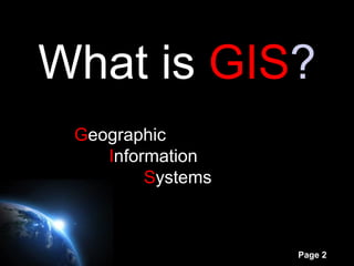
- 2. What is GIS? Geographic Information Systems Page 2
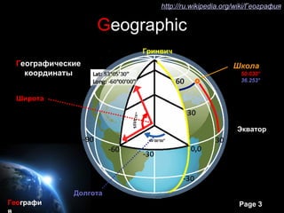
- 3. ≥у≥ў≥ў±и://∞щ≥№.Ј…Њ±∞мЊ±±и±рїеЊ±≤є.і«∞щ≤µ/Ј…Њ±∞мЊ±/–У–µ–Њ–≥—А–∞—Д–Є—П Geographic –У—А–Є–љ–≤–Є—З –У–µ–Њ–≥—А–∞—Д–Є—З–µ—Б–Ї–Є–µ –®–Ї–Њ–ї–∞ –Ї–Њ–Њ—А–і–Є–љ–∞—В—Л 50.030¬∞ 36.253¬∞ –®–Є—А–Њ—В–∞ –≠–Ї–≤–∞—В–Њ—А –Ф–Њ–ї–≥–Њ—В–∞ –У–µ–Њ–≥—А–∞—Д–Є Page 3
- 4. –ї—О–±–∞—П –Є–љ—Д–Њ—А–Љ–∞—Ж–Є—П –Њ –њ—А–µ–і–Љ–µ—В–∞—Е –Є Information —П–≤–ї–µ–љ–Є—П—ЕвА¶ –њ–Њ—З—В–Є –≤—Б—П –Є–љ—Д–Њ—А–Љ–∞—Ж–Є—П –Є–Љ–µ–µ—В –њ—А–Є–≤—П–Ј–Ї—Г –Ї –Љ–µ—Б—В—Г вАУ –Э–∞–Ј–≤–∞–љ–Є—П: —Б–≤–Њ—С –Љ–µ—Б—В–Њ—А–∞—Б–њ–Њ–ї–Њ–ґ–µ–љ–Є–µ –Э–Њ–≤–≥–Њ—А–Њ–і—Б–Ї–∞—П, –Я–∞—А–∞–Љ–µ—В—А—Л: –Ґ–µ–Ї—Б—В—Л –Я–∞–≤–ї–Њ–≤–Ї–∞, –≤—Л—Б–Њ—В–∞, –°–∞–ї—В–Њ–≤–Ї–∞ –і–Є–∞–Љ–µ—В—А, —И–Є—А–Є–љ–∞, –У–Њ–≤–µ—А–ї–∞, –Ф–Њ–љ–µ—Ж, —Ж–≤–µ—В, –Ъ—А—Л–Љ —В–µ–Љ–њ–µ—А–∞—В—Г—А–∞, —Б–Ї–Њ—А–Њ—Б—В—МвА¶ –Ш—Б—В–Њ—З–љ–Є–Ї–Є –Є–љ—Д–Њ—А–Љ–∞—Ж–Є–Є –°—В–Њ–Є–Љ–Њ—Б—В—М —Г—Б–ї—Г–≥ –Є –Ъ–∞—А—В—Л —В–Њ–≤–∞—А–Њ–≤ –Ф–∞–љ–љ—Л–µ –і–Є—Б—В–∞–љ—Ж–Є–Њ–љ–љ–Њ–≥–Њ –Ј–Њ–љ–і–Є—А–Њ–≤–∞–љ–Є—П –§–Њ—В–Њ –Т–Є–і–µ–Њ –Ф–∞–љ–љ—Л–µ –њ–Њ–ї–µ–≤—Л—Е –Є—Б—Б–ї–µ–і–Њ–≤–∞–љ–Є–є Page 4
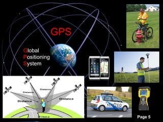
- 5. GPS Global Positioning System Page 5
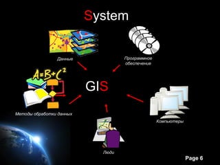
- 6. System –Ф–∞–љ–љ—Л–µ –Я—А–Њ–≥—А–∞–Љ–Љ–љ–Њ–µ –Њ–±–µ—Б–њ–µ—З–µ–љ–Є–µ GIS –У–Ш–° –Ь–µ—В–Њ–і—Л –Њ–±—А–∞–±–Њ—В–Ї–Є –і–∞–љ–љ—Л—Е –Ъ–Њ–Љ–њ—М—О—В–µ—А—Л –Ы—О–і–Є Page 6
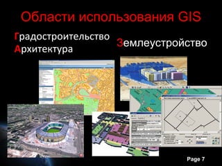
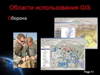
- 7. –Ю–±–ї–∞—Б—В–Є –Є—Б–њ–Њ–ї—М–Ј–Њ–≤–∞–љ–Є—П GIS –У—А–∞–і–Њ—Б—В—А–Њ–Є—В–µ–ї—М—Б—В–≤–Њ –Ч–µ–Љ–ї–µ—Г—Б—В—А–Њ–є—Б—В–≤–Њ –Р—А—Е–Є—В–µ–Ї—В—Г—А–∞ Page 7
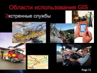
- 13. –Ю–±–ї–∞—Б—В–Є –Є—Б–њ–Њ–ї—М–Ј–Њ–≤–∞–љ–Є—П GIS –≠–Ї—Б—В—А–µ–љ–љ—Л–µ —Б–ї—Г–ґ–±—Л Page 13
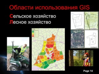
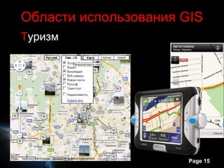
- 14. –Ю–±–ї–∞—Б—В–Є –Є—Б–њ–Њ–ї—М–Ј–Њ–≤–∞–љ–Є—П GIS –°–µ–ї—М—Б–Ї–Њ–µ —Е–Њ–Ј—П–є—Б—В–≤–Њ –Ы–µ—Б–љ–Њ–µ —Е–Њ–Ј—П–є—Б—В–≤–Њ Page 14
- 16. Page 16