introduction surveybasic-191018120837 (1).pptx
Download as PPTX, PDF0 likes31 views

introduction surveybasic-191018120837 (1).pptx


More Related Content
Similar to introduction surveybasic-191018120837 (1).pptx (20)
More from abdi beder (20)


Recently uploaded (20)


introduction surveybasic-191018120837 (1).pptx
- 2. Introduction ŌĆóDefinition: Surveying is the science and art of determining the relative positions of points above, on, or beneath the earthŌĆÖs surface and locating the points in the field.
- 3. Why Survey Surveying allows us to get accurate and valid measurements of things that are on the surface of the earth. Phases of Survey ’é¦ Field Work * Data Procurement Phase ’é¦ Office Work ’é¦ * Analysed * Reduced to useful form by mathematical calculations * Adjusted * Frequently converted to graphical mode of Expression
- 4. PRIMARY DIVISIONS OF SURVEYING 1.Plain Surveying 2.Geodetic Surveying
- 5. ŌĆó The Plain Surveying Is That Type Of Surveying In Which Earth Surface Is Considered As A Plane And The Curvature Of The Earth Is Ignored. In Such Surveying A Line Joining Any Two Stations Is Considered To Be Straight. The Triangle Formed By Any Three Points Is Considered As A Plane Triangle, And The Angles Of The Triangle Are Considered As Plain Angles. ŌĆó Surveying Is Carried Out For A Small Area Of Less Than 250 Km2 . It Is Carried Out By Local Or State Agencies Like R & B Department, Irrigation Department, Railway Department. Plain Surveying
- 7. GEODETIC SURVEYING ŌĆó The Geodetic Surveying Is That Type Of Surveying In Which The Curvature Of The Earth Is Taken Into Account. It Is Generally Extended Over Larger Areas. The Line Joining Any Two Stations Is Considered As Curved Line. The Triangle Formed By Any Three Points Is Considered To Be Spherical And The Angles Of The Triangle Are Considered To Be Spherical Angles. Geodetic Surveying Is Conducted By The Survey Of India Department And Is Carried Out For A Larger Area Exceeding 250 Km2
- 10. Difference Between Plain Surveying & Geodetic Surveying No. Plain Surveying Geodetic Surveying 1 The earth surface is considered as plain Surface. The earth surface is considered as Curved Surface. 2. The Curvature of the earth is ignored The curvature of earth is taken into account. 3 Line joining any two stations is considered to be straight The line joining any two stations is considered as spherical. 4. The triangle formed by any three points is considered as plain The Triangle formed by any three points is considered as spherical. 5. The angles of triangle are considered as plain angles. The angles of the triangle are considered as spherical angles. 6. Carried out for a small area < 250 km2 Carried out for a small area > 250 km2
- 11. CLASSIFICATION OF SURVEYING Survey can be classified into various categories depending on methods used and nature of the field, based on Purpose & Based on Instruments Classification based on Nature of field ’üČLand Survey Land Survey is done on land to prepare plan and maps of a given area. Topographical, city and cadastral surveys are some of the examples of land surveying Land Survey Maps
- 12. ’üČ Hydrological Surveying This survey is conducted on or near the body of water such as lake, river, coastal area. This Survey consists of locating shore lines of water bodies. Hydrological Maps
- 13. ’üČ Astronomical Survey This survey is conducted for the determining of latitudes, longitudes, azimuths, local time, etc. for various places on earth by observing heavenly bodies ( sun or the stars). Astronomical Survey Map
- 14. ’üČAerial Survey An aerial survey is conducted from aircraft. Aerial cameras take photographs of the surface of the earth in overlapping strips of land. This is also known as photographic survey. Aerial Survey Map
- 15. ŌĆó Classification based on Purpose ’üČGeological Survey In this both surface and subsurface surveying are conducted to locate different minerals and rocks. In addition, geological features of the terrain such as folds and faults are located. Geological Survey Map
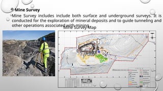
- 16. ’üČ Mine Survey Mine Survey includes include both surface and underground surveys. It is conducted for the exploration of mineral deposits and to guide tunneling and other operations associated with mining. W A S T E D U M P MN A B C D E F G H I J K L M M.L.Boundary 7.5m Safety Zone Workings Contours Nallah Canal Waste Dump Mine Approach Roads High Flood Level 456HFL Crushing & Screening Plant Core Bore Holes Statutory buildings Rope Way Line 66 K.V Power Line I N D E X PHOTOGRAPHS OF THE GROUNDCO N TRO LPO INTS CO- ORDINAT E S OF GROUNDCONTROL POINTS N 1 0┬░50'52" E076┬░49' 53" 1 0┬░50' 45" E076┬░50' 30" GCP -1 GCP-2 GCP -3 Existing Plantation Retaining Wall Water Garland Drain CHECK BUND GPS CO-ORDINATES OFBOUNDARYPOINTS N10┬░51 '08.0 0" E07 6┬░46'00.00" N1 0┬░51 '09.0 0" E076 ┬░46'40.00" N1 0┬░51 '21 .0 0" E076 ┬░46'47.00" N1 0┬░51 '21.0 0" E076 ┬░47'06.00" N1 0┬░51 '47.0 0" E076 ┬░46'22.00" LONGITUDE N1 0┬░51 '34.0 0" E076 ┬░46'06 .00" J I H G F E D C B LAT IT UDE P ILLARS A B OUNDARY N1 0┬░51 '47.0 0" E076 ┬░47'24.00" N1 0┬░51 '34.0 0" E076 ┬░45'53 .00" N1 0┬░51 '39. 00" E07 6┬░47'24.00" N1 0┬░51 '44.0 0" E076 ┬░46'06 .00" LONGITUDE LAT IT UDE P ILLARS B OUNDARY L K M N1 0┬░51 '1 3. 00" E07 6┬░46'00.00" N10┬░51 '23.0 0" E07 6┬░45'51 .00" N1 0┬░51 '1 3. 00" E07 6┬░45'48.00" G CP-1 G CP-2 G CP-3 BH-2(II) D-15 0.00 EXPLOSIVE MAGAZINE Mine Survey Map
- 17. ’üČArchaeological Survey It is conducted to locate relics of antiquity, civilization, kingdoms, forts, temples, etc. ’üČ Military Survey It has a very important and critical applications in the military. Aerial surveys are conducted for this purpose. It is conducted to locate strategic positions for the purpose of army operations. Archaeological Survey Map Military Survey Map
- 18. ’üČ Classification based on Instruments. ’üČ Chain Survey This is the simplest type of surveying in which only linear measurements are made with a chain or a tape. Angular measurements are not taken.
- 19. ’üČCompass Survey In Compass Survey, the angles are measured with the help of a magnetic compass
- 20. ’üČChain and compass survey: In this survey linear measurements are made with a chain or a tape and angular measurements with a compass.
- 21. ’üČPlane Table Surveying It is a graphical method of surveying in which field works and plotting both are done simultaneously.
- 22. ’üČTheodolite Survey In theodolite survey the horizontal angles are measured with the theodolite more precisely than compass and the linear measurements are made with a chain or tape
- 23. ’üČ Tachometry Survey A special type of theodolite known as tachometer is used to determine horizontal and vertical distances indirectly
- 24. ’üČLeveling Survey This type of survey is used to determine the vertical distances (elevations) and relative heights of points with the help of an instrument known as level.
- 25. ’üČPhotogrammetric Survey Photogrammetry is the science of taking measurements with the help of photographs taken by aerial camera from the air craft.
- 26. ’üČ EDM (Electronic Distance Measurement) Survey In this type of survey all measurements ( length, angles, co-ordinates) are made with the help of EDM instrument ( i.e.. Total Station).
- 27. ’üČ GPS (Global Positioning Systems) Survey GPS was rapidly adapted for surveying, as it can give a position (Latitude, Longitude and Height) directly, without the need to measure angles and distances between intermediate points. Survey control could now be established almost anywhere and it was only necessary to have a clear view of the sky so the signal from the GPS satellites could be received clearly.
- 28. DGPS (Differential Global Positioning Systems) Survey This Type of Surveys Which Are Carried Out Using The Differential GPS. It Achieves Higher Positional Accuracy By Making Use Of The Differential Capabilities Of Two Or More GPS Antenna Linked By A Radio Signal.
- 29. ’üČClassification Based on methods. ’üČ Triangulation Triangulation is basic method of surveying, when the area to be surveyed is large, triangulation is adopted. The entire area is divided into network of triangles.
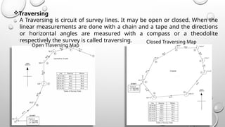
- 30. ’üČTraversing A Traversing is circuit of survey lines. It may be open or closed. When the linear measurements are done with a chain and a tape and the directions or horizontal angles are measured with a compass or a theodolite respectively the survey is called traversing. Open Traversing Map Closed Traversing Map
- 31. Thank you By D.Hussain Basha