ÃNCEL AKADEMÄḞ: AKADEMÄḞK ÄḞNGÄḞLÄḞZCE
Download as pptx, pdf0 likes301 views

Akademik ÄḞngilizce
1 of 1
Download to read offline
Recommended

Seminer poster sunumu
Seminer poster sunumuSelcen Zehra Åeker
Ìý
ultrases yöntemi hem kolay hem ucuz hemde zaman bakÄḟmÄḟndan oldukça elveriÅli bir yöntem oldugundan dolayÄḟ karot alma iÅlemine son verilip gÃỳvenilirliÄi kanÄḟtlanmÄḟÅ olan ultrasonik yöntemin kullanÄḟlmasÄḟ dilegiyleYÃỳksek lisans poster seminerleri
YÃỳksek lisans poster seminerleriAli Osman Ãncel
Ìý
Poster sunumlarÄḟ akademik kariyerin baÅÄḟnda olan yeni genç meslektaÅlarÄḟmÄḟz için en önemli kazanÄḟlmasÄḟ gereken tecrÃỳbelerden biridir. Bu nedenle, yÃỳrÃỳtÃỳcÃỳsÃỳ olduÄum MÃỳhendislik Bilimleri YÃỳksek Lisans Seminerleri MÃỳhendislik FakÃỳltesi tarihinde ilk defa herkese açÄḟk Åekilde POSTER dÃỳzeyinde yapÄḟlmasÄḟ baÅarÄḟyla gerçekleÅtirilmiÅtir. UmarÄḟm YÃỳksek Lisans EÄitiminde verilen tÃỳm SEMÄḞNERLER, ilk defa uygulandÄḟÄÄḟ Åekliyle benzer formatta sektöre, öÄrencilere ve tÃỳm profesyonellere açÄḟk yaptÄḟrÄḟlÄḟr, ve bu Åekilde Sektör-Ãniversite ve Sektör-Akademisyen buluÅmasÄḟ saÄlanarak, genç akademisyen arkadaÅlarÄḟmÄḟzÄḟn emeklerinin tabana yayÄḟlmasÄḟ saÄlanÄḟr.ÃNCEL AKADEMÄḞ: SOLID EARTH GEOPHYSICS
ÃNCEL AKADEMÄḞ: SOLID EARTH GEOPHYSICSAli Osman Ãncel
Ìý
This document discusses seismic waves and probing the Earth's interior. It provides examples of seismic wave arrival times that can be used to estimate velocities in different layers. Specifically, it examines arrival times of PcP and ScS phases to calculate mantle velocity, and uses PKiKP and PKIKP times to find velocities in the outer and inner cores. Ray tracing exercises are also presented to further analyze seismic wave propagation and velocities at different depths within the Earth.ANADOLU YAKASI GÃNEYÄḞ MÄḞKROBÃLGELEME ÃALIÅMASI
ANADOLU YAKASI GÃNEYÄḞ MÄḞKROBÃLGELEME ÃALIÅMASIAli Osman Ãncel
Ìý
DÃỳnya standarlarinda haritalar 2007 ve 2009 yÄḟllarÄḟnda ÄḞstanbul için bitirilmiÅ fakat kullanÄḟlmÄḟyor. KullanÄḟlan harita 1996 yÄḟlÄḟnda yapÄḟlmÄḟÅ ve yasal TÃỳrkiye Deprem Tehlikesi HaritasÄḟ. YÄḟllar sÃỳren çalÄḟÅma ve emek sonunda ÄḞstanbul için hazÄḟrlanan haritanÄḟn kullanÄḟlacak Åekilde yasal statÃỳ kazanmamasÄḟ, depreme dayanÄḟksÄḟz yapÄḟlaÅmaya neden oluyor. ÃeliÅkili durum dÃỳzeltilmeli.

Passive Seismology
Passive SeismologyAli Osman Ãncel
Ìý
This document discusses considerations for passive seismic acquisition based on the author's experience. It suggests that while passive seismic is gaining popularity, the equipment and understanding of practicalities may not be fully developed like they were in the early days of active 3D land seismic. The author examines important specifications for passive equipment, such as frequency response down to 1 Hz, high dynamic range, and universal applicability for both active and passive operations. Lessons from the evolution of active seismic technology are relevant to avoid potential pitfalls as passive seismic expands.
Ãncel Akademi: ÄḞstatistiksel Sismoloji
Ãncel Akademi: ÄḞstatistiksel SismolojiAli Osman Ãncel
Ìý
The document discusses issues with how the 2002 Working Group on California Earthquake Probabilities (WGCEP-2002) incorporated model uncertainty into their probabilistic seismic hazard analysis. Specifically, it critiques how WGCEP-2002 combined multiple earthquake recurrence models using a weighted averaging approach. The key issues identified are:
1) A weighted averaging approach ignores dependencies between models and can lead to biased results.
2) Choosing model weights based on data availability to systematically skew the final probability distribution.
3) The arbitrary ordering of models affects the results, which is problematic.
Alternative methods like Bayesian statistics and copulas are proposed to better account for model dependencies when incorporating model uncertainty.Ãncel Akademi: ÄḞstatistiksel Sismoloji
Ãncel Akademi: ÄḞstatistiksel SismolojiAli Osman Ãncel
Ìý
This document proposes a modification to the Gutenberg-Richter law to describe the cumulative distribution of earthquake magnitudes using concepts from nonextensive statistical mechanics. It introduces a new "q-stretched exponential" form for the modified Gutenberg-Richter law and fits this form to seismic data from California and Iran. The empirical data fits extremely well with the proposed modification over the entire range of magnitudes. Nonextensive statistical mechanics is applied to derive a q-exponential distribution for the surface size of fragments produced during earthquakes. A new hypothetical relationship is also proposed between the surface size of fragments and the released energy.ÃNCEL AKADEMÄḞ: AKADEMÄḞK
ÃNCEL AKADEMÄḞ: AKADEMÄḞKAli Osman Ãncel
Ìý
Ali Osman Oncel is a seismologist with over 20 years of experience in geophysics. He has a PhD in Geophysics from the University of Istanbul and is currently a research associate at the University of Alberta. His areas of expertise include rock physics, reservoir characterization, petrophysics, seismology, and seismic hazard analysis. He has published over 20 papers in refereed journals and conferences and taught geophysics courses for over 5 years. His research has focused on fluid effects on seismic wave propagation, seismic forecasting in Saudi Arabia, and induced stress changes from earthquakes in Canada and Turkey.

Kan bergartsfysikk og kvantitativ seismisk tolkning bidra til Ãẁkt funnrate pÃċ...
Kan bergartsfysikk og kvantitativ seismisk tolkning bidra til Ãẁkt funnrate pÃċ...geoforskning
Ìý
Rock physics provides a link between seismic data and reservoir properties by analyzing how physical rock properties affect seismic measurements. However, there are often more unknown variables than observable seismic attributes, creating a "bottleneck". Integrating rock physics with geological knowledge can help constrain non-unique interpretations. Accounting for varying rock stiffness is important, as cemented rocks may have low fluid sensitivity, making hydrocarbons difficult to detect seismically. Scale effects must also be considered, as properties vary between micro- and seismic-scales.INTRODUCTION TO ROCK PHYSICS
INTRODUCTION TO ROCK PHYSICSAli Osman Ãncel
Ìý
This document introduces rock physics concepts for interpreting seismic data. It discusses how rock physics is needed to properly interpret a seismic reflectivity map over a submarine fan. While sedimentology allows initial interpretation, well control showed clean uncemented sands had similar impedance as shales. Rock physics was needed to understand how slight cementation and poor sorting influenced impedance. The document reviews basic rock physics concepts, noting a common mistake is using overly stiff velocity-porosity relations that ignore key sedimentological variations. It introduces the concept of elastic bounds to describe effective moduli of rock mixtures.Rock Physics: Definitions
Rock Physics: DefinitionsAli Osman Ãncel
Ìý
1. The document defines key rock physics terms including density, porosity, saturation, velocity, impedance, Poisson's ratio, and reflection coefficients. Equations are provided for calculating these values from measured properties.
2. Methods of modeling reflection seismograms are described including normal reflection, reflection at an angle using Zoeppritz equations, AVO analysis, and impedance inversion.
3. Concepts of stress, strain, elasticity, elastic moduli, and their relationships to velocity are covered. The differences between static and dynamic moduli are also discussed.Rock Physics: ẃÝẃÝߣs
Rock Physics: ẃÝẃÝߣsAli Osman Ãncel
Ìý
This document discusses the rock physics of shales and source rocks. It begins by defining shale as a rock composed of mud-sized particles. Shale can have a wide range of compositions and properties depending on factors like porosity, effective stress, and organic content. The permeability of shale is very low due to its small grain size. Shale often exhibits seismic anisotropy due to thin layering of particles or organics. Organic-rich shales in particular can display large anisotropy that varies with thermal maturity. Predicting the properties of shale, especially anisotropic behavior, remains challenging due to complexity and limited data.Rock Physics: Carbonates
Rock Physics: CarbonatesAli Osman Ãncel
Ìý
The document discusses the tremendous variety of microstructures found in carbonate rocks, including granular inclusions and diverse pore shapes. This microstructural diversity leads to non-unique relationships between velocity and porosity, Vp/Vs ratios, porosity and permeability, and variations in mineral moduli. Carbonate data on plots of velocity versus porosity fall along trends that depend on factors like pore shape, mineralogy, and clay content. The document examines using well log data to infer mineral properties and the presence of minerals like calcite and dolomite in carbonate rocks. It also discusses interpreting pore shape from Vp-Vs data and the challenges in applying Gassmann fluid substitution to carbonates due to non-homogeneousÃNCEL AKADEMÄḞ: INTRODUCTION TO GEOPHYSICS
ÃNCEL AKADEMÄḞ: INTRODUCTION TO GEOPHYSICSAli Osman Ãncel
Ìý
1) The document discusses seismic reflection acquisition, processing, and waveform analysis. It covers topics like average velocity, root mean square velocity, interval velocity, and reflection and transmission coefficients.
2) Reflection coefficients are a measure of the amplitude and polarity of waves reflected from interfaces. The coefficient depends on the acoustic impedance of the layers on either side of the interface.
3) During seismic acquisition, the earth acts as a filter, convolving the source wavelet with reflection coefficients at interfaces to produce the recorded seismogram.Seismic signature of Fractures 
Seismic signature of Fractures Chonnam National University
Ìý
very nice presentation about:Rock Physics Constraints on Seismic Signatures of Fractures I hope you find it interesting

ÃNCEL AKADEMÄḞ: ÃZEL AKADEMÄḞK ÄḞNGÄḞLÄḞZCE DERSÄḞ
ÃNCEL AKADEMÄḞ: ÃZEL AKADEMÄḞK ÄḞNGÄḞLÄḞZCE DERSÄḞAli Osman Ãncel
Ìý
Ãzel Akademik ÄḞngilizce Ders


Advances in Rock Physics Modelling and Improved Estimation of CO2 Saturation,...
Advances in Rock Physics Modelling and Improved Estimation of CO2 Saturation,...UK Carbon Capture and Storage Research Centre
Ìý
Advances in Rock Physics Modelling and Improved Estimation of CO2 Saturation, Giorgos Papageorgiou - Geophysical Modelling for CO2 Storage, Leeds, 3 November 2015Topografik ve sismolojik VS30 verilerinin karÅÄḟlaÅtÄḟrÄḟlmasÄḟ; BalÄḟkesir örneÄ
Topografik ve sismolojik VS30 verilerinin karÅÄḟlaÅtÄḟrÄḟlmasÄḟ; BalÄḟkesir örneÄAli Osman Ãncel
Ìý
BalÄḟkesir merkez ilçeleri (AltÄḟeylÃỳl ve Karesi)'nde topografik verilerden elde edilen VS30 deÄeri ile jeofizik ölçÃỳmler sonucu elde edilen VS30 verileri karÅÄḟlaÅtÄḟrÄḟlarak olasÄḟ farklÄḟlÄḟklarÄḟ ve veri benzerlikleri deÄerlendirilecektir. DÃỳnya yÃỳzeyinin ÃỳstÃỳnden 30 m aÅaÄÄḟya doÄru tÃỳm tabakalarÄḟn hÄḟz bÃỳyÃỳklÃỳkleri ortalamasÄḟ olarak bulunan kayma dalgasÄḟ hÄḟzÄḟ (VS30), deprem tehlikeleri için hem öngörÃỳcÃỳ, hem de teÅhis aracÄḟ olarak yer hareketi bÃỳyÃỳtmesini tahmin etmek için anahtar bir parametredir. Topografik ve Jeofizik VS30 verileri belirli noktalarda seçilen ÄḞKÄḞ farklÄḟ yöntemle hesaplanmÄḟÅ ÄḞKÄḞ veri olarak karÅÄḟlaÅtÄḟrÄḟlÄḟp, korelasyonlarÄḟ incelenerek topografik ve sismolojik VS30 bÃỳyÃỳklÃỳklerinde fark veya benzerlik olup olmadÄḟÄÄḟ araÅtÄḟrÄḟlacaktÄḟr. Saha sismolojisi koÅullarÄḟyla ilgili bilgilerin mevcudiyeti sadece TÃỳrkiye'de sÄḟnÄḟrlÄḟ yerlerde mevcuttur. Topografik eÄim deÄiÅikliÄinden bulunan topografik VS30 bÃỳyÃỳklÃỳÄÃỳ bir araç olarak kullanÄḟlarak DÃỳnya'nÄḟn herhangi bir yerindeki sismik saha koÅullarÄḟ haritalarÄḟnÄḟ tÃỳretmek için bir metodoloji tanÄḟmlayarak, depreme baÄlÄḟ olarak olasÄḟ jeofizik risklerin ortaya çÄḟkarÄḟlmasÄḟnda hÄḟzlÄḟ bir öngörÃỳ aracÄḟ olarak kullanÄḟlabilmektedir. Topografik VS30 verileri ile bölge ÅehirleÅme amaçlÄḟ planlama projeleri kapsamÄḟnda ölçÃỳ noktalarÄḟnda tespit edilerek bulunan jeofizik VS30 verileri ile korale edilerek hÄḟzlÄḟ bir çözÃỳm aracÄḟ olarak kullanÄḟlmasÄḟ en kötÃỳ deprem riski durumunun önceden tespitinde bÃỳyÃỳk fayda saÄlayacaktÄḟr. BalÄḟkesir merkez ilçeleri (AltÄḟeylÃỳl ve Karesi)'nde yapÄḟlmÄḟÅ olan çalÄḟÅmalar sonucu elde edilen veriler ÄḟÅÄḟÄÄḟnda topografik veriler ile araziden elde edilen jeofizik veriler kullanÄḟlarak farkÄḟn deÄiÅiminin ortaya konulmasÄḟ ile deprem öncesi ve sonrasÄḟ risk verilerine hÄḟzlÄḟ ve ulaÅÄḟlabilir olmasÄḟ gerçekleÅtirilmiÅtir. Bu tez çalÄḟÅmasÄḟ kapsamÄḟnda ayrÄḟca ölçÃỳmle zaman alan iÅlemler topografik ve jeofizik veriler karÅÄḟlaÅtÄḟrÄḟlarak VS30 verilerinin ortaya konulmasÄḟ ile iyi bir referans çalÄḟÅma olmuÅtur.
More Related Content
Viewers also liked (20)
Ãncel Akademi: ÄḞstatistiksel Sismoloji
Ãncel Akademi: ÄḞstatistiksel SismolojiAli Osman Ãncel
Ìý
The document discusses issues with how the 2002 Working Group on California Earthquake Probabilities (WGCEP-2002) incorporated model uncertainty into their probabilistic seismic hazard analysis. Specifically, it critiques how WGCEP-2002 combined multiple earthquake recurrence models using a weighted averaging approach. The key issues identified are:
1) A weighted averaging approach ignores dependencies between models and can lead to biased results.
2) Choosing model weights based on data availability to systematically skew the final probability distribution.
3) The arbitrary ordering of models affects the results, which is problematic.
Alternative methods like Bayesian statistics and copulas are proposed to better account for model dependencies when incorporating model uncertainty.Ãncel Akademi: ÄḞstatistiksel Sismoloji
Ãncel Akademi: ÄḞstatistiksel SismolojiAli Osman Ãncel
Ìý
This document proposes a modification to the Gutenberg-Richter law to describe the cumulative distribution of earthquake magnitudes using concepts from nonextensive statistical mechanics. It introduces a new "q-stretched exponential" form for the modified Gutenberg-Richter law and fits this form to seismic data from California and Iran. The empirical data fits extremely well with the proposed modification over the entire range of magnitudes. Nonextensive statistical mechanics is applied to derive a q-exponential distribution for the surface size of fragments produced during earthquakes. A new hypothetical relationship is also proposed between the surface size of fragments and the released energy.ÃNCEL AKADEMÄḞ: AKADEMÄḞK
ÃNCEL AKADEMÄḞ: AKADEMÄḞKAli Osman Ãncel
Ìý
Ali Osman Oncel is a seismologist with over 20 years of experience in geophysics. He has a PhD in Geophysics from the University of Istanbul and is currently a research associate at the University of Alberta. His areas of expertise include rock physics, reservoir characterization, petrophysics, seismology, and seismic hazard analysis. He has published over 20 papers in refereed journals and conferences and taught geophysics courses for over 5 years. His research has focused on fluid effects on seismic wave propagation, seismic forecasting in Saudi Arabia, and induced stress changes from earthquakes in Canada and Turkey.Kan bergartsfysikk og kvantitativ seismisk tolkning bidra til Ãẁkt funnrate pÃċ...
Kan bergartsfysikk og kvantitativ seismisk tolkning bidra til Ãẁkt funnrate pÃċ...geoforskning
Ìý
Rock physics provides a link between seismic data and reservoir properties by analyzing how physical rock properties affect seismic measurements. However, there are often more unknown variables than observable seismic attributes, creating a "bottleneck". Integrating rock physics with geological knowledge can help constrain non-unique interpretations. Accounting for varying rock stiffness is important, as cemented rocks may have low fluid sensitivity, making hydrocarbons difficult to detect seismically. Scale effects must also be considered, as properties vary between micro- and seismic-scales.INTRODUCTION TO ROCK PHYSICS
INTRODUCTION TO ROCK PHYSICSAli Osman Ãncel
Ìý
This document introduces rock physics concepts for interpreting seismic data. It discusses how rock physics is needed to properly interpret a seismic reflectivity map over a submarine fan. While sedimentology allows initial interpretation, well control showed clean uncemented sands had similar impedance as shales. Rock physics was needed to understand how slight cementation and poor sorting influenced impedance. The document reviews basic rock physics concepts, noting a common mistake is using overly stiff velocity-porosity relations that ignore key sedimentological variations. It introduces the concept of elastic bounds to describe effective moduli of rock mixtures.Rock Physics: Definitions
Rock Physics: DefinitionsAli Osman Ãncel
Ìý
1. The document defines key rock physics terms including density, porosity, saturation, velocity, impedance, Poisson's ratio, and reflection coefficients. Equations are provided for calculating these values from measured properties.
2. Methods of modeling reflection seismograms are described including normal reflection, reflection at an angle using Zoeppritz equations, AVO analysis, and impedance inversion.
3. Concepts of stress, strain, elasticity, elastic moduli, and their relationships to velocity are covered. The differences between static and dynamic moduli are also discussed.Rock Physics: ẃÝẃÝߣs
Rock Physics: ẃÝẃÝߣsAli Osman Ãncel
Ìý
This document discusses the rock physics of shales and source rocks. It begins by defining shale as a rock composed of mud-sized particles. Shale can have a wide range of compositions and properties depending on factors like porosity, effective stress, and organic content. The permeability of shale is very low due to its small grain size. Shale often exhibits seismic anisotropy due to thin layering of particles or organics. Organic-rich shales in particular can display large anisotropy that varies with thermal maturity. Predicting the properties of shale, especially anisotropic behavior, remains challenging due to complexity and limited data.Rock Physics: Carbonates
Rock Physics: CarbonatesAli Osman Ãncel
Ìý
The document discusses the tremendous variety of microstructures found in carbonate rocks, including granular inclusions and diverse pore shapes. This microstructural diversity leads to non-unique relationships between velocity and porosity, Vp/Vs ratios, porosity and permeability, and variations in mineral moduli. Carbonate data on plots of velocity versus porosity fall along trends that depend on factors like pore shape, mineralogy, and clay content. The document examines using well log data to infer mineral properties and the presence of minerals like calcite and dolomite in carbonate rocks. It also discusses interpreting pore shape from Vp-Vs data and the challenges in applying Gassmann fluid substitution to carbonates due to non-homogeneousÃNCEL AKADEMÄḞ: INTRODUCTION TO GEOPHYSICS
ÃNCEL AKADEMÄḞ: INTRODUCTION TO GEOPHYSICSAli Osman Ãncel
Ìý
1) The document discusses seismic reflection acquisition, processing, and waveform analysis. It covers topics like average velocity, root mean square velocity, interval velocity, and reflection and transmission coefficients.
2) Reflection coefficients are a measure of the amplitude and polarity of waves reflected from interfaces. The coefficient depends on the acoustic impedance of the layers on either side of the interface.
3) During seismic acquisition, the earth acts as a filter, convolving the source wavelet with reflection coefficients at interfaces to produce the recorded seismogram.Seismic signature of Fractures
Seismic signature of Fractures Chonnam National University
Ìý
very nice presentation about:Rock Physics Constraints on Seismic Signatures of Fractures I hope you find it interestingÃNCEL AKADEMÄḞ: ÃZEL AKADEMÄḞK ÄḞNGÄḞLÄḞZCE DERSÄḞ
ÃNCEL AKADEMÄḞ: ÃZEL AKADEMÄḞK ÄḞNGÄḞLÄḞZCE DERSÄḞAli Osman Ãncel
Ìý
Ãzel Akademik ÄḞngilizce DersAdvances in Rock Physics Modelling and Improved Estimation of CO2 Saturation,...
Advances in Rock Physics Modelling and Improved Estimation of CO2 Saturation,...UK Carbon Capture and Storage Research Centre
Ìý
Advances in Rock Physics Modelling and Improved Estimation of CO2 Saturation, Giorgos Papageorgiou - Geophysical Modelling for CO2 Storage, Leeds, 3 November 2015Advances in Rock Physics Modelling and Improved Estimation of CO2 Saturation,...
Advances in Rock Physics Modelling and Improved Estimation of CO2 Saturation,...UK Carbon Capture and Storage Research Centre
Ìý
More from Ali Osman Ãncel (20)
Topografik ve sismolojik VS30 verilerinin karÅÄḟlaÅtÄḟrÄḟlmasÄḟ; BalÄḟkesir örneÄ
Topografik ve sismolojik VS30 verilerinin karÅÄḟlaÅtÄḟrÄḟlmasÄḟ; BalÄḟkesir örneÄAli Osman Ãncel
Ìý
BalÄḟkesir merkez ilçeleri (AltÄḟeylÃỳl ve Karesi)'nde topografik verilerden elde edilen VS30 deÄeri ile jeofizik ölçÃỳmler sonucu elde edilen VS30 verileri karÅÄḟlaÅtÄḟrÄḟlarak olasÄḟ farklÄḟlÄḟklarÄḟ ve veri benzerlikleri deÄerlendirilecektir. DÃỳnya yÃỳzeyinin ÃỳstÃỳnden 30 m aÅaÄÄḟya doÄru tÃỳm tabakalarÄḟn hÄḟz bÃỳyÃỳklÃỳkleri ortalamasÄḟ olarak bulunan kayma dalgasÄḟ hÄḟzÄḟ (VS30), deprem tehlikeleri için hem öngörÃỳcÃỳ, hem de teÅhis aracÄḟ olarak yer hareketi bÃỳyÃỳtmesini tahmin etmek için anahtar bir parametredir. Topografik ve Jeofizik VS30 verileri belirli noktalarda seçilen ÄḞKÄḞ farklÄḟ yöntemle hesaplanmÄḟÅ ÄḞKÄḞ veri olarak karÅÄḟlaÅtÄḟrÄḟlÄḟp, korelasyonlarÄḟ incelenerek topografik ve sismolojik VS30 bÃỳyÃỳklÃỳklerinde fark veya benzerlik olup olmadÄḟÄÄḟ araÅtÄḟrÄḟlacaktÄḟr. Saha sismolojisi koÅullarÄḟyla ilgili bilgilerin mevcudiyeti sadece TÃỳrkiye'de sÄḟnÄḟrlÄḟ yerlerde mevcuttur. Topografik eÄim deÄiÅikliÄinden bulunan topografik VS30 bÃỳyÃỳklÃỳÄÃỳ bir araç olarak kullanÄḟlarak DÃỳnya'nÄḟn herhangi bir yerindeki sismik saha koÅullarÄḟ haritalarÄḟnÄḟ tÃỳretmek için bir metodoloji tanÄḟmlayarak, depreme baÄlÄḟ olarak olasÄḟ jeofizik risklerin ortaya çÄḟkarÄḟlmasÄḟnda hÄḟzlÄḟ bir öngörÃỳ aracÄḟ olarak kullanÄḟlabilmektedir. Topografik VS30 verileri ile bölge ÅehirleÅme amaçlÄḟ planlama projeleri kapsamÄḟnda ölçÃỳ noktalarÄḟnda tespit edilerek bulunan jeofizik VS30 verileri ile korale edilerek hÄḟzlÄḟ bir çözÃỳm aracÄḟ olarak kullanÄḟlmasÄḟ en kötÃỳ deprem riski durumunun önceden tespitinde bÃỳyÃỳk fayda saÄlayacaktÄḟr. BalÄḟkesir merkez ilçeleri (AltÄḟeylÃỳl ve Karesi)'nde yapÄḟlmÄḟÅ olan çalÄḟÅmalar sonucu elde edilen veriler ÄḟÅÄḟÄÄḟnda topografik veriler ile araziden elde edilen jeofizik veriler kullanÄḟlarak farkÄḟn deÄiÅiminin ortaya konulmasÄḟ ile deprem öncesi ve sonrasÄḟ risk verilerine hÄḟzlÄḟ ve ulaÅÄḟlabilir olmasÄḟ gerçekleÅtirilmiÅtir. Bu tez çalÄḟÅmasÄḟ kapsamÄḟnda ayrÄḟca ölçÃỳmle zaman alan iÅlemler topografik ve jeofizik veriler karÅÄḟlaÅtÄḟrÄḟlarak VS30 verilerinin ortaya konulmasÄḟ ile iyi bir referans çalÄḟÅma olmuÅtur.Gravimetri : Ders 14
Gravimetri : Ders 14Ali Osman Ãncel
Ìý
Dersin Video Linkleri
https://youtu.be/BnEdQZgQJQ0
https://youtu.be/zFSW7muCDD8
Gravimetri : Ders 12
Gravimetri : Ders 12Ali Osman Ãncel
Ìý
Gravimetri Dersi için aÅaÄÄḟda ki videolarÄḟ izleyebilirsiniz.
Link 01: https://www.youtube.com/watch?v=HTyjVaVGx0k
Link 02: https://www.youtube.com/watch?v=fUkfgI8XaOE
Riskli YapÄḟlar - Ãevre ve Åehircilik
Riskli YapÄḟlar - Ãevre ve ÅehircilikAli Osman Ãncel
Ìý
Riskli YapÄḟlarla ilgili neler yapÄḟlÄḟyor?Riskli YapÄḟlar -Ãevre ve Åehircilik
Riskli YapÄḟlar -Ãevre ve ÅehircilikAli Osman Ãncel
Ìý
Riskli YapÄḟlarla ilgili çalÄḟÅmalar ne durumda?Gravimetri : Ders 07
Gravimetri : Ders 07Ali Osman Ãncel
Ìý
Ders hem yÃỳzyÃỳze sÄḟnÄḟf ortamÄḟnda hem de MsTeams Ãỳzerinden yapÄḟlmÄḟÅtÄḟr..
Gravimetri: Ders 05
Gravimetri: Ders 05Ali Osman Ãncel
Ìý
Gravimetry Ders II. ÃÄretim Ders Videosu Linki
https://youtu.be/xwNnvRLneWY
Gravimetry Ders I. ÃÄretim Ders Videosu Linki
https://youtu.be/Tb-Ka1bDuSYGravimetri : Ders 04
Gravimetri : Ders 04Ali Osman Ãncel
Ìý
The document discusses gravity anomalies and density variations in different regions based on gravity data. It shows how gravity maps reveal details about crustal thickness, tectonic features like faults and volcanic zones, and plate boundaries. Specific examples discussed include the Tibetan Plateau, Central America subduction zone, an area in Chugoku, Japan, and the state of Florida in the US. Regional gravity data can be used to model density changes associated with plate tectonics, crustal evolution, and volcanic and tectonic activity.


Kar Kar Geothermal Field Work
Kar Kar Geothermal Field WorkAli Osman Ãncel
Ìý
The USF team reviewed a geophysical investigation of the Kar Kar region conducted by WesternGeco in 2011. They found that WesternGeco's magnetotelluric (MT) data and models were of high quality. Both the WesternGeco and USF MT models identified a low resistivity zone at 300m depth that correlates with a water-bearing zone found in Borehole 4. USF performed gravity modeling which identified a north-south trending basin reaching 1500m depth, consistent with mapped faults. A preliminary hydrothermal model suggested observed temperatures could result from deep circulation of meteoric waters in the basin without needing a localized heat source. Additional geophysical data is recommended around the Jermaghbyur hot springs toBeppu geothermal field
Beppu geothermal fieldAli Osman Ãncel
Ìý
This document summarizes a study that used gravity data to delineate underground structure in the Beppu geothermal field in Japan. Analysis of Bouguer anomaly maps revealed high anomalies in the southern and northern parts of the study area that correspond to known geological formations. Edge detection filtering of the gravity data helped identify subsurface faults, including the northern edge of the high southern anomaly corresponding to the Asamigawa Fault. Depth modeling of the gravity basement showed differences between the southern and northern hot spring areas, with steep basement slopes along faults in the south and uplifted basement in the north.High Resolution Earth's Gravitational Field
High Resolution Earth's Gravitational FieldAli Osman Ãncel
Ìý
This document summarizes the development of a new ultra-high resolution model of Earth's gravity field called GGMplus. Key points:
- GGMplus combines satellite gravity data from GOCE and GRACE with terrestrial gravity data and topography to achieve unprecedented 200m spatial resolution globally.
- It provides gridded estimates of gravity, horizontal and radial field components, and quasi-geoid heights at over 3 billion points covering 80% of the Earth's land.
- GGMplus reveals new details of small-scale gravity variations and identifies locations of minimum and maximum gravity, suggesting peak-to-peak variations are 40% larger than previous estimates. The model will benefit scientific and engineering applications.Gravity Predictions for Earthquakes
Gravity Predictions for EarthquakesAli Osman Ãncel
Ìý
Gravity measurements were taken in a region of China covering the south-north earthquake belt in 1998, 2000, 2002, and 2005. Researchers noticed significant gravity changes in the region surrounding Wenchuan and suggested in 2006 that a major earthquake could occur there in 2007 or 2008. While gravity changes were significant at some locations, more research is needed to determine if they could be considered a precursor. Uncertainties exist from measurement errors, hydrologic effects, and crustal movements. Improved data collection and analysis could enhance using gravity monitoring for earthquake research.Nakamura Technique for Soil Characterization
Nakamura Technique for Soil CharacterizationAli Osman Ãncel
Ìý
Multidisipliner Jeofizik Yöntemler, deprem gÃỳvenli jeofizik 'fiziksel zeminleri' çok net ortaya çÄḟkarÄḟyor.H/V User Guidelines 
H/V User Guidelines Ali Osman Ãncel
Ìý
The document provides guidelines for implementing the H/V spectral ratio technique using ambient vibration measurements to evaluate site effects. It recommends procedures for experimental design, data processing, and interpretation. The key recommendations include measuring for sufficient duration depending on expected frequency, using multiple measurement points, avoiding disturbances, and interpreting H/V peaks in context with geological and geophysical data. Reliable H/V peaks are defined as having a clear maximum within expected frequency ranges and uncertainties. The guidelines aim to help apply the technique while accounting for its limitations.Topografik ve sismolojik VS30 verilerinin karÅÄḟlaÅtÄḟrÄḟlmasÄḟ; BalÄḟkesir örneÄ
Topografik ve sismolojik VS30 verilerinin karÅÄḟlaÅtÄḟrÄḟlmasÄḟ; BalÄḟkesir örneÄAli Osman Ãncel
Ìý
Recently uploaded (6)
Gazi Mustafa Kemal AtatÃỳrk 1st Edition ÄḞlber OrtaylÄḟ
Gazi Mustafa Kemal AtatÃỳrk 1st Edition ÄḞlber OrtaylÄḟlvgbvvbd7998
Ìý
Gazi Mustafa Kemal AtatÃỳrk 1st Edition ÄḞlber OrtaylÄḟ
Gazi Mustafa Kemal AtatÃỳrk 1st Edition ÄḞlber OrtaylÄḟ
Gazi Mustafa Kemal AtatÃỳrk 1st Edition ÄḞlber OrtaylÄḟ
50 Soruda Antropoloji 3rd Edition Sibel Ãzbudun GÃỳlfem Uysal
50 Soruda Antropoloji 3rd Edition Sibel Ãzbudun GÃỳlfem Uysalwyudmpex3786
Ìý
50 Soruda Antropoloji 3rd Edition Sibel Ãzbudun GÃỳlfem Uysal
50 Soruda Antropoloji 3rd Edition Sibel Ãzbudun GÃỳlfem Uysal
50 Soruda Antropoloji 3rd Edition Sibel Ãzbudun GÃỳlfem UysalExample of Application According to the Value Stream Costing Method in an Agr...
Example of Application According to the Value Stream Costing Method in an Agr...dmdcarssg158
Ìý
Example of Application According to the Value Stream Costing Method in an Agribusiness Producing Apple 1st Edition Ulukan Buyukarikan
Example of Application According to the Value Stream Costing Method in an Agribusiness Producing Apple 1st Edition Ulukan Buyukarikan
Example of Application According to the Value Stream Costing Method in an Agribusiness Producing Apple 1st Edition Ulukan Buyukarikan

ÃNCEL AKADEMÄḞ: AKADEMÄḞK ÄḞNGÄḞLÄḞZCE
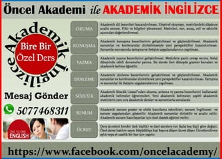
- 1. https://www.facebook.com/oncelacademy/ Ãncel Akademi ile AKADEMÄḞK ÄḞNGÄḞLÄḞZCE Mesaj Gönder 5077468311, OKUMA KONUÅMA YAZMA DÄḞNLEME SÃZCÃK SUNUM ÃCRET Akademik dil becerileri kazandÄḟrÄḟlmasÄḟ. EleÅtirel okumayÄḟ, metinlerdeki dÃỳÅÃỳnce analiz etmesi. Fikir ve bilgileri yönetmesi. Metinleri, ton, amaç, stil ve etkinlik açÄḟsÄḟndan deÄerlendirmesi. Ders Ãỳcretleri birebir (tek kiÅilik) ve özel derslere (en fazla beÅ kiÅi) göre deÄiÅir. Ãzel derse katÄḟlÄḟm sayÄḟsÄḟ bÃỳyÃỳdÃỳkçe kiÅi baÅÄḟna dÃỳÅen Ãỳcret dÃỳÅer. Ãcretlendirme aylÄḟk veya 16 saatlik bir kur için yapÄḟlÄḟr. Akademik konuÅma becerilerinin geliÅtirilmesi ve gÃỳçlendirilmesi. Akademik sunumlar ve konferanslar dinletilmesiyle yeni perspektifler kazandÄḟrÄḟlmasÄḟ. Sunumlar sonrasÄḟnda tartÄḟÅma ve iletiÅim uygulamalarÄḟnÄḟn yapÄḟlmasÄḟ. Akademik yazma becerilerini geliÅtirilmesi. Metinlere yazÄḟlÄḟ cevap verme. Kolej dÃỳzeyinde etkili denemeler yazma. Bu derste ileri dÃỳzeyde gramer konularÄḟ ve akademik kelime öÄretilir. Akademik dinleme becerilerinin geliÅtirilmesi ve gÃỳçlendirilmesi. Akademik sunumlar ve konferanslar dinletilerek yeni perspektifler kazandÄḟrÄḟlmasÄḟ. TartÄḟÅma ve sunumlar ile iletiÅim uygulamalarÄḟnÄḟn yapÄḟlmasÄḟ. Akademik SözcÃỳk Listesi"nden okuma, anlama ve yazma becerilerini kullanarak akademik kelimeler öÄrenmeleri. Yeni akademik kelimeler, çeÅitli akademik metinlerin yanÄḟ sÄḟra akademik dersler ve sunumlarla sunulacak. Akademik sunum poster ve sözlÃỳ hazÄḟrlama teknikleri, sunum ÄḞngilizcesi ve sunum uygulamalarÄḟ gösterilir. Akademik sunumlar dinletilir ve analiz edilir. Akademik sunum hazÄḟrlayanlar için özel destek eÄitimi verilir.