ºÝºÝߣ

ºÝºÝߣShare a Scribd company logo
The Ocean Floor
Sonar Part 1
Sonar Sonar- Stands for   so und   na vigation and   r anging Sonar was first developed by British naval scientists in 1921.  Later it was used in times of warfare. More commonly sonar is used to measure the distance from the ocean’s surface to the bottom. Sonar has also been used on land.  Pulses sent through soil can identify different layers of soil and rock as well as locate natural gas and oil!
How does it work? A sonar device emits sound waves into the ocean from the surface.  When the impulses strike the bottom they return to the ship carrying the sonar device in the form of an echo. It then computes the depth of the ocean at that point.  The longer it takes for the echo to return the deeper the ocean floor is!
Do the Math! Scientists know that sound waves travel through the water at 1,530m/s. If it takes an impulse 6.60s to travel from the ship to the ocean floor and back again, how deep is that part of the ocean?
Answer 1,530 m/s X6.60 s 10,098 m 10,098 m 2 = 5,049 m
Mapping Sonar has allowed scientists to accurately map the ocean floor.  As a result many interesting discoveries have been made.  Including abysses 10,600 m deep (6.3 miles), and mountains higher than Mt Everest the tallest mountain on land at 8,848m (29,198 ft).

More Related Content

What's hot (9)

Oceans
OceansOceans
Oceans
somethinglikethat
Ìý
Sonar
SonarSonar
Sonar
Ruary1
Ìý
coastal studies
coastal studiescoastal studies
coastal studies
MsGeo
Ìý
Tsunami
TsunamiTsunami
Tsunami
Moses Lutta
Ìý
Oceans
OceansOceans
Oceans
wafa786
Ìý
Introduce the zones
Introduce the zonesIntroduce the zones
Introduce the zones
Kelly Neal
Ìý
Earth presentation
Earth presentationEarth presentation
Earth presentation
Educational Learner
Ìý
Geo science lecture 4
Geo science lecture 4Geo science lecture 4
Geo science lecture 4
Zemran Ali Khan
Ìý
Explosive and non explosive energy sources in marine acquisition ( overview )
Explosive and non explosive energy sources in marine acquisition ( overview )Explosive and non explosive energy sources in marine acquisition ( overview )
Explosive and non explosive energy sources in marine acquisition ( overview )
Ali M. Abdelsamad
Ìý
Sonar
SonarSonar
Sonar
Ruary1
Ìý
coastal studies
coastal studiescoastal studies
coastal studies
MsGeo
Ìý
Oceans
OceansOceans
Oceans
wafa786
Ìý
Introduce the zones
Introduce the zonesIntroduce the zones
Introduce the zones
Kelly Neal
Ìý
Geo science lecture 4
Geo science lecture 4Geo science lecture 4
Geo science lecture 4
Zemran Ali Khan
Ìý
Explosive and non explosive energy sources in marine acquisition ( overview )
Explosive and non explosive energy sources in marine acquisition ( overview )Explosive and non explosive energy sources in marine acquisition ( overview )
Explosive and non explosive energy sources in marine acquisition ( overview )
Ali M. Abdelsamad
Ìý

Similar to Ocean floor (20)

sonar
sonarsonar
sonar
jhcid
Ìý
Sofar channel
Sofar channelSofar channel
Sofar channel
rebelbrindley
Ìý
The sound fixing and ranging layer in the ocean, or theÌýSOFARÌých.docx
The sound fixing and ranging layer in the ocean, or theÌýSOFARÌých.docxThe sound fixing and ranging layer in the ocean, or theÌýSOFARÌých.docx
The sound fixing and ranging layer in the ocean, or theÌýSOFARÌých.docx
suzannewarch
Ìý
Sonar
SonarSonar
Sonar
PPThelperkid
Ìý
SONAR ppt
SONAR ppt SONAR ppt
SONAR ppt
Ks Maheta
Ìý
Sonar.pptx
Sonar.pptxSonar.pptx
Sonar.pptx
Urvi Patel
Ìý
Plate Tectonics 10.2 08 09
Plate Tectonics 10.2 08 09Plate Tectonics 10.2 08 09
Plate Tectonics 10.2 08 09
davedelg1
Ìý
Ch 7-2 pp.ppt
Ch 7-2 pp.pptCh 7-2 pp.ppt
Ch 7-2 pp.ppt
yuridanggo
Ìý
P. sai srikar ppt on sonar applications
P. sai srikar ppt on sonar  applicationsP. sai srikar ppt on sonar  applications
P. sai srikar ppt on sonar applications
9948879993
Ìý
continental-drift-and-seafloor-spreading.pptx
continental-drift-and-seafloor-spreading.pptxcontinental-drift-and-seafloor-spreading.pptx
continental-drift-and-seafloor-spreading.pptx
thegamerdog123456795
Ìý
bathymetry introduction (Philippine fishing grounds).pptx
bathymetry introduction (Philippine fishing grounds).pptxbathymetry introduction (Philippine fishing grounds).pptx
bathymetry introduction (Philippine fishing grounds).pptx
Ex Jay Moran
Ìý
Oceanography instruments used in fishing Activities
Oceanography instruments used in fishing ActivitiesOceanography instruments used in fishing Activities
Oceanography instruments used in fishing Activities
Dr. Sudesh D. Rathod, B N Bandodkar College of Science
Ìý
Sidescan sonar (nio)
Sidescan sonar (nio)Sidescan sonar (nio)
Sidescan sonar (nio)
Sabna Thilakan
Ìý
Sound 2
Sound 2Sound 2
Sound 2
Swetha Ravichandran
Ìý
seafloorspreading-200430053459.pdf
seafloorspreading-200430053459.pdfseafloorspreading-200430053459.pdf
seafloorspreading-200430053459.pdf
yuridanggo
Ìý
Sea floor spreading2
Sea floor spreading2Sea floor spreading2
Sea floor spreading2
Cindy Claire Sevilla
Ìý
Seafloor Spreading
Seafloor SpreadingSeafloor Spreading
Seafloor Spreading
Simple ABbieC
Ìý
Presentation of Introduction to basics of SONAR.pptx
Presentation of Introduction to basics of SONAR.pptxPresentation of Introduction to basics of SONAR.pptx
Presentation of Introduction to basics of SONAR.pptx
asadmohammedjmu
Ìý
Acoustic imaging of the sea floor
Acoustic imaging of the sea floorAcoustic imaging of the sea floor
Acoustic imaging of the sea floor
Rico Chirana
Ìý
Studying the sea floor
Studying the sea floorStudying the sea floor
Studying the sea floor
Via Martinez Abayon
Ìý
sonar
sonarsonar
sonar
jhcid
Ìý
The sound fixing and ranging layer in the ocean, or theÌýSOFARÌých.docx
The sound fixing and ranging layer in the ocean, or theÌýSOFARÌých.docxThe sound fixing and ranging layer in the ocean, or theÌýSOFARÌých.docx
The sound fixing and ranging layer in the ocean, or theÌýSOFARÌých.docx
suzannewarch
Ìý
SONAR ppt
SONAR ppt SONAR ppt
SONAR ppt
Ks Maheta
Ìý
Sonar.pptx
Sonar.pptxSonar.pptx
Sonar.pptx
Urvi Patel
Ìý
Plate Tectonics 10.2 08 09
Plate Tectonics 10.2 08 09Plate Tectonics 10.2 08 09
Plate Tectonics 10.2 08 09
davedelg1
Ìý
Ch 7-2 pp.ppt
Ch 7-2 pp.pptCh 7-2 pp.ppt
Ch 7-2 pp.ppt
yuridanggo
Ìý
P. sai srikar ppt on sonar applications
P. sai srikar ppt on sonar  applicationsP. sai srikar ppt on sonar  applications
P. sai srikar ppt on sonar applications
9948879993
Ìý
continental-drift-and-seafloor-spreading.pptx
continental-drift-and-seafloor-spreading.pptxcontinental-drift-and-seafloor-spreading.pptx
continental-drift-and-seafloor-spreading.pptx
thegamerdog123456795
Ìý
bathymetry introduction (Philippine fishing grounds).pptx
bathymetry introduction (Philippine fishing grounds).pptxbathymetry introduction (Philippine fishing grounds).pptx
bathymetry introduction (Philippine fishing grounds).pptx
Ex Jay Moran
Ìý
Sidescan sonar (nio)
Sidescan sonar (nio)Sidescan sonar (nio)
Sidescan sonar (nio)
Sabna Thilakan
Ìý
seafloorspreading-200430053459.pdf
seafloorspreading-200430053459.pdfseafloorspreading-200430053459.pdf
seafloorspreading-200430053459.pdf
yuridanggo
Ìý
Seafloor Spreading
Seafloor SpreadingSeafloor Spreading
Seafloor Spreading
Simple ABbieC
Ìý
Presentation of Introduction to basics of SONAR.pptx
Presentation of Introduction to basics of SONAR.pptxPresentation of Introduction to basics of SONAR.pptx
Presentation of Introduction to basics of SONAR.pptx
asadmohammedjmu
Ìý
Acoustic imaging of the sea floor
Acoustic imaging of the sea floorAcoustic imaging of the sea floor
Acoustic imaging of the sea floor
Rico Chirana
Ìý

More from ECSD (9)

How to write a 5 paragraph essay
How to write a 5 paragraph essayHow to write a 5 paragraph essay
How to write a 5 paragraph essay
ECSD
Ìý
How to write a 5 paragraph essay
How to write a 5 paragraph essayHow to write a 5 paragraph essay
How to write a 5 paragraph essay
ECSD
Ìý
Open house
Open houseOpen house
Open house
ECSD
Ìý
Cell processes
Cell processesCell processes
Cell processes
ECSD
Ìý
Animal and Plant Cells
Animal and Plant CellsAnimal and Plant Cells
Animal and Plant Cells
ECSD
Ìý
Earth’s magnetism
Earth’s magnetismEarth’s magnetism
Earth’s magnetism
ECSD
Ìý
Ocean floor
Ocean floorOcean floor
Ocean floor
ECSD
Ìý
Protists
ProtistsProtists
Protists
ECSD
Ìý
Moneran Kingdom
Moneran KingdomMoneran Kingdom
Moneran Kingdom
ECSD
Ìý
How to write a 5 paragraph essay
How to write a 5 paragraph essayHow to write a 5 paragraph essay
How to write a 5 paragraph essay
ECSD
Ìý
How to write a 5 paragraph essay
How to write a 5 paragraph essayHow to write a 5 paragraph essay
How to write a 5 paragraph essay
ECSD
Ìý
Open house
Open houseOpen house
Open house
ECSD
Ìý
Cell processes
Cell processesCell processes
Cell processes
ECSD
Ìý
Animal and Plant Cells
Animal and Plant CellsAnimal and Plant Cells
Animal and Plant Cells
ECSD
Ìý
Earth’s magnetism
Earth’s magnetismEarth’s magnetism
Earth’s magnetism
ECSD
Ìý
Ocean floor
Ocean floorOcean floor
Ocean floor
ECSD
Ìý
Protists
ProtistsProtists
Protists
ECSD
Ìý
Moneran Kingdom
Moneran KingdomMoneran Kingdom
Moneran Kingdom
ECSD
Ìý

Ocean floor

  • 3. Sonar Sonar- Stands for so und na vigation and r anging Sonar was first developed by British naval scientists in 1921. Later it was used in times of warfare. More commonly sonar is used to measure the distance from the ocean’s surface to the bottom. Sonar has also been used on land. Pulses sent through soil can identify different layers of soil and rock as well as locate natural gas and oil!
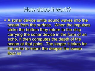
  • 4. How does it work? A sonar device emits sound waves into the ocean from the surface. When the impulses strike the bottom they return to the ship carrying the sonar device in the form of an echo. It then computes the depth of the ocean at that point. The longer it takes for the echo to return the deeper the ocean floor is!
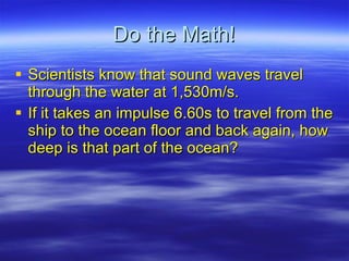
  • 5. Do the Math! Scientists know that sound waves travel through the water at 1,530m/s. If it takes an impulse 6.60s to travel from the ship to the ocean floor and back again, how deep is that part of the ocean?
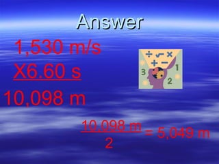
  • 6. Answer 1,530 m/s X6.60 s 10,098 m 10,098 m 2 = 5,049 m
  • 7. Mapping Sonar has allowed scientists to accurately map the ocean floor. As a result many interesting discoveries have been made. Including abysses 10,600 m deep (6.3 miles), and mountains higher than Mt Everest the tallest mountain on land at 8,848m (29,198 ft).