際際滷

際際滷Share a Scribd company logo
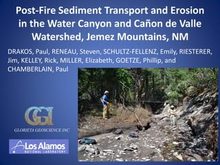
Post-Fire Sediment Transport and Erosion
  in the Water Canyon and Ca単on de Valle
      Watershed, Jemez Mountains, NM
DRAKOS, Paul, RENEAU, Steven, SCHULTZ-FELLENZ, Emily, RIESTERER,
Jim, KELLEY, Rick, MILLER, Elizabeth, GOETZE, Phillip, and
CHAMBERLAIN, Paul


  GLORIETA GEOSCIENCE INC
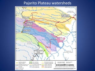
Pajarito Plateau watersheds
Water Canyon/Ca単on de Valle investigation
    conducted 2010-2011 to assess contaminant
         inventory in post-1942 sediments
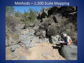
    1:200 scale mapping in 25+ reaches
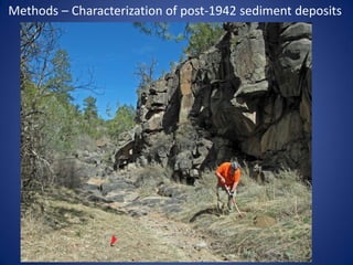
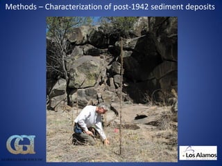
    Characterization of post-1942 sediments using hand-dug pot
     holes (identified based on presence of exotic clasts, buried
     soils, bedrock, etc.)
    Dendrochronology utilized to provided supplemental
     information to constrain the age of flood deposits
    Reworked ash from 1977 La Mesa fire and 2000 Cerro
     Grande fire preserved in situ within sediment deposits
     provides additional age control
    Measurement of cross sections following post-fire floods on
     8/3/11 and 8/21/11
    8/21/11 flood est. ~3000 cfs in CDV, larger than 8/3/11 flood


                                                  GLORIETA GEOSCIENCE INC
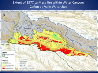
Extent of 1977 La Mesa fire within Water Canyon/
            Ca単on de Valle Watershed
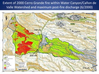
Extent of 2000 Cerro Grande fire within Water Canyon/Ca単on de
  Valle Watershed and maximum post-fire discharge (6/2000)


                     740 cfs


                 840 cfs


                                                    274 cfs
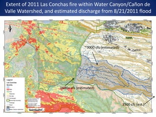
Extent of 2011 Las Conchas fire within Water Canyon/Ca単on de
Valle Watershed, and estimated discharge from 8/21/2011 flood


                                      ~3000 cfs (estimated)


                       1600+ cfs (estimated)


                                                              3500 cfs (est.)
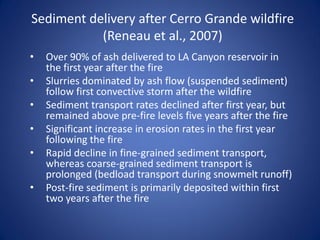
Sediment delivery after Cerro Grande wildfire
           (Reneau et al., 2007)
   Over 90% of ash delivered to LA Canyon reservoir in
    the first year after the fire
   Slurries dominated by ash flow (suspended sediment)
    follow first convective storm after the wildfire
   Sediment transport rates declined after first year, but
    remained above pre-fire levels five years after the fire
   Significant increase in erosion rates in the first year
    following the fire
   Rapid decline in fine-grained sediment transport,
    whereas coarse-grained sediment transport is
    prolonged (bedload transport during snowmelt runoff)
   Post-fire sediment is primarily deposited within first
    two years after the fire
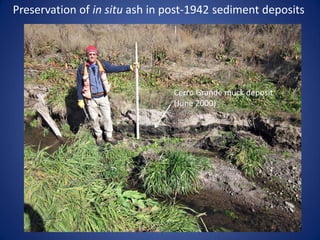
Preservation of in situ ash in post-1942 sediment deposits


                                Cerro Grande muck deposit
                                (June 2000)
Methods  1:200 Scale Mapping
Methods  Characterization of post-1942 sediment deposits


GLORIETA GEOSCIENCE INC
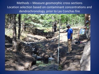
Methods  Measure geomorphic cross sections
Location selection based on contaminant concentrations and
        dendrochronology, prior to Las Conchas fire
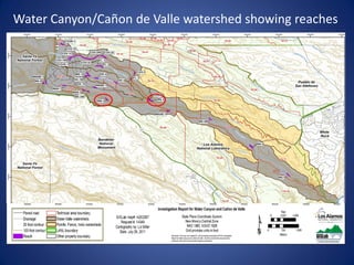
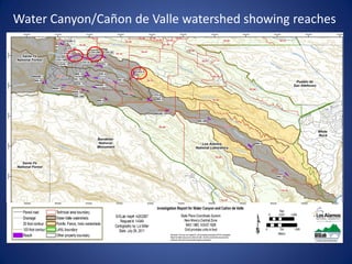
Water Canyon/Ca単on de Valle watershed showing reaches
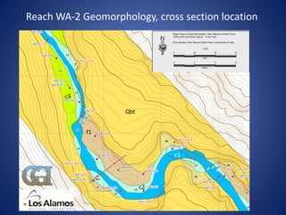
Reach WA-2 Geomorphology, cross section location


        c3

                    Qbt


             f1


                               c1


                          c2
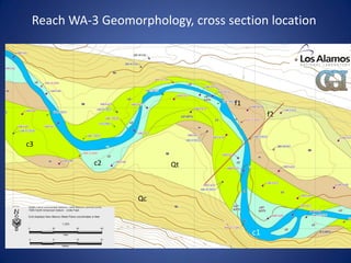
Reach WA-3 Geomorphology, cross section location


                                        f1
                                                  f2


     c3

                c2           Qt


                       Qc


c1
                                             c1
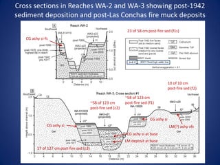
Cross sections in Reaches WA-2 and WA-3 showing post-1942
sediment deposition and post-Las Conchas fire muck deposits
                                                                 23 of 58 cm post-fire sed (f1s)
   CG ashy si-fs


                                                                                            10 of 10 cm
                                                                                            post-fire sed (f2)

                                                                ~58 of 123 cm
                                           ~58 of 123 cm        post-fire sed (f1)
                                           post-fire sed (c2)

                                                                               CG ashy si
               CG ashy si                                                                   LM(?) ashy vfs
                                                                 CG ashy si at base
                                                                LM deposit at base
         17 of 127 cm post-fire sed (c3)
Water Canyon/Ca単on de Valle watershed showing reaches
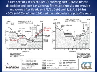
Cross sections in Reach CDV-1E showing post-1942 sediment
deposition and post-Las Conchas fire muck deposits and erosion
   measured after floods on 8/3/11 (left) and 8/21/11 (right)
> 50% (+/-75%) of post 1942 sediment deposits are post-fire seds


                            CG muck
                            at base


   CG ashy si
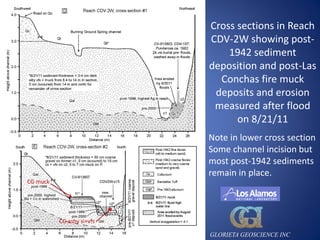
Cross sections in Reach
                           CDV-2W showing post-
                               1942 sediment
                           deposition and post-Las
                             Conchas fire muck
                            deposits and erosion
                            measured after flood
                                 on 8/21/11
                           Note in lower cross section
                           Some channel incision but
                           most post-1942 sediments
                           remain in place.
CG muck


          CG ashy si+vfs

                           GLORIETA GEOSCIENCE INC
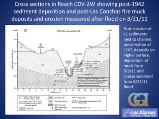
Cross sections in Reach CDV-2W showing post-1942
 sediment deposition and post-Las Conchas fire muck
deposits and erosion measured after flood on 8/21/11
                                          Note erosion of
                                          c2 sediments
                                          next to channel,
                                          preservation of
                                          c3/f1 deposits on
                                          higher surface,
                                          deposition of
                                          muck from
                                          8/3/11 and
                                          coarse sediment
                                          from 8/21/11
                                          flood.
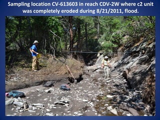
Sampling location CV-613603 in reach CDV-2W where c2 unit
     was completely eroded during 8/21/2011, flood.
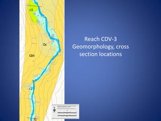
c3


               c1       Reach CDV-3
          Qc
                    Geomorphology, cross
Qbt                   section locations


c2


     f1
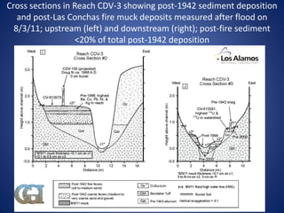
Cross sections in Reach CDV-3 showing post-1942 sediment deposition
   and post-Las Conchas fire muck deposits measured after flood on
  8/3/11; upstream (left) and downstream (right); post-fire sediment
                  <20% of total post-1942 deposition
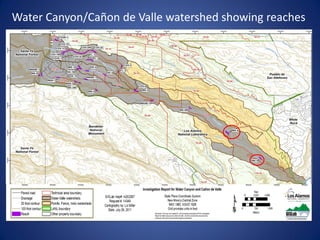
Water Canyon/Ca単on de Valle watershed showing reaches
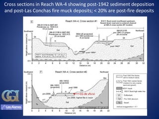
Cross sections in Reach WA-4 showing post-1942 sediment deposition
and post-Las Conchas fire muck deposits; < 20% are post-fire deposits


                                  CG dk vfs+si
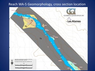
Reach WA-5 Geomorphology, cross section location

                                  GLORIETA GEOSCIENCE INC
               c2
                    f1
                         c1
          Qc


                          Tb


                                       c1
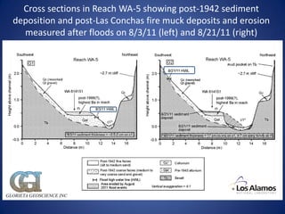
Cross sections in Reach WA-5 showing post-1942 sediment
  deposition and post-Las Conchas fire muck deposits and erosion
    measured after floods on 8/3/11 (left) and 8/21/11 (right)


GLORIETA GEOSCIENCE INC
8/23/11 Flood coarse sediment
    deposits and scouring
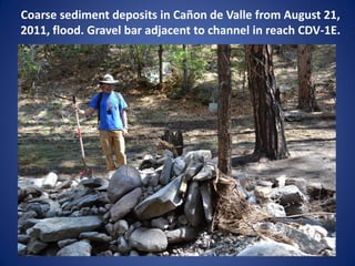
Coarse sediment deposits in Ca単on de Valle from August 21,
2011, flood. Gravel bar adjacent to channel in reach CDV-1E.
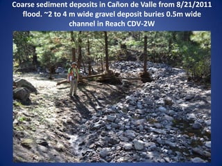
Coarse sediment deposits in Ca単on de Valle from 8/21/2011
   flood. ~2 to 4 m wide gravel deposit buries 0.5m wide
                  channel in Reach CDV-2W
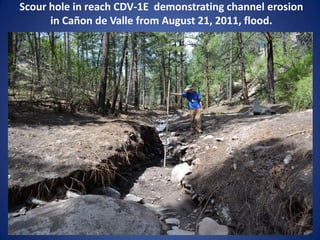
Scour hole in reach CDV-1E demonstrating channel erosion
      in Ca単on de Valle from August 21, 2011, flood.
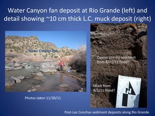
Water Canyon fan deposit at Rio Grande (left) and
detail showing ~10 cm thick L.C. muck deposit (right)


         Water Canyon Fan
                                                  Coarse (ms-cs) sediment
                                                  from 8/21/11 flood?


                                                Muck from
                                                8/3/11 flood?
       Photos taken 11/30/11


                               Post-Las Conchas sediment deposits along Rio Grande
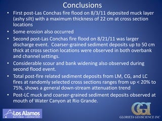
Conclusions
 First post-Las Conchas fire flood on 8/3/11 deposited muck layer
  (ashy silt) with a maximum thickness of 22 cm at cross section
  locations
 Some erosion also occurred
 Second post-Las Conchas fire flood on 8/21/11 was larger
  discharge event. Coarser-grained sediment deposits up to 50 cm
  thick at cross section locations were observed in both overbank
  and channel settings.
 Considerable scour and bank widening also observed during
  second flood event.
 Total post-fire related sediment deposits from LM, CG, and LC
  fires at randomly selected cross sections ranges from up < 20% to
  75%, shows a general down-stream attenuation trend
 Post-LC muck and coarser-grained sediment deposits observed at
  mouth of Water Canyon at Rio Grande.

                                                  GLORIETA GEOSCIENCE INC
Pending Investigation (2012)


 Systematic assessment of post-Las Conchas erosion and
  deposition in reaches investigated in 2010/2011
 Reoccupy and resurvey cross sections to quantify post-Las
  Conchas fire erosion and deposition at specific locations


                                                 GLORIETA GEOSCIENCE INC
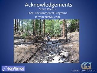
Acknowledgements
        Steve Veenis
LANL Environmental Programs
     TerranearPMC.com


                              GLORIETA GEOSCIENCE INC

More Related Content

Post-Fire Sediment Transport and Erosion in the Water Canyon and Canon de Valle Watershed, Jamez Mountains, NM

  • 1. Post-Fire Sediment Transport and Erosion in the Water Canyon and Ca単on de Valle Watershed, Jemez Mountains, NM DRAKOS, Paul, RENEAU, Steven, SCHULTZ-FELLENZ, Emily, RIESTERER, Jim, KELLEY, Rick, MILLER, Elizabeth, GOETZE, Phillip, and CHAMBERLAIN, Paul GLORIETA GEOSCIENCE INC
  • 3. Water Canyon/Ca単on de Valle investigation conducted 2010-2011 to assess contaminant inventory in post-1942 sediments 1:200 scale mapping in 25+ reaches Characterization of post-1942 sediments using hand-dug pot holes (identified based on presence of exotic clasts, buried soils, bedrock, etc.) Dendrochronology utilized to provided supplemental information to constrain the age of flood deposits Reworked ash from 1977 La Mesa fire and 2000 Cerro Grande fire preserved in situ within sediment deposits provides additional age control Measurement of cross sections following post-fire floods on 8/3/11 and 8/21/11 8/21/11 flood est. ~3000 cfs in CDV, larger than 8/3/11 flood GLORIETA GEOSCIENCE INC
  • 4. Extent of 1977 La Mesa fire within Water Canyon/ Ca単on de Valle Watershed
  • 5. Extent of 2000 Cerro Grande fire within Water Canyon/Ca単on de Valle Watershed and maximum post-fire discharge (6/2000) 740 cfs 840 cfs 274 cfs
  • 6. Extent of 2011 Las Conchas fire within Water Canyon/Ca単on de Valle Watershed, and estimated discharge from 8/21/2011 flood ~3000 cfs (estimated) 1600+ cfs (estimated) 3500 cfs (est.)
  • 7. Sediment delivery after Cerro Grande wildfire (Reneau et al., 2007) Over 90% of ash delivered to LA Canyon reservoir in the first year after the fire Slurries dominated by ash flow (suspended sediment) follow first convective storm after the wildfire Sediment transport rates declined after first year, but remained above pre-fire levels five years after the fire Significant increase in erosion rates in the first year following the fire Rapid decline in fine-grained sediment transport, whereas coarse-grained sediment transport is prolonged (bedload transport during snowmelt runoff) Post-fire sediment is primarily deposited within first two years after the fire
  • 8. Preservation of in situ ash in post-1942 sediment deposits Cerro Grande muck deposit (June 2000)
  • 9. Methods 1:200 Scale Mapping
  • 10. Methods Characterization of post-1942 sediment deposits
  • 11. Methods Characterization of post-1942 sediment deposits GLORIETA GEOSCIENCE INC
  • 12. Methods Measure geomorphic cross sections Location selection based on contaminant concentrations and dendrochronology, prior to Las Conchas fire
  • 13. Water Canyon/Ca単on de Valle watershed showing reaches
  • 14. Reach WA-2 Geomorphology, cross section location c3 Qbt f1 c1 c2
  • 15. Reach WA-3 Geomorphology, cross section location f1 f2 c3 c2 Qt Qc c1 c1
  • 16. Cross sections in Reaches WA-2 and WA-3 showing post-1942 sediment deposition and post-Las Conchas fire muck deposits 23 of 58 cm post-fire sed (f1s) CG ashy si-fs 10 of 10 cm post-fire sed (f2) ~58 of 123 cm ~58 of 123 cm post-fire sed (f1) post-fire sed (c2) CG ashy si CG ashy si LM(?) ashy vfs CG ashy si at base LM deposit at base 17 of 127 cm post-fire sed (c3)
  • 17. Water Canyon/Ca単on de Valle watershed showing reaches
  • 18. Cross sections in Reach CDV-1E showing post-1942 sediment deposition and post-Las Conchas fire muck deposits and erosion measured after floods on 8/3/11 (left) and 8/21/11 (right) > 50% (+/-75%) of post 1942 sediment deposits are post-fire seds CG muck at base CG ashy si
  • 19. Cross sections in Reach CDV-2W showing post- 1942 sediment deposition and post-Las Conchas fire muck deposits and erosion measured after flood on 8/21/11 Note in lower cross section Some channel incision but most post-1942 sediments remain in place. CG muck CG ashy si+vfs GLORIETA GEOSCIENCE INC
  • 20. Cross sections in Reach CDV-2W showing post-1942 sediment deposition and post-Las Conchas fire muck deposits and erosion measured after flood on 8/21/11 Note erosion of c2 sediments next to channel, preservation of c3/f1 deposits on higher surface, deposition of muck from 8/3/11 and coarse sediment from 8/21/11 flood.
  • 21. Sampling location CV-613603 in reach CDV-2W where c2 unit was completely eroded during 8/21/2011, flood.
  • 22. c3 c1 Reach CDV-3 Qc Geomorphology, cross Qbt section locations c2 f1
  • 23. Cross sections in Reach CDV-3 showing post-1942 sediment deposition and post-Las Conchas fire muck deposits measured after flood on 8/3/11; upstream (left) and downstream (right); post-fire sediment <20% of total post-1942 deposition
  • 24. Water Canyon/Ca単on de Valle watershed showing reaches
  • 25. Cross sections in Reach WA-4 showing post-1942 sediment deposition and post-Las Conchas fire muck deposits; < 20% are post-fire deposits CG dk vfs+si
  • 26. Reach WA-5 Geomorphology, cross section location GLORIETA GEOSCIENCE INC c2 f1 c1 Qc Tb c1
  • 27. Cross sections in Reach WA-5 showing post-1942 sediment deposition and post-Las Conchas fire muck deposits and erosion measured after floods on 8/3/11 (left) and 8/21/11 (right) GLORIETA GEOSCIENCE INC
  • 28. 8/23/11 Flood coarse sediment deposits and scouring
  • 29. Coarse sediment deposits in Ca単on de Valle from August 21, 2011, flood. Gravel bar adjacent to channel in reach CDV-1E.
  • 30. Coarse sediment deposits in Ca単on de Valle from 8/21/2011 flood. ~2 to 4 m wide gravel deposit buries 0.5m wide channel in Reach CDV-2W
  • 31. Scour hole in reach CDV-1E demonstrating channel erosion in Ca単on de Valle from August 21, 2011, flood.
  • 32. Water Canyon fan deposit at Rio Grande (left) and detail showing ~10 cm thick L.C. muck deposit (right) Water Canyon Fan Coarse (ms-cs) sediment from 8/21/11 flood? Muck from 8/3/11 flood? Photos taken 11/30/11 Post-Las Conchas sediment deposits along Rio Grande
  • 33. Conclusions First post-Las Conchas fire flood on 8/3/11 deposited muck layer (ashy silt) with a maximum thickness of 22 cm at cross section locations Some erosion also occurred Second post-Las Conchas fire flood on 8/21/11 was larger discharge event. Coarser-grained sediment deposits up to 50 cm thick at cross section locations were observed in both overbank and channel settings. Considerable scour and bank widening also observed during second flood event. Total post-fire related sediment deposits from LM, CG, and LC fires at randomly selected cross sections ranges from up < 20% to 75%, shows a general down-stream attenuation trend Post-LC muck and coarser-grained sediment deposits observed at mouth of Water Canyon at Rio Grande. GLORIETA GEOSCIENCE INC
  • 34. Pending Investigation (2012) Systematic assessment of post-Las Conchas erosion and deposition in reaches investigated in 2010/2011 Reoccupy and resurvey cross sections to quantify post-Las Conchas fire erosion and deposition at specific locations GLORIETA GEOSCIENCE INC
  • 35. Acknowledgements Steve Veenis LANL Environmental Programs TerranearPMC.com GLORIETA GEOSCIENCE INC