Poster Conservation biology
1 like252 views

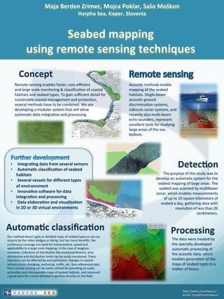
The document describes an automated system for mapping large areas of seabed habitats. It uses multibeam sonar to scan the seabed over areas of up to 10 square kilometers per day with resolution of less than 20 centimeters. The acoustic data is processed using specialized software that can automatically generate maps of seabed types within hours. The goal is to develop a modular system for integrating and processing data from multiple sensors to allow large-scale, cost-effective monitoring and classification of coastal habitats and seabed types.
1 of 1
Download to read offline
Ad
Recommended
STORMTOOLS* -Simplified Flood Inundation Maps for RI with Sea Level Rise (SLR)
STORMTOOLS* -Simplified Flood Inundation Maps for RI with Sea Level Rise (SLR)riseagrant
╠²
The document outlines the vision and tools under development for StormTools, a system designed to provide coastal planning tools accessible via a web service for predicting flooding due to sea level rise (SLR) in Rhode Island. It details the use of high-resolution storm inundation models and extremal analysis to prepare flood maps for different return periods and SLR scenarios. The project also includes plans for a simplified flood mapping strategy and web-based mapping viewer access for public use.C7.05: Ocean Observations Research Coordination Network - Hans-Peter Plag
C7.05: Ocean Observations Research Coordination Network - Hans-Peter PlagBlue Planet Symposium
╠²
The document discusses the Ocean Observations Research Coordination Network's efforts to enhance in-situ coastal observations through new technologies and collaborative data sharing. It emphasizes the integration of satellite and in-situ measurements to improve understanding of ocean processes, particularly in coastal environments. Key recommendations include adopting standard sensors, ensuring data quality, and leveraging automated systems for real-time information exchange.DSD-INT 2017 Delft-FEWS, RIBASIM & iMOD in India - Roelofsen, Hegnauer
DSD-INT 2017 Delft-FEWS, RIBASIM & iMOD in India - Roelofsen, HegnauerDeltares
╠²
The project aims to support strategic basin planning in India through technical assistance, capacity building, and multi-stakeholder engagement, funded by the World Bank with a budget of $2.2 million over two years. It involves advanced modeling of hydrology, groundwater, and water quality to simulate supply and demand scenarios, managing forecasting processes and time series data. The project will enhance the operational capabilities of the Ministry of Water Resources and associated agencies.Leveraging Predictions from NOAAŌĆÖs Oceanographic Forecast Models to Increase ...
Leveraging Predictions from NOAAŌĆÖs Oceanographic Forecast Models to Increase ...Giuseppe Masetti
╠²
This document discusses leveraging oceanographic forecast models to increase environmental awareness in ocean mapping. It presents the Sound Speed Manager and SmartMap tools which integrate predictions from NOAA models to plan surveys and account for water column variability. SmartMap uses forecasts to model acoustic ray propagation through different sound speed scenarios and estimate uncertainty. The tools provide optimal solutions by considering forecasts proactively rather than just reacting to conditions, helping ocean mapping efforts make more informed decisions.OESF Logging Road Sedimentation GIS
OESF Logging Road Sedimentation GISfireflytza
╠²
The document outlines the development of an automated GIS model for analyzing road sedimentation in the Olympic Experimental State Forest (OESF), integrating previous studies and data from the Department of Natural Resources (DNR). It details the creation of a user-friendly interface that addresses specific watershed issues and the challenges encountered in data consistency and watershed sizing. The project demonstrates the effective collaboration between OESF GIS and DNR to enhance forest management practices through improved GIS tools and analysis.HydrOffice: past, present, and future.
HydrOffice: past, present, and future.Giuseppe Masetti
╠²
The document outlines the proceedings of the Hydroffice NOAA Office of Coast Survey Field Procedures Workshop 2018, covering past experiences, present tools, and future challenges in ocean mapping. It highlights various quality control tools, framework libraries, and innovative solutions for ocean mapping as well as ongoing developmental efforts in real-time quality control and integration with GIS applications. The document encourages community feedback and collaboration to tackle future challenges in the field.DSD-INT 2017 Application of the SPHY model for the Ganga basin and integratio...
DSD-INT 2017 Application of the SPHY model for the Ganga basin and integratio...Deltares
╠²
The document discusses the application of the Spatial Processes in Hydrology (SPHY) model for the Ganga River Basin in India, highlighting its use for strategic basin planning and climate impact research. It details the objectives, methodologies, and stakeholder engagement involved in the project, alongside calibration and validation results for the model. The SPHY model is intended to improve river health and economic productivity through enhanced water resource management and accessibility to information.DSD-INT 2017 Urban flood forecasting in central Shanghai (Pudong Area) - Zhang
DSD-INT 2017 Urban flood forecasting in central Shanghai (Pudong Area) - ZhangDeltares
╠²
The document outlines a project focused on urban flood forecasting in the Pudong area of Shanghai using the Delft-FEWS system, which began operations in July 2017. The project aims to utilize a range of integrated data sources for effective decision-making in flood management, addressing challenges such as rapid urban development and extreme weather conditions. It includes detailed system design, operational modes, and future expansion plans to enhance urban flood risk management capabilities.Hydrographic Survey Validation and Chart Adequacy Assessment Using Automated ...
Hydrographic Survey Validation and Chart Adequacy Assessment Using Automated ...Giuseppe Masetti
╠²
This document discusses automated solutions for survey validation and chart adequacy from NOAA and UNH. It introduces the Pydro Universe, a collection of open-source hydrographic tools, and Hydroffice, a research framework that facilitates transitioning research tools to operations. Hydroffice contains quality control and chart adequacy tools that perform tasks like finding outliers in survey data and comparing current surveys to ENCs. The document demonstrates some of these tools and asks which tool attendees would most like to see improved first.Benefits of 3-D Visualization for Drilling, Groundwater Availability, Groundw...
Benefits of 3-D Visualization for Drilling, Groundwater Availability, Groundw...Texas Alliance of Groundwater Districts
╠²
Groundwater districts need easy access to groundwater data for management decisions. A proposed solution is an interactive 3D hydrostratigraphic model of the county's formations, aquifers, water levels, and other data. Previous models created for other districts have been useful for understanding aquifer complexity, water level changes, and assisting with permits and questions. The proposed model would incorporate data from over 500 wells and could help the district with long-term planning and daily decisions.Trusted Crowd-Sourced Bathymetry Project
Trusted Crowd-Sourced Bathymetry ProjectMikkel M├Ėrk
╠²
The 'trusted crowd-sourced bathymetry' project aims to enhance maritime territory monitoring and improve ocean knowledge, especially in the Arctic, by leveraging crowd-sourced data collection. It emphasizes the use of calibrated data loggers to ensure data quality and proposes the development of an open workflow for data analysis. The next steps include collaborating with industry partners to evaluate data logger devices and explore communication solutions for data exchange.A Geospatial Inventory and Preliminary Valuation of Human Uses of Rhode Islan...
A Geospatial Inventory and Preliminary Valuation of Human Uses of Rhode Islan...riseagrant
╠²
The document outlines a two-year project by the University of Rhode Island to gather high-resolution spatial data on human uses of coastal ponds, including user surveys and shellfish population assessments. It describes methods for mapping and valuing these uses, such as intercept surveys and boat-based transect surveys, aiming to understand user interactions and impacts on the environment. The project also focuses on developing indicators for shellfish management and modeling potential impacts of human activities.Pydro & HydrOffice: Open Tools for Ocean Mappers
Pydro & HydrOffice: Open Tools for Ocean MappersGiuseppe Masetti
╠²
The document discusses Pydro and Hydroffice, two open-source tools developed for ocean mapping, focusing on their functionality, integration with various libraries, and the growing community of users. Pydro is a NOAA Python distribution that enables the development of hydrographic applications, while Hydroffice provides a framework for transitioning research into operational tools. It highlights several applications, including sound speed management and chart adequacy tools, alongside the importance of collaboration and accessibility in oceanographic research.MINERAL EXPLORATION USING ASTER IMAGE
MINERAL EXPLORATION USING ASTER IMAGE Abhiram Kanigolla
╠²
The document discusses using ASTER satellite imagery and GIS for mineral exploration. It provides details on two case studies: 1) identifying gold deposits in Nevada using ASTER data integrated into a geodatabase, and 2) mapping alteration zones in India using ASTER shortwave infrared bands. The case studies demonstrate how ASTER imagery can be processed and analyzed using GIS and techniques like principal component analysis to produce geological maps and identify target areas for further mineral exploration.Southside Green - Team 6
Southside Green - Team 6M. Damon Weiss
╠²
The document discusses plans from April 10-12, 2014 for improving connections between a community, water, and park by studying three areas and creating a beautiful entrance from the neighborhood to the park that values history and creates resilient natural systems to manage water and habitat. It also discusses creating a natural play space, ecological communities, upstream considerations, and utilizing wetlands to store stormwater runoff with a total storage volume of over 3.9 million gallons.Ocean Globe, Ocean Geospatial Appliance
Ocean Globe, Ocean Geospatial ApplianceHigh Tech Maui
╠²
The document outlines the services provided by IUE in developing GIS decision support tools for oceanographic data, incorporating high-resolution bathymetry and various environmental factors. It emphasizes the importance of rapid data transfer and visualization, as well as interoperability in managing sparse ocean data. Furthermore, it highlights the diverse applications of these tools in areas such as renewable energy, conservation, and navigation for underwater operations.INMARTECH 2018 - G.Masetti & P.Johnson - Sound Speed Management and Environme...
INMARTECH 2018 - G.Masetti & P.Johnson - Sound Speed Management and Environme...Giuseppe Masetti
╠²
This document discusses sound speed management tools for ocean mapping. It summarizes the Sound Speed Manager, which allows users to manage sound speed profiles. It also discusses SmartMap, a tool that evaluates the effects of oceanographic variability on mapping surveys using ray-tracing. Future developments discussed include continued improvements to these tools, developing regional models for SmartMap, and real-time quality control tools. The document acknowledges funding support from NOAA and NSF.IUKWC Workshop Nov16: Developing Hydro-climatic Services for Water Security ŌĆō...
IUKWC Workshop Nov16: Developing Hydro-climatic Services for Water Security ŌĆō...India UK Water Centre (IUKWC)
╠²
The document discusses challenges in accessing and communicating environmental data in West Bengal, highlighting issues such as the lack of location-specific information, financial and human resource limitations, and the need for simplified communication with stakeholders. It emphasizes the importance of regular updates, improved accessibility to data, and collaborative platforms for dialogue among scientists, policymakers, and field workers. Additionally, it outlines initiatives like climate change action plans and projects for better monitoring and management of water resources.DSD-INT 2020 Real Time Hydrologic, Hydraulic and Water Quality Forecasting in...
DSD-INT 2020 Real Time Hydrologic, Hydraulic and Water Quality Forecasting in...Deltares
╠²
The document discusses a real-time hydrologic, hydraulic, and water quality forecasting system developed by Water Technology in collaboration with Deltares and Flowmatters for the Isaac River catchment. It details the integration of advanced numerical modeling techniques, including radar rainfall calibration, distributed hydrologic modeling, and hydraulic modeling, all operating within a bespoke Delft-FEWS environment. This system aims to optimize water resource management and improve forecasting accuracy for flood and water quality monitoring.Mineral mapping and applications of imaging spectroscopy
Mineral mapping and applications of imaging spectroscopyRemote Sensing GEOIMAGE
╠²
This talk summarizes the use of imaging spectroscopy to map minerals in various environments, including Cuprite, Nevada, Mars, the Moon, and post-9/11 at the World Trade Center site. Imaging spectroscopy can identify minerals like kaolinite, olivine, and buddingtonite and map their distributions. It revealed fire locations and temperatures after 9/11. Advances in algorithms and sensors continue to improve mineral and material mapping abilities.Remote Sensing And GIS Application In Mineral , Oil , Ground Water MappingMin...
Remote Sensing And GIS Application In Mineral , Oil , Ground Water MappingMin...Swetha A
╠²
Remote sensing and GIS techniques can be used to map minerals, oil, and groundwater. For minerals, accommodation zones between faults can localize magmatic material and mineralized fluids, and be identified in satellite images showing brecciation and fault patterns. Oil and gas exploration uses airborne magnetic and gravity surveys integrated with high resolution satellite imagery and DEMs for 3D visualization. Groundwater mapping involves literature review, image interpretation to create spatial databases, field reconnaissance, spatial analysis of data, and identifying recommended recharge structures by analyzing IRS satellite images, groundwater table maps, DEM elevation data, and resistivity curve modeling from electrical soundings.Nearshore Hardbottom Monitoring: Alternative Methods
Nearshore Hardbottom Monitoring: Alternative MethodsKeith VanGraafeiland
╠²
The document discusses alternative methods for monitoring nearshore hardbottom habitats in Florida to enhance efficiency and reduce costs related to beach restoration projects. It highlights technologies such as autonomous underwater mapping systems, unmanned surface vessels, and satellite imagery for habitat assessment and data collection. The use of advanced tools aims to improve quantitative and qualitative analyses while saving costs significantly in the monitoring process.OceanSITES
OceanSITESJCOMMOPS
╠²
The document discusses OceanSITES, a project that collects long-term, high-frequency ocean observations from fixed locations worldwide. OceanSITES aims to collect multidisciplinary data from the full water column and overlying atmosphere. It provides unique temporal behavior insights and reference data to complement other observation approaches. The network benefits members through data sharing and access to infrastructure, training, and leadership opportunities. It holds annual meetings and has over 50 observation sites making physical, optical, biological and chemical measurements globally. A microcat sensor project added more deep ocean temperature and salinity sensors. Data is managed through a format and shared using two global data centers.DSD-INT 2019 SPIT - application of a novel sediment pathway visualization met...
DSD-INT 2019 SPIT - application of a novel sediment pathway visualization met...Deltares
╠²
The document outlines the development and application of the Sediment Pathways Interactive Visualization Tool (SPIT) to enhance understanding of sediment transport in the Columbia River's North Head disposal site. SPIT utilizes existing model outputs to visualize sediment pathways through Lagrangian representations of Euleren flow fields, enabling strategic dredged material placement and stakeholder engagement. The study emphasizes the importance of analyzing sediment transport pathways for coastal management and demonstrates how visualization can simplify complex hydrodynamic processes.Course ENG4903 Professional Practice 2
Course ENG4903 Professional Practice 2John Worrall
╠²
This document summarizes a student project assessing flood impacts in Rockhampton, Australia in 2011 using remote sensing and GIS techniques. Flooding is considered the most costly natural disaster globally. The project aims to estimate flood damage in Rockhampton by quantifying spatial flood extents, developing object-based image processing for feature extraction of inundated areas, applying overlay analysis, and evaluating results in a thematic model. The flood model will add to knowledge of floods in the Fitzroy River catchment and infrastructure impacts.The use of geoinformatics in mineral exploration and exploitation
The use of geoinformatics in mineral exploration and exploitationMarguerite Walsh
╠²
The document discusses the use of geoinformatics, including remote sensing techniques, in mineral exploration and exploitation. It provides several case studies demonstrating how different remote sensing data and techniques can be used to map surface geology and identify potential mineral deposits. These include using Landsat and ASTER satellite imagery to map surficial mineralogy across large areas, detect hydrothermal alteration zones indicating gold mineralization, and identify geothermal anomalies. Integrating remote sensing data with other spatial datasets in a GIS provides additional insights. Future opportunities discussed include the increasing use of unmanned aerial vehicles and the upcoming Sentinel-2 satellite mission.On the Oceanography of BrazilŌĆÖs Equatorial Margin: Hazardous Offshore Current...
On the Oceanography of BrazilŌĆÖs Equatorial Margin: Hazardous Offshore Current...David Fratantoni
╠²
This document discusses the oceanography of Brazil's Equatorial Margin and strategies for mitigating the impact of strong ocean currents. It notes that the region has significant development opportunities but also operational challenges from currents that are strong, variable, and poorly understood. It proposes a regional ocean observing and prediction system using in-situ measurements and ocean models to improve situational awareness of currents and enhance safety of offshore operations. A prototype of such a system is now operational, deploying surface drifters every two weeks and running a regional ocean model daily.C1.06: US IOOS: Eyes on the Ocean - Zdenka Willis
C1.06: US IOOS: Eyes on the Ocean - Zdenka WillisBlue Planet Symposium
╠²
The U.S. Integrated Ocean Observing System (IOOS) serves as a collaborative effort among various federal agencies and regional partners to provide essential ocean, coastal, and Great Lakes data for decision-makers. With a focus on safety, economic enhancement, and environmental protection, IOOS employs various technologies and models to monitor and research marine conditions and ecosystems. The program also emphasizes community engagement and technological innovations to improve observing capabilities.Imagery Interpretation for Coastal and Marine Spatial Planning
Imagery Interpretation for Coastal and Marine Spatial PlanningKeith VanGraafeiland
╠²
The document outlines methods for imagery interpretation in coastal and marine spatial planning to support environmental sensitivity analysis. It details a case study in northern Mozambique, where a geophysical survey aimed to identify and protect sensitive marine habitats while assessing potential impacts from seismic operations. The study utilized remote sensing data and field surveys to create environmental sensitivity index maps and implement mitigation plans for environmental protection.Marine Cartography as a Management Tool
Marine Cartography as a Management ToolEsri
╠²
The document discusses marine cartography as a management tool. It describes oceanographic research vessels and their characteristics. The purpose of the project is to map the Spanish slope and continental shelf through bathymetric mapping, seismic studies, and seabed sampling to acquire detailed information. Indirect data acquisition methods include multibeam echosounders and parametric sub-bottom profilers. Direct methods include ROVs, underwater cameras, box corers, and dredges. Collected data is incorporated into a GIS for analysis and to generate information layers, maps, and models for research and engineering applications.More Related Content
What's hot (20)
Hydrographic Survey Validation and Chart Adequacy Assessment Using Automated ...
Hydrographic Survey Validation and Chart Adequacy Assessment Using Automated ...Giuseppe Masetti
╠²
This document discusses automated solutions for survey validation and chart adequacy from NOAA and UNH. It introduces the Pydro Universe, a collection of open-source hydrographic tools, and Hydroffice, a research framework that facilitates transitioning research tools to operations. Hydroffice contains quality control and chart adequacy tools that perform tasks like finding outliers in survey data and comparing current surveys to ENCs. The document demonstrates some of these tools and asks which tool attendees would most like to see improved first.Benefits of 3-D Visualization for Drilling, Groundwater Availability, Groundw...
Benefits of 3-D Visualization for Drilling, Groundwater Availability, Groundw...Texas Alliance of Groundwater Districts
╠²
Groundwater districts need easy access to groundwater data for management decisions. A proposed solution is an interactive 3D hydrostratigraphic model of the county's formations, aquifers, water levels, and other data. Previous models created for other districts have been useful for understanding aquifer complexity, water level changes, and assisting with permits and questions. The proposed model would incorporate data from over 500 wells and could help the district with long-term planning and daily decisions.Trusted Crowd-Sourced Bathymetry Project
Trusted Crowd-Sourced Bathymetry ProjectMikkel M├Ėrk
╠²
The 'trusted crowd-sourced bathymetry' project aims to enhance maritime territory monitoring and improve ocean knowledge, especially in the Arctic, by leveraging crowd-sourced data collection. It emphasizes the use of calibrated data loggers to ensure data quality and proposes the development of an open workflow for data analysis. The next steps include collaborating with industry partners to evaluate data logger devices and explore communication solutions for data exchange.A Geospatial Inventory and Preliminary Valuation of Human Uses of Rhode Islan...
A Geospatial Inventory and Preliminary Valuation of Human Uses of Rhode Islan...riseagrant
╠²
The document outlines a two-year project by the University of Rhode Island to gather high-resolution spatial data on human uses of coastal ponds, including user surveys and shellfish population assessments. It describes methods for mapping and valuing these uses, such as intercept surveys and boat-based transect surveys, aiming to understand user interactions and impacts on the environment. The project also focuses on developing indicators for shellfish management and modeling potential impacts of human activities.Pydro & HydrOffice: Open Tools for Ocean Mappers
Pydro & HydrOffice: Open Tools for Ocean MappersGiuseppe Masetti
╠²
The document discusses Pydro and Hydroffice, two open-source tools developed for ocean mapping, focusing on their functionality, integration with various libraries, and the growing community of users. Pydro is a NOAA Python distribution that enables the development of hydrographic applications, while Hydroffice provides a framework for transitioning research into operational tools. It highlights several applications, including sound speed management and chart adequacy tools, alongside the importance of collaboration and accessibility in oceanographic research.MINERAL EXPLORATION USING ASTER IMAGE
MINERAL EXPLORATION USING ASTER IMAGE Abhiram Kanigolla
╠²
The document discusses using ASTER satellite imagery and GIS for mineral exploration. It provides details on two case studies: 1) identifying gold deposits in Nevada using ASTER data integrated into a geodatabase, and 2) mapping alteration zones in India using ASTER shortwave infrared bands. The case studies demonstrate how ASTER imagery can be processed and analyzed using GIS and techniques like principal component analysis to produce geological maps and identify target areas for further mineral exploration.Southside Green - Team 6
Southside Green - Team 6M. Damon Weiss
╠²
The document discusses plans from April 10-12, 2014 for improving connections between a community, water, and park by studying three areas and creating a beautiful entrance from the neighborhood to the park that values history and creates resilient natural systems to manage water and habitat. It also discusses creating a natural play space, ecological communities, upstream considerations, and utilizing wetlands to store stormwater runoff with a total storage volume of over 3.9 million gallons.Ocean Globe, Ocean Geospatial Appliance
Ocean Globe, Ocean Geospatial ApplianceHigh Tech Maui
╠²
The document outlines the services provided by IUE in developing GIS decision support tools for oceanographic data, incorporating high-resolution bathymetry and various environmental factors. It emphasizes the importance of rapid data transfer and visualization, as well as interoperability in managing sparse ocean data. Furthermore, it highlights the diverse applications of these tools in areas such as renewable energy, conservation, and navigation for underwater operations.INMARTECH 2018 - G.Masetti & P.Johnson - Sound Speed Management and Environme...
INMARTECH 2018 - G.Masetti & P.Johnson - Sound Speed Management and Environme...Giuseppe Masetti
╠²
This document discusses sound speed management tools for ocean mapping. It summarizes the Sound Speed Manager, which allows users to manage sound speed profiles. It also discusses SmartMap, a tool that evaluates the effects of oceanographic variability on mapping surveys using ray-tracing. Future developments discussed include continued improvements to these tools, developing regional models for SmartMap, and real-time quality control tools. The document acknowledges funding support from NOAA and NSF.IUKWC Workshop Nov16: Developing Hydro-climatic Services for Water Security ŌĆō...
IUKWC Workshop Nov16: Developing Hydro-climatic Services for Water Security ŌĆō...India UK Water Centre (IUKWC)
╠²
The document discusses challenges in accessing and communicating environmental data in West Bengal, highlighting issues such as the lack of location-specific information, financial and human resource limitations, and the need for simplified communication with stakeholders. It emphasizes the importance of regular updates, improved accessibility to data, and collaborative platforms for dialogue among scientists, policymakers, and field workers. Additionally, it outlines initiatives like climate change action plans and projects for better monitoring and management of water resources.DSD-INT 2020 Real Time Hydrologic, Hydraulic and Water Quality Forecasting in...
DSD-INT 2020 Real Time Hydrologic, Hydraulic and Water Quality Forecasting in...Deltares
╠²
The document discusses a real-time hydrologic, hydraulic, and water quality forecasting system developed by Water Technology in collaboration with Deltares and Flowmatters for the Isaac River catchment. It details the integration of advanced numerical modeling techniques, including radar rainfall calibration, distributed hydrologic modeling, and hydraulic modeling, all operating within a bespoke Delft-FEWS environment. This system aims to optimize water resource management and improve forecasting accuracy for flood and water quality monitoring.Mineral mapping and applications of imaging spectroscopy
Mineral mapping and applications of imaging spectroscopyRemote Sensing GEOIMAGE
╠²
This talk summarizes the use of imaging spectroscopy to map minerals in various environments, including Cuprite, Nevada, Mars, the Moon, and post-9/11 at the World Trade Center site. Imaging spectroscopy can identify minerals like kaolinite, olivine, and buddingtonite and map their distributions. It revealed fire locations and temperatures after 9/11. Advances in algorithms and sensors continue to improve mineral and material mapping abilities.Remote Sensing And GIS Application In Mineral , Oil , Ground Water MappingMin...
Remote Sensing And GIS Application In Mineral , Oil , Ground Water MappingMin...Swetha A
╠²
Remote sensing and GIS techniques can be used to map minerals, oil, and groundwater. For minerals, accommodation zones between faults can localize magmatic material and mineralized fluids, and be identified in satellite images showing brecciation and fault patterns. Oil and gas exploration uses airborne magnetic and gravity surveys integrated with high resolution satellite imagery and DEMs for 3D visualization. Groundwater mapping involves literature review, image interpretation to create spatial databases, field reconnaissance, spatial analysis of data, and identifying recommended recharge structures by analyzing IRS satellite images, groundwater table maps, DEM elevation data, and resistivity curve modeling from electrical soundings.Nearshore Hardbottom Monitoring: Alternative Methods
Nearshore Hardbottom Monitoring: Alternative MethodsKeith VanGraafeiland
╠²
The document discusses alternative methods for monitoring nearshore hardbottom habitats in Florida to enhance efficiency and reduce costs related to beach restoration projects. It highlights technologies such as autonomous underwater mapping systems, unmanned surface vessels, and satellite imagery for habitat assessment and data collection. The use of advanced tools aims to improve quantitative and qualitative analyses while saving costs significantly in the monitoring process.OceanSITES
OceanSITESJCOMMOPS
╠²
The document discusses OceanSITES, a project that collects long-term, high-frequency ocean observations from fixed locations worldwide. OceanSITES aims to collect multidisciplinary data from the full water column and overlying atmosphere. It provides unique temporal behavior insights and reference data to complement other observation approaches. The network benefits members through data sharing and access to infrastructure, training, and leadership opportunities. It holds annual meetings and has over 50 observation sites making physical, optical, biological and chemical measurements globally. A microcat sensor project added more deep ocean temperature and salinity sensors. Data is managed through a format and shared using two global data centers.DSD-INT 2019 SPIT - application of a novel sediment pathway visualization met...
DSD-INT 2019 SPIT - application of a novel sediment pathway visualization met...Deltares
╠²
The document outlines the development and application of the Sediment Pathways Interactive Visualization Tool (SPIT) to enhance understanding of sediment transport in the Columbia River's North Head disposal site. SPIT utilizes existing model outputs to visualize sediment pathways through Lagrangian representations of Euleren flow fields, enabling strategic dredged material placement and stakeholder engagement. The study emphasizes the importance of analyzing sediment transport pathways for coastal management and demonstrates how visualization can simplify complex hydrodynamic processes.Course ENG4903 Professional Practice 2
Course ENG4903 Professional Practice 2John Worrall
╠²
This document summarizes a student project assessing flood impacts in Rockhampton, Australia in 2011 using remote sensing and GIS techniques. Flooding is considered the most costly natural disaster globally. The project aims to estimate flood damage in Rockhampton by quantifying spatial flood extents, developing object-based image processing for feature extraction of inundated areas, applying overlay analysis, and evaluating results in a thematic model. The flood model will add to knowledge of floods in the Fitzroy River catchment and infrastructure impacts.The use of geoinformatics in mineral exploration and exploitation
The use of geoinformatics in mineral exploration and exploitationMarguerite Walsh
╠²
The document discusses the use of geoinformatics, including remote sensing techniques, in mineral exploration and exploitation. It provides several case studies demonstrating how different remote sensing data and techniques can be used to map surface geology and identify potential mineral deposits. These include using Landsat and ASTER satellite imagery to map surficial mineralogy across large areas, detect hydrothermal alteration zones indicating gold mineralization, and identify geothermal anomalies. Integrating remote sensing data with other spatial datasets in a GIS provides additional insights. Future opportunities discussed include the increasing use of unmanned aerial vehicles and the upcoming Sentinel-2 satellite mission.On the Oceanography of BrazilŌĆÖs Equatorial Margin: Hazardous Offshore Current...
On the Oceanography of BrazilŌĆÖs Equatorial Margin: Hazardous Offshore Current...David Fratantoni
╠²
This document discusses the oceanography of Brazil's Equatorial Margin and strategies for mitigating the impact of strong ocean currents. It notes that the region has significant development opportunities but also operational challenges from currents that are strong, variable, and poorly understood. It proposes a regional ocean observing and prediction system using in-situ measurements and ocean models to improve situational awareness of currents and enhance safety of offshore operations. A prototype of such a system is now operational, deploying surface drifters every two weeks and running a regional ocean model daily.C1.06: US IOOS: Eyes on the Ocean - Zdenka Willis
C1.06: US IOOS: Eyes on the Ocean - Zdenka WillisBlue Planet Symposium
╠²
The U.S. Integrated Ocean Observing System (IOOS) serves as a collaborative effort among various federal agencies and regional partners to provide essential ocean, coastal, and Great Lakes data for decision-makers. With a focus on safety, economic enhancement, and environmental protection, IOOS employs various technologies and models to monitor and research marine conditions and ecosystems. The program also emphasizes community engagement and technological innovations to improve observing capabilities.Benefits of 3-D Visualization for Drilling, Groundwater Availability, Groundw...
Benefits of 3-D Visualization for Drilling, Groundwater Availability, Groundw...Texas Alliance of Groundwater Districts
╠²
IUKWC Workshop Nov16: Developing Hydro-climatic Services for Water Security ŌĆō...
IUKWC Workshop Nov16: Developing Hydro-climatic Services for Water Security ŌĆō...India UK Water Centre (IUKWC)
╠²
On the Oceanography of BrazilŌĆÖs Equatorial Margin: Hazardous Offshore Current...
On the Oceanography of BrazilŌĆÖs Equatorial Margin: Hazardous Offshore Current...David Fratantoni
╠²
Similar to Poster Conservation biology (20)
Imagery Interpretation for Coastal and Marine Spatial Planning
Imagery Interpretation for Coastal and Marine Spatial PlanningKeith VanGraafeiland
╠²
The document outlines methods for imagery interpretation in coastal and marine spatial planning to support environmental sensitivity analysis. It details a case study in northern Mozambique, where a geophysical survey aimed to identify and protect sensitive marine habitats while assessing potential impacts from seismic operations. The study utilized remote sensing data and field surveys to create environmental sensitivity index maps and implement mitigation plans for environmental protection.Marine Cartography as a Management Tool
Marine Cartography as a Management ToolEsri
╠²
The document discusses marine cartography as a management tool. It describes oceanographic research vessels and their characteristics. The purpose of the project is to map the Spanish slope and continental shelf through bathymetric mapping, seismic studies, and seabed sampling to acquire detailed information. Indirect data acquisition methods include multibeam echosounders and parametric sub-bottom profilers. Direct methods include ROVs, underwater cameras, box corers, and dredges. Collected data is incorporated into a GIS for analysis and to generate information layers, maps, and models for research and engineering applications.Keith cooper day_3_session_7
Keith cooper day_3_session_7Jennifer Geroni
╠²
(1) The document presents a new approach to macrofaunal baseline assessment, monitoring, and sustainable exploitation of the seabed using big data. (2) Over 33,000 samples were collected and analyzed to characterize faunal assemblages, relate fauna to sediment composition, and establish a method to assess sediment change from dredging. (3) Online tools were developed to provide the faunal baseline, relate fauna and sediments, and assess sediment change, enabling more effective environmental management and monitoring.HWU Industry day 2012
HWU Industry day 2012Heriot-Watt University
╠²
Cold-water coral reefs located in deep marine environments between 40-3000 meters are at risk from ocean acidification and rising temperatures. These ecosystems support high biodiversity but are difficult to study due to their depth. Researchers use submersibles, ROVs, multibeam sonar and other acoustic sensors to map and model these areas, helping to understand environmental impacts and informing conservation efforts. New sensor technologies aim to improve monitoring of carbon chemistry critical to these habitats.Presentation: Fee & Brigley
Presentation: Fee & BrigleyCOGS Presentations
╠²
Remote sensing was used to map coastal environments in Nova Scotia for various applications. In Little Harbour, multispectral imagery was classified to map eelgrass extent. For Isle Madame, imagery was classified to inventory land cover and assess vulnerability to oil spills. In Shag Harbour, multispectral imagery and lidar were used to map rockweed spatial distribution for a seaweed company. High resolution coastal data allows efficient environmental monitoring and management.Methods for the study of marine benthos 3rd ed Edition Anastasios Elefteriou
Methods for the study of marine benthos 3rd ed Edition Anastasios Elefterioueguenszavos
╠²
Methods for the study of marine benthos 3rd ed Edition Anastasios Elefteriou
Methods for the study of marine benthos 3rd ed Edition Anastasios Elefteriou
Methods for the study of marine benthos 3rd ed Edition Anastasios ElefteriouPoster submission #354 viability study of a costumized gis for the berlenga...
Poster submission #354 viability study of a costumized gis for the berlenga...Ædel Aerospace GmbH
╠²
This document summarizes the initial results of an ongoing viability study for establishing a customized GIS for marine biology monitoring in the Berlengas Natural Reservation off the coast of Peniche, Portugal. Preliminary surveys were conducted using low-cost systems like balloons, SCUBA gear, and an ROV to gather surface and underwater data. Initial scientific dives found underwater debris that will be analyzed to help design specialized data gathering modules for the GIS. Future developments may include stationary and mobile floating platforms using technologies like APRS to further customize the GIS and improve its ability to support local ecotourism and research activities.Methods for the study of marine benthos 3rd ed Edition Anastasios Elefteriou
Methods for the study of marine benthos 3rd ed Edition Anastasios Elefterioutuadermnsuri
╠²
Methods for the study of marine benthos 3rd ed Edition Anastasios Elefteriou
Methods for the study of marine benthos 3rd ed Edition Anastasios Elefteriou
Methods for the study of marine benthos 3rd ed Edition Anastasios ElefteriouPredicting suitable habitat for the european lobster, by Ibon Galparsoro, EUR...
Predicting suitable habitat for the european lobster, by Ibon Galparsoro, EUR...DTU - Technical University of Denmark
╠²
The document outlines a training workshop focused on statistical modeling tools aimed at developing habitat models for predicting the suitable habitat of the European lobster (Homarus gammarus) on the Basque continental shelf. Key objectives included identifying seafloor characteristics and creating habitat suitability models using ecological-niche factor analysis (ENFA), which resulted in significant findings regarding lobster habitat preferences and the impact of environmental variables. Future work will enhance the model's accuracy and examine the effects of changing environmental conditions on lobster distribution.NASA HSI Workshop at UCSB 08/05/2008
NASA HSI Workshop at UCSB 08/05/2008pbissett
╠²
The document discusses the challenges and advancements in coastal airborne hyperspectral imaging (HSI), particularly emphasizing the difficulties in imaging dark targets like water due to signal attenuation and lack of robust sensors. It highlights the capabilities of the SAMSON system, which provides high-quality HSI data and enables automated feature extraction for various applications, including environmental monitoring. The summary also stresses the need for standardized workflows and sensors to improve accessibility and demand for these technologies.Seagrass mapping and monitoring along the coast of Crete, Greece. Mid-Term Pr...
Seagrass mapping and monitoring along the coast of Crete, Greece. Mid-Term Pr...Universit├żt Salzburg
╠²
This mid-term MSc thesis presents research focused on mapping and monitoring seagrass meadows, specifically Posidonia oceanica, along the coast of Crete, Greece, using aerial and satellite imagery over a 10-year period. The study involves GIS and remote sensing techniques to assess the spatial distribution and environmental changes affecting seagrass meadows, based on primary data from fieldwork and secondary data from satellite sources. The objectives include detailed classification of seagrass distribution and analysis of the spectral reflectance to distinguish seagrass from other seafloor types.Seagrass Mapping and Monitoring Along the Coasts of Crete, Greece
Seagrass Mapping and Monitoring Along the Coasts of Crete, GreeceUniversit├żt Salzburg
╠²
The document is a research proposal focused on seagrass mapping and monitoring along the coast of Crete, Greece, specifically studying the species Posidonia oceanica. It aims to assess the spatial distribution and health of seagrass meadows using satellite imagery and fieldwork data, along with evaluating the impacts of environmental changes over a 10-year period. The research will employ various remote sensing and GIS methods to achieve accurate mappings for coastal management and conservation efforts.Simon Barchard, RESON
Simon Barchard, RESONHydrographic Society Benelux
╠²
Multi-beam echo sounders can be used for more than just bathymetry. They can be used for bottom classification, leak detection, harbor protection, and detecting sunken heavy oil. A test was conducted at the Ohmsett test facility to detect different types of sunken oil using multi-beam echo sounder data and acoustic backscatter properties. The results showed a 91% detection rate of oil areas with a 20% false alarm rate on non-oil areas.Bruce Carlisle Massachusetts Ocean Management: Implementation Progress and Re...
Bruce Carlisle Massachusetts Ocean Management: Implementation Progress and Re...riseagrant
╠²
The document summarizes Massachusetts' progress in implementing its Ocean Management Plan. Key points include:
- The plan established siting standards and identified/mapped special marine habitats and areas of high existing ocean use to guide protection and development.
- Agencies are coordinating regulatory decisions and prioritizing science like improved mapping of habitats and recreational boating data.
- A case study showed how standards guided a cable project to avoid sensitive habitats through routing changes and construction methods.
- An Ecological Valuation Index was developed to systematically evaluate habitat importance, though it has limitations due to data availability.Pcra lecture (camotes pcra orientation)
Pcra lecture (camotes pcra orientation)Shaina Mavreen Villaroza
╠²
The document outlines a lecture on coastal resource assessment and management in the Philippines. It discusses the importance of coastal resources, participatory coastal resource assessment (PCRA), and different monitoring methods used in PCRA like manta tow surveys, transect surveys, and fish visual censuses. These methods are used to collect data on coastal habitats, fisheries, and socioeconomic factors to identify issues and inform management guidelines. The lecture aims to familiarize participants with PCRA and apply participatory methods in an actual coastal assessment.Southeastern US Marine Ecosystems and Hydrocarbon Exploration
Southeastern US Marine Ecosystems and Hydrocarbon Explorationjclark_selc
╠²
This document discusses marine ecosystems and hydrocarbon exploration in the southeastern United States. It notes the high biodiversity in estuaries and coastal waters, as well as the influence of the Gulf Stream on regional oceanography. While nearshore areas are relatively well-studied, knowledge declines rapidly with increasing distance offshore and depth. Important issues include degraded habitat and overfishing. Further research is needed on deep-sea and mesopelagic environments over 200 meters deep to better understand biology, habitats, and connectivity in these poorly known areas.Application of remote sensing in coastal zone management
Application of remote sensing in coastal zone managementMayur Tade
╠²
This document discusses the application of remote sensing in coastal zone management. It begins with an introduction to coastal zones and their importance. It then discusses remote sensing concepts like the electromagnetic spectrum and geographical information systems (GIS). The main applications of remote sensing discussed are the study of coastal habitats like coral reefs and mangroves, shoreline protection, monitoring marine water quality, understanding marine environment and climate change impacts, and aiding coastal zone management. Specific examples are provided of how remote sensing has been used to map and monitor these coastal features and issues in India.Final Manuscript ACCURATE COLD SEEP IDENTIFICATION etc_Rev AJD_25-2-2016
Final Manuscript ACCURATE COLD SEEP IDENTIFICATION etc_Rev AJD_25-2-2016Adrian Digby
╠²
The document describes a new multi-beam survey methodology used to map cold seeps and structured benthic communities in the Gran Fuerte area of the Colombian Caribbean. Key findings:
1) The methodology involved double coverage of the survey area to eliminate backscatter artifacts and more accurately map seep boundaries and categorize seeps.
2) Over 200 cold seeps ranging in size were identified, with 93% of predicted seeps confirmed by sediment cores.
3) Seeps could be categorized as "dense", "low density", or "traces" based on backscatter patterns, indicating activity levels.
4) Drift camera surveys confirmed communities identified by the new methodology. No hard substratesMappingMangroves
MappingMangrovesAlvin Alcindor
╠²
This document summarizes a study that aimed to map mangrove species in the Seychelles using remote sensing techniques. The study area was Port Launay wetland on Mahe island, which contains seven mangrove species. Field data was collected using GPS to record species locations and analyze spatial patterns. A Pleiades satellite image was analyzed to classify and map the mangrove species distributions. Issues encountered included tidal access limitations and canopy cover obscuring understory species. The analysis will produce a final mangrove species classification map and provide methodology for future remote sensing wetland studies.Diversitas Danis
Diversitas DanisBruno Danis
╠²
This document discusses the SCAR-MarBIN (Marine Biodiversity Information Network) project which aims to quantify Antarctic marine biodiversity. It notes that Antarctic biodiversity is highly endemic but understudied, especially in deep-sea environments. SCAR-MarBIN builds an open-access network of over 60 editors to aggregate data on over 16,000 Antarctic taxa and 9,234 species from 130 datasets. The project helps identify gaps in knowledge, promotes new initiatives to increase data, and builds bridges across disciplines and nations to advance conservation and management of Antarctic ecosystems.Poster submission #354 viability study of a costumized gis for the berlenga...
Poster submission #354 viability study of a costumized gis for the berlenga...Ædel Aerospace GmbH
╠²
Predicting suitable habitat for the european lobster, by Ibon Galparsoro, EUR...
Predicting suitable habitat for the european lobster, by Ibon Galparsoro, EUR...DTU - Technical University of Denmark
╠²
Seagrass mapping and monitoring along the coast of Crete, Greece. Mid-Term Pr...
Seagrass mapping and monitoring along the coast of Crete, Greece. Mid-Term Pr...Universit├żt Salzburg
╠²
Ad
Poster Conservation biology
- 1. ŌĆóŌĆ» ╠²Integra)ng ╠²data ╠²from ╠²several ╠²sensors ╠² ŌĆóŌĆ» ╠²Automa)c ╠²classi’¼üca)on ╠²of ╠²seabed ╠² ╠² habitats ╠² ŌĆóŌĆ» ╠²Several ╠²vessels ╠²for ╠²di’¼Ćerent ╠²types ╠² ╠² of ╠²environnment ╠² ŌĆóŌĆ» ╠²Innova)ve ╠²so<ware ╠²for ╠²data ╠² ╠² integra)on ╠²and ╠²processing ╠² ŌĆóŌĆ» ╠²Data ╠²elabora)on ╠²and ╠²visualisa)on ╠² ╠² in ╠²2D ╠²or ╠²3D ╠²virtual ╠²environments ╠² ╠² ╠² ╠² ╠² Acous'c ╠²methods ╠²enable ╠² mapping ╠²of ╠²the ╠²seabed ╠² habitats. ╠²Single-┬ŁŌĆÉbeam ╠² acous'c ╠²ground ╠² discrimina'on ╠²systems, ╠² sidescan ╠²sonar ╠²systems, ╠²and ╠² recently ╠²also ╠²mul'-┬ŁŌĆÉbeam ╠² echo ╠²sounders, ╠²represent ╠² excellent ╠²tools ╠²for ╠²studying ╠² large ╠²areas ╠²of ╠²the ╠²sea-┬ŁŌĆÉ bo<om. ╠² ╠² Detec)on ╠² The ╠²purpose ╠²of ╠²this ╠²study ╠²was ╠²to ╠² develop ╠²an ╠²automa'c ╠²system ╠²for ╠²the ╠² seabed ╠²mapping ╠²of ╠²large ╠²areas. ╠²The ╠² seabed ╠²was ╠²scanned ╠²by ╠²mul'beam ╠² sonar, ╠²which ╠²enables ╠²measurements ╠² of ╠²up ╠²to ╠²10 ╠²square ╠²kilometers ╠²of ╠² seabed ╠²a ╠²day, ╠²gathering ╠²data ╠²with ╠² resolu'on ╠²of ╠²less ╠²than ╠²20 ╠² cen'meters. ╠² ╠² Concept ╠² Remote ╠²sensing ╠²enables ╠²faster, ╠²cost-┬ŁŌĆÉe’¼ācient ╠² ╠² and ╠²large ╠²scale ╠²monitoring ╠²& ╠²classi’¼üca'on ╠²of ╠²coastal ╠² habitats ╠²and ╠²seabed ╠²types. ╠²To ╠²gain ╠²su’¼ācient ╠²detail ╠²for ╠² sustainable ╠²coastal ╠²management ╠²and ╠²protec'on, ╠² several ╠²methods ╠²have ╠²to ╠²be ╠²combined. ╠²We ╠²are ╠² developing ╠²a ╠²modular ╠²system ╠²that ╠²will ╠²allow ╠² automa'c ╠²data ╠²integra'on ╠²and ╠²processing. ╠² ╠² The ╠²data ╠²were ╠²treated ╠²by ╠² the ╠²specially ╠²developed ╠² automa'c ╠²processing ╠²of ╠² the ╠²acous'c ╠²data, ╠²which ╠² enables ╠²genera'on ╠²of ╠²the ╠² maps ╠²of ╠²seabed ╠²types ╠²in ╠²a ╠² ma<er ╠²of ╠²hours. ╠² ╠² Processing ╠² h<p://www.harphasea.si ╠² email: ╠²maja@harphasea.si ╠² Our ╠²method ╠²doesn't ╠²give ╠²as ╠²detailed ╠²maps ╠²of ╠²seabed ╠²types ╠²as ╠²we ╠²can ╠² acquire ╠²by ╠²the ╠²video ╠²sledges ╠²or ╠²diving, ╠²but ╠²has ╠²many ╠²bene’¼üts, ╠²like ╠² con'nuous ╠²coverage ╠²(no ╠²need ╠²for ╠²interpola'on), ╠²speed ╠²and ╠² applicability ╠²to ╠²a ╠²large ╠²scale ╠²mapping. ╠²In ╠²the ╠²case ╠²of ╠²seagrass ╠² meadows, ╠²indicators ╠²of ╠²distribu'on ╠²like ╠²presence/absence, ╠²area ╠² distribu'on ╠²and ╠²distribu'on ╠²limits ╠²can ╠²be ╠²easily ╠²monitored. ╠²These ╠² indicators ╠²can ╠²be ╠²a’¼Ćected ╠²by ╠²eutrophica'on, ╠²changes ╠²in ╠²coastal ╠² infrastructure, ╠²dredging, ╠²anchoring, ╠²tra’¼āc, ╠²etc. ╠²Geo-┬ŁŌĆÉreferenced ╠²data ╠² from ╠²remote ╠²sensing ╠²can ╠²be ╠²easily ╠²u'lized ╠²for ╠²providing ╠²an ╠²easily ╠² accessible ╠²and ╠²interoperable ╠²maps ╠²of ╠²seabed ╠²habitats, ╠²and ╠²represent ╠² a ╠²good ╠²basis ╠²for ╠²a ╠²more ╠²detailed ╠²inspec'on ╠²directly ╠²on ╠²the ╠²’¼üeld. ╠² ╠² Automa)c ╠²classi’¼üca)on ╠² ╠²