


More Related Content
Similar to Wps (20)
More from Ayutthaya GIS (9)


Wps
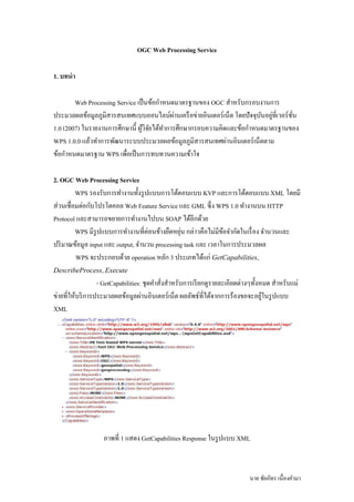
- 1. OGC Web Processing Service 1. āļāļāļāđāļē āđ Web Processing Service āđāļāđ āļāļāđāļāļāļēāļŦāļāļāļĄāļēāļāļĢāļāļēāļāļāļāļ OGC āļŠāđāļēāļŦāļĢāļąāļāļāļĢāļāļāļāļēāļāļāļēāļĢ āđ āđ āļą āđ āļāļĢāļ°āļĄāļ§āļĨāļāļĨāļāđāļāļĄāļđāļĨāļ āļđāļĄāļīāļŠāļēāļĢāļŠāļāđāļāļĻāđāļāļāļāļāļāđāļĨāļāđāļāļēāļāđāļāļĢāļ· āļāļāļēāļĒāļāļīāļāđāļāļāļĢāđ āđāļāđāļ āđāļāļĒāļāļą āļāļāļļāļāļāļāļĒāļđāļāļĩāđāļ§āļāļĢāđ āļāļ āļą āđāļīāļą āđ āđ 1.0 (2007) āđāļāļĢāļēāļĒāļāļēāļāļāļēāļĢāļĻāļķāļāļĐāļēāļāļĩ āļāļđāļ§āļāļĒāđāļāđāļāļēāļāļēāļĢāļĻāļķāļāļĐāļēāļāļĢāļāļāļāļ§āļēāļĄāļāļīāļāđāļĨāļ°āļāđāļāļāļēāļŦāļāļāļĄāļēāļāļĢāļāļēāļāļāļāļ āđ WPS 1.0.0 āđāļĨāđāļ§āļāđāļēāļāļēāļĢāļāļąāļāļāļēāļĢāļ°āļāļāļāļĢāļ°āļĄāļ§āļĨāļāļĨāļāđāļāļĄāļđāļĨāļ āļđāļĄāļīāļŠāļēāļĢāļŠāļāđāļāļĻāļāļēāļāļāļīāļāđāļāļāļĢāđ āđāļāđāļāļāļēāļĄ āđ āļāđāļāļāļēāļŦāļāļāļĄāļēāļāļĢāļāļēāļ WPS āđāļāļ·āļāđāļāđ āļāļāļēāļĢāļāļāļāļ§āļāļāļ§āļēāļĄāđāļāđāļēāđāļ 2. OGC Web Processing Service WPS āļĢāļāļāļĢāļąāļāļāļēāļĢāļāđāļēāļāļēāļāļāļąāļāļĢāļđ āļāđāļāļāļāļēāļĢāđāļāđāļāļāļāđāļāļ KVP āđāļĨāļ°āļāļēāļĢāđāļāđāļāļāļāđāļāļ XML āđāļāļĒāļĄāļĩ āđ āđ āļą āļŠāļ§āļāđāļāļ·āļāļĄāļāļāļāļāđāļāļĢāđāļāļāļāļĨ Web Feature Service āđāļĨāļ° GML āļāļķ āļ WPS 1.0 āļāđāļēāļāļēāļāļāļ HTTP Protocol āđāļĨāļ°āļŠāļēāļĄāļēāļĢāļāļāļĒāļēāļĒāļāļēāļĢāļāđāļēāļāļēāļāđāļāļāļ SOAP āđāļāđāļāļĩāļāļāđāļ§āļĒ āđ āđ āđ āđ āđ āļą WPS āļĄāļĩāļĢāļđāļāđāļāļāļāļēāļĢāļāđāļēāļāļēāļāļāļĩāļāļāļāļāđāļēāļāļĒāļ·āļāļŦāļĒāļļāļ āļāļĨāļēāļ§āļāļ·āļāđāļĄāļĄāļĩāļāļāļāđāļēāļāļāđāļāđāļĢāļ· āļāļ āļāđāļēāļāļ§āļāđāļĨāļ° āļāļĢāļī āļĄāļēāļāļāđāļāļĄāļđāļĨ input āđāļĨāļ° output, āļāđāļēāļāļ§āļ processing task āđāļĨāļ° āđāļ§āļĨāļēāđāļāļāļēāļĢāļāļĢāļ°āļĄāļ§āļĨāļāļĨ WPS āļāļ°āļāļĢāļ°āļāļāļāļāđāļ§āļĒ operation āļŦāļĨāļąāļ 3 āļāļĢāļ°āđāļ āļāđāļāđāđāļāđ GetCapabilities, DescribeProcess, Execute āđ - GetCapabilities: āļāļļāļāļāđāļēāļŠāļąāļāļŠāđāļēāļŦāļĢāļąāļāļāļēāļĢāđāļĢāļĩ āļĒāļāļāļđāļĢāļēāļĒāļĨāļ°āđāļāļĩāļĒāļāļāļēāļāđāļāļąāļāļŦāļĄāļ āļŠāđāļēāļŦāļĢāļąāļāđāļĄāđ āđ āđ āļāļēāļĒāļāļĩāđāļŦāđāļāļĢāļī āļāļēāļĢāļāļĢāļ°āļĄāļ§āļĨāļāļĨāļāđāļāļĄāļđāļĨāļāļēāļāļāļīāļāđāļāļāļĢāđ āđāļāđāļ āļāļĨāļĨāļąāļāļāđāļāļĩāđāļāđāļāļēāļāļāļēāļĢāļĢāđāļāļāļāļāļāļ°āļāļĒāļđāđāđāļāļĢāļđ āļāđāļāļ XML āļ āļēāļāļāļĩ 1 āđāļŠāļāļ GetCapabilities Response āđāļāļĢāļđ āļāđāļāļ XML āļāļēāļĒ āļāļąāļĒāļ āļąāļāļĢ āđāļāļ·āļāļāļāđāļēāļĄāļē
- 2. Processing Information āđ āļ āļēāļāļāļĩ 2 āđāļŠāļāļāļŠāļ§āļāļāļāļ Processing Information āđāļ GetCapabilities Response - DescribeProcess: āļāļļāļāļāđāļēāļŠāļąāļāļŠāđāļēāļŦāļĢāļąāļāļāļēāļĢāđāļĢāļĩ āļĒāļāļāļđāļĢāļēāļĒāļĨāļ°āđāļāļĩāļĒāļāļŠāđāļēāļŦāļĢāļąāļ Processing āđāđ āđ Method āđāļāđāļĨāļ°āļāļąāļ§āļāļāđāļĄāļāļēāļĒ āđāļāļ āļāļĢāļ°āđāļ āļāļāļāļāļāļēāļĢāļāļĢāļ°āļĄāļ§āļĨāļāļĨ, āļāļēāļĢāļēāļĄāļīāđāļāļāļĢāđ āđāļĨāļ°āļāļĨāļĨāļąāļāļāđāļāļĩāđāļāđ āđāļāļĒāļāļđ āđ āđ āļĢāđāļāļāļāļāļāđāļāļāļāđāļēāļāļēāļĢāļĢāļ°āļāļļ identifier āļāļĨāļĨāļąāļāļāđāļāļĩāđāļāđāļāļ°āļāļĒāļđāđāļāļĢāļđ āļāđāļāļ āđāļāļāļŠāļēāļĢ XML āļāļąāļāļ āļēāļāļāļĩ 3 Output Data āļ āļēāļāļāļĩ 4 āđāļŠāļāļāļāļĨāļĨāļąāļāļāđāļāļāļ Describeprocess āļŠāđāļēāļŦāļĢāļąāļāļāļēāļĢāļāđāļēāļāļ§āļ Union āļāļēāļĒ āļāļąāļĒāļ āļąāļāļĢ āđāļāļ·āļāļāļāđāļēāļĄāļē
- 3. - Execute: āļāļ·āļāļāļļāļāļāđāļēāļŠāļąāļāļāļēāļĢāļāļĢāļ°āļĄāļ§āļĨāļāļĨ āđāļāļĒāļāļđāđāļāđāļāļ°āļāđāļēāļāļēāļĢāļĢāļ°āļāļļāļāđāļēāļāļēāļĢāļēāļĄāļīāđāļāļāļĢāđ āļāđāļēāļāđ āđ āđ āļŠāđāļēāļŦāļĢāļąāļāļāļēāļĢāļāļĢāļ°āļĄāļ§āļĨāļāļĨāļāļēāļĄāļāļĩāđāļāđāļāļēāļŦāļāļāđāļ§āđ āļāļĨāļĨāļąāļāļāđāļāļĩāđāļāđāļāļēāļāļāļļāļāļāđāļēāļŠāļąāļāļāļĩāļāļ°āđāļāđ āļ āļāļĨāļĨāļąāļāļāđāļāļāļāļāļēāļĢ āļāļĢāļ°āļĄāļ§āļĨāļāļĨ āļ āļēāļāļāļĩ 5 āđāļŠāļāļāđāļāļāļŠāļēāļĢ XML āļŠāđāļēāļŦāļĢāļąāļāļāļēāļĢāļŠāļąāļāļāļēāļāļāļĢāļ°āļĄāļ§āļĨāļāļĨāļāđāļāļĄāļđāļĨ āļ āļēāļāļāļĩ 6 āđāļŠāļāļāđāļāļāļ°āđāļāļĢāļĄāļŠāđāļēāļŦāļĢāļąāļāļāļēāļĢāđāļāđāļāļāļāļāļāļ Web Processing Service āļāļēāļĒ āļāļąāļĒāļ āļąāļāļĢ āđāļāļ·āļāļāļāđāļēāļĄāļē
- 4. 3. āļāļēāļĢāļāļāļĨāļāļāļāļąāļāļāļēāļĢāļ°āļāļ Online WPS āđ āđ āđāļāļ·āļāļāļāļēāļ WPS āđāļāđ āļāļāđāļāļāļēāļŦāļāļāļĄāļēāļāļĢāļāļēāļāļāļĩāļĄāļĩāļĢāļēāļĒāļĨāļ°āđāļāļĩāļĒāļāđāļāđāļāđāļāļīāļāđāļāļĢāđāļāļĢāļĄāļĄāļīāļāļĄāļēāļāļāļ§āļēāļāđāļē āļī āļāļĢāļĢāļāļĒāļēāļĒ āļāļąāļāļāļąāļāđāļāļ·āļāđāļŦāđāđāļāļāļāļ§āļēāļĄāđāļāđāļēāđāļāđāļāļāļēāļĢāļāđāļēāļāļēāļ āļāļđāļ§āļāļĒāļāļķāļāđāļāđāļāļēāļāļēāļĢāļāļāļĨāļāļāļāļąāļāļāļēāļĢāļ°āļāļ āđāļīāļą āđ āđ āļāļĢāļ°āļĄāļ§āļĨāļāļĨāļāļāļāđāļĨāļāđāļāļēāļĄāļāđāļāļāļēāļŦāļāļāļĄāļēāļāļĢāļāļēāļ WPS āđāļāļĒāđāļāđ POSTGIS āđāļāđ āļāđāļāļĢāļ· āļāļāļĄāļ·āļ āļŠāđāļēāļŦāļĢāļąāļāļāļēāļĢ āļāļĢāļ°āļĄāļ§āļĨāļāļĨāļāđāļāļĄāļđāļĨāļ āļđāļĄāļīāļŠāļēāļĢāļŠāļāđāļāļĻ āđāļĨāļ°āđāļāđāļ āļēāļĐāļē PL/SQL āđāļāļāļēāļĢāļāļ§āļāļāļļāļĄāđāļĨāļ°āļāļąāļāļāļēāļĢāļāđāļāļĄāļđāļĨāļŠāđāļēāļŦāļĢāļąāļ āļāļĢāļ°āļĄāļ§āļĨāļāļĨ āđāļāļĒāđāļāļāļēāļĢāļāđāļēāļāļēāļāļāļąāļāļāļđāļĻāļķāļāļĐāļēāđāļāđāļāļĒāļēāļĒāļāļ§āļēāļĄāļŠāļēāļĄāļēāļĢāļāļāļāļāļĢāļ°āļāļ āđāļŦāđāļĢāļāļāļĢāļąāļāļāļĢāļ°āđāļ āļāļāļāļ āđ āļą āļāđāļāļĄāļđāļĨāļāļĢāļī āļ āļđāļĄāļīāđāļāļ Well Know Text āļāļķ āļāđāļŦāļĄāļēāļ°āļŠāļĄāļāļāļāļēāļāļāđāļāļĄāļđāļĨāđāļāļīāļāļāļ·āļāļāļĩ āđ āđāļāļāļēāļĢāļāļąāļāļāļēāļĢāļ°āļāļāļāđāļēāđāļāđ āļāļāļĩāļāđāļāļāđāļāđāđāļāļāđāļāđāļĨāļĒāļĩ AJAX āđāļāļāļēāļĢāļĢāļąāļāļŠāļāļāđāļāļĄāļđāļĨ āđāļāļĒāļāļđāļāļāļāļēāđāļāđ āđ āļą āđ āđāļāđ Openlayers Framework āđāļāđ āļāļāļ·āļāļāļēāļāđāļāļāļēāļĢāļāļąāļāļāļēāļŠāļ§āļāļāļāļ WPS Client āļ āļēāļāļāļĩ 7 āđāļŠāļāļāļŠāļāļēāļāļą āļāļĒāļāļĢāļĢāļĄāļāļāļāļĢāļ°āļāļ Online Processing Service āđ 3.1 āļāļąāļ§āļāļĒāļēāļāļāļēāļĢāļāđāļēāļāļēāļāļāļāļāļĢāļ°āļāļ āđ āđ 3.1.1 āļāļēāļŦāļāļāļāđāļāļĄāļđāļĨ Geometry Data āđāļĨāļ°āļāļēāļāļēāļĢāļēāļĄāļīāđāļāļāļĢāđ āļŠāļēāļŦāļĢāļąāļāļāļēāļĢāļāļĢāļ°āļĄāļ§āļĨāļāļĨ āđ āļāļēāļĒ āļāļąāļĒāļ āļąāļāļĢ āđāļāļ·āļāļāļāđāļēāļĄāļē
- 5. āđ āļāļēāļŦāļāļ Process āđ āļāļēāļŦāļāļ Input Data āđ āļāļēāļŦāļāļ Input Data āļ āļēāļāļāļĩ 8 āđāļŠāļāļāļāļēāļĢāļāđāļēāļāļēāļāļāļāļāļĢāļ°āļāļ Online Processing Service āļ āļēāļāļāļĩ 9 āđāļŠāļāļāļāđāļāļĄāļđāļĨāļāļĨāļĨāļąāļāļāđāļāļēāļāļāļēāļĢāļāļĢāļ°āļĄāļ§āļĨāļāļĨ āļāļēāļĒ āļāļąāļĒāļ āļąāļāļĢ āđāļāļ·āļāļāļāđāļēāļĄāļē