9 đżđ╣đŻ ĐüĐâđ┤đ░đ╗đ│đ░đ░đŻđ┤ đĚĐéĐü-đ│ đ░ĐłđŞđ│đ╗đ░Đů đŻĐî - đĚ.đŻđ░ĐÇđ░đŻđ│ĐŹĐÇĐŹđ╗
0 likes2,121 views


More Related Content
What's hot (20)
Viewers also liked (14)


More from GeoMedeelel (20)


9 đżđ╣đŻ ĐüĐâđ┤đ░đ╗đ│đ░đ░đŻđ┤ đĚĐéĐü-đ│ đ░ĐłđŞđ│đ╗đ░Đů đŻĐî - đĚ.đŻđ░ĐÇđ░đŻđ│ĐŹĐÇĐŹđ╗
- 1. đĹđ░đ╣đ│đ░đ╗Đî đżĐÇĐçđŞđŻ, đ░ĐĆđ╗đ░đ╗ đÂĐâĐâđ╗Đçđ╗đ░đ╗ĐőđŻ ĐĆđ░đ╝ đĹđ░đ╣đ│đ░đ╗Đî đżĐÇĐçđŻĐő đ╝ĐŹđ┤ĐŹĐŹđ╗đ╗đŞđ╣đŻ ĐéËęđ▓ đ×đÖđŁ đíđúđöđÉđŤđôđÉđÉđŁđö đŚđÉđÖđŁđÉđÉđí đóđÉđŁđöđÉđŁ đíđúđöđŤđÉđŤđźđô đÉđĘđśđôđŤđÉđą đŁđČ ÔÇťđĹđ░đ╣đ│đ░đ╗Đî đżĐÇĐçđŻĐő Đéđ░đŻđ┤đ░đŻ ĐüĐâđ┤đ╗đ░đ╗-40 đÂđŞđ╗ÔÇŁ ĐüĐŹđ┤ĐŹđ▓Đé ĐŹĐÇđ┤ĐŹđ╝ ĐłđŞđŻđÂđŞđ╗đ│ĐŹĐŹđŻđŞđ╣ ĐůĐâĐÇđ░đ╗ đŚ.đŁđ░ĐÇđ░đŻđ│ĐŹĐÇĐŹđ╗ đĹđ×đťđó-đŞđ╣đŻ đťĐŹđ┤ĐŹĐŹđ╗đ╗đŞđ╣đŻ đ╝đÁđŻđÁđÂđ╝đÁđŻĐéđŞđ╣đŻ ĐůĐŹđ╗ĐéĐŹĐü 2010 ÔÇô 12 ÔÇô 09 đúđ╗đ░đ░đŻđ▒đ░đ░Đéđ░ĐÇ ĐůđżĐé
- 2. đÉđ│ĐâĐâđ╗đ│đ░ ÔÇó đťđżđŻđ│đżđ╗ đżĐÇđŻĐő đżđ╣đŻ Đüđ░đŻ ÔÇó đ×đ╣đŻ ĐüĐâđ┤đ░đ╗đ│đ░đ░đŻĐő đżđ┤đżđżđ│đŞđ╣đŻ đ░ĐÇđ│đ░ đĚĎ»đ╣ ÔÇó đ×đ╣đŻ ĐüĐâđ┤đ░đ╗đ│đ░đ░đŻđ┤ đŚđóđí-đŞđ╣đŻ ĐůĐŹĐÇĐŹđ│đ╗ĐŹĐŹ ÔÇó đŚđóđí đ░ĐÇđ│đ░đ░ĐÇ đżđ╣đŻ đ▒Ď»ĐÇĐůĐŹđ▓ĐçđŞđ╣đ│ đĚĐâĐÇđ░đ│đ╗đ░Đů ÔÇó đ×đ╣đŻ đ▒Ď»ĐÇĐůĐŹđ▓ĐçđŞđ╣đŻ ËęËęĐÇĐçđ╗Ëęđ╗ĐéđŞđ╣đ│ ĐéđżđżĐćđżĐů ÔÇó đ×đ╣đŻ đ╝đÁđŻđÁđÂđ╝đÁđŻĐéĐŹđ┤ ĐůĐŹĐÇĐŹđ│đ╗ĐŹđ│đ┤ĐŹĐů đżĐÇđżđŻ đĚđ░đ╣đŻ đĚđ░đ│đ▓đ░ĐÇ đ▒đżđ╗đżđ▓ĐüĐÇĐâĐâđ╗đ░Đů ÔÇó đ×đ╣đŻ ĐüĐâđ┤đ░đ╗đ│đ░đ░đŻđ┤ đŚđóđí-ĐőđŻ ĐůĐŹĐÇĐŹđ│ĐćĐŹĐŹ Đłđ░đ░ĐÇđ┤đ╗đ░đ│đ░ ÔÇó đíđ░đŻđ░đ╗ đ┤Ď»đ│đŻĐŹđ╗Đé
- 3. đťđżđŻđ│đżđ╗ đżĐÇđŻĐő đżđ╣đŻ Đüđ░đŻ ÔÇó đťđżđŻđ│đżđ╗ đżĐÇđŻĐő đŻĐâĐéđ░đ│ đ┤ĐŹđ▓Đüđ│ĐŹĐÇ đ┤ĐŹĐŹĐÇ ĐâĐÇđ│đ░đ┤đ░đ│ đ▒Ď»Đů ĐéËęĐÇđ╗đŞđ╣đŻ đ╝đżđ┤, đ▒ĐâĐé, ĐüËęËęđ│ đ▒đ░ đĚđ░đ│, Đéđ░ĐÇđŞđ╝đ░đ╗ đżđ╣đ│ đżđ╣đŻ Đüđ░đŻđ┤ Đůđ░đ╝ĐÇĐâĐâđ╗đŻđ░. ÔÇťđ×đ╣đŻ ĐéĐâĐůđ░đ╣ÔÇŁ ĐůĐâĐâđ╗đŞđ╣đŻ 3.1.2 ÔÇó đ×đ╣ đ▒Ď»ĐůđŞđ╣ đ│đ░đĚđ░ĐÇ, đżđ╣đŻ ĐćđżđżĐÇĐůđżđ╣, đ╝đżđ┤ đ▒ĐŹđ╗Đéđ│ĐŹĐüĐŹđŻ, ĐéĎ»đ╣đ╝ĐŹĐÇ, ĐůËęđŻËęËęđ╗Đé Đłđ░đ▓đÂ, Ëęđ▓ĐçđŞđŻđ┤ đŻĐŹĐÇđ▓ĐŹđ│đ┤ĐüĐŹđŻ đżđ╣đŻ Đéđ░đ╗đ▒đ░đ╣, ĐéϻϻđŻĐçđ╗ĐŹđŻ đżđ╣đŻ đĚđ░Đůđ░đ░Đü 100 đ╝đÁĐéĐÇ đ│đ░đĚđ░ĐÇ, Đéđ░ĐÇĐîĐć, ĐüĐâĐâđ╗đ│đ░Đć đ▒đżđ╣đÂĐâĐâđ╗đ░Đů đ╝đżđ┤ Ď»ĐÇđÂϻϻđ╗đ│đŞđ╣đŻ đ│đ░đĚĐÇĐőđŻ ĐŹđĚđ╗ĐŹĐů Đéđ░đ╗đ▒đ░đ╣ đŻĐî đżđ╣đŻ Đüđ░đŻđ│đŞđ╣đŻ đ│đ░đĚđ░ĐÇĐé Đůđ░đ╝đ░đ░ĐÇđŻđ░. ÔÇťđ×đ╣đŻ ĐéĐâĐůđ░đ╣ÔÇŁ ĐůĐâĐâđ╗đŞđ╣đŻ 5.2 ÔÇó đ×đ╣đŻ Đüđ░đŻđ│đŞđ╣đŻ Đéđżđżđ╗đ╗đżđ│đż, đżđ╣ đĚđżĐůđŞđżđŻ đ▒đ░đ╣đ│ĐâĐâđ╗đ░đ╗ĐéĐőđ│ 10 đÂđŞđ╗ ĐéĐâĐéđ░đ╝đ┤ đŻĐŹđ│ Đâđ┤đ░đ░ ĐůđŞđ╣đÂ, ĐéϻϻđŻđŞđ╣ đŻËęËęĐć, ĐéËęđ╗Ëęđ▓ đ▒đ░đ╣đ┤đ╗Đőđ│ Đâđ╗ĐüĐőđŻ ĐůĐŹđ╝đÂĐŹĐŹđŻđ┤ ĐłđŞđŻĐŹĐçđ╗ĐŹđŻ Đéđżđ│ĐéđżđżđŻđż. / ÔÇťđ×đ╣đŻ ĐéĐâĐůđ░đ╣ÔÇŁ ĐůĐâĐâđ╗đŞđ╣đŻ 7.2/ ÔÇó đĹđ░đ╣đ│đ░đ╗đŞđ╣đŻ đ│đ░đ╝ĐłđŞđ│, ĐéĎ»đ╣đ╝ĐŹĐÇ, đżđ╣đŻ ĐůËęđŻËęËęđ╗Đé Đłđ░đ▓đÂ, Ëęđ▓ĐçđŞđŻđ┤ đŻĐŹĐÇđ▓ĐŹđ│đ┤ĐüĐŹđŻ đĚĐŹĐÇĐŹđ│ đżđŻĐćđ│đżđ╣ ĐéđżĐůđŞđżđ╗đ┤đżđ╗đ┤ đżđ╣ đĚđżĐůđŞđżđŻ đ▒đ░đ╣đ│ĐâĐâđ╗đ░đ╗ĐéĐőđ│ đ┤ĐŹĐŹĐÇĐů ĐůĐâđ│đ░Đćđ░đ░đ│ Đůđ░ĐÇđ│đ░đ╗đĚđ░Đůđ│Ď»đ╣đ│ĐŹĐŹĐÇ ĐůđŞđ╣đ đ▒đżđ╗đŻđż. / ÔÇťđ×đ╣đŻ ĐéĐâĐůđ░đ╣ÔÇŁ ĐůĐâĐâđ╗đŞđ╣đŻ 7.3/
- 4. đ×đ╣đŻ đ╝ĐŹđ┤ĐŹĐŹđ╗đ╗đŞđ╣đŻ Đüđ░đŻ ÔÇó đ×đ╣đŻ đ╝ĐŹđ┤ĐŹĐŹđ╗đ╗đŞđ╣đŻ Đüđ░đŻđ┤ đżđ╣ đ▒Ď»ĐůđŞđ╣ đ│đ░đĚđ░ĐÇ đŻĐâĐéđ│đŞđ╣đŻ Đéđ░đ╗đ▒đ░đ╣, đżđ╣đŻ đŻËęËęĐć, đżđ╣đŻ Đçđ░đŻđ░ĐÇ, ĐéËęđ╗Ëęđ▓ đ▒đ░đ╣đ┤đ░đ╗, đżđ╣đŻ ËęđŻđ┤ËęĐÇ, đ┤đŞđ░đ╝đÁĐéĐÇ, đŻđ░Đü đĚĐŹĐÇĐŹđ│ Đéđ░đ║Đüđ░ĐćđŞđ╣đŻ đ┤ĐâđŻđ┤đ░đ ϻđĚϻϻđ╗ĐŹđ╗Đéϻϻđ┤, đżđ╣đŻ ĐüĐŹĐÇđ│ĐŹđŻ ĐâĐÇđ│đ░đ╗ĐéĐőđŻ đ▒đ░đ╣đ┤đ░đ╗, đżđ╣đŻ ĐéĎ»đ╣đ╝ĐŹĐÇ, ĐůđżĐÇĐéđżđŻ Đłđ░đ▓đÂ, Ëęđ▓ĐçđŞđŻ, đżđ│Đéđ╗đżđ╗Đé đĚĐŹĐÇĐŹđ│ đŻËęđ╗ËęËęđ╗đ╗đŞđ╣đŻ đ▒đ░đ╣đ┤đ░đ╗ đĚĐŹĐÇĐŹđ│ đ╝ĐŹđ┤ĐŹĐŹ đ▒đ░đ│Đéđ░Đů đ▒Ëęđ│ËęËęđ┤ ĐŹđ┤đ│ĐŹĐŹĐÇ đ╝ĐŹđ┤ĐŹĐŹđ│ đ░ĐłđŞđ│đ╗đ░đŻ đżđ╣đŻ đ░ĐłđŞđ│đ╗đ░đ╗Đé, Đůđ░đ╝đ│đ░đ░đ╗đ░đ╗Đé, đŻËęĐůËęđŻ ĐüĐŹĐÇđ│ĐŹĐŹđ╗ĐéđŞđ╣đŻ Đéđ░đ╗đ░đ░ĐÇ ĐéËęđ╗Ëęđ▓đ╗Ëęđ╗Đé đ▒đżđ╗đżđ▓ĐüĐÇĐâĐâđ╗đ┤đ░đ│. ÔÇó đ×đ╣đŻ đ╝ĐŹđ┤ĐŹĐŹđ╗đ╗đŞđ╣đŻ Đüđ░đŻđ│đŞđ╣đŻ đ╝ĐŹđ┤ĐŹĐŹ đŻĐî đżđ╣đŻ đ╝đÁđŻđÁđÂđ╝đÁđŻĐé, đżđ╣đŻ đ▒đżđ┤đ╗đżđ│đż ĐéËęđ╗Ëęđ▓đ╗Ëęđ╗ĐéËęđ┤ đ░ĐłđŞđ│đ╗đ░Đů Ď»đŻđ┤ĐüĐŹđŻ đ▒đ░ĐÇđŞđ╝Đé đ▒đŞĐçđŞđ│ đ▒đżđ╗đ Ëęđ│đŻËę.
- 5. đ×đ╣đŻ Đüđ░đŻđ│đŞđ╣đŻ Đéđ░đ╗đ▒đ░đ╣ đö đťđżđ┤đŻĐő ĐéËęĐÇËęđ╗ đóđ░đ╗đ▒đ░đ╣ % 1 đĘđŞđŻĐŹĐü 7538.2 60.28 2 đŁđ░ĐÇĐü 663.9 5.31 3 đąĐâĐł 992 7.93 4 đôđ░ĐćĐâĐâĐÇ 28.5 0.23 5 đľđżđ┤đżđż 2.4 0.02 6 đąĐâĐü 1162 9.29 7 đúđ╗đŞđ░Đü 27.5 0.22 8 đúđ╗đŞđ░đŻđ│đ░ĐÇ 18.2 0.15 9 đąđ░đ╣đ╗đ░đ░Đü 2.9 0.02 10 đĹĐâĐÇđ│đ░Đü 29.8 0.24 11 đŚđ░đ│ 2040.8 16.32 đťđżđŻđ│đżđ╗ đżĐÇđŻĐő đ│đ░đĚđ░ĐÇ đŻĐâĐéđ│đŞđ╣đŻ 8% đżđ╣đ│đżđżĐÇ đ▒Ď»ĐÇĐůĐŹđ│đ┤ĐüĐŹđŻ. đóđ░đ╗đ▒đ░đ╣ 12506.2 100%
- 6. đ×đ╣đŻ Đéđżđżđ╗đ╗đżđ│đż, ĐüĐâđ┤đ░đ╗đ│đ░đ░ ÔÇó đťđżđŻđ│đżđ╗ đżĐÇđŻĐő đżđ╣đŻ Đüđ░đŻđ┤ đ░đŻĐů 1956 đżđŻđ┤ ĐůĐâĐâĐçđŻđ░đ░ĐÇ đŚđąđú-ĐőđŻ đżđ╣đŻ ĐŹđ║Đüđ┐đÁđ┤đŞĐćđŞ đ▒Ď»ĐÇĐéđ│ĐŹđ╗ Đéđżđżđ╗đ╗đżđ│ĐőđŻ đ░đÂđ╗Đőđ│ ĐůđŞđ╣đ 10.0 Đüđ░ĐĆ đ│đ░ đżđ╣đŻ Đüđ░đŻ đ▒Ď»ĐůđŞđ╣ đ│đ░đĚđ░ĐÇĐéđ░đ╣ đ▒đżđ╗đżĐůĐőđ│ Đéđżđ│ĐéđżđżđÂĐŹĐŹ. 1958 đżđŻđżđżĐü đ╝đżđŻđ│đżđ╗ĐőđŻ đżđ╣đŻ đ╝ĐŹĐÇđ│ĐŹđÂđŞđ╗ĐéđŻđŞđ╣ đ▒Ď»ĐÇĐŹđ╗đ┤ĐŹĐůϻϻđŻĐéĐŹđ╣ đżđ╣đŻ ĐŹđ║Đüđ┐đÁđ┤đŞĐć đ▒đ░đ╣đ│ĐâĐâđ╗đ░đ│đ┤đ░đ đżđ╣ đĚđżĐůđŞđżđŻ đ▒đ░đ╣đ│ĐâĐâđ╗đ░đ╗ĐéĐőđŻ đ░đÂđ╗Đőđ│ ĐůđŞđ╣đ ЏĐůĐŹđ╗ĐüĐŹđŻ đ▒đ░ đ╝đżđ┤ đ▒ĐŹđ╗Đéđ│ĐŹđ╗đŞđ╣đŻ đ░đ đ░ĐůĐâđ╣đŻ đ▒ĐŹđ╗Đéđ│ĐŹĐů đ╝đżđ┤đŻĐő đŻËęËęĐćđŞđ╣đ│ Đéđżđ│ĐéđżđżđÂ, đ░ĐłđŞđ│đ╗đ░đ╗Đé ĐĆđ▓ĐâĐâđ╗đ░Đů Đéđ░đ╗đ░đ░ĐÇĐů ĐéđżđżĐćđżđż, đĚĐâĐÇđ░đ│đ╗đ░đ╗Đőđ│ đ│Ď»đ╣ĐćĐŹĐéđ│ĐŹĐůĐŹđ┤ ĐçđŞđ│đ╗ĐŹđ│đ┤ĐŹđ đ▒đ░đ╣Đüđ░đŻ đ▒đ░đ╣đŻđ░. ÔÇó 1974 đżđŻđ┤ đ×ĐÇđżĐüĐőđŻ đżđ╣đŻ đ╝ĐŹĐÇđ│ĐŹđÂđŞđ╗ĐéĐŹđŻ đŻđ░ĐÇĐéđ░đ╣ Đůđ░đ╝ĐéĐÇđ░đŻ đ░đ│đ░đ░ĐÇĐőđŻ đ│ĐŹĐÇĐŹđ╗ đĚĐâĐÇđ░đ│ đ░ĐłđŞđ│đ╗đ░đŻ đ░đ│đ░đ░ĐÇđ░đ░Đü Đéđ░đŻđ┤đ░đŻ ĐüĐâđ┤đ╗đ░Đů đ░ĐÇđ│đ░đ░ĐÇ đ╝đżđŻđ│đżđ╗ đżĐÇđŻĐő đżđ╣đŻ Đüđ░đŻđ┤ đ▒Ď»ĐÇĐŹđŻ ĐůĐŹđ╝đÂĐŹĐŹđŻđŞđ╣ ĐüĐâđ┤đ░đ╗đ│đ░đ░ ĐůđŞđ╣đ Đâđ╗ĐüĐőđŻ ĐůĐŹđ╝đÂĐŹĐŹđ│ĐŹĐŹĐÇĐů đżđ╣đŻ đ╝ĐŹđ┤ĐŹĐŹ, đĚĐâĐÇđ│đŞđ╣đ│ đ│đ░ĐÇđ│đ░đ 15.2 Đüđ░ĐĆ đ│đ░ đżđ╣đŻ Đüđ░đŻ đ▒Ď»ĐůđŞđ╣ Đéđ░đ╗đ▒đ░đ╣đ│ 20 đÂđŞđ╗đŞđ╣đŻ ĐůĐâđ│đ░Đćđ░đ░đŻđ┤ đ░ĐłđŞđ│đ╗đ░Đů, Đůđ░đ╝đ│đ░đ░đ╗đ░Đů ĐůĐŹĐéđŞđ╣đŻ ĐéËęđ╗Ëęđ▓đ╗Ëęđ│ËęËęđ│ đ▒đżđ╗đżđ▓ĐüĐÇĐâĐâđ╗Đüđ░đŻ đ▒đ░đ╣đŻđ░. ÔÇó đ×đ╣ đĚđżĐůđŞđżđŻ đ▒đ░đ╣đ│ĐâĐâđ╗đ░đ╗ĐéĐőđŻ đ░đÂđŞđ╗ đŻĐî đ×ĐÇđżĐüĐőđŻ đ░ĐÇđ│đ░ đĚĎ»đ╣đ│ĐŹĐŹĐÇ 1970-1980 đżđŻĐő Ď»đÁđŞđ╣đŻ đ░đ│đ░đ░ĐÇĐőđŻ đ│ĐŹĐÇĐŹđ╗ đĚĐâĐÇđ│đŞđ╣đ│ đ│đ░đĚđ░ĐÇ đ┤ĐŹĐŹĐÇ đŻĐî Đéđżđ┤ĐÇĐâĐâđ╗đ░Đů đĚđ░đ╝đ░đ░ĐÇ đŻĎ»đ┤ĐŹđŻ đ▒đ░ĐÇđŞđ╝đÂđ░đ░đŻĐő Đéđ░đ║Đüđ░ĐćđŞđ╣đŻ đ░ĐÇđ│đ░đ░ĐÇ ĐůđŞđ╣đ│đ┤đ┤ĐŹđ│. 2005 đżđŻđżđżĐü ĐůđŞđ╣đ╝ĐŹđ╗ đ┤đ░đ│ĐâĐâđ╗ĐőđŻ đ╝ĐŹđ┤ĐŹĐŹđ│ đżđ╣ đĚđżĐůđŞđżđŻ đ▒đ░đ╣đ│ĐâĐâđ╗đ░đ╗ĐéĐőđŻ đ░đÂđŞđ╗đ┤ đ░ĐłđŞđ│đ╗đ░đ ЏĐůĐŹđ╗ĐüĐŹđŻ.
- 7. đ×đ╣đŻ Đüđ░đŻđ│đŞđ╣đŻ Đéđ░đ╗đ▒đ░đ╣đŻ ËęËęĐÇĐçđ╗Ëęđ╗Đé đíĐâđ┤đ░đ╗đ│đ░đ░ ĐůđŞđ╣ĐüĐŹđŻ đżđŻ đ×đ╣đŻ Đéđ░đ╗đ▒đ░đ╣đŻ 1956 1974 2008 ËĘËęĐÇĐçđ╗Ëęđ╗Đé ĐéËęĐÇËęđ╗ đĹđ░đ╣đ│đ░đ╗đŞđ╣đŻ đżđ╣ 9609.2 13693.7 12777.9 -915.8 / 7% đíËęËęđ│, ĐéđżĐÇđ╗đżđ│ 179.2 219.8 732.1 +512.3 đóđ░ĐÇđ╝đ░đ│ đżđ╣ - 359.6 2948.0 +2588.4 đĘđ░ĐéĐüđ░đŻ Đéđ░đ╗đ▒đ░đ╣ 216.6 199.7 769.9 +570.2 đ×đ│Đéđżđ╗ĐüđżđŻ Đéđ░đ╗đ▒đ░đ╣ 14.8 9.8 212.0 +202.2 đ×đ╣đŻ đ▒ĐâĐü Đéđ░đ╗đ▒đ░đ╣ - 665.6 1368.2 702.6 đ×đ╣đŻ Đüđ░đŻđ│đŞđ╣đŻ Đéđ░đ╗đ▒đ░đ╣ 10019.8 15148.2 18808.1 +3659.9
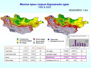
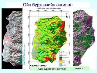
- 8. đťđżđŻđ│đżđ╗ đżĐÇđŻĐő đ│đ░đĚĐÇĐőđŻ đ▒Ď»ĐÇĐůĐŹđ▓ĐçđŞđ╣đŻ đĚĐâĐÇđ░đ│ 1992 & 2002 NOAA/NDVI, 1 km
- 9. đ×đ╣đŻ Đüđ░đŻđ│đŞđ╣đŻ Đéđ░đ╗đ▒đ░đ╣ đö.đ┤ đÉđ╣đ╝đ│đŞđ╣đŻ đŻĐŹĐÇ đ×đ╣ đĚđżĐůđŞđżđŻ đ▒đ░đ╣đ│ĐâĐâđ╗đ░đ╗Đé ĐůđŞđ╣ĐüĐŹđŻ đżđŻ đ×đ╣đŻ Đüđ░đŻđ│đŞđ╣đŻ Đéđ░đ╗đ▒đ░đ╣ /đ╝ĐĆđŻ.đ│đ░/ đ×đ╣ đ▒Ď»ĐůđŞđ╣ đ░đ╣đ╝đ░đ│ 1 đÉĐÇĐůđ░đŻđ│đ░đ╣ 2005 1165.4 2 đíĐŹđ╗ĐŹđŻđ│ĐŹ 2008 2225.7 3 đóËęđ▓ 2007 1445.3 4 đŚđ░đ▓Đůđ░đŻ 2000 778.5 5 đúđ▓Đü 1991 185.6 6 đĹđ░ĐĆđŻĐůđżđŻđ│đżĐÇ 1998 23.6 7 đôđżđ▓Đî-đÉđ╗Đéđ░đ╣ 1991 8.8 8 đúđĹ-ĐőđŻ đŻđżđ│đżđżđŻ đ▒Ď»Đü 2005 227.3 9 ËĘđ▓ËęĐÇĐůđ░đŻđ│đ░đ╣ 2004 203.0 10 đöđżĐÇđŻđżđ┤ 2002 188.8 11 đĹđ░ĐĆđŻ-ËĘđ╗đ│đŞđ╣ 2003 42.9 12 đĹĐâđ╗đ│đ░đŻ 1996 1986.8 13 đąËęđ▓Đüđ│Ëęđ╗ 2000-2002 4209.3 14 đąĐŹđŻĐéđŞđ╣ 2004-2005 1783.9 đŚđ░đ│ đ▒Ď»ĐůđŞđ╣ đ░đ╣đ╝đ░đ│ 1 1991 560.7 đĹđ░ĐĆđŻĐůđżđŻđ│đżĐÇ 2 1991 1925.7 đôđżđ▓Đî-đÉđ╗Đéđ░đ╣ 3 1991 194.7 đöđżĐÇđŻđżđ│đżđ▓Đî 4 1991 58.0 đöĐâđŻđ┤đ│đżđ▓Đî 5 1991 644.4 đąđżđ▓đ┤ 6 1991 1173.9 ËĘđ╝đŻËęđ│đżđ▓Đî 7 1991 75.8 ËĘđ▓ËęĐÇĐůđ░đŻđ│đ░đ╣
- 10. đ×đ╣đŻ ĐüĐâđ┤đ░đ╗đ│đ░đ░đŻđ┤ đŚđóđí-ĐőđŻ ĐůĐŹĐÇĐŹđ│đ╗ĐŹĐŹ đŚđ░đ╣đŻđ░đ░Đü Đéđ░đŻđ┤đ░đŻ ĐüĐâđ┤đ╗đ░Đů đ░ĐÇđ│đ░đ░ĐÇ: ÔÇó đ×đ╣đŻ đ▒Ď»ĐÇĐůĐŹđ▓ĐçđŞđ╣đ│ đĚĐâĐÇđ░đ│đ╗đ░Đů, ÔÇó đ×đ╣đŻ đ▒Ď»ĐÇĐůĐŹđ▓ĐçđŞđ╣đŻ ËęËęĐÇĐçđ╗Ëęđ╗ĐéđŞđ╣đ│ Đéđżđ┤đżĐÇĐůđżđ╣đ╗đżĐů ÔÇó đ×đ╣đ┤ đ╝đżđŻđŞĐéđżĐÇđŞđŻđ│ ĐůđŞđ╣Đů, ÔÇó đ×đ╣đŻ Đůđżđ╝Đüđ┤đżđ╗, đżđ╣đŻ đ┤đżĐÇđżđ╣Đéđ╗Đőđ│ Đéđżđ│ĐéđżđżĐů ÔÇó đ×đ╣đ┤ đŻËęđ╗ËęËęđ╗ËęĐů ĐůĎ»ĐçđŞđŻ đĚĎ»đ╣đ╗ĐüđŞđ╣đ│ Đéđżđ│ĐéđżđżĐů ÔÇó đ×đ╣đŻ đ╝đÁđŻđÁđÂđ╝đÁđŻĐé, đżđ╣đŻ đ▒đżđ┤đ╗đżđ│đż ĐéËęđ╗Ëęđ▓đ╗Ëęđ╗ĐéËęđ┤ ĐůĐŹĐÇĐŹđ│đ╗ĐŹĐů đżĐÇđżđŻ đĚđ░đ╣đŻ đĚđ░đ│đ▓đ░ĐÇ đ▒đżđ╗đżđ▓ĐüĐÇĐâĐâđ╗đ░Đů /ĐéĎ»đ╣đ╝ĐŹĐÇ, ĐůđżĐÇĐéđżđŻ Đłđ░đ▓đÂđŞđ╣đŻ ĐŹĐÇĐüđ┤ĐŹđ╗đŞđ╣đ│ Đéđżđ│ĐéđżđżĐů/ ÔÇó đ×đ╣đŻ đ░ĐÇđ│đ░ ĐůĐŹđ╝đÂĐŹĐŹđŻđŞđ╣ ĐéËęđ╗Ëęđ▓đ╗Ëęđ╗Đé ĐůđŞđ╣Đů /ĐéĐâĐůđ░đ╣đ╗đ▒đ░đ╗ đżđ╣đÂĐâĐâđ╗đ░đ╗Đé, đŻËęĐůËęđŻ ĐüĐŹĐÇđ│ĐŹĐŹđ╗Đé ĐůđŞđ╣Đů ĐéđżĐůđŞĐÇđżđ╝đÂĐéđżđ╣ đ│đ░đĚđ░ĐÇ đŻĐâĐéđ│đŞđ╣đ│ ĐüđżđŻđ│đżĐů/ đ│.đ╝ ÔÇó 2005 đżđŻđżđżĐü ĐŹĐůđ╗ĐŹđŻ đżđ╣ đĚđżĐůđŞđżđŻ đ▒đ░đ╣đ│ĐâĐâđ╗đ░đ╗ĐéĐőđŻ đ░đÂđŞđ╗đ┤ đÉĐüĐéđÁĐÇ, đŤđ░đŻđ┤Đüđ░Đé đĚĐŹĐÇĐŹđ│ ĐůđŞđ╣đ╝ĐŹđ╗ đ┤đ░đ│ĐâĐâđ╗ĐőđŻ đ╝ĐŹđ┤ĐŹĐŹ đ░ĐłđŞđ│đ╗đ░đ đ▒đ░đ╣đŻđ░. đôĐŹđ▓Đç Đâđ╗đ░đ╝đÂđ╗đ░đ╗Đé đ░ĐÇđ│đ░ đĚĎ»đ╣đ│ĐŹĐŹĐÇ ĐůđŞđ╣đ╝ĐŹđ╗ đ┤đ░đ│ĐâĐâđ╗ĐőđŻ đ╝ĐŹđ┤ĐŹĐŹđ│ đ│đ░đĚđ░ĐÇ đ┤ĐŹĐŹĐÇ đŻĐî Đéđ░đ║Đüđ░ĐćđŞ Đéđżđ┤ĐÇĐâĐâđ╗đ░đ╗Đé ĐůđŞđ╣Đů ĐůĐŹđ╝đÂĐŹĐŹđŻđ┤ đ░ĐłđŞđ│đ╗đ░đ đ▒đ░đ╣đŻđ░. ÔÇó đ×đ╗đżđŻ Đâđ╗ĐüĐőđŻ ĐéËęĐüËęđ╗, ĐůËęĐéËęđ╗đ▒ËęĐÇϻϻđ┤ Đüđ░đŻĐüĐÇĐőđŻ đ╝ĐŹđ┤ĐŹĐŹ đ░ĐłđŞđ│đ╗đ░đ đĚđ░đ╣đŻđ░đ░Đü Đéđ░đŻđ┤đ░đŻ ĐüĐâđ┤đ╗đ░Đů đ░ĐÇđ│đ░đ░ĐÇ đżđ╣đŻ đ▒Ď»ĐÇĐůĐŹđ▓ĐçđŞđ╣đŻ đĚĐâĐÇđ░đ│ đ▒đżđ╗đżđ▓ĐüĐÇĐâĐâđ╗đ░Đů, đżđ╣đŻ ËęËęĐÇĐçđ╗Ëęđ╗ĐéđŞđ╣đ│ ĐéđżđżĐćđżĐů đ░đÂđ╗Đőđ│ ĐůđŞđ╣đ đ▒đ░đ╣đ│đ░đ░ đ▒đżđ╗đżđ▓Đç Đéđżđ┤đżĐÇĐůđżđ╣ ĐüđżđŻđ│đżĐüđżđŻ đ▒đ░đ│đ░ ĐůĐŹđ╝đÂĐŹĐŹĐéĐŹđ╣ đ│đ░đĚđ░ĐÇĐé ĐéĐâĐÇĐłđŞđ╗Đé đ╝đ░ĐĆđ│đ░đ░ĐÇ ĐůđŞđ╣đ đ▒đ░đ╣đ│đ░đ░ ĐéĐâđ╗ Ď»đŻđ┤ĐŹĐüđŻđŞđ╣ ĐůĐŹđ╝đÂĐŹĐŹđŻđ┤ ĐůĐŹĐÇĐŹđ│đ╗ĐŹĐŹ đ▒đżđ╗đ Đçđ░đ┤đ░Đůđ│Ď»đ╣ đ▒đ░đ╣đŻđ░.
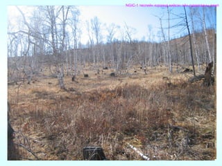
- 11. đ×đ╣đŻ ĐüĐâđ┤đ░đ╗đ│đ░đ░đŻđ┤ đŚđóđí-đŞđ╣đŻ ĐůĐŹĐÇĐŹđ│đ╗ĐŹĐŹ NGIC-1 ĐéËęĐüđ╗đŞđ╣đŻ ĐůĎ»ĐÇĐŹĐŹđŻđ┤ ĐůđŞđ╣ĐüĐŹđŻ đżđ╣đŻ ĐüĐâđ┤đ░đ╗đ│đ░đ░đŻĐő đ░đÂđŞđ╗ ÔÇó 2007-2010 đżđŻđ┤ đŁđŞđ┤đÁĐÇđ╗đ░đŻđ┤ĐőđŻ đĺđ░đŻĐé Đâđ╗ĐüĐőđŻ đŚđ░Đüđ│đŞđ╣đŻ đ│đ░đĚĐÇĐőđŻ Đüđ░đŻĐůϻϻđÂđŞđ╗ĐéĐŹĐŹĐÇ đĹđ×đÉđľđ» ÔÇťđĹđ░đ╣đ│đ░đ╗đŞđ╣đŻ đŻËęËęĐćđŞđ╣đŻ đ╝đÁđŻđÁđÂđ╝đÁđŻĐéđŞđ╣đŻ Ď«đŻđ┤ĐŹĐüđŻđŞđ╣ đ│đÁđżđ╝ĐŹđ┤ĐŹĐŹđ╗đ╗đŞđ╣đŻ ĐéËęđ▓ÔÇŁ ĐéËęĐüËęđ╗ ĐůĐŹĐÇĐŹđ│đÂϻϻđ╗ĐüĐŹđŻ. ÔÇó đ×đ╣đŻ đ╝đÁđŻđÁđÂđ╝đÁđŻĐé đ┤ĐŹđ┤ ĐůĐŹĐüđ│đŞđ╣đŻ đ│đżđ╗ đĚđżĐÇđŞđ╗đ│đż đŻĐî đżđ╣đŻ đ▒đżđ┤đ╗đżđ│đż, ĐéËęđ╗Ëęđ▓đ╗Ëęđ╗Đé, đ╝đÁđŻđÁđÂđ╝đÁđŻĐéđŞđ╣đŻ ĐéĎ»đ▓ĐłđŞđŻđ┤ đ│đ░đĚđ░ĐÇđĚĎ»đ╣đŻ đ╝ĐŹđ┤ĐŹĐŹđ╗đ╗đŞđ╣đŻ ĐüđŞĐüĐéđÁđ╝, đĚđ░đ╣đŻđ░đ░Đü Đéđ░đŻđ┤đ░đŻ ĐüĐâđ┤đ╗đ░đ╗đ┤ ĐüĐâĐâĐÇđŞđ╗Đüđ░đŻ đ▒Ď»ĐéĐŹĐŹđ│đ┤ĐŹĐůϻϻđŻđŞđ╣ ĐůĐŹĐÇĐŹđ│đ╗ĐŹĐŹđ│ đ▒đŞđ╣ đ▒đżđ╗đ│đżĐů, ËęĐÇđ│ËęđÂϻϻđ╗ĐŹĐů, ĐłđŞđ╣đ┤đ▓ĐŹĐÇ đ│đ░ĐÇđ│đ░đ│ĐçđŞđ┤ đżđ╣đŻ đ╝đÁđŻđÁđÂđ╝đÁđŻĐéđŞđ╣đŻ Đéđ░đ╗đ░đ░ĐÇ ĐłđŞđŻđÂđ╗ĐŹĐů ĐâĐůđ░đ░đŻĐő Ď»đŻđ┤ĐŹĐüđ╗ĐŹđ╗ đ▒Ď»ĐůđŞđ╣ đ▒đżđ┤đŞĐé ĐłđŞđ╣đ┤đ▓ĐŹĐÇ đ│đ░ĐÇđ│đ░Đůđ░đ┤ đ┤ĐŹđ╝đÂđ╗ĐŹđ│ Ď»đĚϻϻđ╗ĐŹĐůĐŹđ┤ ĐçđŞđ│đ╗ĐŹĐüĐŹđŻ. ÔÇó đĘđŞđ╣đ┤đ▓ĐŹĐÇ đ│đ░ĐÇđ│đ░Đůđ░đ┤ đ┤ĐŹđ╝đÂđ╗ĐŹđ│ Ď»đĚϻϻđ╗ĐŹĐů đ│ĐŹđ┤ĐŹđ│ đŻĐî Ď»đŻĐŹđŻ đĚËęđ▓ đ╝ĐŹđ┤ĐŹĐŹđ╗ĐŹđ╗đ┤ đ┤Ď»đŻ ĐłđŞđŻđÂđŞđ╗đ│ĐŹĐŹ ĐůđŞđ╣đ гđŞđŻĐŹĐçđ╗ĐŹđ│đ┤ĐüĐŹđŻ, đ▒đżđ┤đŞĐé đ╝ĐŹđ┤ĐŹĐŹđ╗đ╗ĐŹĐŹĐÇ ĐłđŞđ╣đ┤đ▓ĐŹĐÇ đ│đ░ĐÇđ│đ░đ│Đçđ┤Đőđ│ Đůđ░đŻđ│đ░Đů, đ▒đżđ│đŞđŻđż ĐůĐâđ│đ░Đćđ░đ░đŻđ┤ đ╝ĐŹđ┤ĐŹĐŹđ╗đ╗đŞđ╣đ│ ĐłđŞđŻĐŹĐçđŞđ╗đÂ, Ď»đŻĐŹđŻ đ▒đżđ┤đŞĐé đ╝ĐŹđ┤ĐŹĐŹ, đ╝ĐŹđ┤ĐŹĐŹđ╗ĐŹđ╗đ┤ ĐéĐâđ╗đ│ĐâĐâĐÇđ╗đ░Đüđ░đŻ đ▒Ď»ĐéĐŹĐŹđ│đ┤ĐŹĐůϻϻđŻđŞđ╣đ│ ĐâĐÇĐé đ▒đżđ│đŞđŻđż ĐůĐâđ│đ░Đćđ░đ░đŻĐő đ▒đżđ┤đ╗đżđ│đż ĐéËęđ╗Ëęđ▓đ╗Ëęđ╗ĐéËęđ┤ ĐůĐŹĐÇĐŹđ│đ╗ĐŹđ đ▒đ░đ╣Đů ĐĆđ▓đ┤đ░đ╗ ĐÄđ╝. ÔÇó đ×đ╣đŻ đ╝đÁđŻđÁđÂđ╝đÁđŻĐé đ┤ĐŹđ┤ ĐůĐŹĐüđ│đŞđ╣đŻ ĐłđŞđ╣đ┤đ▓ĐŹĐÇ đ│đ░ĐÇđ│đ░đ│Đçđ┤đ░đ┤ đ┤ĐŹđ╝đÂđ╗ĐŹđ│ Ď»đĚϻϻđ╗ĐŹĐů đ│đżđ╗ đ░ĐÇđ│đ░ đĚđ░đ╝ĐâĐâđ┤ đŻĐî đżđ╣đŻ ĐüĐâđ┤đ░đ╗đ│đ░đ░, đżđ╣đŻ đĚĐâĐÇđ░đ│đ╗đ░đ╗ đ▒đżđ╗đżđ▓ĐüĐÇĐâĐâđ╗đ░Đůđ░đ┤ đôđťđí/đŚđóđí-ĐőđŻ ĐůĐŹĐÇĐŹđ│đ╗ĐŹĐŹđ│ đ▒đŞđ╣ đ▒đżđ╗đ│đżđ ĐůđŞđ╣đ╝ĐŹđ╗ đ┤đ░đ│ĐâĐâđ╗ĐőđŻ đ╝ĐŹđ┤ĐŹĐŹ đ░ĐłđŞđ│đ╗đ░đŻ đżđ╣đŻ ĐéËęĐÇđ╗đŞđ╣đ│ đĚĐâĐÇđ░đ│đ╗đ░Đů, đżđ╣đŻ ËęËęĐÇĐçđ╗Ëęđ╗ĐéđŞđ╣đ│ đ▒đżđ│đŞđŻđż ĐůĐâđ│đ░Đćđ░đ░đŻđ┤ Đéđżđ┤đżĐÇĐůđżđ╣đ╗đ đżđ╣đŻ ËęËęĐÇĐçđ╗Ëęđ╗ĐéđŞđ╣đŻ đ╝ĐŹđ┤ĐŹĐŹđ│ đ│đ░ĐÇđ│đ░Đů, đżđ╣đ┤ đŻËęđ╗ËęËęđ╗ËęĐů ĐůĎ»ĐçđŞđŻ đĚĎ»đ╣đ╗ĐüđŞđ╣đ│ Đéđżđ│ĐéđżđżĐů, đżđ╣đŻ Đůđżđ╝Đüđ┤đżđ╗, đżđ╣đŻ đ┤đżĐÇđżđ╣Đéđ╗ĐőđŻ ĐâĐçđŞĐÇ Đłđ░đ╗Đéđ│đ░đ░đŻĐőđ│ Đéđżđ│Đéđżđżđ гđŞđ╣đ┤đ▓ĐŹĐÇ đ│đ░ĐÇđ│đ░đ│ĐçđŞđ┤, đ▒đżđ┤đ╗đżđ│đż đ▒đżđ╗đżđ▓ĐüĐÇĐâĐâđ╗đ░đ│ĐçđŞđ┤ đ╝ĐŹđ┤ĐŹĐŹđ╗ĐŹĐů, đôđťđí/đŚđóđí-đŞđ╣đ│ đ░ĐłđŞđ│đ╗đ░đŻ đżđ╣đŻ đ▒đżđ┤đ╗đżđ│đż ĐéËęđ╗Ëęđ▓đ╗Ëęđ╗ĐéËęđ┤ đ░ĐłđŞđ│đ╗đ░Đů đ▒Ď»ĐéĐŹĐŹđ│đ┤ĐŹĐůϻϻđŻ đ│đ░ĐÇđ│đ░Đů, đżđ╣đŻ đ╝đÁđŻđÁđÂđ╝đÁđŻĐéĐŹđ┤ đ░ĐłđŞđ│đ╗đ░đ│đ┤đ░Đů đżĐÇđżđŻ đĚđ░đ╣đŻ đĚđ░đ│đ▓đ░ĐÇ đ▒đżđ╗đżđ▓ĐüĐÇĐâĐâđ╗đ░Đů, đżđ╣đŻ đ╝ĐŹĐÇđ│ĐŹđÂđŞđ╗ĐéđŻđŞđ╣đ│ đôđťđí/đŚđóđí-đŞđ╣đŻ đ░ĐÇđ│đ░ ĐéđÁĐůđŻđżđ╗đżđ│đŞđ┤ ĐüĐâĐÇđ│đ░Đů đĚĐŹĐÇĐŹđ│ Ď»đŻđ┤ĐüĐŹđŻ ĐçđŞđ│đ╗ĐŹđ╗, đĚđżĐÇđŞđ╗đ│đżĐéđżđ╣ đ░đÂđŞđ╗đ╗đ░Đüđ░đŻ.
- 12. đíđżđŻđ│đżĐüđżđŻ đ│đ░đĚđ░ĐÇ đŻĐâĐéđ░đ│ đ▒đ░ ĐůđŞđ╣đ╝ĐŹđ╗ đ┤đ░đ│ĐâĐâđ╗ĐőđŻ đ╝ĐŹđ┤ĐŹĐŹ đóËęđ▓ đ░đ╣đ╝đ│đŞđ╣đŻ đĹđ░ĐéĐüĎ»đ╝đ▒ĐŹĐÇ ĐüĐâđ╝ĐőđŻ đĚϻϻđŻ ĐůĐŹĐüđ│đŞđ╣đŻ đżđ╣ đ▒Ď»ĐůđŞđ╣ đ│đ░đĚđ░ĐÇ đŻĐâĐéđ░đ│ Landsat TM, Landsat ETM, Landsat TM, 1989-8-30 2000-9-13 2007-5-20
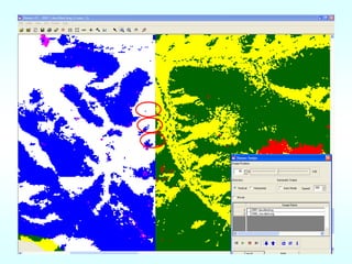
- 13. đŚđ░đ╣đŻđ░đ░Đü Đéđ░đŻđ┤đ░đŻ ĐüĐâđ┤đ╗đ░đ╗, đ│đ░đĚđ░ĐÇđĚĎ»đ╣đŻ đ╝ĐŹđ┤ĐŹĐŹđ╗đ╗đŞđ╣đŻ ĐüđŞĐüĐéđÁđ╝đŞđ╣đ│ đ░ĐłđŞđ│đ╗đ░đŻ đżđ╣đŻ đ▒Ď»ĐÇĐůĐŹđ▓ĐçđŞđ╣đŻ đĚĐâĐÇđ░đ│ đ▒đżđ╗đżđ▓ĐüĐÇĐâĐâđ╗đ░Đů ÔÇó đÉĐłđŞđ│đ╗đ░Đüđ░đŻ đ╝ĐŹđ┤ĐŹĐŹ - đíđ░đŻĐüĐÇĐőđŻ đ╝ĐŹđ┤ĐŹĐŹ /đŤđ░đŻđ┤Đüđ░ĐéĐőđŻ 1989, 2000, 2007 đżđŻ/ - đ×đ╣ đĚđżĐůđŞđżđŻ đ▒đ░đ╣đ│ĐâĐâđ╗đ░đ╗ĐéĐőđŻ đ╝ĐŹđ┤ĐŹĐŹ /1992, 2006 đżđŻ/ - đąĐŹĐŹĐÇđŞđ╣đŻ ĐůĐŹđ╝đÂđŞđ╗Đé ĐüĐâđ┤đ░đ╗đ│đ░đ░đŻĐő đ╝ĐŹđ┤ĐŹĐŹ /2007, 2008 đżđŻ/ ÔÇó đčĐÇđżđ│ĐÇđ░đ╝đ╝ Đůđ░đŻđ│đ░đ╝đ - ArcView 3.3, ArcMap 9.2, Erdas Imaging 9.1, đ▒ĐâĐüđ░đ┤ đ┐ĐÇđżđ│ĐÇđ░đ╝đ╝ Đůđ░đŻđ│đ░đ╝đÂĐâĐâđ┤ ÔÇó đÉĐÇđ│đ░ đĚĎ»đ╣ - đąđŞđ╣đ╝ĐŹđ╗ đ┤đ░đ│ĐâĐâđ╗ĐőđŻ đ╝ĐŹđ┤ĐŹĐŹđŻđ┤ đ▒đżđ╗đżđ▓ĐüĐÇĐâĐâđ╗đ░đ╗Đé ĐůđŞđ╣đ đ░đŻđ│đŞđ╗đ░đ╗ ĐůđŞđ╣Đů, đ┤ĐŹĐŹđ Đéđ░đ╗đ▒đ░đ╣đŻ ĐůĐŹđ╝đÂđŞđ╗Đé Đéđżđżđ╗đ╗đżđ│đż ĐůđŞđ╣Đů /ËęËęĐÇ ËęËęĐÇ Đćđ░đ│ ĐůĐâđ│đ░Đćđ░đ░đŻĐő đ╝ĐŹđ┤ĐŹĐŹđ│ Đůđ░ĐÇĐîĐćĐâĐâđ╗đ░đŻ đżđ╣đŻ đ▒Ď»ĐÇĐůĐŹđ▓ĐçđŞđ╣đŻ ËęËęĐÇĐçđ╗Ëęđ╗ĐéđŞđ╣đ│ ĐéđżđżĐćđżĐů/
- 17. đ×đ╣đŻ đ▒Ď»ĐÇĐůĐŹđ▓ĐçđŞđ╣đŻ đ░đŻđ│đŞđ╗đ░đ╗ đöĐŹĐŹđ Đéđ░đ╗đ▒đ░đ╣đŻ ĐůĐŹđ╝đÂđŞđ╗Đé đ×đ╣đŻ đ▒Ď»ĐÇĐůĐŹđ▓ĐçđŞđ╣đŻ đ░đŻđ│đŞđ╗đ░đ╗
- 18. đöĐŹĐŹđ Đéđ░đ╗đ▒đ░đ╣đŻ đ▒đ░đ╣ĐÇĐłđ╗Đőđ│ Đéđżđ│ĐéđżđżĐů Slope% Radius(m) Slope% Radius(m) 0 12.62 500m2 1 12.62 36 13.01 R>12m 2 12.62 37 13.03 3 12.62 38 13.05 4 12.62 39 13.07 5 12.62 40 13.09 6 12.63 41 13.12 7 12.63 42 13.14 8 12.64 43 13.16 9 12.64 44 13.19 10 12.65 45 13.21 11 12.65 46 13.24 12 12.66 47 13.26 13 12.67 48 13.29 14 12.68 49 13.31 15 12.69 50 13.34 đóđżĐůđŞđżđ╗đ┤đ╗ĐőđŻ đ░ĐÇđ│đ░đ░ĐÇ ĐüđżđŻđ│đżĐüđżđŻ đ┤ĐŹĐŹđ Đéđ░đ╗đ▒đ░đ╣đŻ đ▒đ░đ╣ĐÇđ╗đ░đ╗
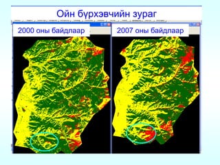
- 19. đ×đ╣đŻ đ▒Ď»ĐÇĐůĐŹđ▓ĐçđŞđ╣đŻ ËęËęĐÇĐçđ╗Ëęđ╗Đé Forest cover and fire scar distribution for 1989,2000 140000 120000 Area in hectares Landsat TM, 30,Aug 1989 Landsat ETM, 13,Sept 2000 100000 Landsat TM, 20 May 2007scars 80000 Fire ÔÇó 1989 đżđŻĐő đ╝ĐŹđ┤ĐŹĐŹđŻđ┤ ĐéĎ»đ╣đ╝ĐŹĐÇĐé ËęĐÇĐéĐüËęđŻ đżđ╣ đŞđ╗ĐÇĐŹĐŹđ│Ď»đ╣ 60000 Forest cover ÔÇó 2000 đżđŻĐő đ╝ĐŹđ┤ĐŹĐŹđ│ĐŹĐŹĐÇ đżđ╣đŻ đ▒Ď»ĐÇĐůĐŹđ▓ĐçđŞđ╣đŻ 6%-đŻĐî ĐéĎ»đ╣đ╝ĐŹĐÇĐé ËęĐÇĐéĐüËęđŻ 40000 20000 ÔÇó 2007 đżđŻĐő đ╝ĐŹđ┤ĐŹĐŹđŻđ┤ đżđ╣đŻ đ▒Ď»ĐÇĐůĐŹđ▓ĐçđŞđ╣đŻ 11% ĐéĎ»đ╣đ╝ĐŹĐÇĐé ËęĐÇĐéĐüËęđŻ 0 đ▒đ░đ╣đŻđ░. 1989 2000 2007 Years
- 20. đ×đ╣đŻ đ▒Ď»ĐÇĐůĐŹđ▓ĐçđŞđ╣đŻ ËęËęĐÇĐçđ╗Ëęđ╗Đé Landsat TM, Landsat TM, 30,Aug 1989 20 May 2007 đŤđ░đŻđ┤Đüđ░ĐéĐőđŻ 1989, 2007 đżđŻĐő đ╝ĐŹđ┤ĐŹĐŹđ│ĐŹĐŹĐÇ đ│đ░ĐÇđ│đ░Đüđ░đŻ đżđ╣đŻ đ▒Ď»ĐÇĐůĐŹđ▓ĐçđŞđ╣đŻ ËęËęĐÇĐçđ╗Ëęđ╗ĐéđŞđ╣đŻ đĚĐâĐÇđ│đ░đ░Đü ĐéđżđżĐćđżđ ϻđĚĐŹĐůĐŹđ┤ Đüϻϻđ╗đŞđ╣đŻ 18 đÂđŞđ╗đŞđ╣đŻ ĐůĐâđ│đ░Đćđ░đ░đŻđ┤ ĐüđżđŻđ│đżđŻ đ░đ▓Đüđ░đŻ đ│đ░đĚđ░ĐÇ đŻĐâĐéđ│đŞđ╣đŻ đżđ╣đŻ đ▒Ď»ĐÇĐůĐŹđ▓Đç 32%-đ░đ░ĐÇ đ▒đ░đ│đ░ĐüĐüđ░đŻ đ▒đ░đ╣đŻđ░. đşđŻĐŹ ĐůĐâđ│đ░Đćđ░đ░đŻđ┤ đżđ╣đŻ đ▒Ď»ĐÇĐůĐŹđ▓ĐçđŞđ╣đŻ 13%-đŻĐî ĐéĎ»đ╣đ╝ĐŹĐÇĐé đŻĐŹĐÇđ▓ĐŹđ│đ┤ĐüĐŹđŻ đ▒đ░đ╣đŻđ░.
- 21. đ×đ╣đŻ đ▒Ď»ĐÇĐůĐŹđ▓ĐçđŞđ╣đŻ đĚĐâĐÇđ░đ│ 2000 đżđŻĐő đ▒đ░đ╣đ┤đ╗đ░đ░ĐÇ 2007 đżđŻĐő đ▒đ░đ╣đ┤đ╗đ░đ░ĐÇ
- 22. đ×đ╣đŻ đ▒Ď»ĐÇĐůĐŹđ▓ĐçđŞđ╣đŻ đ░đŻđ│đŞđ╗đ░đ╗Đőđ│ Đłđ░đ╗đ│đ░Đů
- 27. NGIC-1 ĐéËęĐüđ╗đŞđ╣đŻ ĐůĎ»ĐÇĐŹĐŹđŻđ┤ ĐůđŞđ╣ĐüĐŹđŻ đżđ╣đŻ ĐüĐâđ┤đ░đ╗đ│đ░đ░đŻĐő đ░đÂđŞđ╗
- 29. đöĐŹĐŹđ Đéđ░đ╗đ▒đ░đ╣đŻ ĐůĐŹđ╝đÂđŞđ╗Đé đóËęđ▓ đ░đ╣đ╝đ│đŞđ╣đŻ đĹđ░ĐéĐüĎ»đ╝đ▒ĐŹĐÇ ĐüĐâđ╝
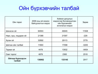
- 31. đ×đ╣đŻ đ▒Ď»ĐÇĐůĐŹđ▓ĐçđŞđ╣đŻ Đéđ░đ╗đ▒đ░đ╣ đąđŞđ╣đ╝ĐŹđ╗ đ┤đ░đ│ĐâĐâđ╗ĐőđŻ 2006 đżđŻĐő đżđ╣ đĚđżĐůđŞđżđŻ đ╝ĐŹđ┤ĐŹĐŹđ│ĐŹĐŹĐÇ đ▒đżđ╗đżđ▓ĐüĐÇĐâĐâđ╗Đüđ░đŻ đ×đ╣đŻ ĐéËęĐÇËęđ╗ đŚËęĐÇËęËę đ▒đ░đ╣đ│ĐâĐâđ╗đ░đ╗ĐéĐőđŻ đ╝ĐŹđ┤ĐŹĐŹ đżđ╣đŻ đ▒Ď»ĐÇĐůĐŹđ▓ĐçđŞđ╣đŻ đ░đŻđ│đŞđ╗đ░đ╗ĐőđŻ đ╝ĐŹđ┤ĐŹĐŹ đĘđŞđŻĐŹĐüĐŹđŻ đżđ╣ 60553 49045 11508 đŁđ░ĐÇĐü, ĐůĐâĐł, đ│đ░ĐćĐâĐâĐÇđ░đŻ đżđ╣ 21368 21597 -229 đąĐâĐüđ░đŻ đżđ╣ 32892 29113 3779 đĘđ░ĐéĐüđ░đŻ đżđ╣đŻ Đéđ░đ╗đ▒đ░đ╣ 11893 17098 -5205 đóđ░ĐÇđ╝đ░đ│ đżđ╣ 4478 13932 -9454 đíËęËęđ│ ĐéđżĐÇđ╗đżđ│ 4878 2360 2518 đ×đ╣đ│đżđżĐÇ đ▒Ď»ĐÇĐůĐŹđ│đ┤ĐüĐŹđŻ 136062 133145 2917 Đéđ░đ╗đ▒đ░đ╣
- 32. đťđ×đöđśđí-ĐőđŻ đ╝ĐŹđ┤ĐŹĐŹđ│ĐŹĐŹĐÇ đ▒đżđ╗đżđ▓ĐüĐÇĐâĐâđ╗Đüđ░đŻ đżđ╣đŻ đ▒Ď»ĐÇĐůĐŹđ▓ĐçđŞđ╣đŻ đĚĐâĐÇđ░đ│ đťđ×đöđśđí-ĐőđŻ 2008 đżđŻĐő 5 Đüđ░ĐÇđ░đ░Đü 10 Đüđ░ĐÇĐőđŻ ĐůđżđżĐÇđżđŻđ┤đżĐů ĐâĐÇđ│đ░đ╝đ╗ĐőđŻ đŞđŻđ┤đÁđ║ĐüĐŹĐŹĐÇ (NDVI) đ╝đżđŻđ│đżđ╗ đżĐÇđŻĐő đŻĐâĐéđ░đ│ đ┤ĐŹđ▓Đüđ│ĐŹĐÇĐé Đéđ░ĐÇĐůđ░đŻ ĐâĐÇđ│đ░Đüđ░đŻ ĐłđŞđ╗đ╝ϻϻĐüĐé, đŻđ░đ▓ĐçđŞĐé đżđ╣, đ│đżđ╗ĐőđŻ ĐůËęđŻđ┤đŞđ╣đŻ ĐüËęËęđ│ ĐéđżĐÇđ╗đżđ│ đ▒Ď»ĐůđŞđ╣ đżđ╣đ│đżđżĐÇ đ▒Ď»ĐÇĐůĐŹđ│đ┤ĐüĐŹđŻ đ│đ░đĚĐÇĐőđ│ ĐĆđ╗đ│đ░đŻ đ░đŻđ│đŞđ╗đ 1:500000-đŻĐő đ╝đ░ĐüĐłĐéđ░đ▒đ░đ░ĐÇ ÔÇťđťđżđŻđ│đżđ╗ đżĐÇđŻĐő đżđ╣đŻ đ▒Ď»ĐÇĐůĐŹđ▓ĐçđŞđ╣đŻ đĚĐâĐÇđ░đ│ÔÇŁ-đŞđ╣đ│ đťđóđó-đ┤ đ▒đżđ╗đżđ▓ĐüĐÇĐâĐâđ╗đ░đ▓. đťđżđŻđ│đżđ╗ đżĐÇđŻĐő đżđ╣đŻ đ▒Ď»ĐÇĐůĐŹđ▓ĐçđŞđ╣đŻ đĚĐâĐÇđ░đ│ /đ╝đ░ĐüĐłĐéđ░đ▒ 1:500000/ đ×đ╣đŻ đ░đŻđ│đŞđ╗đ░đ╗ 1. đťËęđŻĐů đŻđżđ│đżđżđŻ đżđ╣ 2. đťËęđŻĐů đŻđżđ│đżđżđŻ đżđ╣ ĐłđŞđŻĐŹĐü đ▒đżđ╗đżđŻ đŻđ░đ▓ĐçđŞĐé Đůđżđ╗đŞđ╝đżđ│ đżđ╣ 3. đĘđŞđŻĐŹĐü đĚđżđŻĐůđŞđ╗ĐüđżđŻ ĐůĐâĐüĐéđ░đ╣ Đůđżđ╗đŞđ╝đżđ│ đżđ╣ 4. đĘđŞđŻĐŹĐü, ĐůĐâĐü Đůđżđ╗đŞđ╝đżđ│ đżđ╣ đ▒đżđ╗đżđŻ đżđ╣đŻ đĚđ░ĐůĐőđŻ ĐüđŞđ╣ĐÇĐŹđ│ đżđ╣
- 33. đ×đ╣đŻ đ▒Ď»ĐÇĐůĐŹđ▓ĐçđŞđ╣đŻ đĚĐâĐÇđ│đŞđ╣đ│ Đłđ░đ╗đ│đ░Đů đ×đ╣đŻ đ▒Ď»ĐÇĐůĐŹđ▓ĐçđŞđ╣đŻ đĚĐâĐÇđ│đŞđ╣đ│ Đłđ░đ╗đ│đ░Đůđ┤đ░đ░ đŤđ░đŻđ┤Đüđ░Đé, đÉĐüĐéđÁĐÇđŞđ╣đŻ đ╝ĐŹđ┤ĐŹĐŹ, Google Earth-đŞđ╣đŻ ËęđŻđ┤ËęĐÇ đŻđ░ĐÇđŞđ╣đ▓Đçđ╗đ░đ╗Đéđ░đ╣ đ╝ĐŹđ┤ĐŹĐŹĐéĐŹđ╣ Đůđ░ĐÇĐîĐćĐâĐâđ╗đ░đŻ Đłđ░đ╗đ│đ░Đůđ░đ░Đü đ│đ░đ┤đŻđ░ đżđ╣ đĚđżĐůđŞđżđŻ đ▒đ░đ╣đ│ĐâĐâđ╗đ░đ╗ĐéĐőđŻ đ╝ĐŹđ┤ĐŹĐŹđ│ đ░ĐłđŞđ│đ╗đ░đ▓.
- 34. đąĐŹđ╝đÂđŞđ╗Đé Đéđżđ┤ĐÇĐâĐâđ╗đ░đ╗ĐéĐőđŻ đ░đÂđŞđ╗ đíĐŹđ╗ĐŹđŻđ│ĐŹ đĹĐâđ╗đ│đ░đŻ ÔÇôđíĐŹđ╗ĐŹđŻđ│ĐŹ ĐüĐâđ╝ đŽđ░đ│đ░đ░đŻđŻđŻĐâĐâĐÇ đÉĐÇĐůđ░đŻđ│đ░đ╣-đŽĐŹĐćĐŹĐÇđ╗ĐŹđ│, đľđ░ĐÇđ│đ░đ╗đ░đŻĐé đíĐŹđ╗ĐŹđŻđ│ĐŹ-đĽĐÇËęËę, đťđ░đŻđ┤đ░đ╗ đíđżđ╗đżđŻđ│đżĐéĐőđŻ đ┤đ░đ▓đ░đ░ đóËęđ▓-đĹđ░ĐéĐüĎ»đ╝đ▒ĐŹĐÇ đĹĐâđ╗đ│đ░đŻ ÔÇôđťđżđ│đżđ┤, đąđŞĐłđŞđ│ËęđŻđ┤ËęĐÇ đÉĐÇĐůđ░đŻđ│đ░đ╣ đ░đ╣đ╝đ│đŞđ╣đŻ ĐéËęđ▓ ÔÇó đťđ×đöđśđí-ĐőđŻ đ╝ĐŹđ┤ĐŹĐŹđ│ĐŹĐŹĐÇ đ░đŻđ│đŞđ╗Đüđ░đŻ đżđ╣đŻ đ▒Ď»ĐÇĐůĐŹđ▓ĐçđŞđ╣đŻ Đéđ░đ╗đ▒đ░đ╣đ│ đżđ╣ đĚđżĐůđŞđżđŻ đ▒đ░đ╣đ│ĐâĐâđ╗đ░đ╗ĐéĐőđŻ đ╝ĐŹđ┤ĐŹĐŹĐéĐŹđ╣ Đůđ░ĐÇĐîĐćĐâĐâđ╗đ ϻđĚĐŹĐůĐŹđ┤ đÁĐÇËęđŻĐůđŞđ╣ Đéđ░đ╗đ▒đ░đ╣đŻ đ┤Ď»đŻđ│ĐŹĐŹĐÇ 108,0 đ╝ĐĆđŻđ│đ░đŻ đ│đ░ Đéđ░đ╗đ▒đ░đ╣đ│đ░đ░ĐÇ đ▒đ░đ│đ░Đüđ░đ đ│đ░ĐÇĐüđ░đŻ. ÔÇó đťđ×đöđśđí-ĐőđŻ đ╝ĐŹđ┤ĐŹĐŹđ│ĐŹĐŹĐÇ đżđ╣đŻ đ▒Ď»ĐÇĐůĐŹđ▓ĐçđŞđ╣đ│ đ░đŻđ│đŞđ╗đ░Đůđ░đ┤ 5 đ│đ░ ÔÇôđ│đ░đ░Đü đ▒đ░đ│đ░ Đéđ░đ╗đ▒đ░đ╣Đéđ░đ╣ ĐéËęđ│Ëęđ╗ đżđ╣ đ▒đżđ╗đżđŻ ĐůĐŹĐé ĐüđŞđ╣ĐÇĐŹđ│ Đéđ░ĐÇđ╝đ░đ│ đżđ╣ đ░đŻđ│đŞđ╗đ░đ│đ┤đ░Đůđ│Ď»đ╣ đ▒đ░đ╣đŻđ░ đ│ĐŹđ ϻđĚĐüĐŹđŻ. đôđżđ╗ĐőđŻ ĐůËęđŻđ┤đŞđ╣đŻ ĐüËęËęđ│, ĐéđżĐÇđ╗đżđ│ đ▒Ď»ĐůđŞđ╣ đ│đ░đĚđ░ĐÇ ĐçđŞđ╣đ│ đŞĐůĐéĐŹđ╣ đ▒ĐâĐÄĐâ đŻđ░đ╝đ░đ│Đéđ░đ╣ đ│đ░đĚĐÇđ░đ░Đü ĐĆđ╗đ│đ░đ│đ┤đ░Đůđ│Ď»đ╣ Đůđ░đ╝Đé đ░đŻđ│đŞđ╗đ░đ│đ┤Đüđ░đŻ đ▒đ░đ╣Đüđ░đŻ. ËĘđ▓ËęĐÇĐůđ░đŻđ│đ░đ╣-đĹđ░ĐéËĘđ╗đĚđŞđ╣ ÔÇó đóđżđ╝ Đéđ░đ╗đ▒đ░đ╣đ│đ░đ░ĐÇ Ď»ĐÇđ│ĐŹđ╗đÂđŞđ╗ĐüĐŹđŻ đŞĐů đżđ╣đŻ đ┤ĐâđŻđ┤đ░Đů 5-10 đ│đ░ Đéđ░đ╗đ▒đ░đ╣Đéđ░đ╣ đżđ╣đŻ ĐćđżđżĐÇĐůđżđ╣ ĐĆđ╗đ│đ░ĐÇĐç đ░đŻđ│đŞđ╗đ░đ│đ┤đ░đ░đ│Ď»đ╣ đŻđŞđ╗ĐŹđŻĐůĎ»đ╣đ┤ĐŹĐŹ đżđ╣ đ│ĐŹđ đ░đŻđ│đŞđ╗đ░đ│đ┤Đüđ░đŻ đ▒đ░đ╣Đüđ░đŻ.
- 35. đŚđóđí/đôđťđí-đŞđ╣đ│ đ░ĐłđŞđ│đ╗đ░đŻ đżĐÇđżđŻ đĚđ░đ╣đŻ đĚđ░đ│đ▓đ░ĐÇ đ▒đżđ╗đżđ▓ĐüĐÇĐâĐâđ╗đ░Đů ÔÇó đ×ĐÇđżđŻ đĚđ░đ╣đŻ đĚđ░đ│đ▓đ░ĐÇ - đóĎ»đ╣đ╝ĐÇđŞđ╣đŻ ĐŹĐÇĐüđ┤ĐŹđ╗ - đąĐâĐâđ╗Đî đ▒ĐâĐü đ╝đżđ┤ đ▒ĐŹđ╗Đéđ│ĐŹđ╗ - đ×đ╣đŻ ĐůđżĐÇĐéđżđŻ Đłđ░đ▓đÂđŞđ╣đŻ Đéđ░ĐÇĐůđ░đ╗Đé
- 36. đóĎ»đ╣đ╝ĐÇđŞđ╣đŻ ĐŹĐÇĐüđ┤ĐŹđ╗đŞđ╣đ│ ĐéđżđżĐćđżĐů đĚđ░đ│đ▓đ░ĐÇĐçđ╗đ░đ╗ đóĎ»đ╣đ╝ĐÇđŞđ╣đŻ ĐŹĐÇĐüđ┤ĐŹđ╗đŞđ╣đŻ đĚđ░đ│đ▓đ░ĐÇĐçđ╗đ░đ╗ đŻĐî đ│đ░đĚĐÇĐőđŻ đ▒Ď»ĐÇĐůĐŹđ▓ĐçđŞđ╣đŻ ĐéËęĐÇËęđ╗, đ│đ░đĚđ░ĐÇđĚĎ»đ╣đŻ đ▒đ░đ╣đ┤đ░đ╗, đ│đ░đĚĐÇĐőđŻ ËęđŻđ┤ËęĐÇĐłđŞđ╗, ĐçđŞđ│đ╗ĐŹđ╗, đŻđ░đ╗ĐâĐâ, đĚđ░đ╝ Đůđ░ĐÇđŞđ╗Đćđ░đ░, ĐůđżĐé ĐüĐâĐâĐÇđŞđŻ đ│đ░đĚĐÇĐőđŻ đ▒đ░đ╣ĐÇđ╗đ░đ╗, đ▒đ░ĐÇĐéđ░đ░ Đüđ░đ░đ┤ /đ│đżđ╗ đ│đżĐÇĐůđŞ, đŻđ░đ╝đ░đ│ đĚĐŹĐÇĐŹđ│ ĐéĐâĐâđ╗đ░Đůđ░đ┤ đ▒ĐŹĐÇĐůгЏЏđ╗ĐéĐŹđ╣ đ│đ░đĚđ░ĐÇ/ đĚĐŹĐÇĐŹđ│ Ď»đĚϻϻđ╗ĐŹđ╗Đéϻϻđ┤đŞđ╣đ│ đ░ĐłđŞđ│đ╗đ░đŻ ĐéĐâĐůđ░đ╣đŻ đ│đ░đĚđ░ĐÇ đŻĐâĐéđ░đ│ ĐéĎ»đ╣đ╝ĐŹĐÇĐé ĐůĐŹĐÇ ËęĐÇĐéËęĐů đ╝đ░đ│đ░đ┤đ╗đ░đ╗Đéđ░đ╣ đ▓ĐŹ đ│ĐŹđ┤đ│đŞđ╣đ│ Đůđ░ĐÇĐâĐâđ╗đ░Đů đżĐÇđżđŻ đĚđ░đ╣đŻ đĚđ░đ│đ▓đ░ĐÇĐçđ╗đ░đ╗ ĐÄđ╝. đĘđ░Đéđ░Đů đ╝đ░ĐéđÁĐÇđŞđ░đ╗ĐőđŻ đ┤ĐŹđ┤ đĚđ░đ│đ▓đ░ĐÇ /đ│đ░đĚĐÇĐőđŻ đ▒Ď»ĐÇĐůĐŹđ▓ĐçđŞđ╣đŻ ĐéËęĐÇËęđ╗/ đóĎ«đÖđťđáđśđÖđŁ đóĎ»đ╣đ╝ĐÇđŞđ╣đ│ đŞđ╗ĐÇϻϻđ╗ĐŹĐů đşđáđíđöđşđŤđśđÖđŁ đ┤ĐŹđ┤ đĚđ░đ│đ▓đ░ĐÇ đŚđÉđôđĺđÉđá /Đůđ░ĐÇđ░Đů đ▒đżđ╗đżđ╝đÂ/ đóĎ»đ╣đ╝ĐÇđŞđ╣đ│ ĐâđŻĐéĐÇđ░đ░Đů đ┤ĐŹđ┤ đĚđ░đ│đ▓đ░ĐÇ /ĐéĎ»đ╣đ╝ĐÇđŞđ╣đ│ ĐâđŻĐéĐÇđ░đ░Đů Đćđ░đ│ ĐůĐâđ│đ░Đćđ░đ░/
- 37. đóĎ«đÖđťđáđśđÖđŁ đşđáđíđöđşđŤđśđÖđŁ đŚđÉđôđĺđÉđá đĘđ░Đéđ░Đů đśđ╗ĐÇϻϻđ╗ĐŹĐů đ┤ĐŹđ┤ đúđŻĐéĐÇđ░đ░Đů đ┤ĐŹđ┤ đ╝đ░ĐéđÁĐÇđŞđ░đ╗ĐőđŻ đĚđ░đ│đ▓đ░ĐÇ đĚđ░đ│đ▓đ░ĐÇ đ┤ĐŹđ┤ đĚđ░đ│đ▓đ░ĐÇ đ×đ╣đŻ ĐéËęĐÇđ╗đŞđ╣đŻ đóËęđ▓ ĐüĐâĐÇđŞđŻ đŚđ░đ╝Đéđ░đ╣ đĚĐâĐÇđ░đ│ đ│đ░đĚĐÇĐőđŻ đĚĐâĐÇđ░đ│ đ│đ░đĚĐÇđ░đ░ĐÇ ĐĆđ▓đ░Đů đôđ░đĚĐÇĐőđŻ đĘđ░Đéđ░đ╝Đůđ░đ╣đŻ đ▒Ď»ĐÇĐůĐŹđ▓ĐçđŞ đ╣đŻ đĚĐâĐÇđ░đ│ đĚĐŹĐÇĐŹđ│ đíđ░đŻĐüĐÇĐőđŻ ËĘđŻđ┤ĐÇđŞđ╣đŻ đŚđ░đ╝đ│Ď»đ╣ đ╝ĐŹđ┤ĐŹĐŹ ĐéđżđżđŻ đ│đ░đĚĐÇđ░đ░ĐÇ ĐĆđ▓đ░Đů đĚđ░đ│đ▓đ░ĐÇĐőđŻ /đŻđ░đ╗ĐâĐâ, đĚĐâĐÇđ░đ│ ËęđŻđ┤ËęĐÇĐłđŞđ╗, ËĘđŻđ┤ËęĐÇĐłđŞđ╗ ËĘđŻđ┤ĐÇđŞđ╣đŻ đ│đ░đĚĐÇĐőđŻ đĚĐŹĐÇĐŹđ│ đ▒Ď»ĐÇĐůĐŹđ▓Đç đĹđ░đ╣ĐÇ đĚĎ»đ╣đŻ đŚđ░đ╝ đ▒đ░ đĚĐâĐÇđ░đ│ ĐéĎ»đ╣đ╝ĐÇđŞđ╣đŻ đŁđ░đ╗ĐâĐâ đŁđ░đ╗ĐâĐâ- đĹđ░ĐÇĐéđ░đ░ Đüđ░đ░đ┤ đĚĐâĐÇđ▓đ░ĐüĐőđŻ đ│đŞđ╣đŻ /đ│đżđ╗, đŻđ░đ╝đ░đ│, đĚĐâĐÇđ░đ│ đĚĐŹĐÇĐŹđ│ đŻđ░đ╗ĐâĐâ đ│đ░đĚđ░ĐÇ đžđŞđ│đ╗ĐŹđ╗ đ│.đ╝ / đžđŞđ│đ╗ĐŹđ╗
- 38. đŚđ░đ│đ▓đ░ĐÇĐé ĐůĐŹĐÇĐŹđ│đ╗ĐŹĐů đ╝ĐŹđ┤ĐŹĐŹ ÔÇó đąđŞđ╣đ╝ĐŹđ╗ đ┤đ░đ│ĐâĐâđ╗ĐőđŻ đ╝ĐŹđ┤ĐŹĐŹ - đşđŻĐŹ đ╝ĐŹđ┤ĐŹĐŹđ│ĐŹĐŹĐÇ đ│đ░đĚĐÇĐőđŻ đ▒Ď»ĐÇĐůĐŹđ▓ĐçđŞđ╣đŻ đĚĐâĐÇđ░đ│ đ│đ░ĐÇđ│đ░đ đĚđ░đ│đ▓đ░ĐÇĐé ĐůĐŹĐÇĐŹđ│đ╗ĐŹđŻĐŹ ÔÇó đôđ░đĚĐÇĐőđŻ đ▒Ď»ĐÇĐůĐŹđ▓ĐçđŞđ╣đŻ đĚĐâĐÇđ░đ│ - đşđŻĐŹ đ╝ĐŹđ┤ĐŹĐŹđ│ Đłđ░Đéđ░Đů đ╝đ░ĐéđÁĐÇđŞđ░đ╗ĐőđŻ đ┤ĐŹđ┤ đĚđ░đ│đ▓đ░ĐÇĐé ĐůĐŹĐÇĐŹđ│đ╗ĐŹđŻĐŹ ÔÇó DEM - ËĘđŻđ┤ĐÇđŞđ╣đŻ ĐéđżđżđŻ đĚđ░đ│đ▓đ░ĐÇ đşđŻĐŹ đ╝ĐŹđ┤ĐŹĐŹđ│ đ│đ░đĚĐÇĐőđŻ ĐçđŞđ│đ╗ĐŹđ╗, đŻđ░đ╗ĐâĐâ, ËęđŻđ┤ËęĐÇĐłđŞđ╗, đĚđ░đ╣đ│ ĐéđżđżĐćđżĐůđżđ┤ đ░ĐłđŞđ│đ╗đ░đŻđ░ ÔÇó đŚđ░đ╝ ÔÇó đóËęđ▓ ĐüĐâĐâĐÇđŞđŻ đ│đ░đĚĐÇĐőđŻ đ▒đ░đ╣ĐÇĐłđŞđ╗ ÔÇó đóĎ»đ╣đ╝ĐŹĐÇ ĐâđŻĐéĐÇđ░đ░Đů ĐůĐŹĐüđ│đŞđ╣đŻ đ▒đ░đ╣ĐÇĐłđŞđ╗
- 39. đĹđżđ│đ┤Đůđ░đŻ ĐâĐâđ╗ĐőđŻ đöđŽđô-ĐőđŻ đżđ╣đŻ đ▒Ď»ĐÇĐůĐŹđ▓ĐçđŞđ╣đŻ đ░đŻđ│đŞđ╗đ░đ╗
- 40. đóĎ»đ╣đ╝ĐÇđŞđ╣đŻ đĚđ░đ│đ▓đ░ĐÇĐé đ░ĐłđŞđ│đ╗đ░Đüđ░đŻ đ╝ĐŹđ┤ĐŹĐŹ SPOT5-2,5đ╝ ĐĆđ╗đ│đ░Đů Đçđ░đ┤đ▓đ░ĐÇĐéđ░đ╣ ËĘđŻđ┤ĐÇđŞđ╣đŻ ĐéđżđżđŻ đĚđ░đ│đ▓đ░ĐÇ đĹđ░đ╣ĐÇ đĚĎ»đ╣đŻ đĚĐâĐÇđ░đ│ Đüđ░đŻĐüĐÇĐőđŻ đ╝ĐŹđ┤ĐŹĐŹ đôđ░đĚĐÇĐőđŻ đ▒Ď»ĐÇĐůĐŹđ▓ĐçđŞđ╣đŻ đĚĐâĐÇđ░đ│ đąđ░ĐĆđ╗đ▒đ░ĐÇĐőđŻ đĚĐâĐÇđ░đ│ đŚđ░đ╝, ĐüĐâĐâĐÇđŞđŻ đ│đ░đĚĐÇĐőđŻ đ╝ĐŹđ┤ĐŹĐŹ
- 43. đĹđżđ│đ┤Đůđ░đŻ ĐâĐâđ╗ĐőđŻ đöđŽđô-ĐőđŻ ĐéĎ»đ╣đ╝ĐÇđŞđ╣đŻ ĐŹĐÇĐüđ┤ĐŹđ╗đŞđ╣đŻ đ▒đ░đ╣đ┤đ░đ╗ đşĐÇĐüđ┤ĐŹđ╗đŞđ╣đŻ đóđ░đ╗đ▒đ░đ╣ đĚĐŹĐÇĐŹđ│ /đ│đ░ % đąđ░đ╝đ│đŞđ╣đŻ đŞĐů 8735 20.6% ĐŹĐÇĐüđ┤ĐŹđ╗ĐéĐŹđ╣ đśĐů ĐŹĐÇĐüđ┤ĐŹđ╗ĐéĐŹđ╣ 8615 20.3% đöĐâđŻđ┤ đĚĐŹĐÇđ│đŞđ╣đŻ 7598 17.9% ĐŹĐÇĐüđ┤ĐŹđ╗ĐéĐŹđ╣ đĹđ░đ│đ░ ĐŹĐÇĐüđ┤ĐŹđ╗ĐéĐŹđ╣ 9189 21.7% đąđ░đ╝đ│đŞđ╣đŻ đ▒đ░đ│đ░ 8295 19.5% ĐŹĐÇĐüđ┤ĐŹđ╗ĐéĐŹđ╣ đŁđŞđ╣Đé Đéđ░đ╗đ▒đ░đ╣ 42432 100%
- 44. đąĐâĐâđ╗Đî đ▒ĐâĐü đ╝đżđ┤ đ▒ĐŹđ╗Đéđ│ĐŹđ╗đŞđ╣đŻ ĐŹĐÇĐüđ┤ĐŹđ╗đŞđ╣đ│ ĐéđżđżĐćđżĐů Forest Topo Map/Digital Inventory Elevation Model Distance Distance Distance Species DBH Age from Slope Aspect from Saw from city Roads Mills Labors Pre- Larix 20=< Mature 30< degree N, NE NW W E Pine 10km=< 100km=< 100km=< Old ÔÇó đ×đ╣đŻ ĐüĐâđ┤đ░đ╗đ│đ░đ░đŻĐő đ╝ĐŹđ┤ĐŹĐŹ - đťđżđ┤đŻĐő ĐéËęĐÇËęđ╗, đŻđ░Đü, đ┤đŞđ░đ╝đÁĐéĐÇ ÔÇó đôđ░đĚđ░ĐÇđĚĎ»đ╣đŻ đ╝ĐŹđ┤ĐŹĐŹ - đúĐâđ╗ĐőđŻ ËęđŻđ┤ËęĐÇ, đŻđ░đ╗ĐâĐâđ│đŞđ╣đŻ ĐůĐŹđ╝đÂĐŹĐŹ - đŚđ░đ╝ Đůđ░ĐÇđ│Đâđ╣, đ▒đ░ĐÇĐéđ░đ░ Đüđ░đ░đ┤ - đóËęđ▓ ĐüĐâĐâĐÇđŞđŻ đ│đ░đĚĐÇđ░đ░Đü đ░đ╗Đüđ╗đ░đ│đ┤Đüđ░đŻ đĚđ░đ╣
- 45. đąĐâĐâđ╗Đî đ▒ĐâĐü đ╝đżđ┤ đ▒ĐŹđ╗Đéđ│ĐŹđ╗đ┤ ËęĐÇĐéËęĐů ĐŹĐÇĐüđ┤ĐŹđ╗ĐéĐŹđ╣ đżđ╣ đ▒Ď»ĐůđŞđ╣ đ│đ░đĚđ░ĐÇ đŻĐâĐéđ░đ│
- 46. đĹđżđ┤đŞĐé đ▒đ░đ╣đ┤đ░đ╗Đéđ░đ╣ Đůđ░ĐÇĐîĐćĐâĐâđ╗Đüđ░đŻ đ▒đ░đ╣đ┤đ░đ╗
- 47. đ×đ╣đŻ ĐůđżĐÇĐéđżđŻ Đłđ░đ▓đÂđŞđ╣đŻ Đéđ░ĐÇĐůđ░đ╗Đé Forest Digital Inventory Elevation Model Species Density Condition E;evation Slope Aspect Larix Burnt %60>= Pine Illegal Max 0-30 degree N, S, NE NW Logging 2200m ÔÇó đąđżĐÇĐéđżđŻ Đłđ░đ▓đÂđŞđ╣đŻ ĐéËęĐÇËęđ╗, đĚĎ»đ╣đ╗ ÔÇó đťđżđ┤đŻĐő ĐéËęĐÇËęđ╗, đŻđ░Đü, ËęĐéđ│ËęĐÇËęđ╗ ÔÇó đôđ░đĚĐÇĐőđŻ ĐçđŞđ│đ╗ĐŹđ╗, đŻđ░đ╗ĐâĐâ, ËęđŻđ┤ËęĐÇĐłđŞđ╗ ÔÇó đąđ░đ┤ đ░Đüđ│đ░ đ▒đżđ╗đżđŻ đŻËęđ╝ËęĐÇ đ│đ░đĚĐÇĐőđŻ đ▒đ░đ╣ĐÇđ╗đ░đ╗
- 48. đ×đ╣đŻ ĐůđżĐÇĐéđżđŻ Đłđ░đ▓đÂđŞđ┤ ËęĐÇĐéËęĐů ĐŹĐÇĐüđ┤ĐŹđ╗ĐéĐŹđ╣ đżđ╣ đ▒Ď»ĐůđŞđ╣ đ│đ░đĚđ░ĐÇ đŻĐâĐéđ░đ│
- 49. đ×đ╣đŻ ĐůđżĐÇĐéđżđŻ Đłđ░đ▓đÂđŞđ╣đŻ Đéđ░ĐÇĐůđ░đ╗Đé
- 50. đ×đ╣đŻ ĐůđżĐÇĐéđżđŻ Đłđ░đ▓đÂđŞđ╣đŻ Đéđ░ĐÇĐůđ░đ╗Đé
- 51. đ×đ╣đŻ ĐüĐâđ┤đ░đ╗đ│đ░đ░đŻđ┤ đĚđ░đ╣đŻđ░đ░Đü Đéđ░đŻđ┤đ░đŻ ĐüĐâđ┤đ╗đ░đ╗ĐőđŻ ĐůĐŹĐÇĐŹđ│đ╗ĐŹĐŹđ│ Đüđ░đ╣đÂĐÇĐâĐâđ╗đ░Đů ĐůĐŹĐÇĐŹđ│ĐćĐŹĐŹ, Đłđ░đ░ĐÇđ┤đ╗đ░đ│đ░ ÔÇó đ×đ╣đ┤ đ│đ░ĐÇĐç đ▒đ░đ╣đ│đ░đ░ đŞĐů ĐůĐŹđ╝đÂĐŹĐŹđŻđŞđ╣ ËęËęĐÇĐçđ╗Ëęđ╗ĐéđŞđ╣đ│ Đćđ░đ│ ĐéĐâĐůđ░đ╣ đ▒Ď»ĐÇđ┤ đŻĐî đŻđ░ĐÇđŞđ╣đ▓Đçđ╗đ░đŻ Đéđżđ│Đéđżđżđ Đçđ░đ┤đ░Đůđ│Ď»đ╣ đ▒đ░đ╣đ│đ░đ░ ĐéĐâđ╗ đżđ╣đŻ Đéđ░đ╗đ░đ░ĐÇĐů đ╝ĐŹđ┤ĐŹĐŹ ĐłđŞđŻĐŹĐçđ╗ĐŹđ│đ┤ĐŹĐůđ│Ď»đ╣ đ▒đ░đ╣đŻđ░. ÔÇó đ×đ╣ đĚđżĐůđŞđżđŻ đ▒đ░đ╣đ│ĐâĐâđ╗đ░đ╗ĐéĐőđŻ đżđ┤đżđżđ│đŞđ╣đŻ ĐůĐŹĐÇĐŹđ│đ╗ĐŹđ đ▒đ░đ╣đ│đ░đ░ ĐéđÁĐůđŻđŞđ║, ĐéđÁĐůđŻđżđ╗đżđ│đŞ, ĐůĎ»ĐçđŞđŻ Đçđ░đ┤đ░đ╗Đéđ░đ╣ Đůđżđ╗đ▒đżđżĐéđżđ╣đ│đżđżĐÇ đ┤đ░đ▓Đéđ░đŻ đ▒Ď»ĐÇĐéđ│ĐŹđ╗ Đéđżđżđ╗đ╗đżđ│đż ĐůđŞđ╣Đů đ░đÂđŞđ╗đ┤ đĚđ░ĐÇđ┤đ░đ╗ đ╝ËęđŻđ│Ëę, Đćđ░đ│ ĐůĐâđ│đ░Đćđ░đ░ đŞĐů Đłđ░đ░ĐÇđ┤đ░đ đ▒đ░đ╣đŻđ░. ÔÇó đ×đ╣đ┤ đ▒đżđ│đŞđŻđż ĐůĐâđ│đ░Đćđ░đ░đŻđ┤ đŞĐůĐŹĐŹĐůĐŹđŻ ËęËęĐÇĐçđ╗Ëęđ╗Đé đżĐÇđ đżđ╣đŻ đ╝đÁđŻđÁđÂđ╝đÁđŻĐéĐŹđ┤ đ░ĐłđŞđ│đ╗đ░đ đ▒đ░đ╣đ│đ░đ░ đ╝ĐŹđ┤ĐŹĐŹđ╗ĐŹđ╗ đŻĐî ĐłđŞđŻĐŹĐçđ╗ĐŹđ│đ┤ĐŹĐůđ│Ď»đ╣ đ▒đ░đ╣đ│đ░đ░đ│đ░đ░Đü Đłđ░đ╗Đéđ│đ░đ░đ╗đ░đŻ đżđ╣đŻ đ▒đżđ┤đ╗đżđ│đż, ĐéËęđ╗Ëęđ▓đ╗Ëęđ╗ĐéËęđ┤ ĐůĐâĐâĐçđŞđŻ đ╝ĐŹđ┤ĐŹĐŹ ĐůĐŹĐÇĐŹđ│đ╗ĐŹđ đ▒đ░đ╣đŻđ░. ÔÇó ËĘĐÇđ│ËęđŻ ĐâĐâđ┤đ░đ╝ đ│đ░đĚđ░ĐÇ đŻĐâĐéđ░đ│Đéđ░đ╣ đ╝đżđŻđ│đżđ╗ đżĐÇđŻĐő đżđ╣đŻ đ▒Ď»ĐÇĐůĐŹđ▓ĐçđŞđ╣đŻ ËęËęĐÇĐçđ╗Ëęđ╗ĐéđŞđ╣đ│ ĐůđŞđ╣đ╝ĐŹđ╗ đ┤đ░đ│ĐâĐâđ╗ĐőđŻ đ╝ĐŹđ┤ĐŹĐŹ đ░ĐłđŞđ│đ╗đ░đŻ đĚđ░đ╣đŻđ░đ░Đü Đéđ░đŻđ┤đ░đŻ ĐüĐâđ┤đ╗đ░Đů đ░ĐÇđ│đ░đ░ĐÇ đ▒đżđ│đŞđŻđż ĐůĐâđ│đ░Đćđ░đ░đŻđ┤ đ│đ░ĐÇđ│đ░đÂ, đżđ╣đŻ Đůđżđ╝Đüđ┤đżđ╗, đżđ╣đŻ đ┤đżĐÇđżđ╣Đéđ╗ĐőđŻ ĐâĐçđŞĐÇ Đłđ░đ╗Đéđ│đ░đ░đŻĐőđ│ Đéđżđ│Đéđżđżđ ĐéϻϻđŻđ┤ ĐéđżĐůđŞĐÇĐüđżđŻ đżđ╣đŻ đ╝đÁđŻđÁđÂđ╝đÁđŻĐéđŞđ╣đ│ ĐůËęđ│đÂϻϻđ╗ĐŹĐů đ░ĐüĐâĐâđ┤đ░đ╗ ĐçĐâĐůđ░đ╗ đ▒đ░đ╣đŻđ░. ÔÇó đŚđóđí/đôđťđí-đ┤ ĐüĐâĐâĐÇđŞđ╗Đüđ░đŻ đżđ╣đŻ đ╝ĐŹđ┤ĐŹĐŹđ╗đ╗đŞđ╣đŻ Đüđ░đŻđ│ ϻϻĐüđ│ĐŹđ ĐüĐâĐâĐÇĐî đ╝ĐŹđ┤ĐŹĐŹđ╗đ╗đŞđ╣đŻ Đüđ░đŻĐéđ░đ╣ đ▒đżđ╗đżĐů Đłđ░đ░ĐÇđ┤đ╗đ░đ│đ░Đéđ░đ╣ đ▒đ░đ╣đŻđ░.
- 52. đíđ░đŻđ░đ╗ đ┤Ď»đ│đŻĐŹđ╗Đé ÔÇó đŚđóđí/đôđťđí-đ┤ ĐüĐâĐâĐÇđŞđ╗Đüđ░đŻ đżđ╣đŻ đ╝đżđŻđŞĐéđżĐÇđŞđŻđ│đŞđ╣đŻ ĐüđŞĐüĐéđÁđ╝đŞđ╣đ│ Ď»đŻđ┤ĐŹĐüđŻđŞđ╣ ĐůĐŹđ╝đÂĐŹĐŹđŻđ┤ ĐůËęđ│đÂϻϻđ╗đ ĐůđŞđ╣đ╝ĐŹđ╗ đ┤đ░đ│ĐâĐâđ╗ĐőđŻ đ╝ĐŹđ┤ĐŹĐŹđ│ĐŹĐŹĐÇ đżđ╣đŻ ËęËęĐÇĐçđ╗Ëęđ╗ĐéđŞđ╣đ│ Đéđżđ│ĐéđżđżĐů ÔÇó đąđŞđ╣đ╝ĐŹđ╗ đ┤đ░đ│ĐâĐâđ╗ĐőđŻ đ╝ĐŹđ┤ĐŹĐŹ đ░ĐłđŞđ│đ╗đ░đŻ đŚđóđí đ░ĐÇđ│đ░đ░ĐÇ đżđ╣ đ▒Ď»ĐůđŞđ╣ đ│đ░đĚđ░ĐÇ đŻĐâĐéđ│đŞđ╣đŻ đżđ╣đŻ ËęËęĐÇĐçđ╗Ëęđ╗ĐéđŞđ╣đ│ 3-4 đÂđŞđ╗ ĐéĐâĐéđ░đ╝đ┤ đ│đ░ĐÇđ│đ░đ┤đ░đ│ đ▒đ░đ╣Đů ĐüđŞĐüĐéđÁđ╝đ┤ ĐłđŞđ╗đÂđŞĐů ÔÇó đŚđóđí/đôđťđí-đ┤ ĐüĐâĐâĐÇđŞđ╗Đüđ░đŻ đżđ╣đŻ đ╝ĐŹđ┤ĐŹĐŹđ╗đ╗đŞđ╣đŻ Đüđ░đŻ ϻϻĐüđ│ĐŹđ đ╝ĐŹđ┤ĐŹĐŹđ╗đ╗đŞđ╣đ│ đ▒đżđ│đŞđŻđż ĐůĐâđ│đ░Đćđ░đ░đŻđ┤ ĐłđŞđŻĐŹĐçđŞđ╗đ đ▒đ░đ╣Đů ÔÇó đ×đ╣đŻ đ╝ĐŹĐÇđ│ĐŹđÂđŞđ╗ĐéĐŹđŻ đŻđ░ĐÇĐőđŻ Đçđ░đ┤đ▓đ░ĐÇĐőđ│ đ┤ĐŹĐŹĐłđ╗ϻϻđ╗đ đżĐÇĐçđŞđŻ Ď»đÁđŞđ╣đŻ đ┤ĐŹđ▓ĐłđŞđ╗ĐéĐŹĐé đ░ĐÇđ│đ░ ĐéđÁĐůđŻđżđ╗đżđ│đŞđ┤ ĐüĐâĐÇđ│đ░Đů ÔÇó đ×đ╣đŻ đ╝ĐŹĐÇđ│ĐŹđÂđŞđ╗ĐéĐŹđŻ đ▒ĐŹđ╗Đéđ│ĐŹđ┤ĐŹđ│ đŞĐů đ┤ĐŹĐŹđ┤ ĐüĐâĐÇđ│ĐâĐâđ╗đŞđ╣đŻ ĐůđŞĐçĐŹĐŹđ╗đŞđ╣đŻ đ┐ĐÇđżđ│ĐÇđ░đ╝đ╝đ┤ đŚđóđí/đôđťđí-đŞđ╣đŻ ĐůđŞĐçĐŹĐŹđ╗đŞđ╣đ│ đżĐÇĐâĐâđ╗đ░Đů ÔÇó đ×đ╣đŻ Đéđżđżđ╗đ╗đżđ│đż đ▒Ď»ĐÇĐéđ│ĐŹđ╗, đżđ╣ đĚđżĐůđŞđżđŻ đ▒đ░đ╣đ│ĐâĐâđ╗đ░đ╗ĐéĐőđŻ đ░đÂđŞđ╗đ┤ đŚđóđí-ĐőđŻ ĐůĐŹĐÇĐŹđ│đ╗ĐŹĐŹđ│ Đüđ░đ╣đÂĐÇĐâĐâđ╗đ đżđ┤đżđżđ│đŞđ╣đŻ đ░ĐÇđ│đ░ đĚĎ»đ╣ĐéĐŹđ╣ ĐâĐĆđ╗đ┤ĐâĐâđ╗đ░Đů
- 53. đÉđŻĐůđ░đ░ĐÇđ╗đ░đ░ Đůđ░đŻđ┤ĐâĐâđ╗Đüđ░đŻđ┤ đ▒đ░ĐĆĐÇđ╗đ░đ╗đ░đ░