


More Related Content
Similar to ELS_Q1_Module-19_Marine-and-Coastal-Processes.pdf (20)
More from CristianCapapas1 (12)


Recently uploaded (20)


ELS_Q1_Module-19_Marine-and-Coastal-Processes.pdf
- 1. CO_Q1_ELS SHS Module 19 Earth and Life Science Quarter 1 ŌĆō Module 19: Marine and Coastal Processes
- 2. Earth and Life Science Alternative Delivery Mode Quarter 1 ŌĆō Module 19: Marine and Coastal Processes First Edition, 2021 Republic Act 8293, section 176 states that: No copyright shall subsist in any work of the Government of the Philippines. However, prior approval of the government agency or office wherein the work is created shall be necessary for exploitation of such work for profit. Such agency or office may, among other things, impose as a condition the payment of royalties. Borrowed materials (i.e., songs, stories, poems, pictures, photos, brand names, trademarks, etc.) included in this module are owned by their respective copyright holders. Every effort has been exerted to locate and seek permission to use these materials from their respective copyright owners. The publisher and authors do not represent nor claim ownership over them. Published by the Department of Education Secretary: Leonor Magtolis Briones Undersecretary: Diosdado M. San Antonio Printed in the Philippines by ________________________ Department of Education ŌĆō Region IV-A CALABARZON Office Address: Gate 2 Karangalan Village, Barangay San Isidro Cainta, Rizal 1800 Telefax: 02-8682-5773/8684-4914/8647-7487 E-mail Address: region4a@deped.gov.ph Development Team of the Module Writer: Mario A. Cudiamat Editors: Erwin R. Abrencillo, Jocelyn M. Manset Reviewers: Dominic P. Almirez, Franz Kevin Manalo, Princess Paolah L. De Guzman, Marissa C. Betchaida, Louie L. Alvarez, Gregorio M. De Chavez, Jr., Jocelyn M. Manset, Mario B. Maramot, Elaine T. Balaogan, Job S. Zape Jr., Annalee M. Noche, Mark Anthony M. Huelgas, Norberto D. Butiong Jr. Illustrators: Ednelinda Robles, Cherry Amor Laroza, Lovely Joy La Rosa, Charles Erick A. Jusay, Sandro Carlo B. Tablizo Layout Artists: Elizalde L. Piol, Anselma M. Ebero, Jocelyn M. Manset Management Team: Francis Cesar B. Bringas Job S. Zape Jr. Eugenio S. Adrao Elaine T. Balaogan Merthel M. Evardome Nadine C. Celindro Nicolas M. Burgos Mario B. Maramot Fe M. Ong-ongowan Rosalinda A. Mendoza
- 3. Earth and Life Science Quarter 1 ŌĆō Module 19: Marine and Coastal Processes
- 4. CO_Q1_ELS SHS Module 19 Introductory Message This Self-Learning Module (SLM) is prepared so that you, our dear learners, can continue your studies and learn while at home. Activities, questions, directions, exercises, and discussions are carefully stated for you to understand each lesson. Each SLM is composed of different parts. Each part shall guide you step-by- step as you discover and understand the lesson prepared for you. Pre-tests are provided to measure your prior knowledge on lessons in each SLM. This will tell you if you need to proceed on completing this module or if you need to ask your facilitator or your teacherŌĆÖs assistance for better understanding of the lesson. At the end of each module, you need to answer the post-test to self-check your learning. Answer keys are provided for each activity and test. We trust that you will be honest in using these. In addition to the material in the main text, Notes to the Teacher are also provided to our facilitators and parents for strategies and reminders on how they can best help you on your home-based learning. Please use this module with care. Do not put unnecessary marks on any part of this SLM. Use a separate sheet of paper in answering the exercises and tests. And read the instructions carefully before performing each task. If you have any questions in using this SLM or any difficulty in answering the tasks in this module, do not hesitate to consult your teacher or facilitator. Thank you.
- 5. 1 What I Need to Know This module was designed and written with you in mind. It is here to help you master the nature of Earth and Life Science. The scope of this module permits it to be used in many different learning situations. The language used recognizes the diverse vocabulary level of students. The lessons are arranged to follow the standard sequence of the course. But the order in which you read them can be changed to correspond with the textbook you are now using. The module is composed of one lesson, namely: ŌĆó Lesson 1 ŌĆō Effects of Marine and Coastal Processes After going through this module, you are expected to: 1. describe how marine and coastal processes result to coastal hazards (S11/12ES-Ih-38); and 2. explain how coastal erosion, submersion and saltwater intrusion occur (S11/12ES-Ih-38).
- 6. 2 What I Know Directions. Read the following questions and choose the letter of the best answer. Write the chosen letter on a separate sheet of paper. 1. Based on the recent estimate of the National Mapping and Resource Information Authority (NAMRIA), how many islands does the Philippines have? A. 7,107 B. 7, 330 C. 7, 450 D. 7, 641 2. What are the two ions that mainly compose seawater? A. hydrogen and oxygen B. hydrogen and potassium C. nitrogen and phosphorus D. sodium and chlorine 3. Which of the following is NOT a coastal process? A. landslide B. storm surge C. tides D. waves 4. Which of the following is NOT an example of ecosystem present in the marine environment? A. coral reef B. dipterocarp C. mangrove D. seagrass 5. What mainly causes the melting of the iceberg in the polar region? A. chemicals in the atmosphere B. coastal erosion C. rising temperature D. submersion 6. What refers to the study of the processes associated with marine and coastal ecosystem? A. Biology B. Chemistry C. Oceanography D. Physics
- 7. 3 7. Which of the following forces is responsible for tides? A. electrical B. frictional C. gravitational D. nuclear 8. What refers to the rising of seawater due to pressure and wind associated with a storm? A. crustal movement B. storm surge C. tides D. waves 9. What refers to a steep rock face? A. bar B. cave C. cliff D. stack 10.What do you call the vibrations or shaking of the EarthŌĆÖs surface caused by the rapid movement of rocks in the crust? A. earthquakes B. hot spot C. shadow zones D. tsunami 11.What do you call the most common feature of a coastline formed by waves? A. beach B. stack C. spit D. tombolo 12. Which of the following fields of science is concerned with the study of weather and climate as well as the processes involved in it? A. Hydrology B. Limnology C. Marine Science D. Meteorology 13. Which of the following is attributed to the rising of sea level? A. continents B. crust C. glaciers D. snow
- 8. 4 14.Which of the following is caused by heavy and steady rains and poor drainage system in low-lying areas? A. cyclone B. drought C. flood D. hurricane 15.All following statements about coastal processes is true EXCEPT A. Beach is prone to erosion. B. Erosion only occurs in the upland areas. C. Wind is a contributory factor to storm surge. D. Ocean waves cause water to move in the seashore
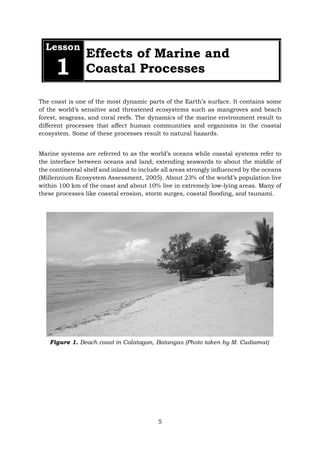
- 9. 5 Lesson 1 Effects of Marine and Coastal Processes The coast is one of the most dynamic parts of the EarthŌĆÖs surface. It contains some of the worldŌĆÖs sensitive and threatened ecosystems such as mangroves and beach forest, seagrass, and coral reefs. The dynamics of the marine environment result to different processes that affect human communities and organisms in the coastal ecosystem. Some of these processes result to natural hazards. Marine systems are referred to as the worldŌĆÖs oceans while coastal systems refer to the interface between oceans and land, extending seawards to about the middle of the continental shelf and inland to include all areas strongly influenced by the oceans (Millennium Ecosystem Assessment, 2005). About 23% of the worldŌĆÖs population live within 100 km of the coast and about 10% live in extremely low-lying areas. Many of these processes like coastal erosion, storm surges, coastal flooding, and tsunami. Figure 1. Beach coast in Calatagan, Batangas (Photo taken by M. Cudiamat)
- 10. 6 WhatŌĆÖs In Coastal processes are activities that regularly happen in the marine ecosystem as influenced by the weather, climate, and the adjacent landscape. Let us check your understanding about coastal and marine processes. Activity 1: Word Decoding Directions. Rearrange the jumbled letters and identify the term being referred to in each of the following items. Write your answer on the space provided. 1. These are caused by the gravitational pull between the moon and Earth. 2. They are formed by the wind and storm in the ocean. 3. This is caused by the melting of glaciers and iceberg. 4. It refers to the motion of the outermost shell of the Earth. 5. This is the rising of the seawater due to atmospheric conditions. E I T S D A W V E S E V L E L E S A E S I R S A C U R L T N T E V M O M E U R E G S R M T O S
- 11. 7 Activity 2: My Picture of Human and Coastal Environment Directions. On the box provided below, draw a coastline that will show the interaction of humans and the coastal environment using the coastal terms listed below. Then, describe your illustration in not less than 3-sentences. Notes to the Teacher The teacher may provide these definitions to the learners whose immediate environment is not located in the coast. Coastal forest is a type of forest in the beach or coastline dominated by mangroves. Estuary refers to an area where river or stream meets the ocean. Humans Estuary/river Beach Coastal forest/trees Waves
- 12. 8 WhatŌĆÖs New Revisiting Marine and Coastal Processes What have you noticed about the terms used in the previous activity? Actually, these are all marine and coastal processes. The scientific field dealing with these processes happening in our major oceans and seas is called oceanography. It is an interdisciplinary field of science that integrates the different fields such as physics, chemistry, biology, geology, meteorology, mathematics and even the social sciences to understand the link between humans and oceans. Coastal processes are activities or events happening in the marine environment. These are driven by the different environmental factors such as atmospheric pressure, temperature, movement of the Earth, moon, and other dynamic changes in the ocean. Now, let us talk about the different coastal processes in details. Coastal processes include waves, tides, sea level change, crustal movement, and storm surge. Waves are caused by the movement of the air masses in the coastal environment. Tides refer to the gravitational pull between the Earth and the moon. Sea level change is a result of the rise of ocean water which can be attributed to the melting of glaciers or iceberg in the polar regions. Storm surge refers to the rising of seawater due to changes in pressure and wind associated with a storm. Crustal movement is caused by the motion of the oceanic and continental crust of the Earth. Effects of Marine and Coastal Processes The different coastal processes described above may result to coastal hazards. Coastal hazards are physical phenomena that expose the marine environment to risk of property damage, loss of life and ecological degradation (Figure 2). Coastal Hazards Coastal Erosion Saltwater Intrusion Submersion Figure 2. Concept map of coastal hazards
- 13. 9 Coastal Erosion It is the loss or displacement of land along the coastline due to the action of waves, currents, tides, wind-driven water, or other impacts of storms. Coastal erosion is a type of coastal hazard which is brought about by the different coastal processes. Saltwater Intrusion It is a major concern commonly found in coastal aquifers around the world. An aquifer is an underground layer of permeable rock, gravel, sand or silt. Groundwater from an aquifer is usually extracted by a water well. Once an aquifer becomes contaminated it becomes unusable anywhere from 2 weeks to 10,000 years. Saltwater intrusion is the induced flow of seawater into freshwater aquifers primarily caused by groundwater development near the coast. Figure 3. Coastal Erosion Figure 4. Aquifer
- 14. 10 Submersion It refers to the movement of coastal sediments from the visible portion of a beach to the submerged nearshore region of the coast. Figure 5. Saltwater intrusion Figure 6. Submersion
- 15. 11 What is It The figure below shows the link between marine and coastal processes and coastal hazards. These processes could lead to hazards in the coastline that can be mitigated through different coastal management techniques which you will study in the next module. Coastal Hazards Coastal Erosion Saltwater Intrusion Submersion Figure 7. Concept map of the relationship between marine and coastal processes and coastal hazards Marine and coastal processes such as waves, tides, sea level change, storm surge and crustal movement have environmental effects that may result to
- 16. 12 WhatŌĆÖs More Activity 3. Picture Analysis Directions. Look at the pictures presented below. Describe how prone or vulnerable the places are to coastal hazards. Answers must be at least 2 sentences. 1. 2. Figure 8. Calatagan coastline (Photo taken during fieldwork of M. Cudiamat) Figure 9. Part of a river leading to mangrove forest in Mogpog, Marinduque (Photo taken during fieldwork of M. Cudiamat)
- 17. 13 3. Activity 4. Poster Making Directions. Prepare a poster with the theme: ŌĆ£Coastal Processes and their Impacts to SocietyŌĆØ. Scoring criteria are as follows: Relevance to the theme 4 points Creativity 3 points Originality 3 points TOTAL 10 points Post your draft here. Figure 20. Exposed beach front during low tide in Bali, Indonesia (Photo taken by M. Cudiamat)
- 18. 14 What I Have Learned Directions. Answer the given questions in a concise but substantial manner. 1. What happens when submersion, coastal erosion and saltwater intrusion occur? ___________________________________________________________________________ ___________________________________________________________________________ 2. Why is it important to study coastal and marine processes? ___________________________________________________________________________ ___________________________________________________________________________ What I Can Do Directions: As a Senior High School student, how can you help the local government to mitigate the harmful effects of coastal and marine processes such as coastal erosion, submersion, and saltwater intrusion assuming that your community is prone to these coastal hazards. __________________________________________________________________________________ __________________________________________________________________________________ __________________________________________________________________________________ __________________________________________________________________________________
- 19. 15 Assessment Directions. Read the following questions and choose the letter of the best answer. Write the chosen letter on a separate sheet of paper. 1. Which of the following is NOT a coastal process? A. landslides B. storm surge C. tides D. waves 2. Which of the following is caused by the gravitational pull of the moon and Earth? A. sea level rise B. storm surge C. tides D. tsunami 3. Which of the following is attributed to the rising of sea level in the polar region? A. continent B. crust C. glacier D. snow 4. What refers to the rising of seawater due to pressure and wind associated with a storm? A. crustal movement B. storm surge C. tides D. waves 5. Which of the following statements is NOT TRUE about coastal processes? A. Beach is prone to erosion. B. Erosion only occurs in the upland areas. C. Wind is a contributory factor to storm surge. D. Ocean waves cause water to move in the seashore. 6. Which of the following is NOT a coastal hazard? A. coastal erosion B. landslide C. saltwater intrusion D. submersion 7. What is described as an induced flow of seawater into freshwater aquifers primarily caused by groundwater development near the coast? A. coastal erosion B. saltwater intrusion C. storm surge D. submersion
- 20. 16 8. Which of the following is NOT an agent of coastal erosion? A. land pollution B. ocean waves C. storms D. tides 9. What do you call the movement of sediments from the visible portion of a beach to the nearshore region of the coast? A. coastal erosion B. saltwater intrusion C. storm surge D. submersion 10.Which of the following coastal processes may cause hazards in the marine environment? A. crustal movement B. tides C. waves D. all of the above 11.What do you call the scientific study of the chemical, biological and physical properties of ocean water? A. Biology B. Chemistry C. Oceanography D. Physics 12.Where can we usually find aquifers? A. underground B. in the ocean waves C. on the top of the mountain D. top surface of the rivers 13.What two ions compose mainly the seawater? A. hydrogen and oxygen B. hydrogen and potassium C. nitrogen and phosphorus D. sodium and chlorine 14.Which system is broader? A. coastal system B. marine system C. both A and B D. neither A nor B 15.As a student, what ways can you do to help adapt and mitigate coastal hazards? A. Educate yourself. B. Promote the programs of the community. C. Participate in local disaster preparedness program. D. All of the above
- 21. 17 Additional Activities Directions. Read the article below from the Philippine Star in relation to the effects of marine and coastal processes. Answer the following questions based on the article you have read. 1. What is the article all about? 2. How did the MGB define coastal erosion? 3. What is the recommendation of the MGB about the issue? A. Coastal Erosion MGB: Coastal erosion caused Zambales beach collapse by Rhodina Villanueva (The Philippine Star) - July 2, 2013 - 12:00am MANILA, Philippines - The Mines and Geosciences Bureau (MGB) yesterday said that the collapse of the coastline of a beach resort in Candelaria, Zambales does not constitute a sinkhole phenomenon but was a result of coastal erosion. MGB Director Leo Jasareno said they are recommending that the area be declared permanently as a no swimming and danger zone as well. Jasareno said with the use of ground penetrating radar (GPR) equipment, a team of geologists who investigated found no voids or cavities, or even a sinkhole in the affected area. What was identified were alternating layers of loose and fine to coarse sand 18.5 meters below the surface, he said. The equipment functions like an X-ray that can check land sinking up to 100 meters or 300 feet below. The beach slump is not due to sinkhole but is a result of coastal erosion caused by wave and tidal currents. Waves undercut the base of the shoreface, which happened during the interface of low tide and high tide, with the prevailing southwest monsoon, the MGB report said. Jasareno noted that the area is underlain by unconsolidated beach sand that is unstable and easily reworked by waves. The coastal sedimentation dynamics is indicated by the advance and retreat of the shoreline, and that the area is also prone to storm surge hazard, he said. He said coastal erosion is a natural phenomenon leading to the formation of a cliff 100 meters from the shoreline. The depth of the cliff or the steep slope from the shoreline is about 25 to 30 meters. The MGB recommended continuous monitoring of the area for large-scale erosion and storm surge, particularly when there is an incoming weather disturbance. A danger zone should be declared as the area is highly prone to coastal erosion, he added. The MGB estimated the danger zone to be 100 kilometers long and the width to be 20 to 30 meters.
- 22. 18 Answer the following questions based on the article you have read. 1. What is the article all about? 2. How will you relate coastal hazards to water crisis in the Philippines? B. Saltwater Intrusion Saltwater Intrusion Threatening Potable Water Supplies in Philippines 21 Jun 2010 - 20:58 by OOSKAnews Correspondent MANILA, PHILIPPINES Some 19 areas within the Philippines are facing contamination due to saltwater intrusion, as many continue to extract water from the nation's aquifers, according to the Philippine Sanitation Alliance (PSA) Elisea Gozun, former Environment Secretary and current president of PSA and member of Earth Day Network Philippines, presented the findings based on government data on June 17. "This is an irreversible process," Business Mirror quoted Gozun as saying. More than half, or some 58 percent, of groundwater that is to be used for potable supplies "is contaminated and needs treatment," she added. Also, saltwater intrusion is affecting one of the nation's last remaining potable water supply sources: rivers. Forty-nine percent of the river systems classified for drinking water do not meet pollution standards. The PSA expected Pasig-Laguna, Pampanga, Agno, Bicol, Cagayan, Western Visayas and Cebu to be adversely affected by 2025. The economic costs of the pollution are thought to exceed $ 1.7 billion USD each year, with health costs from improper sanitation making up the lion's share at $1.2 billion USD, followed by water costs like domestic use and fish production at $391 million USD. Gozun stressed that the loss of life was even more costly. She said 55 Filipinos die every day from diseases related to poor sanitation and more than 11,338 Filipinos die each year from diarrhea. "Improving sanitation is the key to achieving most of the Millennium Development Goals," Gozun said. The PSA made both large-scale and small-scale suggestions for elevating the profile of the problem, including investment in wastewater management, rainwater harvesting, water reuse, repairing leaky household systems and using a cup of water to brush one's teeth. Meanwhile, Senator Edgardo J. Angara urged increased investment in water management and wastewater treatment. "Climate change, urbanization and the need to feed a growing population have put a strain on our finite water resources, and there is an urgent need to address the dangers they pose to the health of our people and the sustainability of our environment. More often than not, water sanitation and sewerage systems in the country is overlooked and neglected. We need to pour more resources into it," the Philippine Information Agency quoted Angara as saying. "The acute seasonal problem of lack of access to potable water has large economic costs, as well as profound impact on the quality of life. Poor water quality affects our citizens' health, lost agricultural production, threatens food security, and a host of other damaging consequences," he added.
- 24. 20 References A. Books and Journals A. Mukhopadhyay, R. Dasgupta, S. Hazra, D. Mitra. 2012. Coastal Hazards and Vulnerability: A Review. International Journal of Geology, Earth and Environmental Sciences. 2(1). pp. 57-69. Millennium Ecosystem Assessment. 2005. Ecosystems and Human Well-Being: Synthesis. Washington, DC: Island Press. B. Electronic References https://www.philstar.com/nation/2013/07/02/960479/mgb-coastal-erosion- caused-zambales-beach-collapse#y7lBoIebBQxOyi5H.99 https://www.ooskanews.com/southern-eastern-asia/saltwater-intrusion- threatening-potable-water-supplies-philippines
- 25. For inquiries or feedback, please write or call: Department of Education - Bureau of Learning Resources (DepEd-BLR) Ground Floor, Bonifacio Bldg., DepEd Complex Meralco Avenue, Pasig City, Philippines 1600 Telefax: (632) 8634-1072; 8634-1054; 8631-4985 Email Address: blr.lrqad@deped.gov.ph * blr.lrpd@deped.gov.ph