


More Related Content
What's hot (20)
Similar to Geography Chapter 7 (20)


Recently uploaded (20)


Geography Chapter 7
- 1. Class 7 Geography Chapter 7 Human Environment
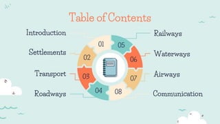
- 4. Introduction â—Ź Human beings are dependent on the environment. â—Ź To grow food, build homes and develop better means of transport and communication, human beings have modified the environment.
- 6. Settlements â—Ź Settlements are places where people build their homes. â—Ź The settlements earlier grew near river valleys as water was easily available and land was fertile. â—Ź Settlements can be permanent or temporary. â—Ź Settlements which are occupied for a short time are called temporary settlements. â—Ź In permanent settlements, people build homes to live in. â—Ź Settlements can be rural or urban.
- 7. Settlements â—Ź Rural settlements can be compact or scattered. â—Ź People in rural areas practice agriculture, fishing, forestry, crafts work and trading etc. â—Ź In the urban area, people are mostly engaged in services. â—Ź In regions of heavy rainfall, people have slanting roofs. â—Ź Thick mud-walled houses with thatched roofs are very common in areas of hot climate. â—Ź The towns are small and the cities are larger urban settlements.
- 8. Transport 03
- 9. Transport â—Ź Transport is the means by which people and goods move. â—Ź With the invention of the wheel, transport became easier. â—Ź Earlier donkeys, mules, bullocks and camels were used for transportation. â—Ź Earlier traders took the land route or sea route for transportation. â—Ź Now it takes only 6-8 hours to travel from India to Europe. â—Ź The four major means of transport are roadways, railways, waterways and airways.
- 10. Roadways 04
- 11. Roadways â—Ź It is the most commonly used means of transport, especially for short distances. â—Ź They can be metalled (pucca) or unmetalled (kutcha). â—Ź The plains have a dense network of roads. â—Ź Roads have also been built in terrains like deserts, forests and even high mountains. â—Ź Manali-Leh highway in the Himlayan Mountains is one of the highest roadways in the world. â—Ź Roads built underground are called subways/under paths.
- 12. Roadways â—Ź Flyovers are built over raised structures.
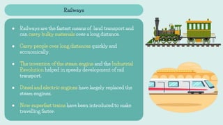
- 13. Railways 05
- 14. Railways â—Ź Railways are the fastest means of land transport and can carry bulky materials over a long distance. â—Ź Carry people over long distances quickly and economically. â—Ź The invention of the steam engine and the Industrial Revolution helped in speedy development of rail transport. â—Ź Diesel and electric engines have largely replaced the steam engines. â—Ź Now superfast trains have been introduced to make travelling faster.
- 15. Railways â—Ź Indian Railways network is the largest in Asia.
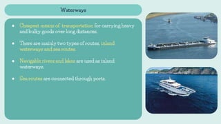
- 16. Waterways 06
- 17. Waterways â—Ź Cheapest means of transportation for carrying heavy and bulky goods over long distances. â—Ź There are mainly two types of routes, inland waterways and sea routes. â—Ź Navigable rivers and lakes are used as inland waterways. â—Ź Sea routes are connected through ports.
- 18. Airways 07
- 19. Airways â—Ź Fastest and most expensive mode of transport. â—Ź It is the only mode of transport to reach the most remote and distant areas especially where there are no roads and railways. â—Ź Some of the important airports in the world are Delhi, Mumbai, New York, London, Paris, Frankfurt and Cairo. â—Ź Helicopters are extremely useful in most inaccessible areas and in time of calamities for rescuing people and distributing food, water, clothes and medicines.
- 20. Communication 08
- 21. Communication â—Ź Process of conveying the message to others is known as communication. â—Ź Different modes of communication are used to provide information, to educate as well as to entertain. â—Ź Communication is of two types mainly, personal and mass communication.