This document discusses a study to understand bicyclist route preferences and behavior through stated preference surveys and revealed GPS data. It describes plans to conduct an in-street choice experiment survey in Copenhagen involving choice sets comparing routes defined by attributes like bike infrastructure type, number of other bicyclists and parked cars, green space, and travel time. The survey would collect stated preferences and recruit volunteers for GPS tracking to reveal actual route choices. The goal is to identify key attributes influencing route selection and inform simulation models.
The document discusses options for connecting the Brooklyn Bridge Park Greenway bike path through the Fulton Ferry Plaza area. It analyzes 3 alternatives: 1) Keeping the path in the park, 2) Improving DOT bike lanes on Old Fulton Street, or 3) An on-street separated path along the park curb. The recommended option combines alternatives 1 and 2, providing a choice for cyclists to use an in-park path or DOT lanes. Next steps include signage improvements and understanding future redevelopment plans.
Gertrud | Bikeability Workshop December 2010Morten Meyer
油
This document outlines the goals and workpackages of a research project aimed at understanding factors that influence bicycle usage in cities. The project involves 18 researchers from multiple universities and organizations. It aims to create knowledge to help cities enhance bikeability by investigating how social, urban, and infrastructure factors impact cycling behavior. The five workpackages include studying cyclist behavior and motivations, environmental determinants of bikeability, simulating cyclist behavior, evaluating infrastructure interventions, and providing guidance to policymakers. Challenges include integrating the diverse backgrounds, methods, and data across the multiple workpackages and disciplines to produce valid, useful results.
Wolfgang | Bikeability Workshop December 2010Morten Meyer
油
Various techniques can be used to incorporate spatial variables into choice experiments. Spatial representation, using maps or profiles, can provide valuable context and reduce preference variability compared to non-spatial methods. Both rigorous and artistic approaches were presented, with the rigorous using GIS and the artistic providing more freedom. Lessons indicated that while reality imposes constraints, more freedom may be needed to represent reality, and spatial context adds complexity not possible without spatial tools.
Microfundo is a platform that connects musicians seeking funding with individuals wanting to invest in and support artists. It works by allowing musicians to create profiles and set funding targets for projects like recording an album. Investors like college student Dani can browse artists, listen to their music, and invest small amounts to support projects in exchange for a share of future revenue. This helps musicians like Wanito from Haiti record music while providing returns to investors and supporting music and arts programs for youth.
Thomas & Ezra | Bikeability Workshop December 2010Morten Meyer
油
This document discusses the main questions and methodology for Work Package 1 (WP1) of a research project on cycling behavior. WP1 aims to understand what determines cycling and how motivations and lifestyles interact with urban form and design. It will use both quantitative analysis of travel survey data and qualitative interviews to explore the role of attitudes, opportunities, constraints, mobility styles, and lifestyle choices on cycling practices. The document outlines theoretical frameworks, potential subject areas for a tailored survey, and issues to explore qualitatively such as convenience and safety perceptions.
Dave | Bikeability Workshop December 2010Morten Meyer
油
1. The document discusses cycling research being conducted in England, including projects examining cycling trends, comparing England to Denmark, and understanding cycling through qualitative research methods.
2. The research is using household interviews, go-alongs, and ethnography to understand cycling via household decision-making in case study areas in Leeds, Leicester, Worcester, and Lancaster.
3. Early interpretations from the qualitative research are analyzing how emerging discourses around sustainable transportation differ across the case study areas and populations with different housing, car ownership, and demographic characteristics.
Victor | Bikability Workshop Decemver 2010Morten Meyer
油
This document outlines a study investigating different bike infrastructure cases through a web-based survey. The goal is to assess knowledge about the effects of different bike infrastructure typologies. Case studies were selected that were less than 5 years old, had distinct typologies, and local governments interested in sharing information. Data was collected through web surveys, bike counts, interviews, observations, and images. The document structures the analysis by city scale and infrastructure scale factors. It provides before and after images and descriptions of the street designs and traffic calming measures investigated. It analyzes respondents' residential locations, bike parking, signage, counts, and satisfaction. Final considerations discuss the importance of connectivity and safety in bike infrastructure design.
Social media als ingang voor cybercriminelen en wat je daar als digital marke...Dennis Koorn
油
Presentatie die ik samen met mijn collega Theo Reichgelt heb gegeven bij Digital Marketing & Social Strategy in 1 day. Over waarom marketeers de verantwoordelijkheid moeten nemen om social media te beveiligen. Vaak de slechtst beveiligde achterdeur binnen organisaties. En dat terwijl er maar 15 minuten nodig is om een aanval via social media voor te bereiden.
This document outlines the participatory budgeting process in Bratislava-Nov辿 Mesto (BANM). It describes the goals of participatory budgeting as achieving the best decisions based on democracy. It explains the three categories of projects that residents can propose and vote on: 1) small, innovative civic projects, 2) larger investment projects, and 3) priorities to guide future development. The document discusses the benefits of participatory budgeting for residents and the government, as well as some positive and negative experiences in implementing this process in BANM.
Hans & Bernhard | Bikeability Workshop December 2010Morten Meyer
油
The document discusses simulating bicyclist behavior using agent-based modeling. It proposes using GPS data from revealed preference studies to model route and junction choices. Agent-based simulation could model bicyclists' local perceptions and behavior to gain insights not available from traffic or pedestrian models alone. Data needs include trip origins/destinations and infrastructure details, while behavioral rules could cover route choices and moods. The simulation aims to study impacts of infrastructure changes and cycling trends.
Hoe implementeer je een social media ambassadeursprogrammaDennis Koorn
油
Op 16-11-2016 organiseerden wij een inspiratiesessie over social media ambassadeurs. Deze presentatie licht toe hoe je dit met behulp van een 90 dagen plan binnen je organisatie implementeert.
Seocamp2016 : javascript et indexation, o湛 en est-on ?Madeline Pinthon
油
Google annonce comprendre le JavaScript mais qu'en est-il exactement ?
Plus d'information : http://www.iprospect.com/fr/fr/le-blog/indexation-javascript/
Application of gps tracking in bicycle researchcdc2013workshop
油
Second keynote speaker presentation
By Hans Skov-Petersen
BIKEABILITY & University of Copenhagen, Denmark
Topic: Application of GPS tracking in bicycle research
Cycling Scotland course on planning and designing for cyclists. The course was held in Fort William and looked at the local area and identified improvements to the local cycle routes.
Complete Streets Design and Separation of UsersCarly Queen
油
This document summarizes a presentation on complete streets design and separation of users for safety and sustainability. It discusses:
- The need to improve safety for more vulnerable users like pedestrians and cyclists given the current car-oriented transportation system in the US.
- How complete streets that accommodate all users can help create more sustainable transportation options and development patterns.
- Guidelines for accommodating different types of users on streets, emphasizing lower speeds, separation or sharing based on context, and prioritizing pedestrians.
The study aims to quantify how people make trade-offs to avoid junctions by taking additional time along routes with and without cycle facilities in the UK context. A video based stated preference survey and analysis is undertaken to investigate how people feel approaching junctions, determine the relative importance of the features of junctions, determine how cycle facilities compensate the exposure of right turn risks at junctions at the cost of additional time and identify the person type factors that also influence choice. Primary data is used for the study. The survey work for the primary data constituted a major part of the study.
Northern Transport Summit: Danny Crump, Broadway Malyan & Nicola Kane, TfGMPlace North West
油
This document presents information on creating more equitable streets that balance the movement of people and goods. It discusses pilot projects in Greater Manchester that aim to reallocate street space from cars to walking, cycling, and public transit. The projects use a co-design process involving local stakeholders to understand issues like high car dependency, congested streets, and unsafe environments for pedestrians. The goal is to rebalance streets to encourage modal shift, improve public health, and enhance local communities and places. Next steps include detailed street design, developing design principles and strategies, and taking lessons from the pilot projects.
World usa pres_2017_en_systematic safety - action plan for boston_pfurthpatxigalarraga
油
This document summarizes key principles from Europe's Vision Zero traffic safety program and proposes an action plan for Boston to implement similar systematic safety measures. The summary is:
[1] It outlines principles like safe mobility as a civil right and road owners being responsible for safety. [2] It proposes an action plan for Boston including speed control through traffic calming, road diets, safer bike infrastructure, crossings, and long-term policies to reduce car dependence. [3] The plan provides examples of treatments and policies to institutionalize systematic safety approaches in Boston.
This document discusses making local streets safer for cycling to encourage more children and families to ride. It notes declines in cycling and increases in obesity and car dependence. Safer streets could promote active transport, reduce congestion, and build community. However, high speeds and lack of safe routes and perceptions of danger pose challenges. Solutions discussed include lower speed limits, on-street parking for protection, separated facilities, equitable speeds of 30km/h or less, education, priority for cyclists at intersections, safe routes to school, innovative designs, and nurturing a culture of respect between all road users. Key is creating an environment where cycling is intuitive and perceived as safe.
Getting Children Riding Again: Making Local Streets Safer for CyclingPhil Gray
油
This document discusses making local streets safer for cycling by children. It notes declines in children riding and increases in obesity and car dependence. Safer streets could encourage active children and reduce congestion. However, speeding cars and lack of safe routes and perceptions of danger pose challenges. Infrastructure like traffic calming, bike lanes, roundabouts, and contraflow lanes that reduce speeds and prioritize cyclists are discussed. Local examples showing how streets in Australia have implemented such features are provided. The key points are creating equitable speeds of 30km/h or less, direct low volume routes, innovative bike priority designs, and nurturing a culture of respect between all street users.
This document outlines a study and proposed design recommendations to improve bike safety and accessibility on Shattuck Avenue in downtown Berkeley. It summarizes a literature review on bike facilities and route choice, the results of a cyclist survey, and proposed street design plans. The survey found that Shattuck Avenue cyclists prefer faster routes and experienced dangerous situations at intersections and bus stops. The design recommendations propose bike paths or lanes where possible, colored bike treatments at intersections, and cycle tracks behind bus stops to create a complete street that better accommodates cyclists.
Local streets are proving grounds for most cycling trips. The document discusses designs for local streets to make cycling safer and more accessible for different types of cyclists, including children, elderly people, and those with varying skill and comfort levels. Recommendations include lowering speed limits to 30 km/h or below, adding bicycle infrastructure like separated paths, and ensuring safe routes to schools. Intuitive designs like bicycle boulevards that prioritize cyclists can encourage cycling by creating a culture of respect between all street users.
On/Off Road Cycle Infrastructure Review - Urban
Venue: Glasgow - Cycling Scotland Office
Site Visit: Glasgow Connect 2 Cycle Infrastructure
Date: Wednesday 31st August 2011
Start Time 9.30am
Brief Description: Review of Connect 2 infrastructure installed within Glasgow. This will be completed by a series of workshops on designing for cyclists looking in depth at current design manuals and providing a more technical review of current standards. Site visits will be used to review the infrastructure completing the day with a feedback session on the installed infrastructure.
Designing & Planning for Cycling, Phil Jones & Adrian LordDesign South East
油
Presentation on Design and Planning for cycling from the Designing and Planning for Cycling workshop at MADE on 19th May 2015. Presentation by Phil Jones and Adrian Lord, Phil Jones Associates.
New Tools for Estimating Walking and Bicycling Demand
Track: Sustain
Format: 90 minute panel
Abstract: Walking and bicycling demand estimates can make a stronger case for investing in new facilities and are necessary inputs to important planning tasks. This session presents state-of-the-art tools to predict walking and bicycling demand at varying geographic scales. Tools include: 1) a framework to incorporate walking into regional travel demand models; 2) a method to estimate bicycle and pedestrian traffic based on count data; 3) new mode choice models; and 4) a web-based repository of non-motorized demand analysis tools.
Presenter(s)
Presenter: Patrick Singleton Portland State University
Co-Presenter: J. Richard (Rich) Kuzmyak Renaissance Planning Group
Co-Presenter: Greg Lindsey University of Minnesota, Humphrey School
Co-Presenter: Jeremy Raw Federal Highway Administration
The document summarizes a master plan presentation for improvements to the Cape La Croix trail system. It includes an overview of the trail and master planning process, summaries of public input on desired amenities and priorities for the trail, an analysis of existing conditions that revealed issues with lighting, underpasses, comfort stations, seating and signage, and an emerging master plan that shows proposed improvements to address deficiencies and includes concepts for branding, wayfinding, and standardized furnishings. Next steps include finalizing the plan, developing cost estimates, prioritizing projects, and implementing improvements.
Columbia, Missouri is a small city with a population of 100,000 that is not densely populated and has hills, weather extremes, and urban sprawl barriers. The city aims to create an integrated bike and pedestrian system by adding bike lanes wherever possible and innovating ideas from other cities. In 2010, the system included 30 miles of shared use paths, 50 miles of bike lanes on streets, and 30 miles of shared lane markings. The city has experimented with several innovations for bike and pedestrian infrastructure including on-street wayfinding, loop detector markings, buffered bike lanes, and advisory bike lanes in the center of low-traffic streets.
Bicyclist and Pedestrian Safety and Mobility in EuropeSharon Roerty
油
This document summarizes the findings of an international scan tour on pedestrian and bicyclist safety and mobility. The tour visited several cities in Europe and found that they have achieved high rates of walking and bicycling through deliberate policies across engineering, education, enforcement, encouragement, and evaluation. The scan team recommends that US agencies establish policies prioritizing walking and bicycling, develop performance measures to track progress, and implement various engineering and programmatic measures observed abroad to create safer, more convenient conditions for active transportation.
Dr Piotr Kuropatwiski: Lessons learnt from the process of development of su...Viktor Zagreba
油
This document summarizes a presentation on lessons learned from developing sustainable transport infrastructure in Gdansk, Poland. It discusses how current urban transport policy favors motor vehicles over other modes and outlines alternative approaches. These include prioritizing improvements to walking conditions, mainstreaming cycling, and using education to promote active mobility and multi-modal trip chains. The conclusion is that simply focusing on public transit is not enough; soft measures like information campaigns are also needed to change mindsets and enable truly sustainable transport solutions.
November 2011 Street Talk by Richard Bourn and Richard Hebditch, Campaign for Better Transport. Brought to you by Movement for Liveable London -
movementforliveablelondon.com
1. WP3: Simulation of bicyclist behaviour Bicyclists route choice: Presentation of a choice experiment design and application of GPS tracks to a revealed preference study What do bi-cyclists prefer, and what do they do? Jette Bredahl Jacobsen - [email_address] Hans Skov-Petersen [email_address] Suzanne Elizabeth Vedel - [email_address] Bernhard Snizek - [email_address] Skov & Landskab, LIFE/KU
2. Overview Assessment of route choice Stated Preference (SP) vs Revealed Preference (RP) Choice Experiments (CE). Why? The survey (questionnaire) in general In-street application of the survey Selection of attributes Focus group interviews Literature Special Danish topics Methods Experiment design Selection of means of representation Anticipated results and their use
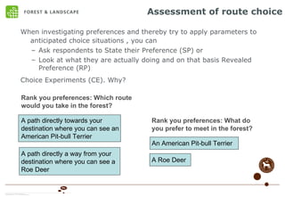
3. Assessment of route choice When investigating preferences and thereby try to apply parameters to anticipated choice situations , you can Ask respondents to State their Preference (SP) or Look at what they are actually doing and on that basis Revealed Preference (RP) Choice Experiments (CE). Why? Rank you preferences: What do you prefer to meet in the forest? An American Pit-bull Terrier A Roe Deer Rank you preferences: Which route would you take in the forest? A path directly towards your destination where you can see an American Pit-bull Terrier A path directly a way from your destination where you can see a Roe Deer
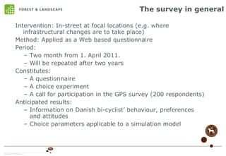
4. The survey in general Intervention: In-street at focal locations (e.g. where infrastructural changes are to take place) Method: Applied as a Web based questionnaire Period: Two month from 1. April 2011. Will be repeated after two years Constitutes: A questionnaire A choice experiment A call for participation in the GPS survey (200 respondents) Anticipated results: Information on Danish bi-cyclist behaviour, preferences and attitudes Choice parameters applicable to a simulation model
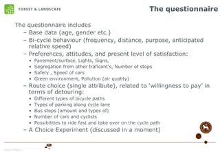
5. The questionnaire The questionnaire includes Base data (age, gender etc.) Bi-cycle behaviour (frequency, distance, purpose, anticipated relative speed) Preferences, attitudes, and present level of satisfaction: Pavement/surface, Lights, Signs, Segregation from other traficant's, Number of stops Safety , Speed of cars Green environment, Pollution (air quality) Route choice (single attribute), related to willingness to pay in terms of detouring: Different types of bicycle paths Types of parking along cycle lane Bus stops (amount and types of) Number of cars and cyclists Possibilities to ride fast and take over on the cycle path A Choice Experiment (discussed in a moment)
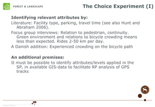
6. The Choice Experiment (I) Identifying relevant attributes by: Literature: Facility type, parking, travel time (see also Hunt and Abraham 2006). Focus group interviews: Relation to pedestrian, continuity. Green environment and relations to bicycle crowding means less than expected. Rides 2-50 km per day. A Danish addition: Experienced crowding on the bicycle path An additional premises: It must be possible to identify attributes/levels applied in the SP, in available GIS-data to facilitate RP analysis of GPS tracks
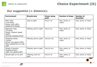
7. Choice Experiment (II) Our suggestion (+ distance): Few, some, or many Few, some, or many Yes or no (Missing, lane or) path Bicycle path on its own Few, some, or many Few, some, or many Yes (or no) Missing, lane or path Street in housing neighbourhood, Light, low speed traffic Few, some, or many Few, some, or many Yes (or no) Missing, lane or path Shopping street, 2 lanes, Dense, low speed traffic, Manu pedestrians on side walk Few, some, or many Few, some, or many Yes or no Missing, lane or path Approach road, 2-3 lanes, Dense, medium speed traffic, Housing neighbourhood Few, some, or many Few, some, or many Yes or no Lane or path Main road, 4 car lanes, Dense, fast traffic, scattered buildings Number of bicyclists Number of stops Green along path Bicycle lane Environment
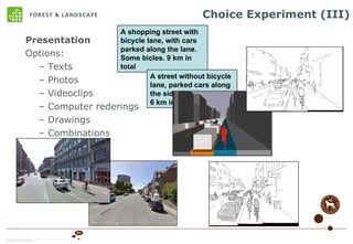
8. Choice Experiment (III) Presentation Options: Texts Photos Videoclips Computer rederings Drawings Combinations A shopping street with bicycle lane, with cars parked along the lane. Some bicles. 9 km in total A street without bicycle lane, parked cars along the side. Few bicycles. 6 km in total.
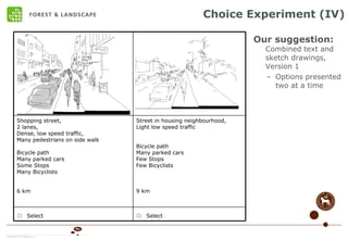
9. Choice Experiment (IV) Our suggestion: Combined text and sketch drawings, Version 1 Options presented two at a time o Select o Select Street in housing neighbourhood, Light low speed traffic Bicycle path Many parked cars Few Stops Few Bicyclists 9 km Shopping street, 2 lanes, Dense, low speed traffic, Many pedestrians on side walk Bicycle path Many parked cars Some Stops Many Bicyclists 6 km
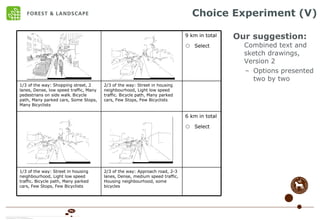
10. Choice Experiment (V) Our suggestion: Combined text and sketch drawings, Version 2 Options presented two by two 6 km in total o Select 9 km in total o Select 2/3 of the way: Street in housing neighbourhood, Light low speed traffic. Bicycle path, Many parked cars, Few Stops, Few Bicyclists 1/3 of the way: Shopping street, 2 lanes, Dense, low speed traffic, Many pedestrians on side walk . Bicycle path, Many parked cars, Some Stops, Many Bicyclists 2/3 of the way: Approach road, 2-3 lanes, Dense, medium speed traffic, Housing neighbourhood, some bicycles 1/3 of the way: Street in housing neighbourhood, Light low speed traffic. Bicycle path, Many parked cars, Few Stops, Few Bicyclists
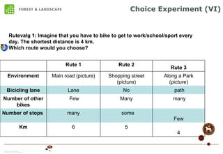
11. Choice Experiment (VI) Rutevalg 1: Imagine that you have to bike to get to work/school/sport every day. The shortest distance is 4 km. Which route would you choose? Few some many Number of stops 4 5 6 Km many Many Few Number of other bikes path No Lane Bicicling lane Along a Park (picture) Shopping street (picture) Main road (picture) Environment Rute 3 Rute 2 Rute 1
12. Yet to be considered: Combinations not possible for all environments Efficiency loss Experience with this? Excluding parked cars Essential? Even more efficiency loss Distance Total distance Extra distance as opposed to shortest route Whether to include a status quo or not Whether a route consists of one or several (two) sections
13. Thats it... Thanks... Jette Bredahl Jacobsen - [email_address] Hans Skov-Petersen [email_address] Suzanne Elizabeth Vedel - [email_address] Bernhard Snizek - [email_address] Skov & Landskab, LIFE/KU