La modellizzazione delle Personas e la creazione degli scenari d'uso sono tra i fondamenti del User centered design. In questa presentazione riportiamo alcun i esempi di Personas e alcune note su come impostare un test di usabilit con risorse limitate.
Pillola di presentazione sulla sintesi dei dati per il design, al termine di una sessione di ricerca.
La presentazione 竪 stata fatta all'interno del contesto della Co-Design Jam - Social Design for Urban Change (http://www.codesignjam.it/wudrome2015-social-design-for-urban-change/) organizzata da gruppo Co-Design Jam di Roma e da Nois3 (http://www.nois3.it/).
The document summarizes Kevin Lynch's book "Image of the City". Lynch studied how people perceive and understand cities based on mental maps. He identified 5 key elements that shape a person's mental map of a city: paths, edges, districts, nodes, and landmarks. Lynch also coined the terms "imageability" and "wayfinding". The book was influential in urban planning and psychology. It provided a framework to evaluate a city's form and image from a resident's perspective.
1. A schema describes how people organize information into categories and relationships to form mental images of urban environments.
2. Perception involves gathering, organizing, and interpreting sensory information through five steps like paying attention and assigning meaning.
3. Kevin Lynch studied how people navigate cities based on five key elements - paths, edges, districts, nodes, and landmarks - that give cities structure and identity in people's mental images.
4. Clear paths, edges, districts, nodes, and landmarks that connect to each other help form a legible urban image, while discontinuity and lack of identity can create an unclear image.
The document discusses elements of urban design that shape cities, including buildings, public spaces, streets, landscape, and their interrelationships. It also summarizes Kevin Lynch's book "The Image of the City", which examines how residents mentally map their city based on paths, edges, districts, nodes, and landmarks. Finally, it provides examples of these elements in Mysore, India, highlighting landmarks like the Ambavilas Palace, focal points like Chamaraja Circle, and the city's planned layout with vistas, public squares, and response of buildings to the street network.
Kevyn introduced a concept of planning that was the base for understanding and visualising The Planning Aspects; important for the budding planners.
The presentation initiates the same understanding and invokes a means for better understanding of 'Planning'.
The document summarizes Kevin Lynch's book "The Image of the City" which explores how people mentally perceive and navigate urban environments. It discusses Lynch's concepts of imageability, legibility, and the five elements that comprise a city's mental image for people - paths, edges, districts, nodes, and landmarks. It provides examples of Lynch's analysis of the mental images of Boston, Jersey City, and Los Angeles.
Urban design can significantly impact the economic, environmental, social, and cultural outcomes of a place. It influences factors like local business success, housing costs, transportation access, and how people interact. Key elements of urban design include buildings, public spaces, streets, transportation systems, and landscape features. Buildings define the streetscape while public spaces are where people come together. Streets connect places and their design impacts walkability. Transportation networks enable movement throughout the city. Landscape provides green spaces that enhance character and beauty.
Urban design is the process of shaping the physical setting of cities and villages. It deals with groups of buildings and the spaces between them, including streets, paths, gardens and squares. Urban design considers aesthetics and how the physical environment will be used. It requires input from multiple fields like engineering, ecology, history and transport planning. The best urban design involves interdisciplinary teams to create places that are good to live in, attractive to visit, establish community identity, reduce crime, and be socially and economically successful.
The document summarizes the existing conditions of the road network, land use patterns, built environment, and public spaces in Hackney central, London. It finds that the area has busy streets with traffic congestions and unclear pedestrian links, making it difficult to get around. It also has strong local landmarks like churches that provide clarity. However, the overhead railway line obstructs views and isolates some spaces. The pedestrian links and public spaces lack signage and have unsafe crossings, while green spaces are underdeveloped and underutilized.
1) The document discusses an urban community commercial neighborhood project in Olaia Street precinct in Riyadh, Saudi Arabia.
2) Riyadh is one of the fastest growing cities in the world with a population of 4.9 million people within an area of 2435 square kilometers.
3) The specific area being analyzed is located in the Olaia neighborhood in the center of Riyadh, which has a commercial strip that is the heart of business and interface for city visitors.
This document discusses the key elements of urban design: buildings, public spaces, streets, transport, and landscape. It provides examples for each element. Buildings shape urban spaces and give a sense of place. Public spaces are living rooms of the city where people gather. Streets connect spaces and are defined by their dimensions, scale, and surrounding buildings. Transport networks enable movement throughout cities. Landscape includes green spaces like parks and trees that provide contrast. Together these elements are woven into the overall urban design structure.
strumento di aggregazione di
Istituzioni, persone, enti, che
abbiano come obiettivo uno
sviluppo etico - sostenibile.
Inoltre, si impegna ad attivare una
rete di competenze, energie, professionalit e risorse di imprese,
enti ed associazioni che agiscano da moltiplicatori dello sviluppo di un
efficace sistema tecnologico, commerciale, sociale e culturale.
UnaReteDidatticaMultifunzionaleeSostenibileperAgripolis-ReDiMeS-ppt
Universit degli Studi di Padova Dip. TESAF - candidatura per il premio PA sostenibile e resiliente, promosso da Forum PA, in collaborazione con ASviS.
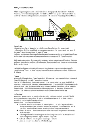
1. NABA
goes
to
CONTAINER
NABA
propone
agli
studenti
dei
corsi
di
Urban
Design
(proff.
Boccalini,
De
Michelis,
Pincovici)
unoccasione
di
progetto
per
CONTAINER,
uno
spazio
atto
a
diventare
un
centro
di
relazione
intergenerazionale,
sociale
e
di
servizi
al
Parco
Segantini
a
Milano.
Il
contesto
L'Associazione
Parco
Segantini
ha
collaborato
alla
redazione
del
progetto
di
realizzazione
del
Parco,
nel
farlo
ha
immaginato
unarea
che
rappresenti
una
sorta
di
ingresso,
accoglienza
reale
e
virtuale
allarea.
Un
luogo
non
lontano
da
piazza
Belfanti,
dove
si
potranno
svolgere
attivit
diversificate,
aggiornarsi
in
tempo
reale
sulle
evoluzioni
e
programmazioni
di
Parco
Segantini.
Sar
realizzato
tramite
il
recupero
di
container,
reinterpretati,
riqualificati
per
formare
un
luogo
accogliente,
confortevole,
che
possa
diventare
unicona
(anche
se
temporanea)
della
vita
del
Parco.
L'edificio
sar
realizzato
e
gestito
con
una
partnership
fra
associazioni
non
profit,
coordinate
da
"Opera
in
fiore",
su
aree
pubbliche
concesse
in
convenzione
dal
Comune
di
Milano.
I
tempi
Volont
dell'Associazione
Parco
Segantini
竪
di
inaugurare
questo
spazio
in
occasione
di
Expo
2015.
Quindi
entro
il
1属
maggio
prossimo.
Il
corso
di
Urban
Design
(iniziato
in
ottobre
e
che
si
concluder
in
febbraio
2015)
si
impegna
a
presentare
le
proposte
progettuali
entro
il
14
gennaio
2015
dopo
una
serie
di
incontri
con
le
varie
figure
coinvolte
atti
a
dare
un
grado
di
fattibilit
reale
ai
progetti.
Associazione
Parco
Segantini
organizzer
una
giuria
per
la
selezione
del
progetto
vincitore
che
proseguir
tempestivamente
nella
fase
esecutiva/operativa.
Le
funzioni
Container
vuole
essere
un
punto
di
incontro
per
studenti,
anziani,
genitori/bimbi,
associazioni
e
di
presentazione
di
spettacoli,
di
incontri
culturali
in
genere
e
altre
attivit
da
ipotizzare
in
fase
di
progetto.
Associazione
Parco
Segantini
chiede:
Un
punto
ristoro
con
presenza
di
servizi
igienici,
che
offra
la
possibilit
di
mangiare
alimenti
precucinati
-足
collegato
al
progetto
"Giardini
edibili"
per
la
cottura
e
somministrazione
dei
prodotti
coltivati
negli
orti
del
Parco.
Centro
di
servizi
-足
manutenzioni
biciclette,
corsi
di
cucito,
gestione
del
verde
primato,
altro.
Attivit
per
bambini
in
orario
pomeridiano,
organizzazione
di
attivit
ludico
ricreative
principalmente
legate
al
verde
e
agli
orti.
Fab
Lab
del
Parco
per
integrare
tecnologia
e
natura
Altro
da
pensare
con
il
corso
di
Urban
Design
2. Container
obiettivi
di
progetto
Associazione
Parco
Segantini
ipotizza
di
utilizzare
dei
container
non
da
trasporto,
ma
del
tipo
"abitativi"
da
cantiere,
integrabili
e
modulabili,
di
dimensioni
standard
240x600
cm
(15
mq
l'uno),
ed
hanno
la
soluzione
con
servizi
igienici
annessi.
La
fase
reperimento
container
non
竪
ancora
ultimata
quindi
questo
dato
potrebbe
cambiare
in
tipologia,
numero
e
dimensione.
Si
vuole
creare
un
sistema
che
colleghi
i
moduli
per
creare
spazi
adeguati
alle
esigenze
sopra
elencate
e
altre
ancora
da
definire.
I
moduli
sono
carenti
da
un
punto
di
vista
prestazionale
(soprattutto
legato
alla
climatizzazione)
e
estetico,
obiettivo
di
questa
collaborazione
(Parco
Segantini-足NABA)
竪
dare
un
identit
a
questo
nuovo
luogo
in
quanto
porta
del
Parco,
riferimento
spaziale
e
organizzativo
della
sua
attivit.
Gli
alunni
si
confronteranno
quindi
con
differenti
dimensioni
del
progetto
che
passano
dalla
scelta
della
location
esatta
alla
geometria
di
aggregazione,
dal
vestito
estetico
al
rivestimento
funzionale,
dalla
composizione
degli
spazi
interni
alla
loro
definizione
materica,
dalle
funzioni
reali
a
quelle
virtuali,
Budget
Associazione
Parco
Segantini
sta
definendo
un
budget
contenuto
con
la
volont
di
far
diventare
il
progetto
un
modello
da
replicare.
Si
ipotizza
che
ogni
unit
abitativa
usata
possa
costare
500
(per
un
totale
di
2.000);
il
costo
di
ristrutturazione
potr
raggiungere
in
prima
ipotesi
1.000
a
modulo
(totale
4.000
);
le
opere
di
integrazione
con
lesterno
altri
2.000,
per
un
totale
complessivo
di
circa
8.000.
Le
proposte
progettuali
non
potranno
esimersi
da
tenere
in
considerazione
questa
indicazione
ipotizzando
un
ordine
di
spesa.
Modalit
di
presentazione
I
progetti
verranno
presentati
in:
Formato
digitale
pdf:
concept
di
progetto
tramite
relazione
e
immagini
di
ispirazione,
inquadramento
del
progetto
nel
Parco
motivandone
la
scelta,
immagini
rappresentative
del
progetto
compreso
foto-足inserimento,
disegni
tecnici,
definizione
di
materiali
e
finiture,
preventivo
di
massima.
Formato
cartaceo
A4:
le
stesse
informazioni
del
pdf
ma
pi湛
dettagliate.
Foglio
A3verticale:
stampato
fronte
retro,
su
un
fronte
nome
e
immagine
rappresentativa
(fotomontaggio?),
sullaltro
inserimento
nel
sistema
parco
e
sintesi
delle
funzioni.
Video:
presentazione
del
progetto
tramite
un
breve
video
sullidea.
Criteri
di
valutazione
Fondamentali
per
la
scelta
saranno
gli
aspetti
Economici,
di
Fattibilit,
di
Funzione
aggiunta
oltre
alle
richieste,
oltre
alla
Creativit
e
alle
Competenze
Tecniche
-足
queste
ultime
possono
essere
colmate
da
altre
partnership
gi
in
essere
ma
non
sarebbe
male
che
gli
alunni
seguissero
il
progetto
sino
alla
sua
esecuzione).
Premio
Il
progetto
vincitore
sar
premiato
con
500
euro
e
il
gruppo
sar
coinvolto
nella
fase
esecutiva
sino
al
montaggio.
Associazione
Parco
Segantini
far
una
pubblicazione
di
tutti
i
lavori
presentati
e
organizzer
unesposizione
nel
Container,
o
in
altro
luogo
da
definire
(anche
in
NABA)
nei
giorni
della
sua
inaugurazione.
Per
tale
motivo
竪
fondamentale
che
gli
alunni
presentino
il
materiale
seguendo
le
indicazioni
date.
(lesposizione
dei
lavori
verr
definito
nel
dettaglio
a
seguire,
luoghi
e
date)