


More Related Content
What's hot (20)
Similar to 蚕耻补苍迟耻尘骋滨厂を使った笔辞蝉迟驳谤别厂蚕尝/笔辞蝉迟骋滨厂利用方法绍介 (20)


More from Yoichi Kayama (20)


Recently uploaded (15)


蚕耻补苍迟耻尘骋滨厂を使った笔辞蝉迟驳谤别厂蚕尝/笔辞蝉迟骋滨厂利用方法绍介
- 1. 蚕耻补苍迟耻尘骋滨厂を使った PostgreSQL/PostGIS利用方法紹介 OSGeo財団 日本支部 嘉山陽一 PostgreSQL Conference 2011
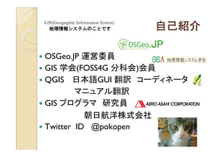
- 2. 自己紹介 GIS(Geographic Information System) 地理情報システムのことです OSGeo.JP 運営委員 GIS 学会(FOSS4G 分科会)会員 QGIS 日本語GUI 翻訳 コーディネータ マニュアル翻訳 GIS プログラマ 研究員 朝日航洋株式会社 Twitter ID @pokopen
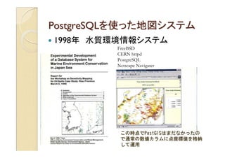
- 3. PostgreSQLを使った地図システム 1998年 水質環境情報システム FreeBSD CERN httpd PostgreSQL Netscape Navigater この時点でPostGISはまだなかったの で通常の数値カラムに点座標値を格納 して運用
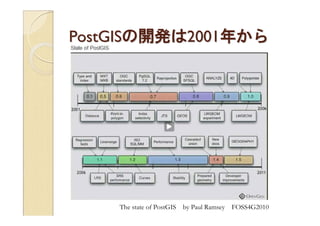
- 4. 笔辞蝉迟骋滨厂の开発は2001年から The state of PostGIS by Paul Ramsey FOSS4G2010
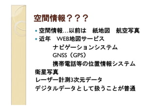
- 5. 空間情報??? 空間情報…以前は 紙地図 航空写真 近年 WEB地図サービス ナビゲーションシステム GNSS(GPS) 携帯電話等の位置情報システム 衛星写真 レーザー計測3次元データ デジタルデータとして扱うことが普通
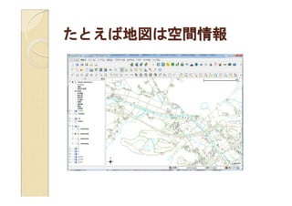
- 6. たとえば地図は空间情报
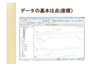
- 7. データの基本は点(座标)
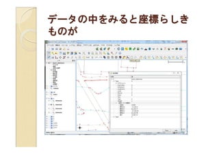
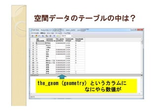
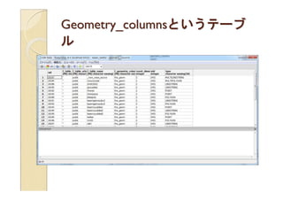
- 9. 空間データのテーブルの中は? the_geom (geometry) というカラムに なにやら数値が
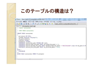
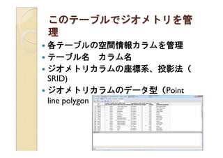
- 10. このテーブルの构造は?
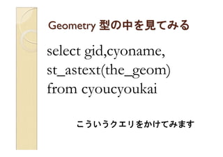
- 11. Geometry 型の中を見てみる select gid,cyoname, st_astext(the_geom) from cyoucyoukai こういうクエリをかけてみます
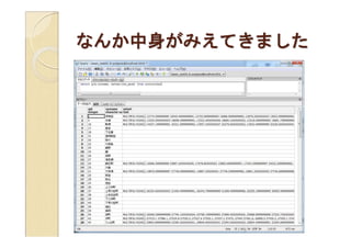
- 12. なんか中身がみえてきました
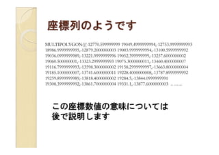
- 13. 座標列のようです MULTIPOLYGON(((-12770.599999999 19049.4999999994,-12753.9999999993 18986.9999999995,-12879.2000000003 19003.9999999994,-13100.5999999992 19036.0999999989,-13221.9999999996 19052.399999999,-13257.6000000002 19060.500000001,-13323.2999999993 19075.3000000011,-13460.4000000007 19116.7999999993,-13598.3000000002 19158.2999999997,-13663.8000000004 19185.1000000007,-13741.6000000011 19228.4000000008,-13787.8999999992 19259.8999999989,-13818.4000000002 19284.5,-13844.0999999991 19308.3999999992,-13861.7000000004 19331.1,-13877.6000000003 …….. この座標数値の意味については 後で説明します
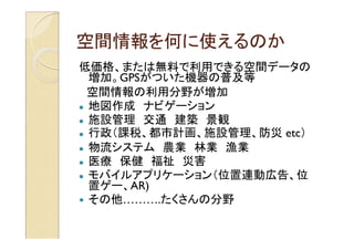
- 14. 空間情報を何に使えるのか 低価格、または無料で利用できる空間データの 増加。GPSがついた機器の普及等 空間情報の利用分野が増加 地図作成 ナビゲーション 施設管理 交通 建築 景観 行政(課税、都市計画、施設管理、防災 etc) 物流システム 農業 林業 漁業 医療 保健 福祉 災害 モバイルアプリケーション(位置連動広告、位 置ゲー、AR) その他……….たくさんの分野
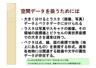
- 15. 空間データを扱うためには 大きく分けるとラスタ(画像、写真) データとベクタデータに分けられる ラスタは写真やスキャナの画像。その 領域の座標値とピクセルの実世界座標 での大きさを通常は持つ。 ベクタは点、線、面の座標で地物(地 上にあるもの)を表現する形式。通常 各地物には関連する数値や文字の属性 データが存在する。 PostGISは安定版ではベクタデータのみあつかい可能 (ラスタが扱えるブランチはある 準备中の痴2.0でラスタ标準実装予定)
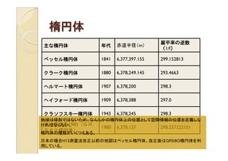
- 17. 楕円体 扁平率の逆数 主な楕円体 年代 赤道半径(m) (1/f) ベッセル楕円体 1841 6,377,397.155 299.152813 クラーク楕円体 1880 6,378,249.145 293.4663 ヘルマート楕円体 1907 6,378,200 298.3 ヘイフォード楕円体 1909 6,378,388 297.0 クラソフスキー楕円体 1943 6,378,245 298.3 地球は球形ではないため、なんらかの楕円体上の位置として空間情報の位置を定義しな 測地基準系1980(GR ければならない。 1980 6,378,137 298.257222101 S80楕円体) 楕円体の種類がいくつもある。 日本の場合H13測量法改正以前の地図はベッセル楕円体。改正後はGRS80楕円体を利 用している。
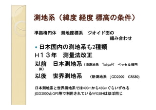
- 18. 測地系(緯度 経度 標高の条件) 準拠楕円体 測地座標系 ジオイド面の 組み合わせ 日本国内の測地系も2種類 H13年 測量法改正 以前 日本測地系(旧測地系 Tokyo97 ベッセル楕円 体) 以後 世界測地系 (新測地系 JGD2000 GRS80) 日本測地系と世界測地系では400mから450mぐらいずれる JGD2000とGPS等で利用されているWGS84はほぼ同じ
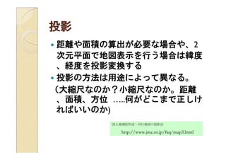
- 19. 投影 距離や面積の算出が必要な場合や、2 次元平面で地図表示を行う場合は緯度 、経度を投影変換する 投影の方法は用途によって異なる。 (大縮尺なのか?小縮尺なのか。距離 、面積、方位 …..何がどこまで正しけ ればいいのか) 国土地理院作成?刊行地図の投影法 http://www.jmc.or.jp/faq/map3.html
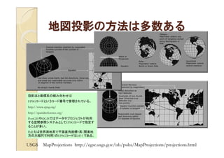
- 20. 地図投影の方法は多数ある 投影法と座標系の組み合わせは EPSGコードというコード番号で管理されている。 http://www.epsg.org/ http://spatialreference.org/ PostGISやQGISではデータやプロジェクトが利用 する空間参照システムとしてEPSGコードで指定す ることが多い。 たとえば世界測地系で平面直角座標9系(関東地 方の大縮尺で利用)のEPSGコードは2451 である。 USGS MapProjections http://egsc.usgs.gov/isb/pubs/MapProjections/projections.html
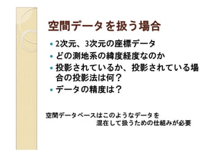
- 21. 空間データを扱う場合 2次元、3次元の座標データ どの測地系の緯度経度なのか 投影されているか、投影されている場 合の投影法は何? データの精度は? 空間データベースはこのようなデータを 混在して扱うための仕組みが必要
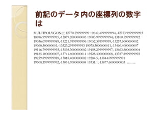
- 22. 前記のデータ内の座標列の数字 は MULTIPOLYGON(((-12770.599999999 19049.4999999994,-12753.9999999993 18986.9999999995,-12879.2000000003 19003.9999999994,-13100.5999999992 19036.0999999989,-13221.9999999996 19052.399999999,-13257.6000000002 19060.500000001,-13323.2999999993 19075.3000000011,-13460.4000000007 19116.7999999993,-13598.3000000002 19158.2999999997,-13663.8000000004 19185.1000000007,-13741.6000000011 19228.4000000008,-13787.8999999992 19259.8999999989,-13818.4000000002 19284.5,-13844.0999999991 19308.3999999992,-13861.7000000004 19331.1,-13877.6000000003 ……..
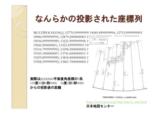
- 23. なんらかの投影された座標列 MULTIPOLYGON(((-12770.599999999 19049.4999999994,-12753.9999999993 18986.9999999995,-12879.2000000003 19003.9999999994,-13100.5999999992 19036.0999999989,-13221.9999999996 19052.399999999,-13257.6000000002 19060.500000001,-13323.2999999993 19075.3000000011,-13460.4000000007 19116.7999999993,-13598.3000000002 19158.2999999997,-13663.8000000004 19185.1000000007,-13741.6000000011 19228.4000000008,-13787.8999999992 19259.8999999989,-13818.4000000002 19284.5,-13844.0999999991 19308.3999999992,-13861.7000000004 19331.1,-13877.6000000003 …….. 実際はJGD2000平面直角座標の9系 139度50分0秒0000 36度0分0秒0000 からの投影後の距離 http://www.jmc.or.jp/faq/map/h_utm.html 日本地図センター
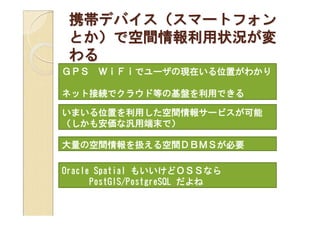
- 24. 携帯デバイス(スマートフォン とか)で空間情報利用状況が変 わる GPS WiFiでユーザの現在いる位置がわかり ネット接続でクラウド等の基盤を利用できる いまいる位置を利用した空間情報サービスが可能 (しかも安価な汎用端末で) 大量の空間情報を扱える空間DBMSが必要 Oracle Spatial もいいけどOSSなら PostGIS/PostgreSQL だよね
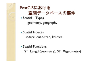
- 25. 笔辞蝉迟骋滨厂における 空間データベースの要件 Spatial Types geometry, geography Spatial Indexes r-tree, quad-tree, kd-tree Spatial Functions ST_Length(geometry), ST_X(geometry)
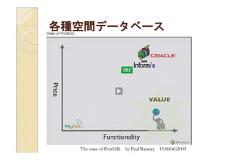
- 28. 各種空間データベース The state of PostGIS by Paul Ramsey FOSS4G2009
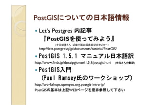
- 29. PostGISについての日本語情報 Let’s Postgres 内記事 『PostGISを使ってみよう を ってみよう』 (寺元郁博さん 近畿中国四国農業研究センター) http://lets.postgresql.jp/documents/tutorial/PostGIS/ PostGIS 1.5.1 マニュアル日本語訳 http://www.finds.jp/docs/pgisman/1.5.1/postgis.html (寺元さんの翻訳) PostGIS入門 (Paul Ramsey氏のワークショップ) http://workshops.opengeo.org.postgis-intro-jp/ PostGISの基本は上記WEBページを是非参照して下さい
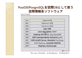
- 30. 笔辞蝉迟骋滨厂/笔辞蝉迟驳谤别厂蚕尝を空间顿叠として使う 空間情報系ソフトウェア The state of PostGIS by Paul Ramsey FOSS4G2010
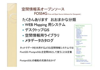
- 31. 空间情报系オープンソース FOSS4G(Free and Open Source Software for Geospatial ) たくさんあります おおまかな分類 WEB Mapping 用システム デスクトップGIS 空間情報用ライブラリ メタデータカタログ ネットでデータを共用するような空間情報システムでは 笔辞蝉迟骋滨厂/笔辞蝉迟驳谤别厂蚕尝を空间顿叠として使うことは定番 PostgreSQLの機能の充実のおかげ
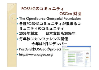
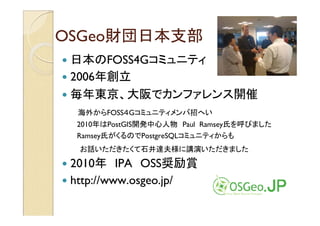
- 32. 贵翱厂厂4骋のコミュニティ OSGeo 財団 The OpenSource Geospatial Foundation 各種FOSS4Gコミュニティが集まるコ ミュニティのコミュニティ 2006年創立 日本支部も2006年 毎年秋にカンファレンス開催 今年は9月にデンバー PostGISはOSGeoのproject http://www.osgeo.org/
- 33. OSGeo財団日本支部 日本のFOSS4Gコミュニティ 2006年創立 毎年東京、大阪でカンファレンス開催 海外からFOSS4Gコミュニティメンバ招へい 2010年はPostGIS開発中心人物 Paul Ramsey氏を呼びました Ramsey氏がくるのでPostgreSQLコミュニティからも お話いただきたくて石井達夫様に講演いただきました 2010年 IPA OSS奨励賞 http://www.osgeo.jp/
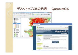
- 34. デスクトップ骋滨厂の代表 QuantumGIS
- 38. デスクトップシステムは 高機能 プログラムを新たに作らなくても使え る空間データ操作機能がたくさんあり ます。
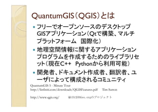
- 39. 蚕耻补苍迟耻尘骋滨厂(蚕骋滨厂)とは フリーでオープンソースのデスクトップ GISアプリケーション(Qtで構築、マルチ プラットフォーム 国際化) 地理空間情報に関するアプリケーション プログラムを作成するためのライブラリセ ット(現在C++ Pythonから利用可能) 開発者、ドキュメント作成者、翻訳者、ユ ーザによって構成されるコミュニティ QuantumGIS 5 - Minute Tour http://linfiniti.com/downloads/QGISFeatures.pdf Tim Sutton http://www.qgis.org/ QGISはOSGeo.orgのプロジェクト
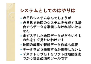
- 40. 蚕耻补苍迟耻尘骋滨厂で何ができるか 様々な種類の空間情報(ベクタ29種類以上、ラスタ53種類以上、WEB サービス3種類以上)を重ね合わせて表示(拡大、縮小、スクロール)。表示 方法設定(シンボロジー、ラベル、フィルタ、投影変換、表示順序等)。印刷。 ベクトル空間情報の入力、編集。 プラグインによる機能拡張(多彩なプラグインの存在) 空間演算(ベクタ、ラスタ) データ形式変換 統計解析(Rとの連携) WEB地図サービスとの連携 GPSデータの取り込み GPS機器連携 C++ または Pythonからのライブラリ呼び出し (独自アプリにQGIS機能組み込み) 2009年度にGUIの日本語化完了 現在ユーザガイドを日本語化中 文部科学省宇宙利用促進調整委託費 ~衛星利用の裾野拡大 プログラム~ FOSS4G を活用した衛星データ利用のためのオープン?リソース の構築 の作業で日本語化を行う http://www.osgeo.jp/foss4g-mext/
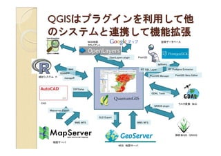
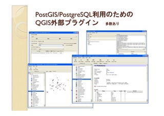
- 41. 蚕骋滨厂はプラグインを利用して他 のシステムと連携して機能拡張 WEB地図 空間データベース クライアント OpenLayers plugin PostGIS pgQuery spqr RT SQL Layer RT Postgres Extractor SDA4PP PostGIS Manager PostGIS Qery Editor 統計システム R manageR DXF2shp GDAL Tools QuantumGIS CAD ラスタ変換 加工 GRASS plugin Mapserver Export SLD Export WMS WFS WMS WFS 解析系GIS GRASS 地図サーバ WEB 地図サーバ
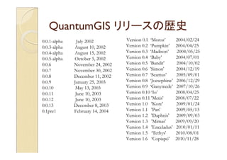
- 42. QuantumGIS リリースの歴史 0.0.1-alpha July 2002 Version 0.1 ‘Moroz’ 2004/02/24 0.0.3-alpha August 10, 2002 Version 0.2 ‘Pumpkin’ 2004/04/25 0.0.4-alpha August 15, 2002 Version 0.3 ‘Madison’ 2004/05/25 0.0.5-alpha October 5, 2002 Version 0.4 ‘Baby’ 2004/07/01 0.0.6 November 24, 2002 Version 0.5 'Bandit' 2004/10/02 0.0.7 November 30, 2002 Version 0.6 'Simon' 2004/12/19 0.0.8 December 11, 2002 Version 0.7 ‘Seamus’ 2005/09/01 0.0.9 January 25, 2003 Version 0.8 ‘Joesephine’ 2006/12/29 0.0.10 May 13, 2003 Version 0.9 ‘Ganymede’ 2007/10/26 0.0.11 June 10, 2003 Version 0.10 ‘Io’ 2008/04/25 0.0.12 June 10, 2003 Version 0.11 'Metis' 2008/07/22 0.0.13 December 8, 2003 Version 1.0 'Kore' 2009/01/24 0.1pre1 February 14, 2004 Version 1.1 'Pan' 2009/05/13 Version 1.2 'Daphnis' 2009/09/03 Version 1.3 'Mimas' 2009/09/20 Version 1.4 'Enceladus' 2010/01/11 Version 1.5 ‘Tethys' 2010/08/01 Version 1.6 ‘Copiapó' 2010/11/28
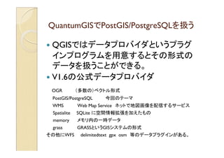
- 43. QuantumGISでPostGIS/PostgreSQLを扱う QGISではデータプロバイダというプラグ インプログラムを用意するとその形式の データを扱うことができる。 V1.6の公式データプロバイダ OGR (多数の)ベクトル形式 PostGIS/PostgreSQL 今回のテーマ WMS Web Map Service ネットで地図画像を配信するサービス Spatialite SQLite に空間情報拡張を加えたもの memory メモリ内の一時データ grass GRASSというGISシステムの形式 その他にWFS delimitedtext gpx osm 等のデータプラグインがある。
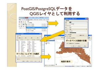
- 44. 笔辞蝉迟骋滨厂/笔辞蝉迟驳谤别厂蚕尝データを QGISレイヤとして利用する データベース接続の定義 テーブル(レイヤ)の選択 地図の表示
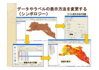
- 45. データやラベルの表示方法を変更する (シンボロジー) ラベル表示方法の定義 地図の表示 描画方法の定義
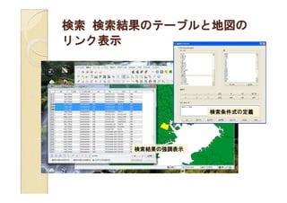
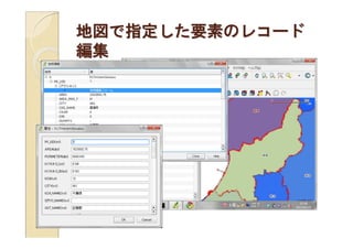
- 46. 検索 検索結果のテーブルと地図の リンク表示 検索条件式の定義 検索結果の強調表示
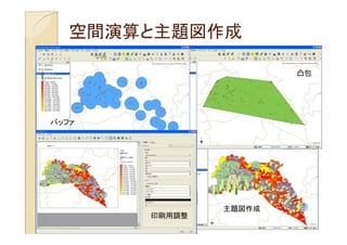
- 47. 空间演算と主题図作成 凸包 バッファ 主題図作成 印刷用調整
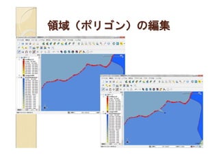
- 49. 领域(ポリゴン)の编集
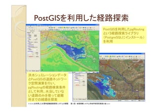
- 52. 笔辞蝉迟骋滨厂を利用した経路探索 PostGISを利用したpgRouting という経路探索ライブラリ (PostgreSQLにインストール) を利用 洪水シュミレーションデータ とPostGISの道路ネットワー ク空間演算を行い、 pgRoutingの経路検索条件 として利用。水没していな い道路のみを使って避難 所までの経路を探索 FOSS4Gを利用した水害時避難経路探索システムの構築 第19回 地理情報システム学会学術研究発表大会 2010
- 54. ご清聴ありがとうございました 関連情報WEBページ OSGeo財団 http://www.osgeo.org/ OSGeo財団日本支部 http://www.osgeo.jp/ QuantumGIS http://www.qgis.org/ QuantumGIS 日本語情報作成 http://www.osgeo.jp/qgiswiki/ GIS学会 FOSS4G分科会 http://sites.google.com/site/foss4gsig/ OSGeo4W (QGISが含まれるWindows用FOSS4G統合環境) http://trac.osgeo.org/osgeo4w/wiki/OSGeo4W_jp 月の杜工房 QGIS豆知識 http://mf-atelier.sakura.ne.jp/mf-atelier/modules/tips/index.php/software/qgis/ QGIS、PostGISについての日本語での質問、ご相談はOSGeo.jpのメーリングリスト http://lists.osgeo.org/mailman/listinfo/osgeojapan-discuss にお願いいたします。